Securing Access to Drinking Water in North-Eastern Morocco: The Example of the Taourirt-Oujda Corridor

1
Laboratory of Geosciences Applied to Engineering Planning, Hassan II University of Casablanca, Faculty of Sciences, Km 8 Route d’El Jadida, Casablanca 20150, Morocco
2
National Office of Electricity and Drinking Water, Avenue Belhassan El ouazzani, BP. Rabat-Chellah, Rabat 10002, Morocco
*
Author to whom correspondence should be addressed.
Water 2020, 12(4), 928; https://doi.org/10.3390/w12040928
Submission received: 4 November 2019
/
Revised: 4 February 2020
/
Accepted: 12 February 2020
/
Published: 25 March 2020
(This article belongs to the Special Issue Groundwater Resilience to Climate Change and High Pressure)
Abstract
:Taourit-Oujda corridor (T.O.C.) is a geological entity of north-eastern Morocco with a total area of 4000 Km2. The drinking water supply in this arid region still faces challenges that meet a growing demand for a shortage of fresh water. This shortage is mainly due to the scarcity and irregularity of the precipitations, the overexploitation of the water resources, and the decrease of the capacity of storage dams that are the main source of drinking water supply in this area. This work aims at estimating deficit (to 2040) for drinking water provided by Machraa Hammadi dam and proposing favourable drilling sites to strengthen drinking water supply through the identification of groundwater resources that can be used in quantity and quality. To do this, a multi-criteria analysis (MCA) covering geological, hydrogeological and hydro-chemical aspects using the Geographical Information System (GIS) was carried out. This study shows that T.O.C. aquifer is more productive in the south-west of it, in the centre near the El Aioun municipality and in the north-east at the town of Sidi Bouhouria. According to Moroccan standards, defining the quality norms of surface waters, waters destined for irrigation, and of surface waters used for the production of drinking water, the groundwater in the center and north-east areas is also with good to medium overall quality groundwater.
1. Introduction
Recently, water allocation is facing profound challenges due to climate change [1]. The Assessment fourth Report of the Intergovernmental Panel on Climate Change (IPCC) stated that the global warming would be responsible for changes in the hydrological cycle with major alterations in the timing of wet and dry seasons [2], which significantly impact water resources [3,4].
North Africa, which is part of the southern rim of the Mediterranean, is one of the regions where the impacts on water resources are the most important [5,6]. Many projections over the Mediterranean forecast a substantial warming and drying that would modify precipitation patterns, decrease precipitation amounts and increase the intensity and frequency of extreme event in this region [7,8,9,10]. The expected increase in air temperature is likely to intensify evapotranspiration. Combined with an expected decrease in precipitation, this should induce a net decrease in freshwater availability [11,12] and aggravate the already critical water situation [13]. Currently, the southern and eastern rims of the Mediterranean are experiencing high to severe water stress that will affect the sustainability and management of water resources [11].
Morocco is a semi-arid country in North Africa, facing water scarcity and deteriorating water quality [14] due to periods of intense droughts that the country have experienced in recent decades [15,16,17]. They are characterized by a decrease in rain fall and a tendency to increase temperatures. A pronounced precipitation decrease is observed, particularly in the east, north-east and south regions [10,16]. Morocco shows not solely a decrease in mean precipitation but also a change in the precipitation distribution in extreme events [16,17]. Climate projections suggest also reduced precipitation and a sharp decline in water resources availability [1]. Currently, the potential of water resources in Morocco is estimated at 22 Gm3/year, or about 700 m3/inhab. The surface water is estimated at 18 Gm3/year and groundwater at 4.2 Gm3/year [18]. More than half of these resources are concentrated in the northern and central Atlantic watersheds with average annual intake of the order of 11.3 Gm3/year. The average annual intake at the oriental basins is only 1.65 Gm3/year [19]. Important challenges such as population growth, urbanization, economic expansion, and climate change are looming over water security in Morocco. Urban water demand is expected to rise by 60% to 100% in most large cities by 2050 [20].
To face these challenges, 130 dams are already in operation to serve for water supply, generation of hydroelectricity and flood control [19]. In 1995, the Moroccan Water Law (n°. 10–95) introduced decentralized integrated water management and rationalisation of water use, including the user-pays and polluter-pays principles [21]. It also dictates the development of national and river basin master plans, which are elaborated in accordance with the national water strategy. To cope with water scarcity and pollution, the national water strategy includes action plans to reduce demand, increase supply and preserve and protect water resources [22]. It also proposes legal and institutional reforms for proper implementation and enforcement of these actions [23]. The strategy of water plans to increase water supply including the construction of more dams and a large north–south inter-basin water transfer, protection of existing hydraulic infrastructure, desalinization of sea water, and reuse of treated wastewater. Institutions have been set up at all levels of government, and rules are in place to involve civil society and the private sector in water management [20]. This institutional development was accompanied by new claims regarding the management and preservation of natural resources, including groundwater resources. Aquifer contracts were introduced for this purpose [24].
Taourirt-Oujda corridor (T.O.C.), located in north-eastern Morocco, is part of the Moulouya river basin where water scarcity has long been a problem [25]. The latter suffers from severe imbalance between potential water availability and minimum per capita water needs [26]. Annual rainfall is relatively low and irregular. Annual cumulative precipitation may range from 100 mm to 600 mm. Water accumulation in the summer months is greatly reduced due to high evapotranspiration rates [16,26]. In this region, the economy is predominantly agriculture-based [27]. The agricultural sector consumes more than 80% of total mobilized water resources [28]. Water demands will amplify by additional pressures, such as population growth [26] and increasing siltation rates of existing dams of the Moulouya River [25,29]. Indeed, Machraa Hammadi dam, which is the main source of drinking water supply in the study area, has shown a continuous decrease of its storage rate after periods of recurring drought, and according to forecasts, the dam will be silted up by 2030 [28]. The combination of growing water demand and increasingly limited surface water availability will lead to severe water supply problems [29,30]. In many arid and semi-arid regions where lakes and rivers are drying out, groundwater is the main possible alternative to meet the surface water deficit [31]. Groundwater is typically of good quality because of natural purification processes and it is less susceptible to pollution compared to surface water [32]. Our focus in this work is to establish, firstly, the balance “drinking water needs—available water resources” to deduce the deficit of water resources by 2040 under the inclusion of population projections [33,34]. Two scenarios were developed for 2016–2040: (i) Drinking water supply is provided both by surface water and groundwater. (ii) Drinking water supply is provided exclusively by groundwater, supposing that Machraa Hammadi dam is silted up. The estimated deficit should be filled from favourable drilling sites targeted in this study. To identify these favourable sites, we combined data on piezometric level, productivity of the aquifer and groundwater quality using a geographic information system GIS (ArcGIS 10.3 of ESRI) [35,36]. The favourable sites should be the areas where the aquifer system is the most productive and with water quality meeting Moroccan regulations of drinking water production [37,38], that is, complying with World Health Organisation guidelines. The favourable sites, thus mapped, should be useful to decision-makers for efficient groundwater catchment considering not only cost but also population health.
2. Materials and Methods
2.1. Geological and Hydrogeological Context
T.O.C. is administratively a part of the Oriental Region, which includes Oujda-Angad municipality and a part of Taourirt municipality. The population is close to 800,000 inhabitants, of which approximately 83.5% reside in urban areas, and it is expected to exceed 1,100,000 inhabitants by 2030 [34].
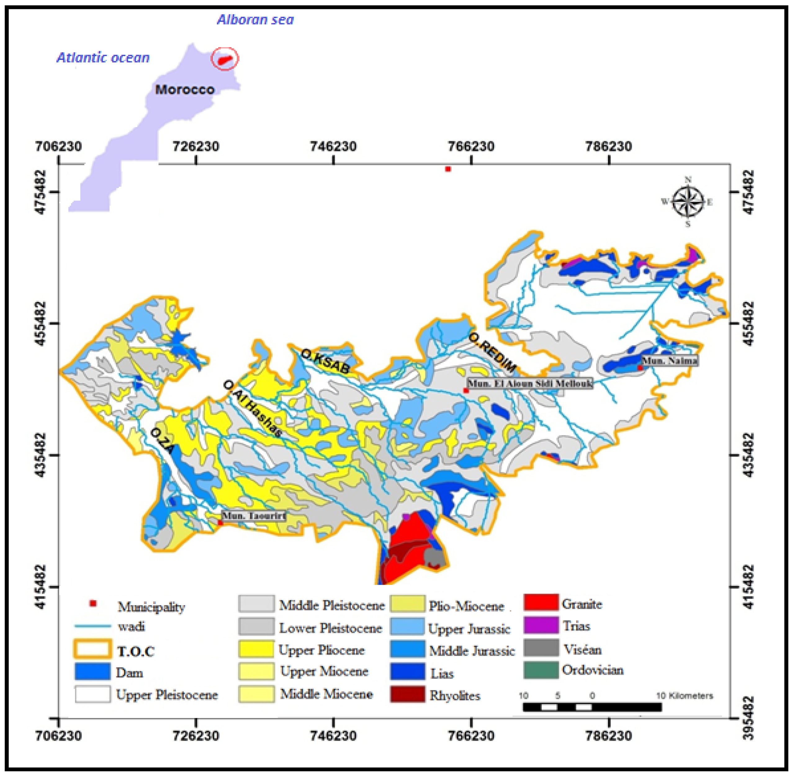
Geologically, T.O.C. is a part of the eponymous structural unit, bounded by the Beni Snassen massifs to the north and the horsts chain to the south in a SW–NE orientation. The structure of the corridor is organized in individual basins in horst and graben, controlled by combined NW–SE to NNW–SSE faults that show distal regional geodynamics from the Triassic to the Late Cretaceous [39] and compression by tectonic inversion towards the end of the Miocene [40]. The geological outcrops in this corridor are dominated by the Jurassic and Mio-Plio-Quaternary formations (Figure 1). The Domerian formations are the largest and most characteristic outcrop of the corridor [41].
The identification of groundwater resources in T.O.C. is based on the compilation of geological and hydrogeological studies [41,43,44], the results of exploration geophysics [45,46,47,48], and data provided by 110 drillings made by the Moulouya Basin Water Agency. Two hydrogeological units have been identified, namely the Taourirt-Naima unit and the Bouhouria unit.
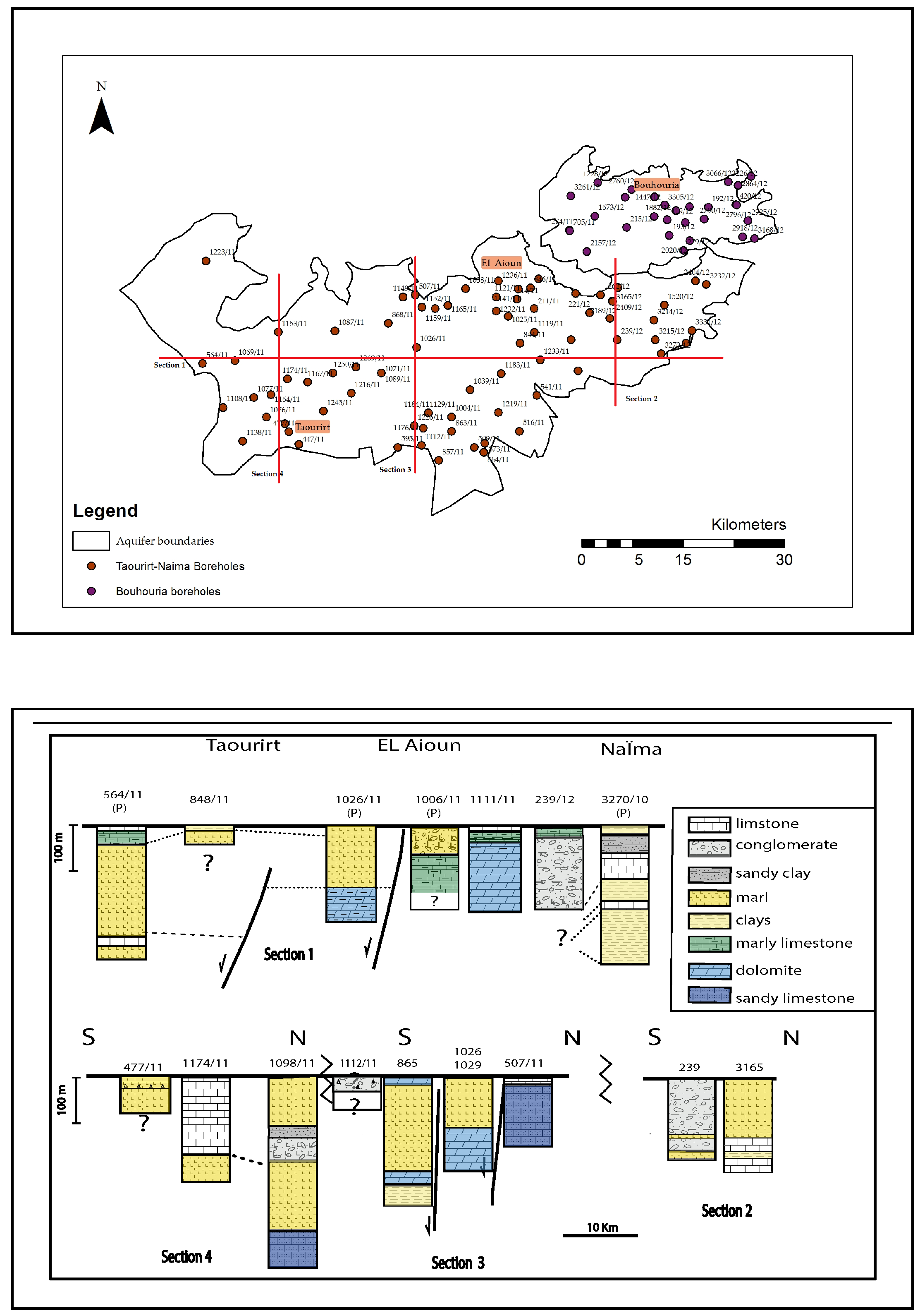
2.1.1. Hydrogeological Unit of Taourirt-Naima
Two aquifers have been identified in this unit (Figure 2):
The recharge of Taourirt-Naima aquifer is generated by three types of inputs: the rainfall, whose recharge rate is estimated at 4%; the lateral contributions estimated at 8.4 Mm3/year; and irrigation returns estimated at 4.2 Mm3/year [28].
2.1.2. Hydrogeological Unit of Bouhouria
The Bouhouria plain contains a superficial aquifer circulating in heterogeneous plio-quaternary formations [42,44]. Water depth ranges from 30 m in the south to 80 m in the north. The groundwater direct recharge is estimated at 5–14 Mm3/year; lateral intakes at 3 Mm3/year; and irrigation returns at 2 Mm3/year [28].
2.2. Estimation of Drinking Water Deficit for 2040
In T.O.C., drinking water is provided mainly by Machraa Hammadi Dam that will be silted according to the forecasts [28].
The drinking water deficit is deducted from the balance sheet “drinking water needs—available water resources”. Drinking water needs, by 2040, have been evaluated on the basis of the following equation used by the Moroccan office of Water.
CTn = a(n) × P(n) × Qb + (1 − a(n)) × P(n) × Qnb + P(n) × Qac(n) + P(n) × Qi(n) + P(n) × Qt(n)
n: the year of calculation. CT(n): Total drinking water needs for the year n. a(n): connection rate (%). P(n): total population. Qb: endowment of the connected population. Qnb: endowment of the non-connected population. Qac(n): administrative and communal endowment. Qi(n): industrial endowment. Qt(n): tourist endowment.
The data were provided by the National Office of Drinking Water, detailing the various parameters that made it possible to estimate the needs of each municipality in T.O.C. Tourism needs are not considered in this work because tourism activity is almost non-existent in T.O.C. Table 1 and Table 2 show the estimated drinking water needs of Oujda and Taourirt, respectively.
Estimated drinking water needs are compared with surface water and groundwater resources allocated to the drinking water supply (on the horizon for 2040) by the Master Plan for Integrated Management of Water Resources [28]. The balance sheet is established by considering two scenarios:
- -
- Current scenario: Machraa Hammadi dam is not yet silted up: In this case, we continue to withdraw the current rate (273 L/s) to produce drinking water: 246 L/s for Oujda and 27 L/s for Taourirt.
- -
- Pessimistic scenario: Machraa Hammadi dam is silted up. In this case, the drinking water supply is provided exclusively from groundwater.
2.3. Identification of Favourable Drilling Sites
Implementing a water catchment drilling requires a precise device and complex criteria. According to Boukrentach et al. [35], Onétié-Zahibo et al. [49], and Jourda et al. [50], the most important parameters identified to achieve the goal of this study are the flow rates of boreholes, water depth, and water quality.
Productivity map includes a geological units map and flows rates map. The suggested weights were 2 for the flow rates map and 1 for the geological map, because the crucial information is the flow rate that the aquifer can provide, and geology was secondary information, giving an idea about the potential of infiltration.
The data used to establish the productivity maps come from the Moulouya Water Agency and cover 110 drills distributed homogeneously in the study area [Supplementary Material 1].
2.4. Determination of Water Quality
Groundwater samples from 22 wells, homogeneously distributed on the corridor, were collected in March 2017 in new pre-cleaned polypropylene bottles and sterilized glass bottles (for bacteriology) [51]. The parameters measured and recorded in situ were potential hydrogen (pH), temperature and electrical conductivity using a multi-parameter instrument (Eutech instruments PCD 650) to insure more reliable results [52]. All samples were stored at 4 °C in the dark and transported to the laboratory in the same day. The samples that were used for chlorides and sulphates were filtered on a 0.45 μm membrane as soon as they were received in the laboratory [51]. Faecal coliforms were determined in the same day according to ISO 9308-1 [53]. Nitrates were determined by absorption molecular spectrometry [51,54,55].
The chemical analyses of the chlorides and sulfate were carried out by ion chromatography according to ISO 10304 [51]. The anions were separated on an IonPac AS 23–24 mm Column at 30 °C. The injection volume was 25 μL. Chloride and sulphate eluted at 6 and 17.3 min, respectively using as flow rate 1.0 mL/min and an eluent concentration of 4.5 mm. For detection, a suppressed conductivity with ASRS Ultra II (4 mm) AutoSuppressor recycle mode was used. The results are presented in the form of maps (using ArcGIS 10.3 of ESRI) and graphs (Excel 2013 of Microsoft). The maps interpretation refers to the Moroccan standards [37,38], relating to the quality of water used for the production of drinking water.
3. Result and Discussion
3.1. Determination of the Drinking Water Deficit to 2040
3.1.1. Case of Oujda Municipality
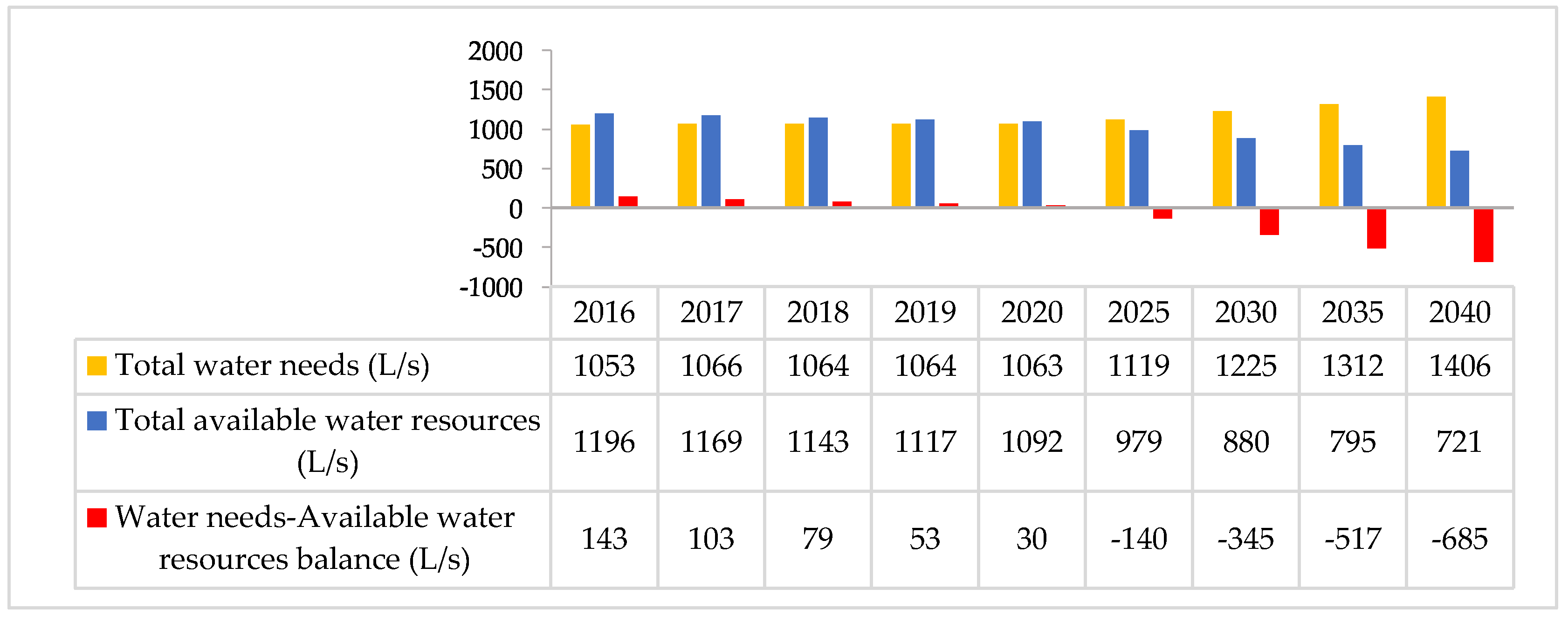
The average need for drinking water in Oujda municipality should increase from 1053 L/s in 2016 to 1406 L/s in 2040, which represents an additional requirement of approximately 353 L/s. The forecast balance sheet, based on the current scenario, shows that a deficit should be installed as early as 2025 and reach 685 L/s by 2040 (Figure 3).
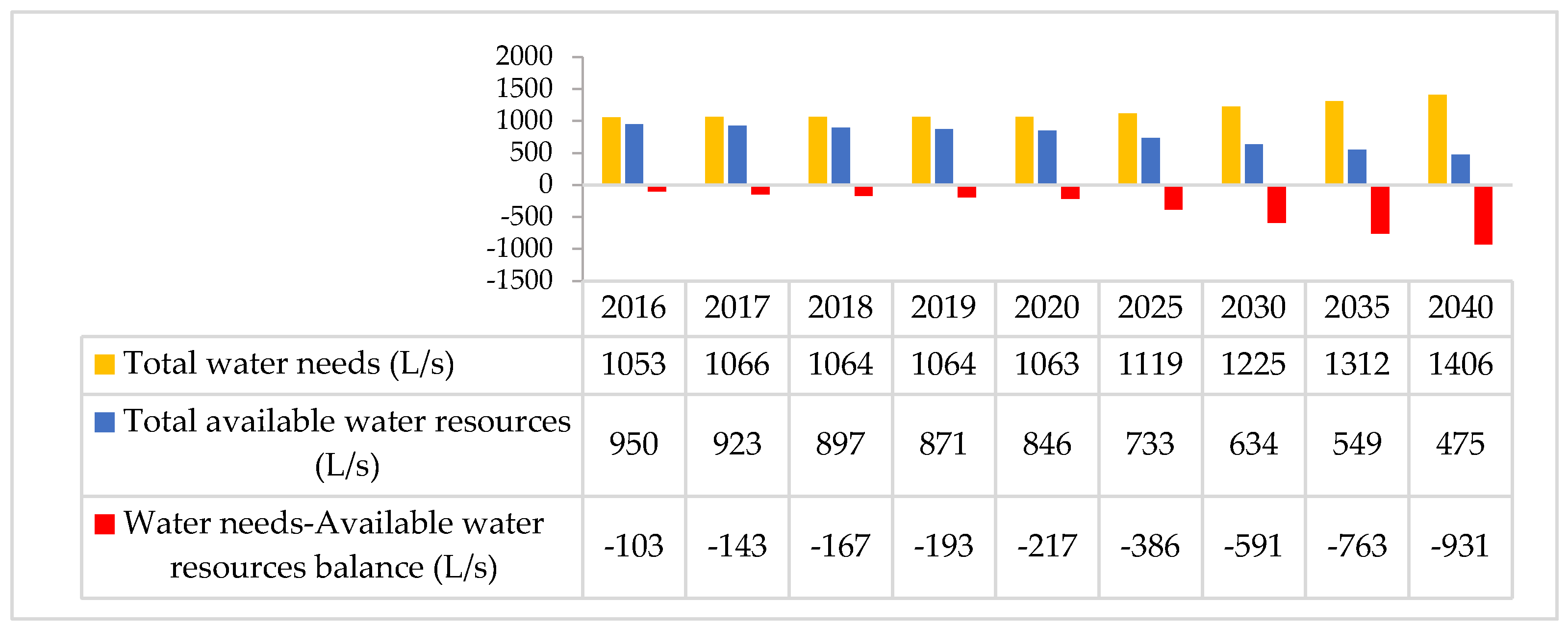
The assessment based on the pessimistic scenario indicates a deficit that accelerated from 2020 to reach 931 L/s in 2040 (Figure 4).
3.1.2. Case of Taourirt Municipality
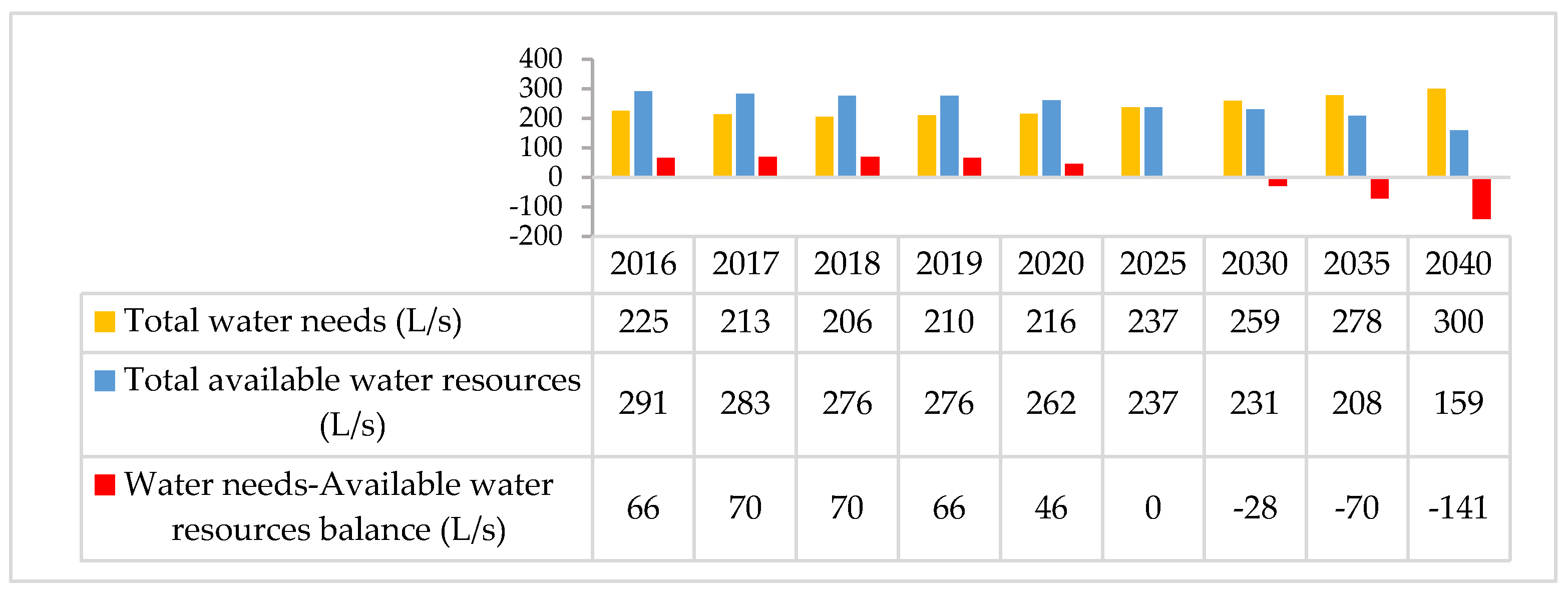
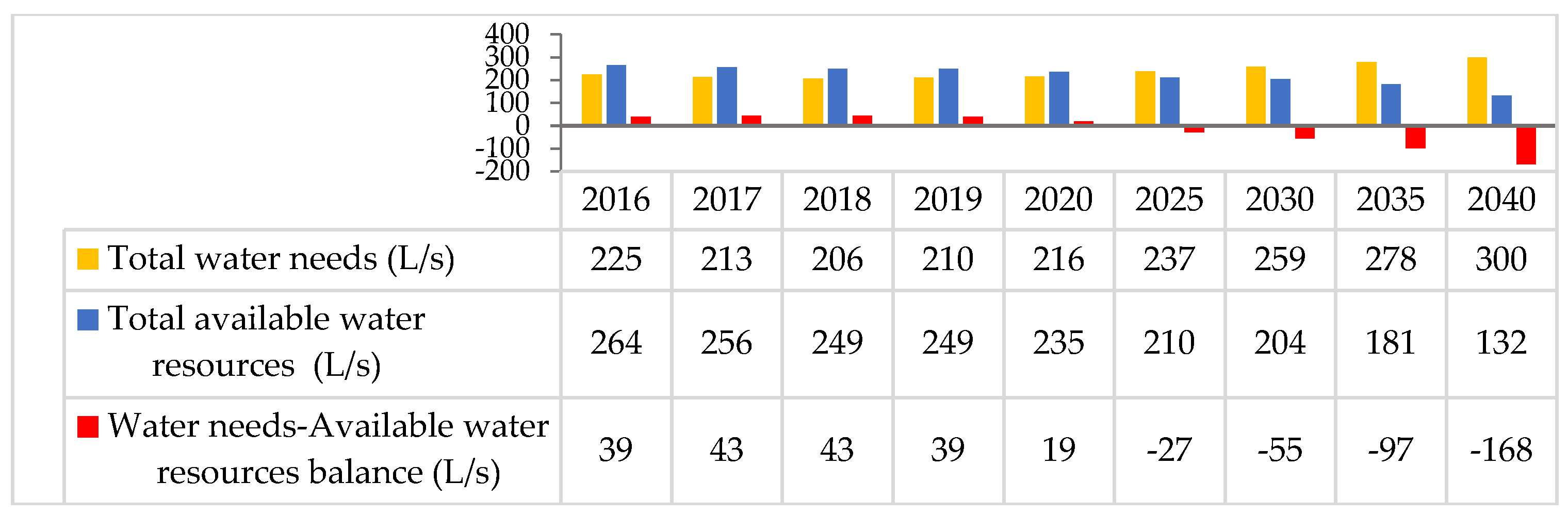
The analysis of the average water needs of the population of Taourirt, by 2040, shows an increase of 75 L/s in 2040 compared to 2016. The projected needs–resources balance sheet shows that, for the “current scenario”, a growing deficit will be recorded from 2025 and is estimated at 141 L/s by 2040 (Figure 5).
The pessimistic scenario indicates a deficit which accelerates from 2025 to reach 168 L/s in 2040 (Figure 6).
3.2. Productivity of the Aquifer of the Taourirt-Oujda Corridor
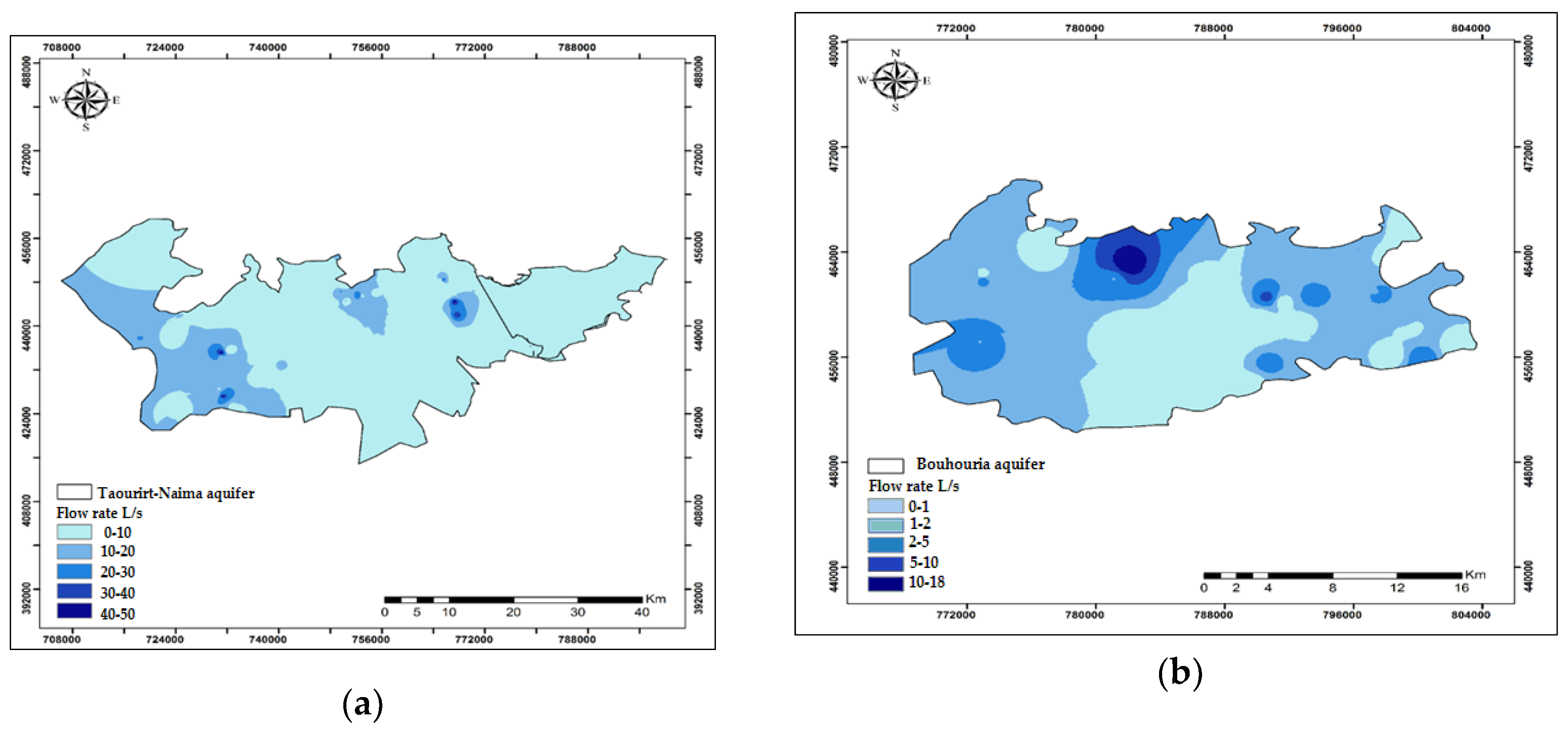
The yields from Taourirt-Naima aquifer range, in general, from 0.2 to 9 L/s with some wells capable of yielding 40 L/s in El Aioun area and 48 L/s in the south-western of the T.O.C. (Figure 7a).
In Bouhouria plain, the yields from the aquifer range from 0.3 to 2 L/s and can reach 18 L/s in Bouhouria municipality area (Figure 7b).
3.3. Characterization of the Groundwater Quality of the Taourirt-Oujda Corridor
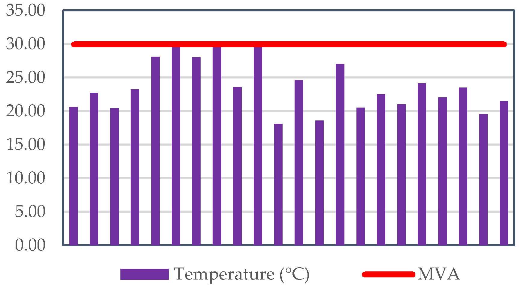
• Temperature
Eighty percent of the analyzed samples show a temperature between 28 °C and 30 °C (Figure 8). These values meet the Moroccan standards [37,38] for the quality of drinking water, which places the maximum acceptable value (MAV) at 30 °C. The highest values are observed in El Aioune area.
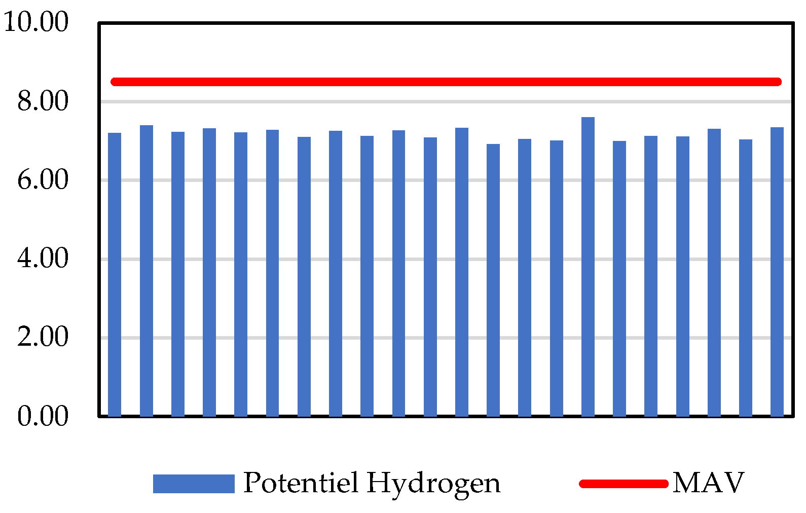
• Hydrogen potential, pH
pH values of the groundwater in the corridor do not exceed the MAV for this parameter (8.5). The maximum value recorded is 7.6 (Figure 9).
• Conductivity
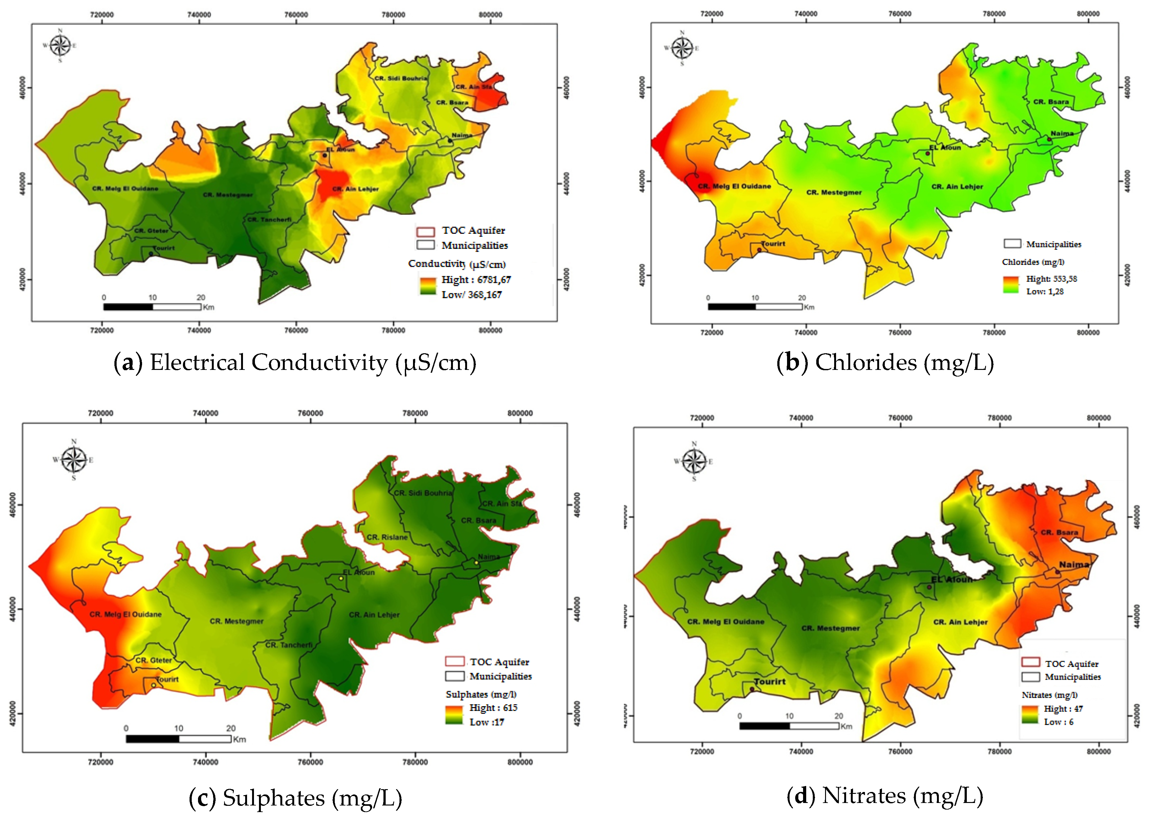
The values of the electrical conductivity in the T.O.C. range from 368 μS/cm to 6781 μS/cm. According to Moroccan standards [37,38], 56% of the sampled water had good to excellent conductivity in the western part of the T.O.C. Exceedances of the MAV (2700 μS/cm at 20 °C) are observed near Ain Lahjar and Ain Sfa municipalities (Figure 10a).
• Chlorides
The results of analyses carried out on the different samples show that the groundwater of the T.O.C. presents good quality in terms of chlorides. All the recorded values are less than 750 mg/L, which is the safe limit of this parameter (Figure 10b).
• Sulphates
The sulfate levels show an exceedance of the MAV (200 mg/L) in the west of the T.O.C. The best quality in terms of sulphate is located in the center and north-east of the corridor (Figure 10c).
• Nitrates
The spatial distribution of nitrate levels (Figure 10d) shows a variation of these levels ranging from 6 mg/L to 47 mg/L, but remain below the safe limit (50 mg/L).
• Overall quality of groundwater resources in Taourirt-Oujda corridor
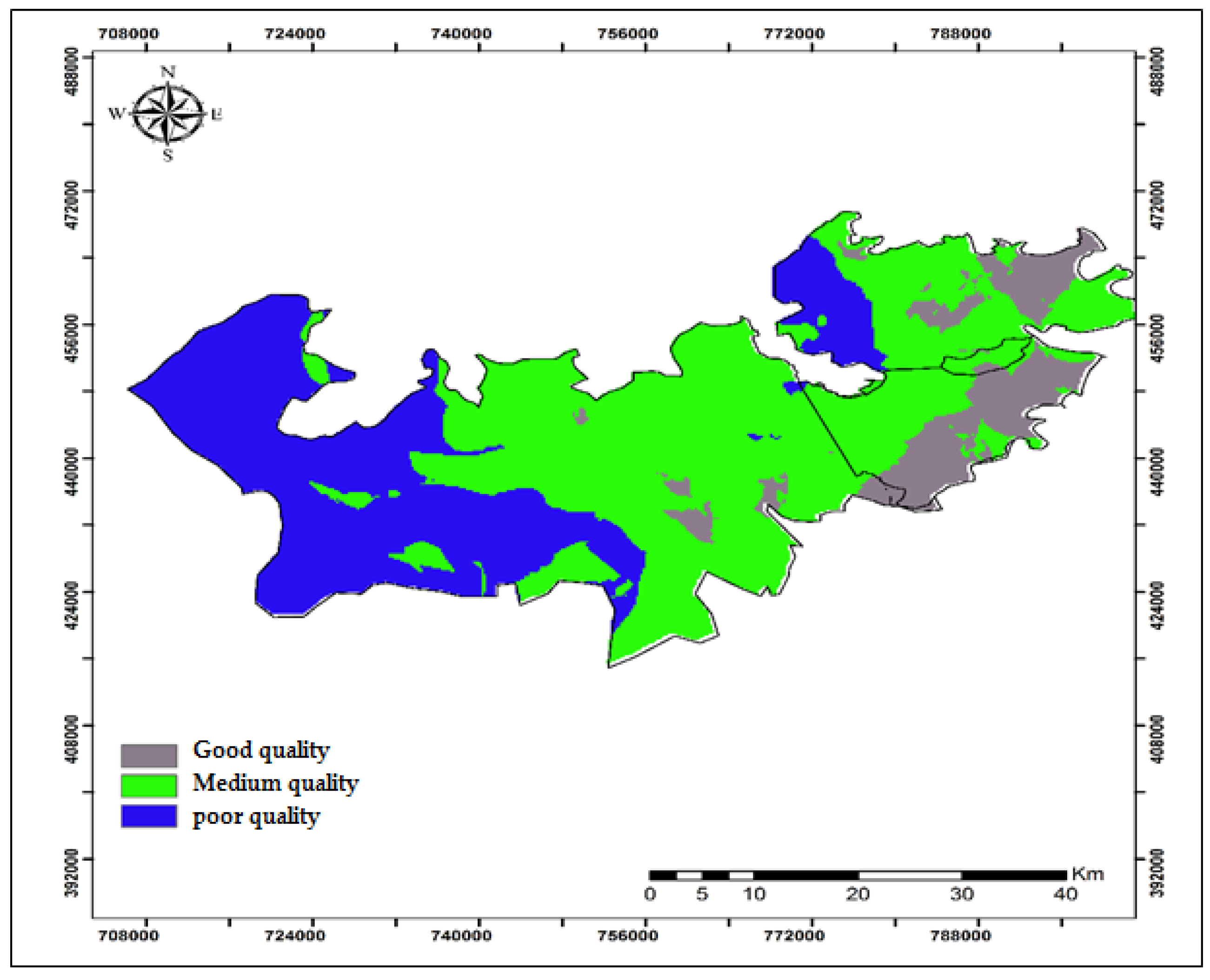
The assessment of the groundwater overall quality in the T.O.C. is based on a regulatory simplified grid. This grid sets five classes of groundwater quality according to the uses for which they are destined [37] (Table 3). Concerning the bacteriological groundwater quality, the samples analyzed showed less than three faecal coliforms per 100 mL.
Figure 11 shows that the groundwater of the T.O.C. is mostly of medium quality and can be used for drinking water supply after treatment. The poor quality of the west and south-west is mainly due to the high levels of chlorides.
4. Conclusions
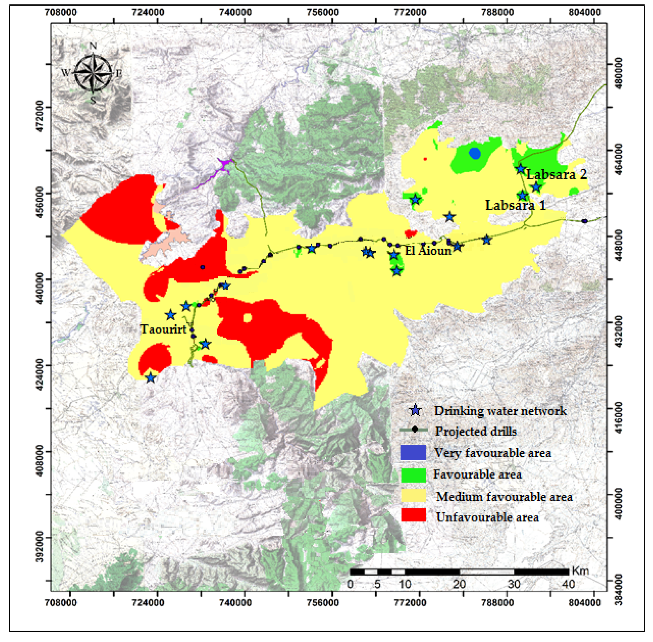
T.O.C. aquifers are more productive in the south-western area, in the centre near El Aioun municipality, and in the north at Sidi Bouhouria. These areas also have good to medium overall quality of groundwater that can be used for drinking water supply. These data, combined with the operating conditions relating to the drinking water supply, namely the proximity to the supply network, have made it possible to propose sites for future drilling that could compensate for the recorded deficit (Figure 12). Based of the following map, two boreholes: Labsara 1 and Labsara 2 were drilled in the favorable area by the National Office of Water. The drillings provide a flow rate of 22 L/s and 9 L/s respectively (Supplementary Material).
The deficit that will be generated by the siltation of the Machraa Hammadi dam remains estimated because it is based on projections. However, this deficit alarms us about the future of drinking water supply in the study region. It is important to emphasize that the endowment from underground resources in the study area is very limited. It is therefore important to consider alternative solutions to increase sustainable access to water, including: (a) master plan for the over exploitation of the water resources; (b) measures to confront the deterioration of their quality; (c) measures and works to delay the decrease of the capacity of storage dams and to elongate its life; (d) and use of unconventional water resources such as the reuse of wastewater and rainwater harvesting.
Supplementary Materials
The following are available online at https://www.mdpi.com/2073-4441/12/4/928/s1, Text 1: T.O.C. Boreholes data; Text 2: Labsara drillings.
Author Contributions
Conceptualization, H.J. and T.R.; Formal analysis, H.J. and T.A.; Investigation, H.J. and T.A.; Methodology, H.J., T.R. and A.B.; Software, T.A.; Supervision, H.J., T.R. and A.B.; Validation, A.B.; Writing—original draft, H.J. and T.R. All authors have read and agreed to the published version of the manuscript.
Funding
This research received no external funding.
Acknowledgments
The authors would like to thank: (1) Moroccan National Office of Water and Moulouya Water Agency for providing us with Data on drinking water supply in the study area. (2) The reviewers for their relevant comments and suggestions which helped to improve the manuscript.
Conflicts of Interest
The authors declare no conflict of interest.
References
- Yan, D.; Ludwig, F.; Huang, H.Q.; Werners, S.E. Many-objective robust decision making for water allocation under climate change. Sci. Total Environ. 2017, 607, 294–303. [Google Scholar] [CrossRef] [PubMed]
- Bates, B.C.; Kundzewicz, Z.W.; Wu, S.; Palutikof, J.P. Climate Change and Water; IPCC Technical Paper VI; IPCC Secretariat: Geneva, Switzerland, 2008; Available online: http://www.ipcc.ch/pdf/technical-papers/climate-change-water-en.pdf (accessed on 1 December 2019).
- Levitus, S. Anthropogenic warming of Earth’s climate system. Science 2001, 292, 267–270. [Google Scholar] [CrossRef] [PubMed]
- Vose, R.S. Impact of land-use change on climate. Nature 2004, 427, 213–214. [Google Scholar] [CrossRef] [PubMed]
- Iglesias, A.; Garrote, L.; Flores, F.; Moneo, M. Challenges to Manage the Risk of, Water Scarcity and Climate Change in the Mediterranean. Water. Resour. Manag. 2007, 21, 775–788. [Google Scholar] [CrossRef]
- García-Ruiz, J.M.; López-Moreno, J.I.; Vicente-Serrano, S.M.; Lasanta-Martínez, T.; Beguería, S. Mediterranean water resources in a global change scenario. Earth Sci. Rev. 2011, 105, 121–139. [Google Scholar] [CrossRef] [Green Version]
- Giorgi, F.; Lionello, P. Climate change projections for the Mediterranean region. Glob. Planet. Chang. 2008, 63, 90–104. [Google Scholar] [CrossRef]
- Somot, S.; Sevault, F.; Déqué, M.; Crépon, M. 21st century climate change scenario for the Mediterranean using a coupled atmosphere–ocean regional climate model. Glob. Planet. Chang. 2008, 63, 112–126. [Google Scholar] [CrossRef] [Green Version]
- Schilling, J.; Korbinian, P.F.; Hertige, E.; Scheffran, J. Climate change, vulnerability and adaptation in North Africa with focus on Morocco. Agr. Ecosyst. Environ. 2012, 156, 12–26. [Google Scholar] [CrossRef]
- Knippertz, P.; Christoph, M.; Speth, P. Long-term precipitation variability in Morocco and the link to the large-scale circulation in recent and future climates. Meteorol. Atmos. Phys. 2003, 83, 67–88. [Google Scholar] [CrossRef]
- Milano, M.; Ruelland, D.; Fernandez, S.; Dezetter, A.; Fabre, J.; Servat, E.; Fritsch, J.-M.; Ardoin-Bardin, S.; Thivet, G. Current state of Mediterranean water resources and future trends under climatic and anthropogenic changes. Hydrol. Sci. J. 2013, 58, 498–518. [Google Scholar] [CrossRef]
- Milly, P.C.D.; Dunne, K.A.; Vecchia, A.V. Global patterns of trends in streamflow and water availability in a changing climate. Nature 2005, 438, 347–350. [Google Scholar] [CrossRef] [PubMed]
- Sowers, J.; Vengosh, A.; Weinthal, E. Climate change, water resources, and the politics of adaptation in the Middle East and North Africa. Clim. Chang. 2011, 104, 599–627. [Google Scholar] [CrossRef]
- Mas-Pla, J.; Font, E.; Astui, O.; Menció, A.; Rodríguez-Florit, A.; Folch, A.; Pérez-Paricio, A. Development of a stream–aquifer numerical flow model to assess river water management under water scarcity in a Mediterranean basin. Sci. Total Environ. 2012, 440, 204–218. [Google Scholar] [CrossRef]
- EL Hafid, D.; Zerrouqi, Z.; Akdim, B. Study of drought sequences in the ilsly basin (East Morocco). LARHYSS J. 2017, 31, 83–94. [Google Scholar]
- Driouech, F.; Déqué, M.; Mokssit, A. Numerical simulation of the probability distribution function of precipitation over Morocco. Clim. Dyn. 2009, 32, 1055–1063. [Google Scholar] [CrossRef]
- Stour, L.; Agoumi, A. Climatic drought in Morocco during the last decades. Hydroécol. Appl. 2008, 16, 215–232. [Google Scholar] [CrossRef] [Green Version]
- Ministry of Energy, Mining, Water and Environment. Resources en Eau; Ministry of Energy, Mining, Water and Environment: Rabat, Morocco. Available online: http://81.192.10.228/ressources-en-eau/presentation-general/ (accessed on 2 December 2019).
- Agoumi, A.; Debbarh, A. Ressources en Eau et Bassins Versants du Maroc: 50 Ans De Développement (1955–2005). Available online: http://www.rdh50.ma/fr/pdf/contributions/GT8-1.pdf (accessed on 2 December 2019).
- World Bank Group. Managing Urban Water Scarcity in Morocco; World Bank Group: Washington, DC, USA, 2017; Available online: https://elibrary.worldbank.org/doi/abs/10.1596/29190 (accessed on 3 December 2019).
- Official State Gazette. Royal Decree no. 1-95-154 Promulgating Law No. 10-95 on Water; Official State Gazette: Rabat, Morocco, 1995; Available online: http://gis.nacse.org/rewab/docs/Royal_Decree_No_1-95-154_Promulgating_Law_on_Water_EN.pdf (accessed on 4 December 2019).
- Ministry of Energy, Mining, Water and Environment. Stratégie Nationale de L’Eau; Ministry of Energy, Mining, Water and Environment: Rabat, Morocco. Available online: www.minenv.gov.ma/PDFs/EAU/strategie_eau.pdf (accessed on 2 December 2019).
- Schyns, J.F.; Hoekstra, A.Y. The added value of water footprint assessment for national water policy: A case study for Morocco. PLoS ONE 2014, 9, e99705. [Google Scholar] [CrossRef]
- Del Vecchio, K.; Barone, S. Has Morocco’s groundwater policy changed? Lessons from the institutional approach. Wate. Altern. 2018, 11, 638–662. [Google Scholar]
- Snoussi, M.; Haida, S.; Imassi, S. Effects of the construction of dams on the water and sediment fluxes of the Moulouya and the Sebou Rivers, Morocco. Reg. Environ. Chang. 2002, 3, 5–12. [Google Scholar] [CrossRef]
- Tekken, V.; Kropp, P.J. Climate-Driven or Human-Induced: Indicating Severe Water Scarcity in the Moulouya River Basin (Morocco). Water 2012, 4, 959–982. [Google Scholar] [CrossRef] [Green Version]
- Ait Kadi, M.A. From water scarcity to water security in the Maghreb Region: The Moroccan Case. In Environmental Challenges in the Mediterranean 2000–2050; NATO Science Series IV; Marquina, A., Ed.; Kluwer Academic Publisher: Dordrecht, The Netherlands, 2004. [Google Scholar]
- Water Agency of Moulouya. Study of Updating and Integrated Management of Water Resources in the Area of Action of the Water Agency of Moulouya; Summary Report; Unpublished.
- Lahlou, A. The Silting of Moroccan Dams. In Sediment Budgets, Porto Alegre Symposium; IAHS Publ.: Porto Alegre, Brasil, 1988. [Google Scholar]
- Bogardi, J.J.; Dudgeon, D.; Lawford, R.; Flinkerbusch, E.; Meyn, A.; Pahl-Wostl, C.; Vielhauer, K.; Vörösmarty, C. Water security for a planet under pressure: Interconnected challenges of a changing world call for sustainable solutions. Curr. Opin. Environ. Sustain. 2012, 4, 35–43. [Google Scholar] [CrossRef]
- World Meteorological Organization (WMO). WMO Statement on the Status of the Global Climate in 2005; WMO: Geneva, Switzerland, 2006; Available online: https://library.wmo.int/doc_num.php?explnum_id=3476 (accessed on 3 December 2019).
- Diao, X.; Dinar, A.; Roe, T.; Tsur, Y. A general equilibrium analysis of conjunctive ground and surface water use with an application to Morocco. Agric. Econ. 2008, 38, 117–135. [Google Scholar] [CrossRef]
- Centre D’Etudes et de Recherches Démographiques (CERED). Projections de La Population et des Ménages 2014–2050; CERED. Available online: https://www.hcp.ma/region-drta/attachment/861157/ (accessed on 22 February 2019).
- HCP (High Commissioner for Planning). Population and Regional and Provincial Projections 2014–2030; HCP. Available online: https://www.hcp.ma/region-drta/attachment/861124/ (accessed on 22 February 2019).
- Boukrentach, H.; Benali, A.; Dekkiche, H. Combining GIS and fuzzy multi-criteria decision-making for water catchment drilling site selection. Arab. J. Geosci. 2017, 10, 538. [Google Scholar] [CrossRef]
- Kanohin, F.E.O.; Saley, M.B.; Aké, G.E.; Savané, I. Apport de la télédétection et des SIG dans l’identification des ressources en eau souterraine dans la région de Daoukro (Centre-Est de la Côte D’Ivoire). IJIAS 2012, 1, 35–53. [Google Scholar]
- Moroccan Official Bulletin. Joint Orders No. 1275-01, 1276–01 and 1277-01 of 17th October 2002 Defining the Quality Norms of Surface Waters, Waters Destined for Irrigation and of Surface Waters Used for the Production of Drinking Water Respectively; Official Bulletin of the Kingdom of Morocco no. 5062; Moroccan Official Bulletin: Rabat, Morocco, 2002; pp. 1518–1525.
- Ministry of Energy, Mining, Water and Environment. Laws and Regulations; Ministry of Energy, Mining, Water and Environment. Available online: http://http://www.environnement.gov.ma/fr/lois-et-reglementations/normes?id=1011 (accessed on 4 December 2018).
- Michard, A. Elements de Geologie Marocaine; Notes et Memoires du Service Geologique No. 252; Editions du Service Geologique du Maroc: Rabat, Morroco, 1976; p. 408. [Google Scholar]
- Zizi, M. Triassic-Jurassic External Systems and Their Neocene Reactivation in Northern Morocco (Wrinkles Prerifaines and Guercif Basin). Ph.D. Thesis, Rice University, Houston, TX, USA, 1996. [Google Scholar]
- Quang Trac, N.; Simonot, M. Water Resources of Morocco: Areas of Rif and Eastern Morocco; The Taourirt-Oujda corridor. Notes Mem. Geol. Serv. 1971, 1, 271–290. [Google Scholar]
- Choubert, M.G.; Marais, J.; Suter, G. Géologic Map of Morocco (Oujda). Notes Mem. Geol. Serv. 1956, 70, 5. [Google Scholar]
- Lahrach, A. Characterization of the Deep Liasic Reservoir of Eastern Morocco and Hydrogeological Studies, Modeling and Pollution of the Water Table of Angad. Ph.D. Thesis, Sidi Mohamed Ben Abdellah University, Fes, Morocco, 1999. [Google Scholar]
- Water Agency of Moulouya. Hydrogeological Synthesis of the Semi Deep Aquifers of the Taourirt—Naima Corridor, Unpublished Report.
- Mimouni, A.; Oujidi, M.; Negadi, M.; Hadlach, M.; Bengamra, S. Use of the geoelectric prospecting for the determination of the geometry of the miocene aquifer in the area of El Aïoun North-Eastern Morocco. IJESD 2011, 2, 491–494. [Google Scholar]
- DRPE. Study by High Resolution Seismic Reflection and Seismic Synthesis in the Middle Moulouya and the Taourirt-Oujda Corridor, Unpublished Report.
- Water Agency of Moulouya. Geophysical Study by Electrical Prospecting in the Taourirt—Naima Corridor, Unpublished Report.
- Aqil, H.; Khattach, D.; El Gout, R.; El Mandour, A.; Kaufmann, O. Gravity contribution to the study of the deep structure of Bou-Houria basin (north-eastern Morocco): Hydrogeological implications. Hydrol. Sci. J. 2015, 60, 736–745. [Google Scholar] [CrossRef]
- Onétié Zahibo, O.; Lasm, T.; Coulibaly, A.; Baka, D. Apport du SIG et de l’analyse multicritère dans la prospection hydrogéologique du socle précambrien de Gagnoa (Centre-Ouest De La Côte d’Ivoire). Eur. Sci. J. 2016, 12, 137–157. [Google Scholar]
- Jourda, J.P.; Saley, M.B.; Djagoua, E.V.; Kouame, K.J.; Biemi, J.; Razack, M. Utilisation des données ETM+ de Landsat et d’un SIG pour l’évaluation du potentiel en eau souterraine dans le milieu fissuré précambrien de la région de Korhogo (Nord de la Côte d’Ivoire): Approche par analyse multicritère et test de validation. Télédétection 2006, 5, 339–357. [Google Scholar]
- Rodier, J. L’analyse de L’eau, Eaux Naturelles, Eaux Résiduelles, Eaux de Mer, 9th ed.; Dunod: Paris, France, 2009; p. 1526. [Google Scholar]
- Garvis, D.; Stuermer, D.A. well-head instrument package for multi-parameter measurement during well water sampling. Water Res. 1980, 14, 1525–1527. [Google Scholar] [CrossRef]
- ISO. Water Quality—Detection and Enumeration of Escherichia coli and Coliform Bacteria Part 1: Membrane Filtration Method [Revision of ISO 9308-1:2000]; International Standard ISO/WD 9308-1; International Organisation for Standardization: Geneva, Switzerland, 2006. [Google Scholar]
- Annapoorna, H.; Janardhana, M.R. Assessment of groundwater quality for drinking purpose in rural areas surrounding a defunct copper mine. Aquat. Procedia 2015, 4, 685–692. [Google Scholar] [CrossRef]
- Goldman, E.; Jacobs, R. Determination of Nitrates by Ultraviolet Absorption. J. Am. Water Works Assoc. 1961, 53, 187–191. [Google Scholar] [CrossRef]
Figure 1.
Geological map of the T.O.C. Extracted from Oujda’s map [42].
Figure 1.
Geological map of the T.O.C. Extracted from Oujda’s map [42].

Figure 2.
Hydrogeological sections in the Taourirt-Naima corridor [44].
Figure 2.
Hydrogeological sections in the Taourirt-Naima corridor [44].

Figure 3.
Estimation of drinking water needs—available water resources balance sheet of Oujda municipality (Current scenario).
Figure 3.
Estimation of drinking water needs—available water resources balance sheet of Oujda municipality (Current scenario).

Figure 4.
Estimation of drinking water needs—available water resources balance sheet of Oujda municipality (Pessimistic scenario).
Figure 4.
Estimation of drinking water needs—available water resources balance sheet of Oujda municipality (Pessimistic scenario).

Figure 5.
Estimation of drinking water needs—available water resources balance sheet of Taourirt municipality (Current scenario).
Figure 5.
Estimation of drinking water needs—available water resources balance sheet of Taourirt municipality (Current scenario).

Figure 6.
Estimation of drinking water needs—available water resources balance sheet of Taourirt municipality (Pessimistic scenario).
Figure 6.
Estimation of drinking water needs—available water resources balance sheet of Taourirt municipality (Pessimistic scenario).

Figure 7.
Productivity of T.O.C. aquifers: (a) Taourirt-Naima aquifer, (b) Bouhouria aquifer.

Figure 8.
Temperature of the groundwater in the T.O.C. (March 2017).

Figure 9.
pH of the groundwater in the T.O.C. (March 2017).

Figure 10.
Spatial distribution of concentrations of (a) electrical conductivity; (b) Chlorides; (c) Sulphates; and (d) nitrates in T.O.C. aquifer (March 2017).
Figure 10.
Spatial distribution of concentrations of (a) electrical conductivity; (b) Chlorides; (c) Sulphates; and (d) nitrates in T.O.C. aquifer (March 2017).

Figure 11.
Overall Groundwater Quality of the T.O.C. (March 2017).

Figure 12.
Sites for projected drilling.


Table 1.
Estimation of drinking water needs in Oujda municipality.
| Year | 2016 | 2017 | 2018 | 2019 | 2020 | 2025 | 2030 | 2035 | 2040 |
|---|---|---|---|---|---|---|---|---|---|
| Total population (×1000 inhabitant) | 726.81 | 735.60 | 740.20 | 746.36 | 751.10 | 791.06 | 880.28 | 958.42 | 1026.97 |
| Connection rate (%) | 98 | 98 | 98 | 98 | 98 | 98 | 98 | 98 | 98 |
| Endowments (L/capita/d) | |||||||||
| Connected population | 103 | 103 | 102 | 101 | 100 | 100 | 98 | 96 | 96 |
| Non-connected population | 14 | 14 | 14 | 11 | 11 | 11 | 11 | 11 | 11 |
| Administration | 15 | 15 | 15 | 15 | 15 | 15 | 15 | 15 | 15 |
| Industry | 9 | 9 | 9 | 9 | 9 | 9 | 9 | 9 | 9 |
| Total endowment | 141 | 141 | 140 | 136 | 135 | 135 | 133 | 131 | 131 |
| Drinking water needs m3/d | |||||||||
| Connected population | 73,364.22 | 74,250.96 | 73,990.49 | 73,874.74 | 73,607.93 | 77,523.74 | 84,541.95 | 90,167.68 | 96,617.34 |
| Non-connected population | 203.51 | 205.97 | 207.26 | 164.20 | 165.24 | 174.03 | 193.66 | 210.85 | 225.93 |
| Administration | 10,902.15 | 11,033.93 | 11,103.02 | 11,195.40 | 11,266.52 | 11,865.88 | 13,204.18 | 14,376.23 | 15,404.55 |
| Industry | 6541.29 | 6620.36 | 6661.81 | 6717.24 | 6759.91 | 7119.53 | 7922.51 | 8625.74 | 9242.73 |
| Total needs (m3/d) | 91,011.17 | 92,111.21 | 91,962.57 | 91,951.59 | 91,799.60 | 96,683.18 | 105,862.29 | 113,380.49 | 121,490.55 |
| Total needs (L/s) | 1053.37 | 1066.10 | 1064.38 | 1064.25 | 1062.50 | 1119.02 | 1225.26 | 1312.27 | 1406.14 |
Table 2.
Estimation of drinking water needs in Taourirt municipality.
| Year | 2016 | 2017 | 2018 | 2019 | 2020 | 2025 | 2030 | 2035 | 2040 |
|---|---|---|---|---|---|---|---|---|---|
| Total population (×1000 inhabitant) | 240.57 | 243.02 | 244.37 | 249.01 | 256.00 | 277.22 | 303.00 | 325.41 | 351.01 |
| Connection rate (%) | 98.00 | 98.00 | 98.00 | 98.00 | 98.00 | 98.00 | 98.00 | 98.00 | 98.00 |
| Endowments (L/capita/d) | |||||||||
| Connected population | 70 | 66 | 63 | 63 | 63 | 63 | 63 | 63 | 63 |
| Non-connected population | 10 | 6 | 6 | 6 | 6 | 6 | 6 | 6 | 6 |
| Administration | 5 | 4 | 4 | 4 | 4 | 4 | 4 | 4 | 4 |
| Industry | 7 | 7 | 7 | 7 | 7 | 8 | 8 | 8 | 8 |
| Total | 92 | 83 | 80 | 80 | 80 | 81 | 81 | 81 | 81 |
| Needs m3/d | |||||||||
| Connected population | 16,502.86 | 15,718.41 | 15,087.14 | 15,373.91 | 15,805.44 | 17,115.70 | 18,706.97 | 20,090.87 | 21,671.66 |
| Non-connected population | 48.11 | 29.16 | 29.32 | 29.88 | 30.72 | 33.27 | 36.36 | 39.05 | 42.12 |
| Administration | 1202.83 | 972.07 | 977.46 | 996.04 | 1024.00 | 1108.89 | 1211.98 | 1301.64 | 1404.06 |
| Industry | 1683.96 | 1701.13 | 1710.56 | 1743.07 | 1792.00 | 2217.78 | 2423.97 | 2603.29 | 2808.12 |
| Total needs (m3/d) | 19,437.77 | 18,420.77 | 17,804.49 | 18,142.90 | 18,652.16 | 20,475.63 | 22,379.28 | 24,034.85 | 25,925.96 |
| Total needs (L/s) | 224.97 | 213.20 | 206.07 | 209.99 | 215.88 | 236.99 | 259.02 | 278.18 | 300.07 |
Table 3.
Simplified grid for assessing the overall quality of groundwater [37].
Table 3.
Simplified grid for assessing the overall quality of groundwater [37].
| Parameters | Conductivity (µS/cm) | Chlorides (mg/L) | Nitrates (mg/L) | Faecal Coliforms (per 100 mL) | Use | |
|---|---|---|---|---|---|---|
| Class | ||||||
| Excellent | <400 | <200 | <5 | <20 | Demanding Uses | |
| Good | 400–1300 | 200–300 | 5–25 | 20–2000 | DWS after normal treatment | |
| Medium | 1300–2700 | 300–750 | 25–50 | 2000–20,000 | DWS after advanced treatment | |
| Poor | 2700–3000 | 750–1000 | 50–100 | >20,000 | Irrigation, cooling | |
| Verypoor | >3000 | >1000 | >100 | >20,000 | Inapt to the uses | |
© 2020 by the authors. Licensee MDPI, Basel, Switzerland. This article is an open access article distributed under the terms and conditions of the Creative Commons Attribution (CC BY) license (http://creativecommons.org/licenses/by/4.0/).
Share and Cite
MDPI and ACS Style
Jounaid, H.; Attou, T.; Remmal, T.; Bouaziz, A. Securing Access to Drinking Water in North-Eastern Morocco: The Example of the Taourirt-Oujda Corridor. Water 2020, 12, 928. https://doi.org/10.3390/w12040928
AMA Style
Jounaid H, Attou T, Remmal T, Bouaziz A. Securing Access to Drinking Water in North-Eastern Morocco: The Example of the Taourirt-Oujda Corridor. Water. 2020; 12(4):928. https://doi.org/10.3390/w12040928
Chicago/Turabian StyleJounaid, Halima, Taha Attou, Toufik Remmal, and Aimad Bouaziz. 2020. "Securing Access to Drinking Water in North-Eastern Morocco: The Example of the Taourirt-Oujda Corridor" Water 12, no. 4: 928. https://doi.org/10.3390/w12040928
Note that from the first issue of 2016, this journal uses article numbers instead of page numbers. See further details here.