Rockfall and Debris Flow Hazard Assessment in the SW Escarpment of Montagna del Morrone Ridge (Abruzzo, Central Italy)


Abstract
:1. Introduction
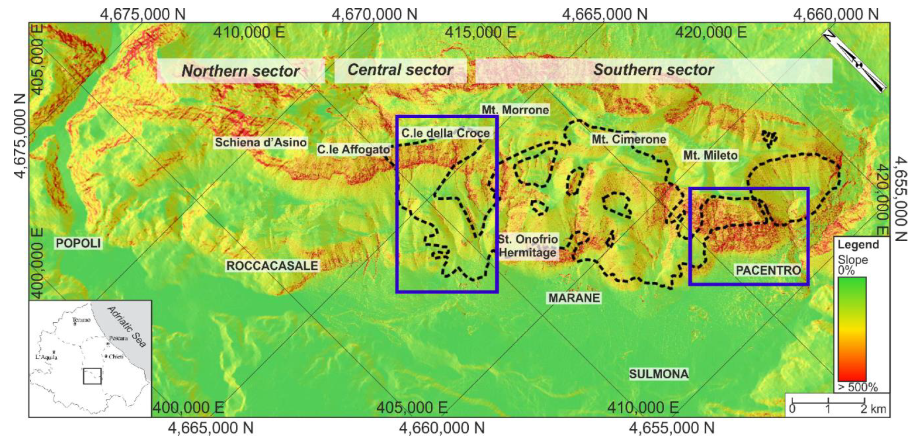
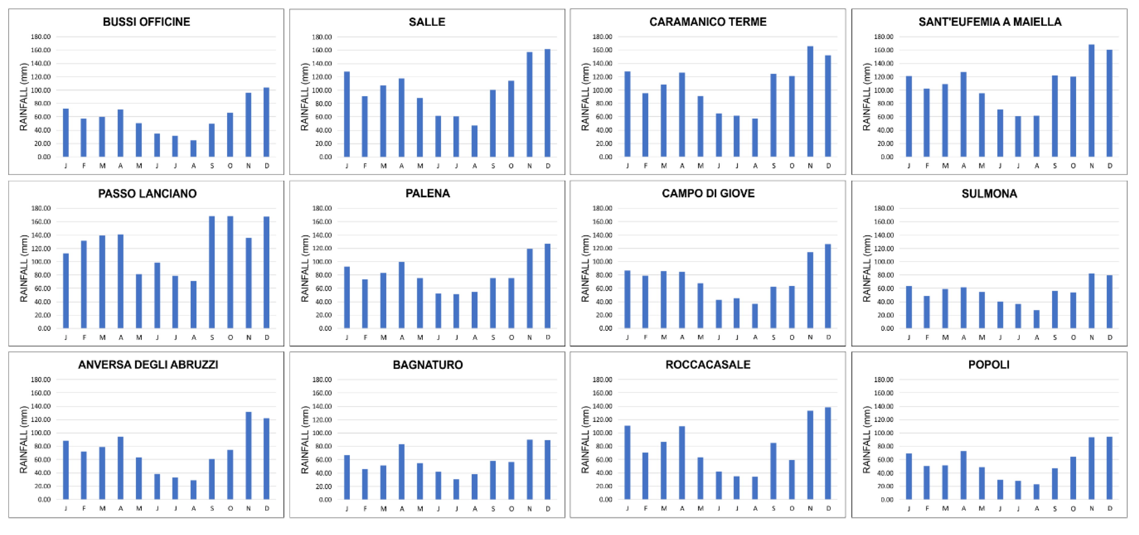
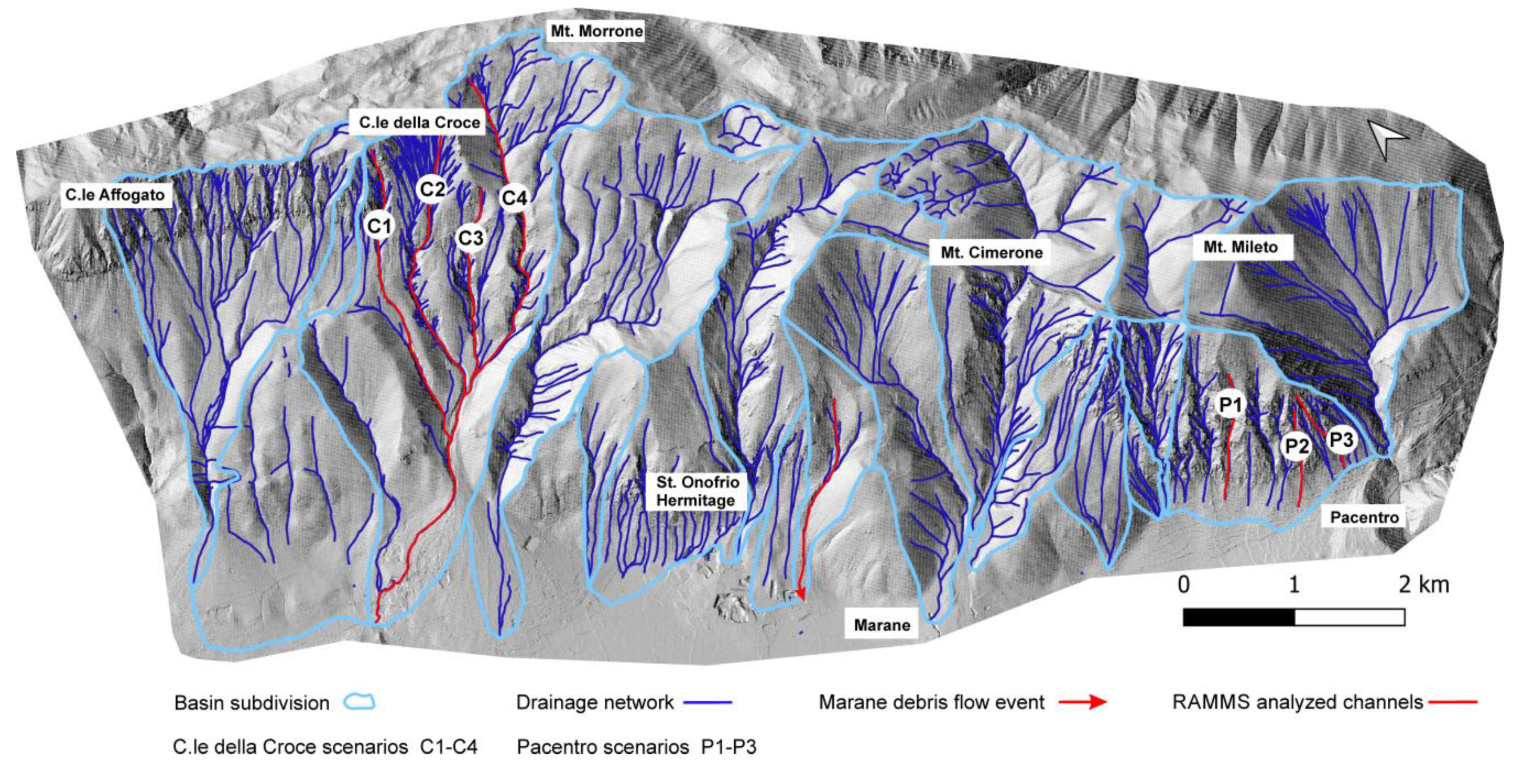
2. Study Area
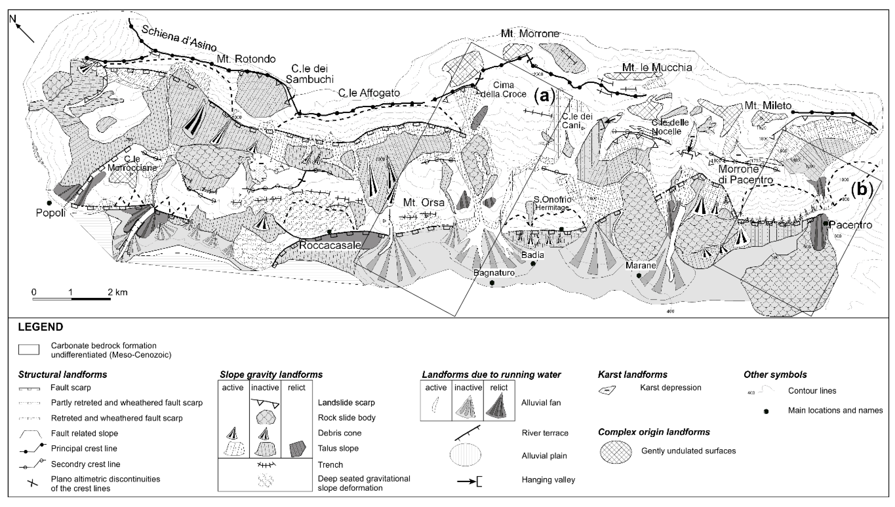
3. Geomorphological Data
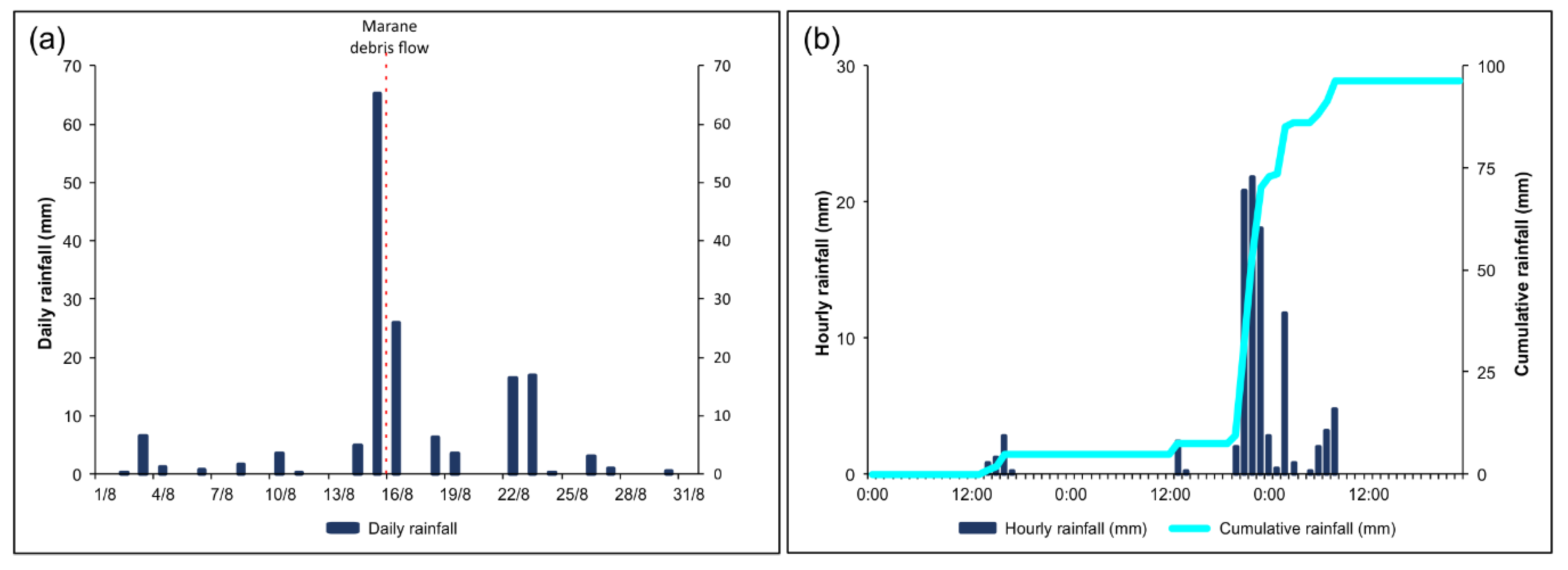
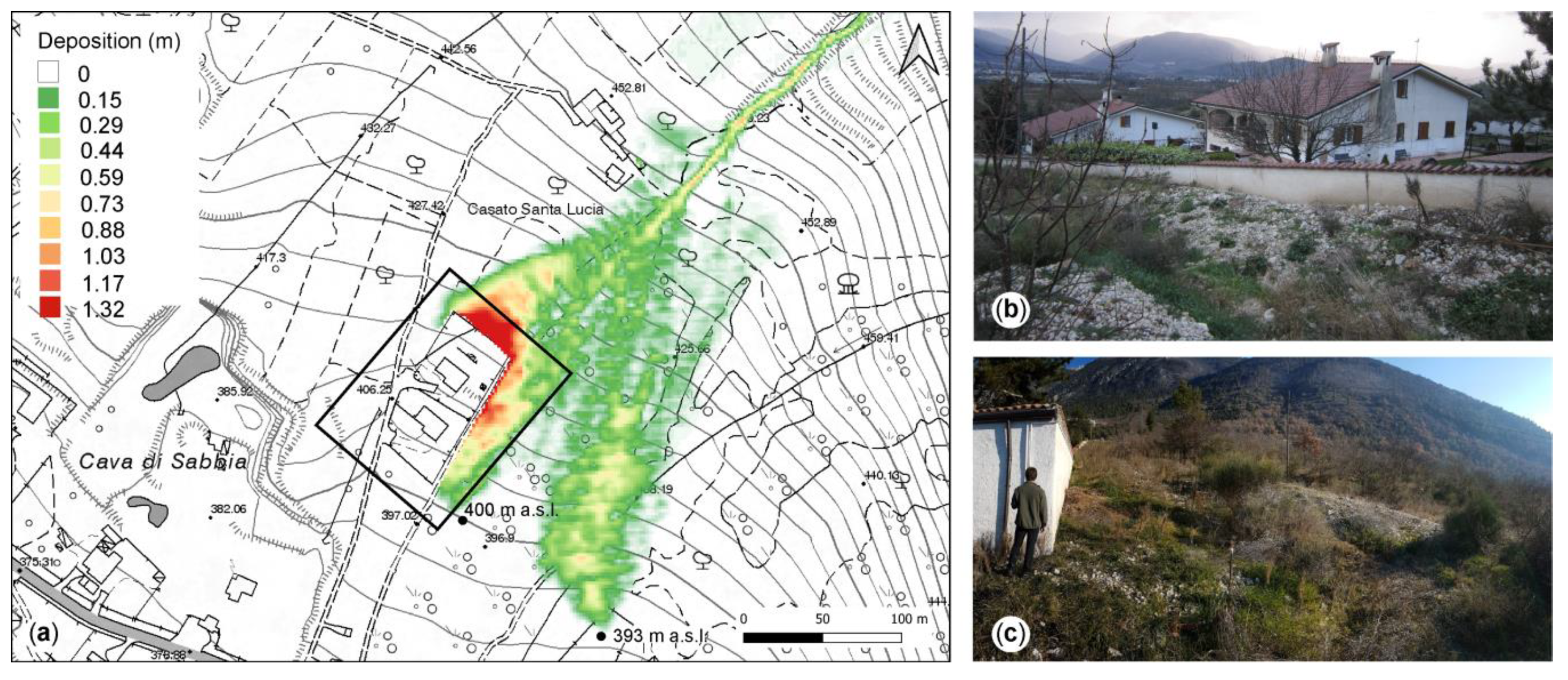
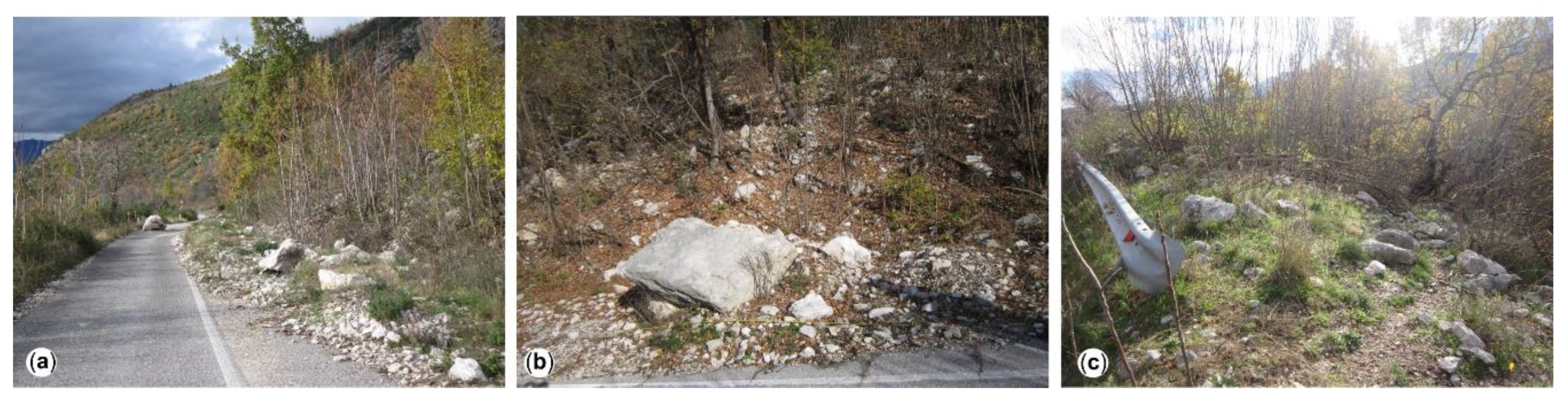
4. Main Past Landslide Events
5. Methods
5.1. Debris Flow Analysis
- digital elevation model -DEM- (2 m LIDAR—laser imaging detection and ranging);
- location and size of the released mass (debris flow detachment area);
- calculation domain: extension of the debris flow path;
- input hydrograph: the amount of material that might flow at a certain location in the channel;
- friction information: μ and ξ friction coefficients (after explained);
- angle of inflow direction with respect to the x-coordinate of the topographic data.
- Scenario 1: simulation along channel C1.
- Scenario 2: simulation along channel C2.
- Scenario 3: simulation along channel C3.
- Scenario 4: simulation along channel C4.
- Scenario 5: simultaneous simulation along channels C1-C2.
- Scenario 6: simultaneous simulation along channels C3-C4.
- Scenario 7: simultaneous simulation along channels C1-C2-C3-C4.
Rockfall Analysis
- DEM (2m × 2m) reconstructed through the UAV survey with a high-resolution camera.
- Volume weight of the materials: 2500 kg/m3 for the cells considered possible sources of collapse, where more or less porous calcareous lithotypes outcrop.
- Size, shape, and volume variations of the blocks involved.
- Slope roughness: values ranging from: (a) 0 to 0.15 m in areas along the slope characterized by bedrock; (b) 0.02 to 0.1 m in areas where the substrate shows meteoric degradation material; (c) 0.1 to 0.6 m in areas with slope debris; (d) near the anthropic forms (roads, buildings) values equal to 0 were assigned.
- Land use: slope debris (value 4), bedrock with fine material of meteoric degradation (value 5), bedrock (value 6), and roads (value 7).
- Number of trees per hectare: maximum value of 1200 trees/hectare for areas with dense forest, minimum of 100 trees/hectare for sparse shrub areas; areas without vegetation have a value equal to 0.
- Diameter of the trunks: from 30 cm in areas with dense vegetation and/or olive groves to 20 cm in areas with medium or sparse vegetation; if vegetation is absent, the value assigned is 0.
- Variation in the diameter of the trunks: equal to 15 cm in areas with tree vegetation.
- Case 1: medium-large sized blocks (1 × 0.7 × 0.5 with +/− 20% volume variation) with vegetation cover.
- Case 2: as Case 1 without vegetation cover.
- Case 3: modest sized blocks (0.2 × 0.2 × 0.2 with +/− 50% volume variation) with vegetation cover.
- Case 4: as Case 3 without vegetation cover.
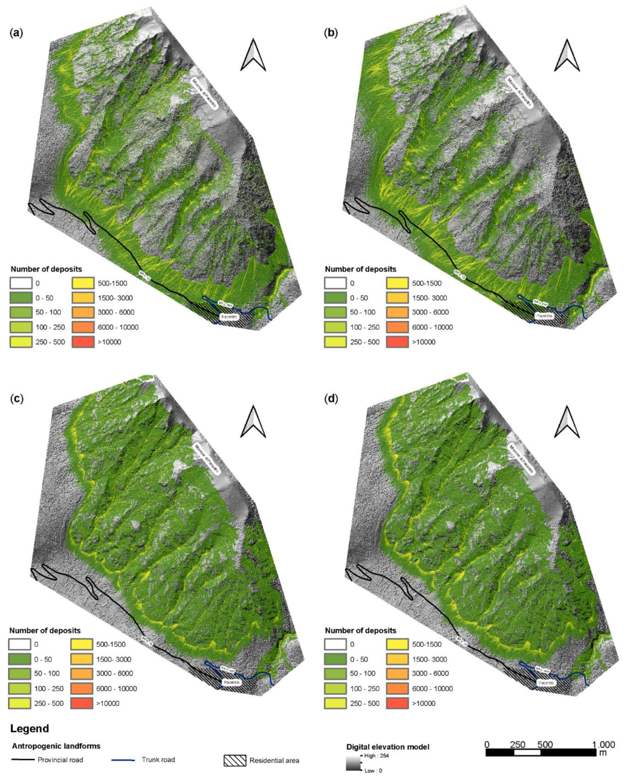
6. Results
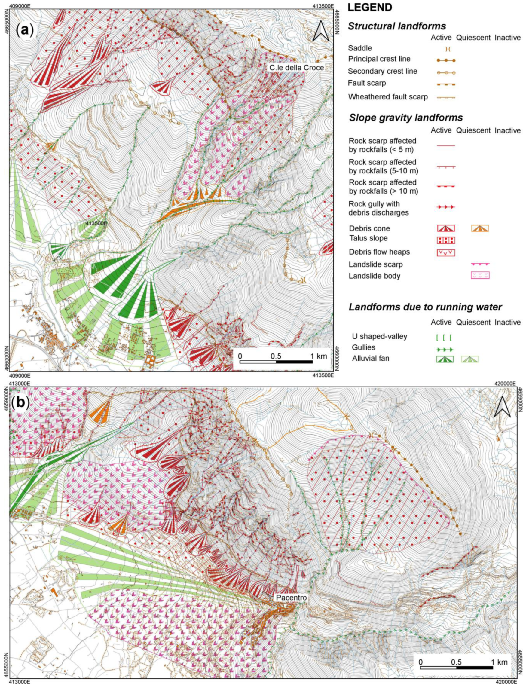
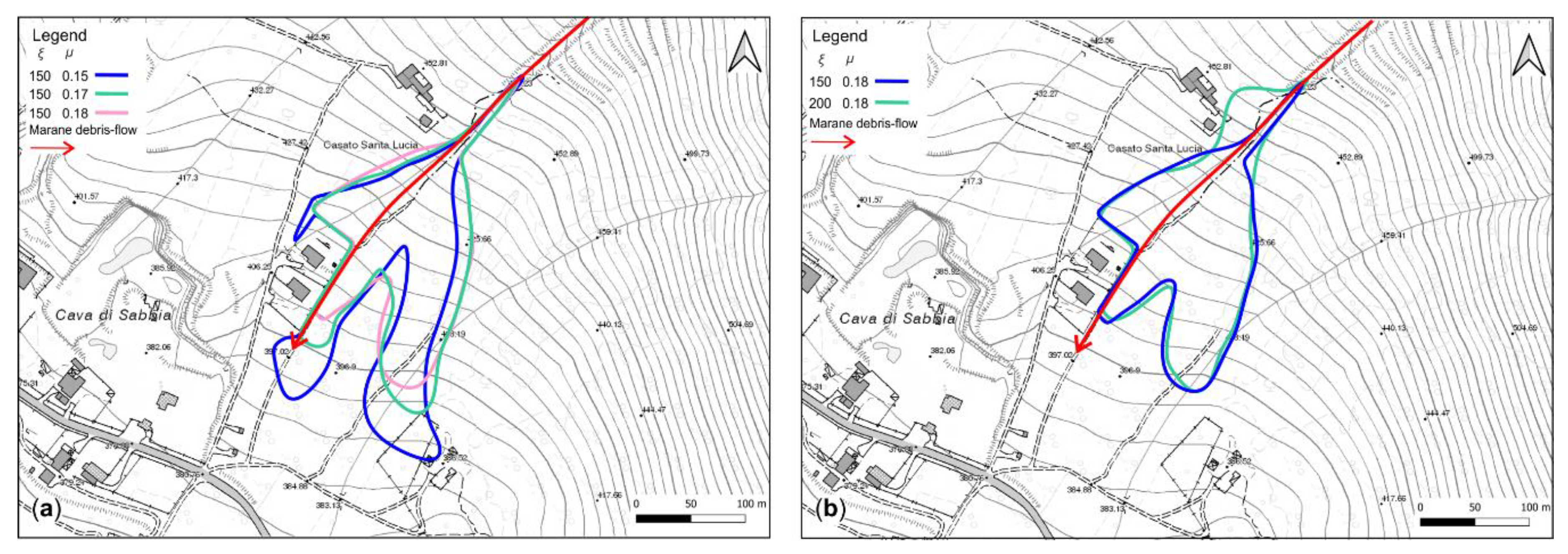
6.1. Colle della Croce Results
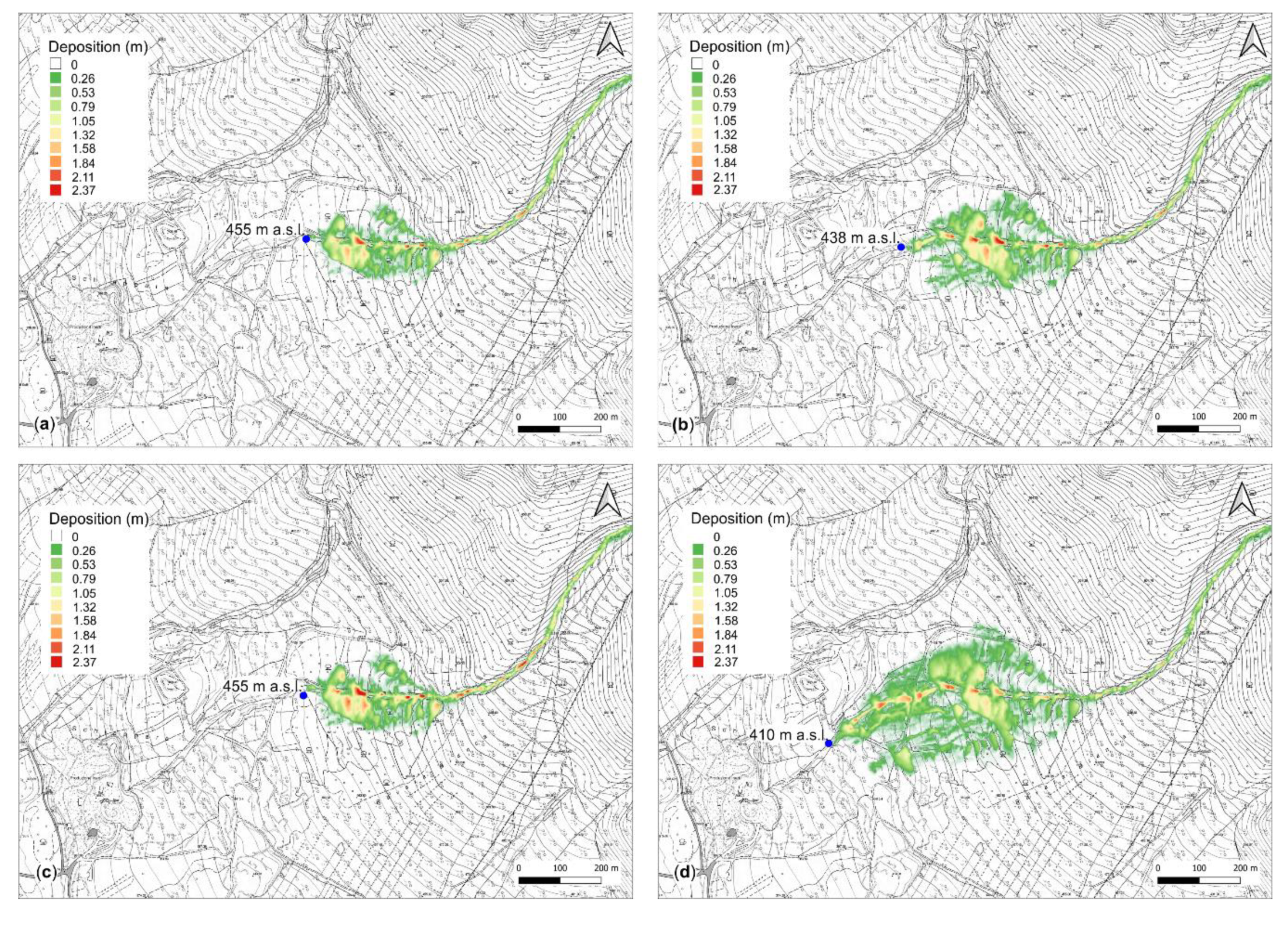
6.1.1. Single Channels Numerical Modeling Results
6.1.2. Channels Pairs Numerical Modeling Results
6.1.3. Total Channels Analysis
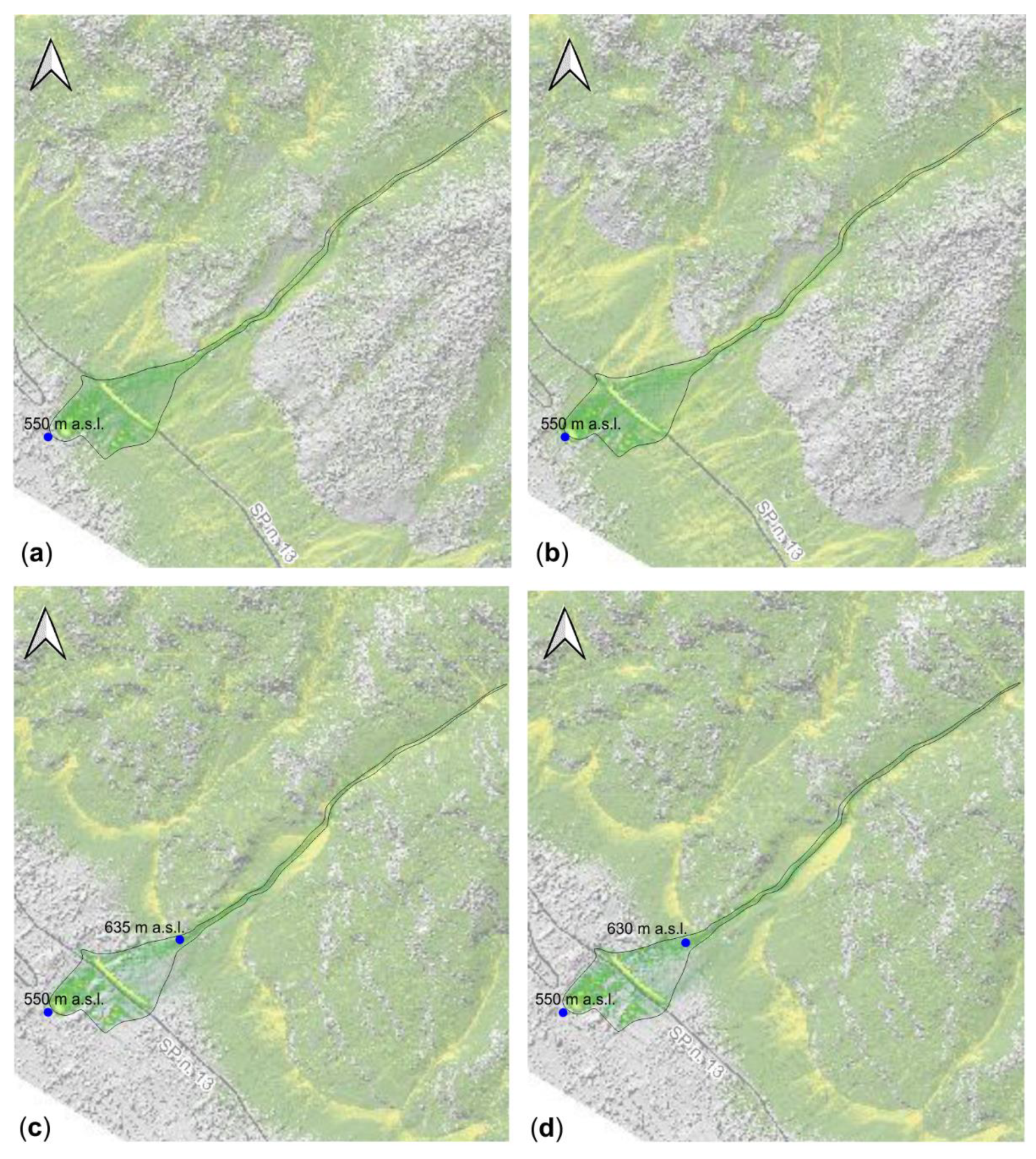
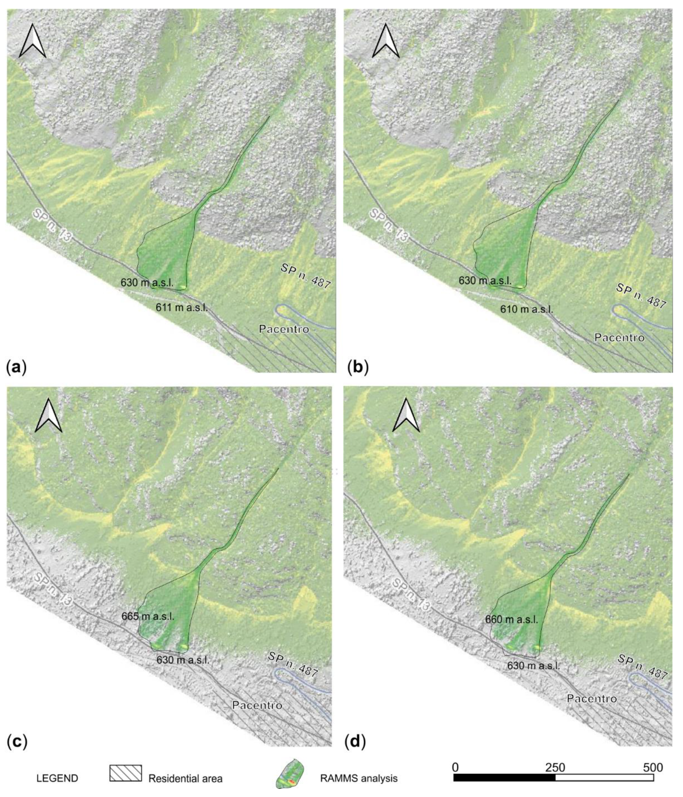
6.2. Pacentro Results
7. Discussion
Author Contributions
Funding
Acknowledgments
Conflicts of Interest
References
- Guzzetti, F.; Reichenbach, P.; Cardinali, M.; Galli, M.; Ardizzone, F. Probabilistic landslide hazard assessment at the basin scale. Geomorphology 2005, 72, 272–299. [Google Scholar] [CrossRef]
- Aleotti, P.; Chowdhury, R. Landslide hazard assessment: Summary review and new perspectives. Bull. Eng. Geol. Environ. 1999, 58, 21–44. [Google Scholar] [CrossRef]
- Von Ruette, J.; Lehmann, P.; Or, D. Rainfall-triggered shallow landslides at catchment scale: Threshold mechanics-based modeling for abruptness and localization. Water Resour. Res. 2013, 49, 6266–6285. [Google Scholar] [CrossRef]
- Crosta, G.B.; Frattini, P. Distributed modelling of shallow landslides triggered by intense rainfall. Nat. Hazards Earth Syst. Sci. 2003, 3, 81–93. [Google Scholar] [CrossRef] [Green Version]
- D’Alessandro, L.; Miccadei, E.; Piacentini, T. Morphostructural elements of central-eastern Abruzzi: Contributions to the study of the role of tectonics on the morphogenesis of the Apennine chain. Quat. Int. 2003, 101–102, 115–124. [Google Scholar] [CrossRef]
- Parotto, M.; Cavinato, G.P.; Miccadei, E.; Tozzi, M. Line CROP 11: Central Apennines. In CROP Atlas: Seismic Reflection Profiles of the Italian Crust; Scrocca, D., Doglioni, C., Innocenti, F., Manetti, P., Mazzotti, A., Bertelli, L., Burbi, L., D’O_zi, S., Eds.; Memorie Descrittive della Carta Geologica d’Italia: Rome, Italy, 2004; Volume 6, pp. 145–153. [Google Scholar]
- Ciccacci, S.; D’Alessandro, L.; Dramis, F.; Miccadei, E. Geomorphologic evolution and neotectonics of the Sulmona intramontane basin (Abruzzi Apennine, Central Italy). Z. Geomorphol. Suppl. 1999, 118, 27–40. [Google Scholar]
- Calista, M.; Miccadei, E.; Pasculli, A.; Piacentini, T.; Sciarra, M.; Sciarra, N. Geomorphological features of the Montebello sul Sangro large landslide (Abruzzo, Central Italy). J. Maps 2016, 12, 882–891. [Google Scholar] [CrossRef] [Green Version]
- Piacentini, T.; Miccadei, E. The role of drainage systems and intermontane basins in the Quaternary landscape of the Central Apennines chain (Italy). Rend. Lincei 2014, 25, 139–150. [Google Scholar] [CrossRef]
- Beneo, E. Sezioni geologiche attraverso la Montagna del Morrone (Appennino Abruzzese). Boll. Reg. Uff. Geo. d’It. 1939, 64, 1–17. [Google Scholar]
- Vezzani, L.; Ghisetti, F. Domini in compressione e in distensione al retro dei fronti del Gran Sasso—M. Picca e del M. Morrone: Il ruolo della zona di taglio Avezzano-Bussi (Appennino centrale). Studi Geol. Camerti 1995, 475–490. [Google Scholar] [CrossRef]
- Miccadei, E.; Barberi, R.; Cavinato, G.P. La geologia quaternaria della Conca di Sulmona (Abruzzo, Italia centrale). Geol. Romana 1999, 34, 58–86. [Google Scholar]
- Carabella, C.; Miccadei, E.; Paglia, G.; Sciarra, N. Post-Wildfire Landslide Hazard Assessment: The Case of The 2017 Montagna Del Morrone Fire (Central Apennines, Italy). Geosciences 2019, 9, 175. [Google Scholar] [CrossRef] [Green Version]
- Rickenmann, D. Empirical relationship for debris flows. Nat. Hazards 1999, 19, 47–77. [Google Scholar] [CrossRef]
- Dorren, L.K.A.; Simoni, S. Rockyfor3D (v 5.1) Rivelato—Descrizione Trasparente del Modello 3D di Caduta Massi; EcorisQ: Ginevra, Switzerland, 2014; 27p. [Google Scholar]
- Frattini, P.; Crosta, G.B.; Carrara, A.; Agliardi, F. Assessment of rockfall susceptibility by integrating statistical and physically-based approaches. Geomorphology 2008, 94, 419–437. [Google Scholar] [CrossRef]
- Scarascia Mugnozza, G.; Bianchi Fasani, G.; Esposito, C. Le frane catastrofiche in roccia: Un fattore di rischio in Appennino? S.L.M. Riv. dell’IMONT 2006, 27, 14–21. [Google Scholar]
- Budetta, P. Assessment of rock fall risk along roads. Nat. Hazards Earth Syst. Sci. 2004, 4, 71–81. [Google Scholar] [CrossRef] [Green Version]
- Piacentini, T.; Miccadei, E.; Di Michele, R.; Sciarra, N.; Mataloni, G. Geomorphological analysis applied to rock falls in Italy: The case of the San Venanzio gorges (Aterno river, Abruzzo, Italy). Ital. J. Eng. Geol. Environ. 2013, 6, 467–479. [Google Scholar]
- Miccadei, E.; Paron, P.; Piacentini, T. The SW escarpment of Montagna del Morrone (Abruzzi, Central Italy): Geomorphology of a fault-generated mountain front. Geogr. Fis. Din. Quat. 2004, 27, 55–87. [Google Scholar]
- Rovida, A.; Locati, M.; Camassi, R.; Lolli, B.; Gasperini, P. CPTI15—2015 Version of the Parametric Catalogue of Italian Earthquakes; INGV: Rome, Italy, 2016. [Google Scholar]
- Miccadei, E.; Piacentini, T.; Barbieri, R. Studi Geologici Camerti. In Uplift and local tectonic subsidence in the evolution of intramontane basins: The example of the Sulmona basin (Central Apennines, Italy), Proceedings of the International INQUA Workshop “Large-scale vertical movements and related gravitational processes”. Camerino, Rome, 21–26 June 1999; Special Issue 2002; Dramis, F., Farabollini, P., Molin, P., Eds.; Università di Camerino: Camerino, Italy, 2002; pp. 119–133. [Google Scholar]
- Planhol, X.D. Demangeot (Jean). Géomorphologie des Abruzzes adriatiques (Mémoires et Documents du Centre de Recherches et Documentation cartographiques et géographiques, numéro hors série). Rev. Géographique de l’Est 1966, 6, 224–225. [Google Scholar]
- Sciarra, N.; Miccadei, E.; Piacentini, T.; Carabella, C.; Paglia, G.; Buccolini, M. Analisi di Valutazione Della Pericolosità e del Rischio Idrogeologico Nelle aree Percorse da Incendi Boschivi Nell’area della Montagna Morrone a Seguito Degli Incendi Boschivi Verificatisi Nell’anno 2017. DGR n. 1001 del 20/12/2018. Available online: https://www.regione.abruzzo.it/content/dgr-n-1001-del-20/12/2018 (accessed on 11 October 2019).
- CNR-GNDCI. Progetto AVI: Censimento delle aree italiane vulnerate da calamità idrogeologiche. Rapporto di sintesi Abruzzo. Presidenza del consiglio dei Ministri, Dipartimento della Protezione Civile. 1998. Available online: avi.gndci.cnr.it (accessed on 15 January 2020).
- ISPRA. Istituto Superiore per la Protezione e la Ricerca Ambientale—Annuario dei Dati Ambientali. Available online: https://annuario.isprambiente.it/ada/basic/6865 (accessed on 3 February 2020).
- Cartographics Office of Abruzzo Region—Open Geodata Portal. Available online: http://opengeodata.regione.abruzzo.it (accessed on 9 October 2019).
- Report-Age. Available online: https://report-age.com (accessed on 7 January 2020).
- Pellegrini, G.B.; Carton, A.; Castaldini, D.; Cavallin, A.; D’alessandro, L.; Dramis, F.; Gentili, B.; Laureti, L.; Prestininzi, A.; Rodolfi, G.; et al. Proposta di legenda geomorfologica ad indirizzo applicativo. Geogr. Fis. Din. Quat. 1993, 16, 129–152. [Google Scholar]
- SGN. Guida al Rilevamento della Carta Geomorfologica D’ITALIA, 1:50.000; Quad. Ser. III del Serv. Geol. Naz.; Servizio Geologico d’IItalia: Rome, Italy, 1994. [Google Scholar]
- Hungr, O.; Morgan, G.; Kellerhals, R. Quantitative analysis of debris torrent hazards for design of remedial measures. Can. Geotech. J. 1984, 21, 663–677. [Google Scholar] [CrossRef]
- Mizuyama, T.; Kobashi, S.; Ou, G. Prediction of debris flow peak discharge. In Proceedings of the International Symposium Interpraevent, Bern, Switzerland, 29 June–3 July 1992. [Google Scholar]
- Simoni, A.; Mammoliti, M.; Graf, C. Performance of 2D debris flow simulation model RAMMS. Back-analysis of field events in Italian Alps. In Proceedings of the Annual International Conference on Geological and Earth Sciences GEOS 2012, Singapore, 3–4 December 2012. [Google Scholar]
- Schraml, K.; Thomschitz, B.; McArdell, B.W.; Graf, C.; Kaitna, R. Modeling debris-flow runout patterns on two alpine fans with different dynamic simulation models. Nat. Hazards Earth Syst. Sci. 2015, 15, 1483–1492. [Google Scholar] [CrossRef] [Green Version]
- User Manual, WSL Institute for Snow and Avalanche Research SLF, Davos, Birmensdorf, Switzerland. Available online: http://ramms.slf.ch/ramms/downloads/RAMMS_DBF_Manual.pdf (accessed on 2 October 2019).
- Graf, C.; McArdell, B. Simulation of debris flow runout before and after construction of mitigation measures: An example from the Swiss Alps. In Proceedings of the International Conference on DEBRIS FLOWS: Disasters, Risk, Forecast, Protection, Pyatigorsk, Russia, 22–29 September 2008; pp. 233–236. [Google Scholar]
- Krušić, J.; Abolmasov, B.; Marjanović, M.; Djurić, D. Numerical modelling in RAMMS—Selanac debris flow. In Proceedings of the Second JTC1 Workshop on Triggering and Propagation of Rapid Flow-like Landslides, Hong Kong, 3–5 December 2018. [Google Scholar]
- Frank, F.; McArdell, B.; Huggel, C.; Vieli, A. The importance of entrainment and bulking on debris flow runout modeling: Examples from the Swiss Alps. Nat. Hazards Earth Syst. Sci. 2015, 15, 2569–2583. [Google Scholar] [CrossRef] [Green Version]
- Rodriguez-Morata, C.; Villacorta, S.; Stoffel, M.; Ballesteros-Canovas, J. Assessing strategies to mitigate debris-flow risk in Abancay province, south-central Peruvian Andes. Geomorphology 2019, 342. [Google Scholar] [CrossRef]
- Gan, J.J.; Zhang, Y.X. Numerical Simulation of Debris Flow Runout Using Ramms: A Case Study of Luzhuang Gully in China. Comput. Modeling Eng. Sci. 2020. [Google Scholar] [CrossRef]
- ecorisQ (International Association for Natural Hazard Risk Management). Available online: http://www.ecorisq.org/ (accessed on 4 February 2016).
- Heinimann, H.R.; Holtenstein, K.; Kienholz, H.; Krummenhacher, B.; Mani, P. Methoden zur analyse und Bewertung von Naturgefahren. Umw. Mater. 1998, 85, 248. [Google Scholar]


| Municipality | Locality | Date | Type of Event | Source |
|---|---|---|---|---|
| Pacentro | Guado San Leonardo | 1973 | Rockfall | AVI Project |
| Pacentro | San Rocco | 1984 | Rockfall | AVI Project |
| Pacentro | San Rocco | 1987 | Rockfall | AVI Project |
| Pacentro | Balze del Morrone (SP n.13 from km 1+100 to km 1+400) | 1989 | Rockfall | AVI Project |
| Pacentro | Caldora Castle | 2004 | Rockfall | Local inventories |
| Pacentro | Caldora Castle | 2009 | Rockfall | Local inventories |
| Pacentro | La forma dell’Acqua | 2012 | Debris flow | https://report-age.com/ |
| Pacentro | km 44+033 SP n.13 | 2014 | Rockfall | https://report-age.com |
| Pacentro | SR n. 487 km 45–46 | 2015 | Rockfall | Local inventories |
| Pacentro | Balze del Morrone | 2015 | Avalanches | Carta Valanghe |
| Pacentro | Caldora Castle | 2017 | Debris flow | 2017 ISPRA database |
| Pacentro | Passo San Leonado | 2017 | Rockfall | 2017 ISPRA database |
| Pacentro | Caldora Castle | 2017 | Rockfall | https://report-age.com/ |
| Pacentro | SP n.13 | 2017 | Debris flow | Local inventories |
| Marane | Casato Santa Lucia | 2018 | Debris flow | Field surveys |
| μ | ξ | |
|---|---|---|
| 1 | 0.15 | 150 |
| 2 | 0.15 | 200 |
| 3 | 0.18 | 150 |
| 4 | 0.18 | 200 |
| 5 | 0.17 | 150 |
| Colle Della Croce | Minimum Runout Altitude (m a.s.l.) | Invasion Area (km2) |
|---|---|---|
| Scenario 1 | 455 | 0.038 |
| Scenario 2 | 438 | 0.064 |
| Scenario 3 | 455 | 0.040 |
| Scenario 4 | 410 | 0.124 |
| Pacentro | Minimum Runout Altitude (m a.s.l.) | Invasion Area (km2) |
|---|---|---|
| P1 | 455 | 0.016 |
| P2 | 438 | 0.020 |
| P3 | 695 | 0.028 |
| Colle della Croce | Minimum Runout Altitude (m a.s.l.) | Invasion Area (km2) |
|---|---|---|
| Scenario 1 | 455 | 0.038 |
| Scenario 2 | 438 | 0.064 |
| Scenario 3 | 455 | 0.040 |
| Scenario 4 | 410 | 0.124 |
| Scenario 5 | 408 | 0.144 |
| Scenario 6 | 408 | 0.138 |
| Scenario 7 | 415 | 0.193 |
| Minimum Runout Altitude (m a.s.l.) | ||
|---|---|---|
| RAMMS | Rockyfor3D | |
| 550 | Case 1 | 550 |
| 550 | Case 2 | 550 |
| 550 | Case 3 | 635 |
| 550 | Case 4 | 630 |
| Minimum Runout Altitude (m a.s.l.) | ||
|---|---|---|
| RAMMS | Rockyfor3D | |
| 630 | Case 1 | 611 |
| 630 | Case 2 | 610 |
| 630 | Case 3 | 665 |
| 630 | Case 4 | 660 |
| Minimum Runout Altitude (m a.s.l.) | |||
|---|---|---|---|
| RAMMS | Rockyfor3D | ||
| Eastern channel | 695 | Case 1 | 655 |
| 695 | Case 2 | 650 | |
| 695 | Case 3 | 738 | |
| 695 | Case 4 | 735 | |
| Western channel | 707 | Case 1 | 645 |
| 707 | Case 2 | 640 | |
| 707 | Case 3 | 715 | |
| 707 | Case 4 | 710 | |
© 2020 by the authors. Licensee MDPI, Basel, Switzerland. This article is an open access article distributed under the terms and conditions of the Creative Commons Attribution (CC BY) license (http://creativecommons.org/licenses/by/4.0/).
Share and Cite
Calista, M.; Menna, V.; Mancinelli, V.; Sciarra, N.; Miccadei, E. Rockfall and Debris Flow Hazard Assessment in the SW Escarpment of Montagna del Morrone Ridge (Abruzzo, Central Italy). Water 2020, 12, 1206. https://doi.org/10.3390/w12041206
Calista M, Menna V, Mancinelli V, Sciarra N, Miccadei E. Rockfall and Debris Flow Hazard Assessment in the SW Escarpment of Montagna del Morrone Ridge (Abruzzo, Central Italy). Water. 2020; 12(4):1206. https://doi.org/10.3390/w12041206
Chicago/Turabian StyleCalista, Monia, Valeria Menna, Vania Mancinelli, Nicola Sciarra, and Enrico Miccadei. 2020. "Rockfall and Debris Flow Hazard Assessment in the SW Escarpment of Montagna del Morrone Ridge (Abruzzo, Central Italy)" Water 12, no. 4: 1206. https://doi.org/10.3390/w12041206