Article

A Computer Aided Approach for River Styles—Inspired Characterization of Large Basins: The Magdalena River (Colombia)

1
Fundación CREACUA, Riohacha, La Guajira 440001, Colombia
2
PhD Program in Advanced Forestry Engineering, Escuela de Montes, Universidad Politécnica de Madrid—UPM, 28040 Madrid, Spain
3
Departamento Manejo de Bosques y Medio Ambiente, Facultad de Ciencias Forestales, Universidad de Concepción—UdeC, Concepción 407374, Chile
4
Laboratorio de Geotecnologías y Modelamiento de Recursos Naturales (LGM), Universidad de Concepción—UdeC, Concepción 407374, Chile
5
Civil, Architectural and Environmental Engineering Department (DICEA), University of Napoli Federico II, 80125 Napoli, Italy
6
Escuela de Montes, Universidad Politécnica de Madrid—UPM, 28040 Madrid, Spain
*
Author to whom correspondence should be addressed.
Water 2020, 12(4), 1147; https://doi.org/10.3390/w12041147
Submission received: 10 March 2020 / Revised: 4 April 2020 / Accepted: 14 April 2020 / Published: 17 April 2020
(This article belongs to the Special Issue Advances in Environmental Hydraulics)

Abstract

:
This paper addresses the geomorphic characterization and classification of large rivers in a framework of scarce information. This is inspired by the River Styles Framework with some modifications that make the process more straightforward and accessible to practitioners and more applicable to large basins, while reducing the subjective, expert-based inputs, as the process is now more systematic. To this aim, it utilizes innovative criteria and some computer-aided procedures and tools based on GIS, Excel and Python. This approach sheds light on the character and the behavior of rivers, which is key to informing planning, management and restoration. The application to the Magdalena River (Colombia) illustrates the characterization and classification process and the type of results, which ultimately highlight the great geomorphic diversity of that river. The process is applicable to many other rivers worldwide.

1. Introduction

The geomorphological approach known as River Styles Framework [1] can support a more balanced and sustainable river basin planning and management. In fact, it provides a basic, fundamental understanding of the character and behavior of the rivers within a river basin. In its original conception, this approach implies a considerable field work to recognize geomorphic units, as well as the analysis of maps at a given moment and at previous times and hydrological data. All this requires a tremendous effort that makes this approach virtually inapplicable to large basins and/or where access is difficult for some reason. The increasing availability of remote sensed data now opens new potentialities and challenges. Piégay et al. [2] present a very complete, articulated and up to date panorama of the techniques, recent experiences and emerging research challenges that use or are related to remote sensed data to the aim of geomorphic river characterization and management and, particularly, to investigate past, present and future fluvial corridor conditions and processes. They stress the need to merge data sources and scales of analysis to obtain new information, with careful data quality control and validation, and they recommend using traditional field methods to validate, integrate and generalize remote sensing-based characterization and assessments. Most of these very refined and complex techniques and experiences refer to the identification of geomorphic units (e.g., main channel, bars, islands, etc.) or the measure of some features (e.g., topographic, vegetation structure); others are focused on the search for (cause–effect) relationships between natural or anthropogenic factors and the geomorphic response of the river, including its time evolution (e.g., widening, narrowing; incision/aggradation); others are dedicated to monitoring either through periodic, systematically repeated surveys or real time observation. There is definitely no better way to describe how a river actually works than observing its actual dynamic behavior along a significant time span. However, a basic, fundamental understanding can be obtained by looking at the main characters of the river at different scales simultaneously and recognizing how different assemblages of geomorphic unit occur in relation to forcing factors (“controls”) like geology, topography, climate and human interventions. This essentially static analysis, when integrated with the information concerning the historical evolution of the river, provides a very sound basis for understanding the character and behavior of the river or, better said, of the river basin, as all main tributaries should be considered together with the main river. This is the spirit of the RS Framework. Of course, this information can be corroborated, refined and integrated with further, more complex analysis where tools like those presented by Piégay et al. [2] can be extremely valuable.
It is important to point out, however, that this paper does not intend to present an orthodox application of the whole River Styles Framework. Rather, we critically explore its applicability—limited to the characterization and classification stage—to a large basin like the Magdalena (Colombia), where existing field observations are sporadic and new ones very hardly feasible in a sufficiently narrow time-window to consistently represent a large scale situation at a point in time (owing to the size of the basin and to security problems related to guerrilla and paramilitaries) and where hence remote sensed data (satellite imagery and Digital Elevation Models) are essential. Furthermore, in this paper we aim at systematizing the different River Styles procedural steps (RS in what follows, not to be confused with remote sensing) by taking advantage of computer-based tools and confining expert judgment just where it is essential (The report by Nardini et al. [3]—developed with the cooperation of The Nature Conservancy (TNC) and its NGO partner CREACUA—deepens these and other aspects related to the application of the RS in the Magdalena River Basin). Ultimately, our desire is that the RS approach be easier to apply in general and that many more people become acquainted with this very valuable way of looking at rivers. To this aim, this paper brings in: (i) some modifications to the original River Styles characterization and classification procedure that make it more applicable by a large spectrum of practitioners and to large river basins by using computer aided tools that minimize the expert-based effort and increase systematization and objectivity; and (ii) a hopefully stimulating example of application to a large river, the Magdalena, that illustrates how the procedure works and—partly—what results it can offer in terms of identifying River Styles and understanding river behavior qualitatively.
After pointing out the novelties we introduced in general at the methodological level, we explain how the methodology has been applied to the Magdalena River. Then, after illustrating the obtained results, we interpret them to show how the characterization particularly at the basin and reach scales can support the understanding of the river behavior. An example of “proforma”, i.e., a synthetic, descriptive form specific to each river style is provided for completeness. Finally, conclusions are drawn on how to improve the application to the Magdalena and, more in general, on the lessons learnt from this experience, thinking of potential applicability to other cases.

2. Methodology

2.1. The Modified RS Characterization and Classification Approach Proposed

The River Styles Framework was conceived [1] to guide the identification of the different typologies of reaches in a basin and their “characters and behaviors”, called “River Styles” (RS in what follows), as well as to guide the assessment of their geomorphic status and to prioritize reaches in which to undertake restoration actions (examples of application can be found for instance in [4,5]). The central idea of the RS approach has been described above. The starting point is to identify the controls that act on the river, including in particular the relief, the geology and the shape and slope of the valley. From the Magdalena case-study presented below, it will be apparent how the different scales can be approached and merged in the endeavor to understand river behavior.
In what follows, we focus on the points of the methodology where we introduced some significant novelty. We sometimes explicitly refer to the Magdalena River to clarify concepts. Such concepts are however general, although different case-studies may require due adaptation (e.g., our planform typologies may not capture the whole plethora of types needed).

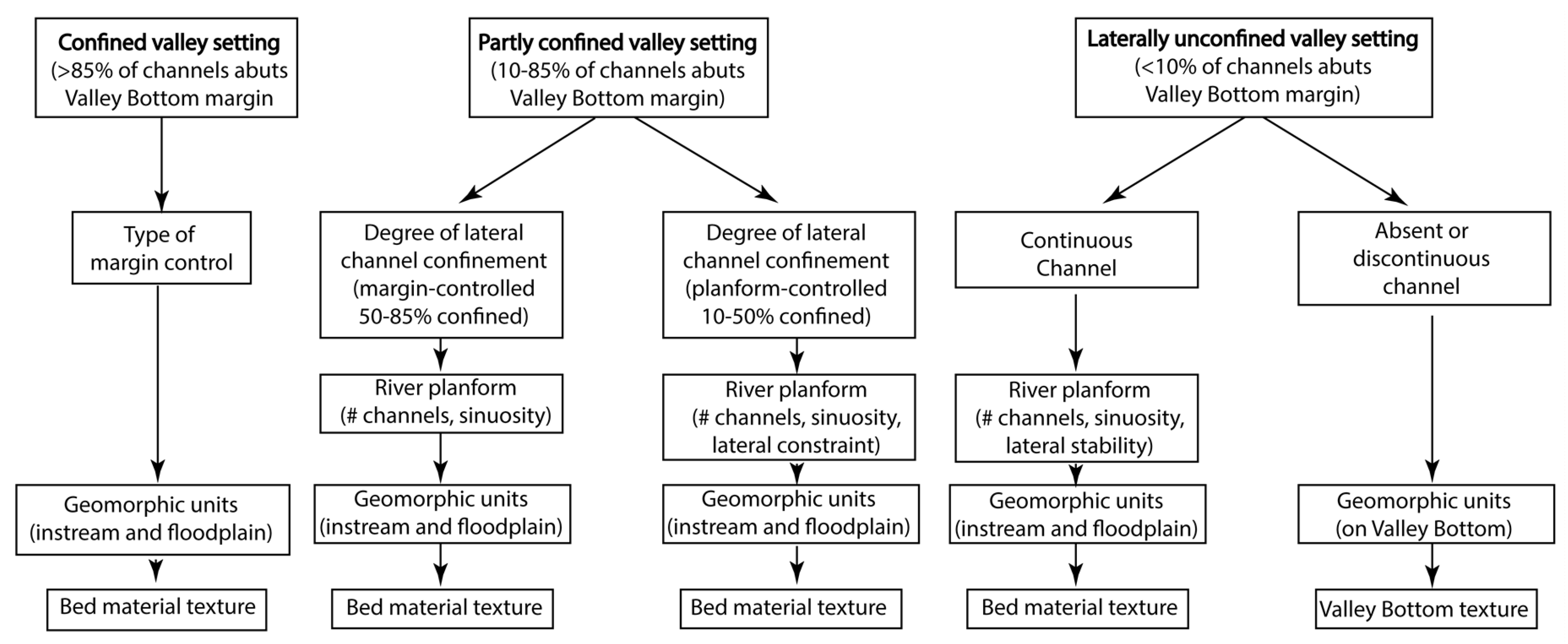
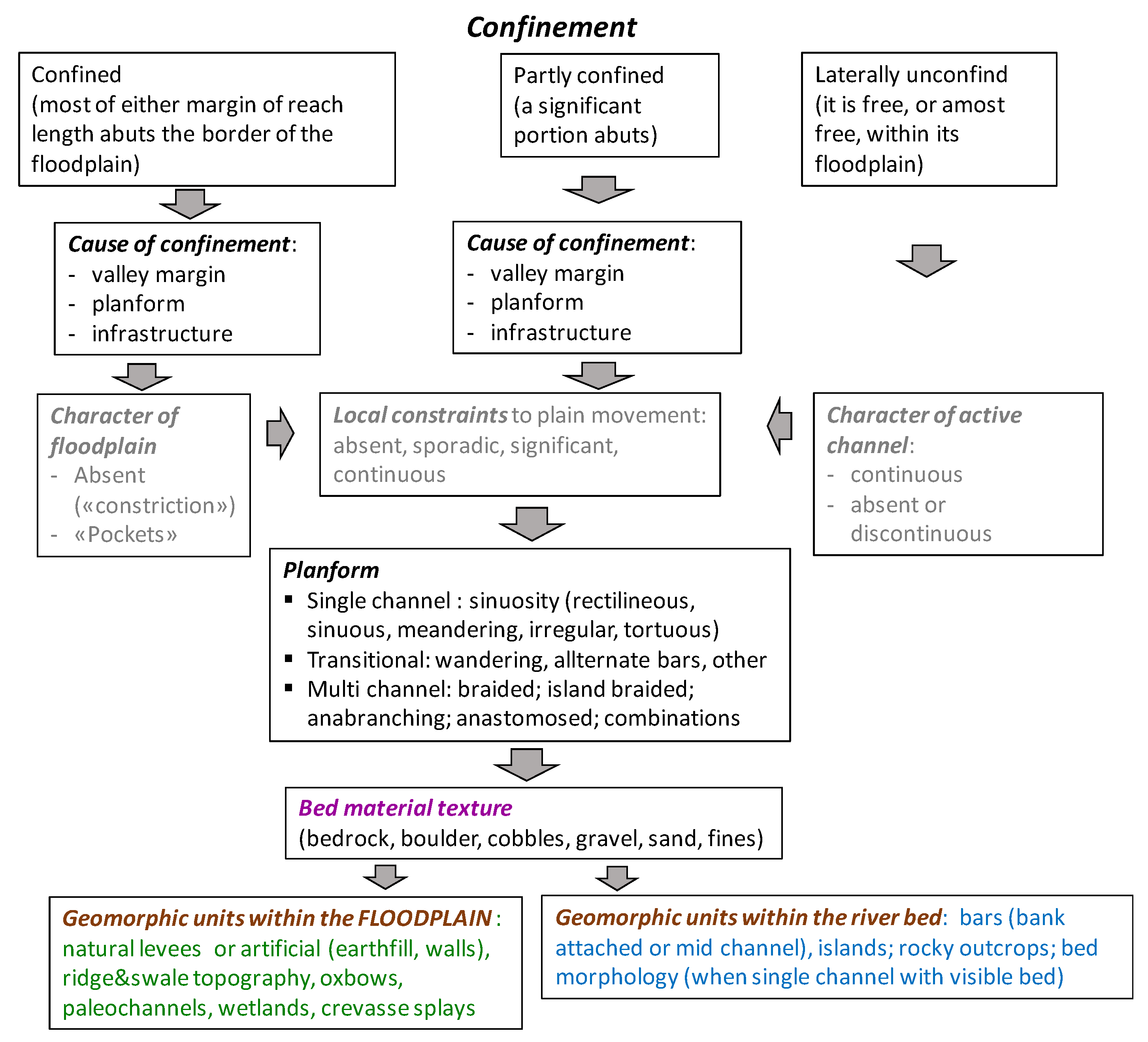
2.1.1. Procedural Tree

After an analysis and characterization at the river basin scale to identify particularly the controls of river behavior (e.g. geology, tectonic, relief, lithology, valley shape and slope), the pivot of the whole RS Framework is the “procedural tree” which drives the characterization and classification stage. The most recent version proposed by the original authors [6] is shown in Figure 1.
To make the tree more adherent to the actual RS methodology itself and more easily implementable by computer aided tools, we made some changes (Figure 2).
First, we considered ahead what counts more, that is, when a synthetic characterization of any river reach is presented, according to the River Styles Framework practice [6], essentially only the following fundamental attributes are considered: confinement, cause of confinement (when relevant also continuity of channel and floodplain continuity) and particularly planform and bed material. These are priority, synthetic descriptors of the character of the reaches. Other attributes, although present in the procedural tree ahead (in particular geomorphic units), are therefore postponed in our tree. This may seem an irrelevant change but actually is a major one because, without it, one would see the generation of an enormous number of styles, unless subjective judgement is introduced, which is what we want to avoid at this stage.
Second, for all the attributes of the type “presence/absence within a reach” (like the occurrence of geomorphic units or the frequency of contacts between the active channel and the valley bottom margin that generate confinement), we compute a statistical indicator over each reach (for binary attributes: frequency—i.e., from “absent” to “complete”; while for categorical: prevalence—i.e., max presence of a category over the others in terms of numerosity within the reach). This is another innovation we introduced to avoid the subjectivity in discerning whether the presence of some typology of geomorphic units generates new River Styles.
Third, we dropped the assumption that a 50–85% confinement implies a margin controlled situation while, below that, it is a planform situation; in such a way, more generality is granted (the assumption was introduced as a first approximation to interpret results of an automated algorithm that was not able to discern between the two situations explicitly).
Lastly, we dropped the distinction based on lateral stability (for the laterally unconfined case, continuous channel) because it constitutes derived information. Lateral stability in fact can be inferred—as suggested by Kleinhans and van den Berg [7]—by considering the planform type (based on sinuosity and anabranching features), the geomorphic units (presence of levees and absence of bars) and/or when there is a context of low energy and fine floodplain sediments, as well as directly from the scarcity of movement (multitemporal analysis). However, the planform type and the presence of geomorphic units is already considered explicitly in the dedicated attributes of the procedural tree (the floodplain sediment texture and energy level are not), while a multitemporal analysis rather belongs to the time evolution investigation that is treated in an explicitly dedicated separate step.
The procedural tree presented in Figure 2 does not claim to be fully general, as it was explicitly conceived for the Magdalena basin, but the novelties introduced are general and with minor adaptation the tree can certainly apply to other cases. Additionally, it can be noted that vegetation does not appear explicitly, although its key role in influencing geomorphic dynamics is well recognized in the literature and even addressed in management (e.g., Piégay et al. [8]); the RS Framework is no exception when it comes to interpreting river behavior. The reason for its absence in the procedural tree is basically that it goes “hand-by-hand” with the characters explicitly considered; this to say that a given planform, for instance, cannot occur without the appropriate vegetation for that climatic, pedogenetic, hydrologic, biologic, geomorphic context. A further articulation of the procedural tree including explicitly some vegetation character may however deserve consideration in an improved version.

2.1.2. Attributes

In principle, all the attributes considered in the adopted procedural tree (Figure 2) have to be assessed. Another novelty we introduced is that some (few) of them are labelled core attributes (in general not coinciding with the “fundamental” ones indicated above in Section 2.1.1) because they directly come into play to identify the river reaches, being independent from reach length (this point is explained in Nardini et al. [9]). All other attributes, which depend on the reach length, are then determined as statistic measures over the already identified reaches (what, incidentally, resembles very much what was done by Lewin and Ashmore, [10]).
For the Magdalena River, these core attributes were: (1) planform; (2) bed material texture (sediments); and (3) water surface type. The latter is a surrogate of bed morphology, mostly invisible in “turbid rivers” like the middle and low Magdalena, where water is particularly turbid all the time.

2.1.3. Classification Algorithm

The RS classification is performed in two hierarchical levels, while respecting the new procedural tree, by using the results obtained in the previous phase. This is another methodological innovation introduced. The first level (“RS_main”) is based on the “fundamental attributes” confinement, cause of confinement, planform and sediments (see Section 2.1.1). Although the first two do not contribute to generating the reaches (as they are derived as statistic measures on reaches predefined via the core attributes), they do play a key role in characterizing the river reaches. The second (final) level (“RS_full”) includes the remaining attributes, namely: geomorphological units within the VB (i.e., levees, oxbows, ridge & swale, paleo channels and wetlands) and geomorphological units within the active channel (i.e., bars LAT, MED, islands and water surface type), plus the resulting code (a kind of new attribute) from the first level. This exercise can be accomplished by applying a GIS grouping algorithm originally developed by TNC and adapted to this purpose that, differently from the ArcGIS version, is able to perform an exhaustive identification (GeoMagda Toolbox, Nardini et al. [3]); in simple words, it just looks for all the different combinations occurring in the database created and labels them according to the procedural scheme adopted.

2.2. Synthesis of the Information

According to the original RS Framework, in order to get an understanding of river character and behavior, a river basin scale map (or, to avoid confusion, a set of maps at the same scale) is produced where the main controls are reported (geology, relief, faults, lithology, landscape units, valley bottom width and type of boundaries, lateral constraints, constriction, etc.); virtually in the same map, but physically in another map at the same scale, main characters of the river are reported, like the macroscale confinement and bed sediment texture and in another one the collection of River Styles identified. This river basin scale view is complemented by a synoptic graph illustrating the main attributes: valley bottom elevation (and slope), area of contributing basin (linked to the position of tributaries), stream power (total and specific), valley bottom width, active channel position and representative planforms (and cross sections). At the reach scale, more details are added through a specific form (“Proforma”). A further detailed scale can be approached, which of course would add insight but only by field surveys or higher resolution remote sensed data (e.g., Columbia Habitat Monitoring Program—CHaMP project: https://www.champmonitoring.org/, lastly visited on 27 March 2020). With this wealth of preorganized information, it is possible to elaborate a first interpretation of river behavior, a step requiring expert judgment and as such it is not automatable.
As already indicated, further steps are envisaged by the original RS Framework, like the analysis of the historical evolution and the search for spatial patterns of RSs along the hydrological network, but in this paper we concentrate on the characterization and classification stage, applied to the main river only, because here is where we introduced some novelties, as explained above, and where data and project limitation led us for the moment.

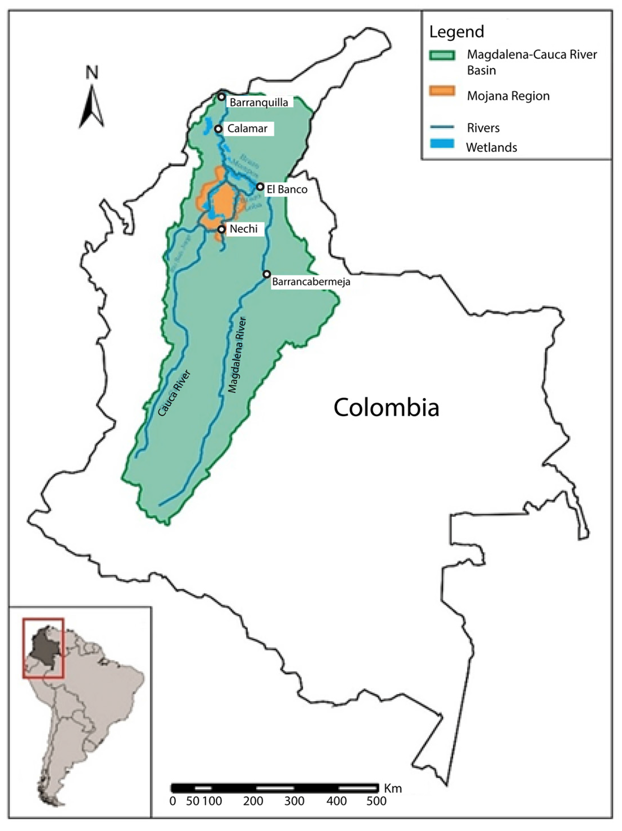
3. Application to the Magdalena Case

The Magdalena Basin (Figure 3) is the most important basin in Colombia, covering with its 271 thousand km2 almost 24% of the country. The basin supports water provision, food security and other services to more than 70% of the Colombian population [11]. It is also the heart of the national energy system with 60% of current national hydropower capacity of the country [12]. Unfortunately, a number of adverse processes during the last century have been affecting this basin [13], and the future envisages an even darker scenario. Climate change is expected to rise the level of the Caribbean Sea by some 3.5 mm/year. The rainfall patterns characterizing this area, including El Niño and La Niña (ENSO) phenomena, are assumed to progressively change, resulting into longer and harsher droughts and more intense/frequent flood events [14]. This very probably will significantly affect important cities, such as Barranquilla. In addition, land use has been profoundly changed in the Magdalena River Basin by population growth, involving somewhat uncontrolled deforestation and urbanization and industrial as well as illegal mining development. This has resulted in an increment of the sediment load [15,16] and, more recently, of the load of wastes and toxic compounds to the rivers linked to gold mining in particular [17,18]. Moreover, many heavy interventions included in the political agenda are added to the list of on-going and future causes of negative impacts on the basin. These interventions include among others the construction of perhaps 50 new dams (several hypothesis exist mainly based on the old study by DNP, [19]), levees, groynes, rip-rap protections and gabions in several river sectors aimed at controlling floods and fluvial dynamics; the morphological resectioning of several “caños” (i.e., natural or seminatural relatively short channels connecting water bodies) to ease the evacuation of flood waters within exploited areas of the Mojana region (a large depression characterized by wetlands); the extensive and continuous dredging and construction of bank defenses to ensure the commercial navigability along a potential 900 km of the Magdalena River; as well as the construction of new roads.
Experience demonstrates that most of these interventions very often activate a never-ending “vicious circle” of expenditures (and corruption), works and modification of geomorphic response, impacts that affect the whole river network, eventually implying much higher expenditures than initially planned [20].
Aware of this frightening future and of the national and worldwide trend to go along this path of growing anthropogenic impact [21], some of us carried out a project named GeoMagda [3] whose main objective was to foster the adoption in Colombia (and elsewhere) of the River Styles Framework [1] geomorphological approach to contribute to a more balanced and sustainable river basin planning and management in a context of climate change. The methodology presented here is actually an output of that project.
In what follows we shortly explain how all attributes have been assessed for the Magdalena case, independently whether “core” (those involved in the defining reaches boundaries) or “fundamental” (the most important ones in the procedural tree) or “other”.
Planform
A first segmentation of the river axis was performed by distinguishing single and multithread segments. This was done by using a GIS algorithm that discretizes the whole valley bottom in “fine subsections” (by using the Fluvial Corridor Toolbox of Roux et al., [22]) and then determines and analyzes the intersection between islands & bars polygons and the active river bed (available from official national SHP (shapefiles) files of the national Colombian institute for maps drawing “Instituto Geografico Augustin Codazzi-IGAC” at 1: 100,000 scale). The segments, neither clearly single nor multi, were assumed to be “transitional”. Then, for single thread segments, their sinuosity was determined as the ratio between river axis and valley bottom axis lengths and a final planform classification was obtained; namely: (1) straight, (2) sinuous, (3) meandering, (4) tortuous). For transitional or multithread segments, an expert judgment assignment to one planform category was performed based on a visual analysis of the SHP active river bed and Google Earth images (at a 1:10,000 ÷ 1:50,000 scale); the categories are: (i) transitional (a-wandering, b-alternate bars or c-‘swallowing’), (ii) braided, (iii) island braided, (iv) anabranching, (v) anastomosed (We introduced this typology which is quite frequent in the Magdalena River to identify a situation where the river gets sporadically significantly wider locally with one or few large islands as if it were a “digesting snake”. We interpret it, analogously to the island braided one, as characteristic of tropical environments where harsh floods—associated to heavy sediment load—are quite infrequent with respect to the speed of vegetation growth, so that after a short lasting situation with mid channel bars and various active channels, bars are rapidly vegetated and somehow stabilized -until the next strong flood), plus combinations (see [23]). Several difficulties had to be faced. In particular, a difficulty arose from the time shift between the official SHP files available (active channels, bars) and Google Earth imagery and/or bad image quality. In another paper [24], an innovative procedure is presented which aims to be “expert-judgment exempt”.
Bed material texture (“Sediments”)
Since river bed information is highly dispersed amongst different public and private institutions, we relied on qualitative information gathered in the field between December 2018 and January 2019, from San Agustin to Magangué (Figure 3). As the Magdalena is a “Turbid River”, data refer to bars or islands which were the only visible elements. In addition, we used qualitative information from the national Colombian institute for water Instituto de Hidrología, Meteorología y Estudios Ambientales -IDEAM [25] and Ordoñez & Deeb [26]. The occurrence of a recognized type of bed material texture along a stretch was extrapolated until a different value was found. We are aware that all of this is a weakness of the data base and hence bed material texture must be considered just first attempt information.
Water surface type
This attribute was introduced as a proxy of river bed character (generally not visible because of water turbidity) and was determined by expert judgment by visual observation of Google Earth imagery at a scale of 1:5000–1:10,000 approximately. The categories considered (partly arbitrary, but fully described in Nardini et al., [3]) were: (0) water fall; (1) step and pool or cascade; (2) rapids; (3) pool and riffle; (4) plane surface; (5) corrugated (intermediate between rapids and pool and riffle, with large riffles one after the other, not ending in a pool); (6) streamed, with visible current thread; (7) rippled, similar, but less marked; (8) not detectable, because of bad quality of images. Based on this analysis, a SHP line of uniform segments was created. Afterwards, a reductionist-holistic exercise was carried out to eliminate segments shorter than a significant length (10 river width); this GIS-Excel algorithm decides which reaches should be merged into a single reach and which categorical values should be assigned to it [24].
It must be noted that this attribute is affected by ambiguities because of the flow rate (which should always be at least comparable and hence scaled amongst reaches, while it certainly was different even amongst images of the same reach and not always appropriate to ascertain flow character), the time of the day (the illumination changes significantly altering the perception) and the angle of the satellite with respect to the river and the cloudiness; the adoption of this attribute was actually more of an experiment than a consolidated decision.
Geomorphological units
Amongst the geomorphological units within the floodplain (FP onwards) we considered: (1) levees, (2) wetlands, (3) paleo channels, (4) oxbows and (5) ridge and swales topography. They were detected by visual inspection of Google Earth imagery and expert judgment, complemented by some official IGAC SHP (e.g., for wetlands) and qualitative information reported in IDEAM [25]. Within the active channel, we considered median and lateral bars and islands. Bars were identified by IGAC in an official SHP, whereas the latter were identified through a GIS algorithm (i.e., “envelope of active channels within the active river bed minus active channels, which include bars”). After the identification of these elements, by intersection with the segmented Valley Bottom (VB; by using the Fluvial Corridor Toolbox of Roux et al. [22]), we obtained a binary “presence/absence” (1, 0) indicator in each discrete “subsection”. Finally, we computed a statistical indicator over each reach (for binary attributes: frequency—i.e., from “absent” to “complete”; while for categorical: prevalence—i.e., max presence of a category over the others in terms of numerosity within the reach). This is another innovation we introduced to avoid the subjectivity in determining whether a given typology of geomorphic units is or is not significantly present within a reach.
Confinement and its cause
These very important attributes for the RS characterization (actually they lie in pole position in the original procedural tree of Figure 2) were determined afterwards through a specific, articulated procedure. First the Valley Bottom (VB onwards) was identified (based on the Fluvial Corridor Toolbox tool plus manual refinements). Then we identified the reaches (as explained in Nardini et al. [9]). Afterwards, we developed and applied an original GIS-Excel algorithm for confinement including “cause of” (shortly presented in Nardini et al. [24]) which yields a categorical value for both confinement degree and its cause for each reach.

4. Results for the Magdalena Case Study and Discussion
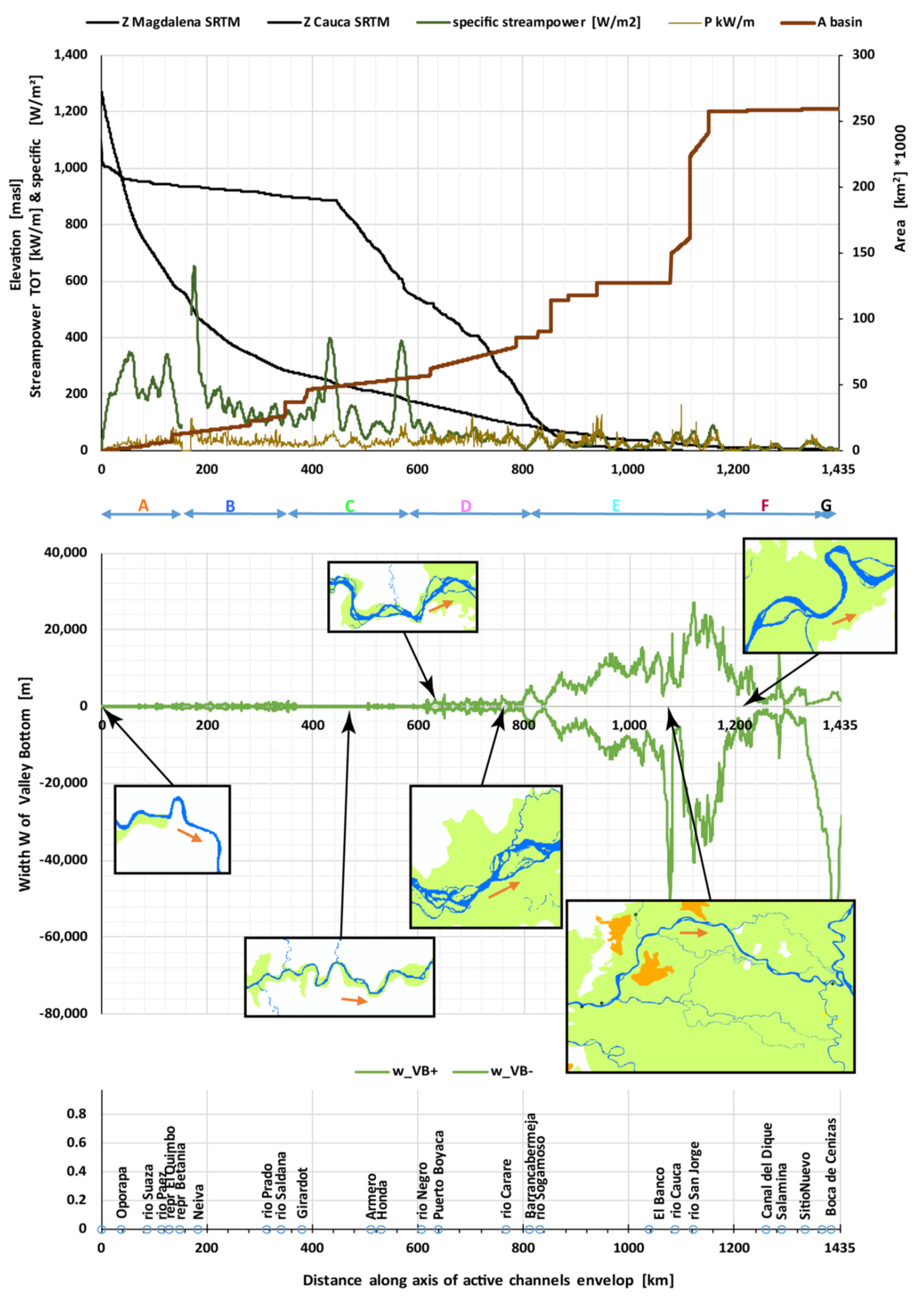
It has to be remembered that the value of the Magdalena case-study, rather than in the characterization of the specific river considered, lies in illustrating a structured information basis set up in an automatized (or at least automatable) fashion for a large river. This basis allows a useful reading of river character and behavior by looking at the river at different scales all together, i.e., the essence of the River Styles approach. It can be observed that techniques and methods like those mentioned in Piégay et al. [2] are very valuable and can provide equivalent or more illuminating information. However, the River Styles Framework—systematized through our approach—provides a basic, very integrated, holistic characterization that can hardly be found elsewhere.
To illustrate this idea, according to the methodology previously explained, we present results mainly at the basin scale and then (in the Supplementary Material) an example at the reach scale, where the River Styles are actually analyzed.
Notice further that our analysis starts where official data are available and hence the very first part of the river—about 50 km together with the famous “Estrecho del Magdalena”—is not included (Figure 4).

4.1. Basin Scale

4.1.1. Generalities

The Magdalena River slope is high (about 1%) in the first stretch considered; significant (about 1 ÷ 3 per 1000) until almost Girardot (Figure 4), low to very low (about 0.1 ÷ 1 per 1000) until the Mojana area and virtually zero afterwards (after 1100 km approx.). Contrary to what visual perception on the ground would suggest, the floodplain is almost nonexistent for a large stretch (i.e., from the beginning until almost Barrancabermeja: Figure 3), i.e., the river is significantly entrenched. The floodplain is large (but less than what would appear at first sight from a basin map), just in the middle part of the river (namely at the Mojana Region). Curiously, along the last stretch, again the floodplain is almost negligible, until the very delta (which in reality is mostly disconnected from the river by defenses along the right bank). The river basin is quite elongated with an overwhelming contribution from the Cauca River only (this is why the basin is often called “Magdalena-Cauca” basin) not long before the end of the river (at almost 80% of the total length). The specific stream power (Ω = ρgQs/w, where Ω (W/m2), with ρ: density of water (kg/m3), g: gravity acceleration (m/s2), Q: flow rate (m3/s), s: bed slope (m/m), w: active channel total width (m)) is on average medium to high (around 200 W/m2) approximately until Girardot, where it presents a peak around 400 W/m2 analogously as at Honda (Figure 5), corresponding to a local narrowing of the valley; and it presents quite low values elsewhere (around 40 W/m2), until the very flat Mojana plain (Figure 3) where it lowers to typical values of anastomosed reaches. The blunt change of direction of the river towards west-southwest occurring at El Banco (where conventionally the Lower Magdalena Basin starts) seems to be associated to a local, low, but marked relief (a Messinian conglomerate and lytic sandstone or San Lucas gneiss) seemingly working in fact as natural groyne, together with the significant input of the Cesar River through its wide Zapatosa Wetland (of course, tectonic history should be analyzed in depth for a full understanding; see for instance Martinez et al., [27]). That is the only reach with a significant macro scale sinuosity and within that area the river is clearly anastomosed. Once exiting the wide floodplain and receiving the end of its own long anastomosed branches, the Magdalena River shows a partly confined setting (from reach T4). Later, it follows with an island-braided planform—although much less marked than upstream reaches—until its mouth, where it deposits its giant solid load [16] feeding coastal deposits and a large subareal fan with submarine canyons and landslides dynamics [28].
It should be remembered that, traditionally, the upper river ends at Honda (rather than Girardot), because the local “Salto de Honda” (river rapids) blocked the upstream navigation. The traditional middle river is from Honda to El Banco, where we find an important hydrometric measurement station. Finally, the Lower Magdalena is from El Banco to Barranquilla, although from the end of the large floodplain (Calamar), the river is actually quite different (Calamar is where the famous semiartificial lateral navigable branch “Canal del Dique” starts leading to Cartagena, since the XVIth century when the Spaniards started its construction to ensure a commercial outlet to Cartagena). It is worth noting that the lowlands of the Mojana are filled with permanent or ephemeral wetlands extremely important from an ecological and economic point of view related to fishery [29].

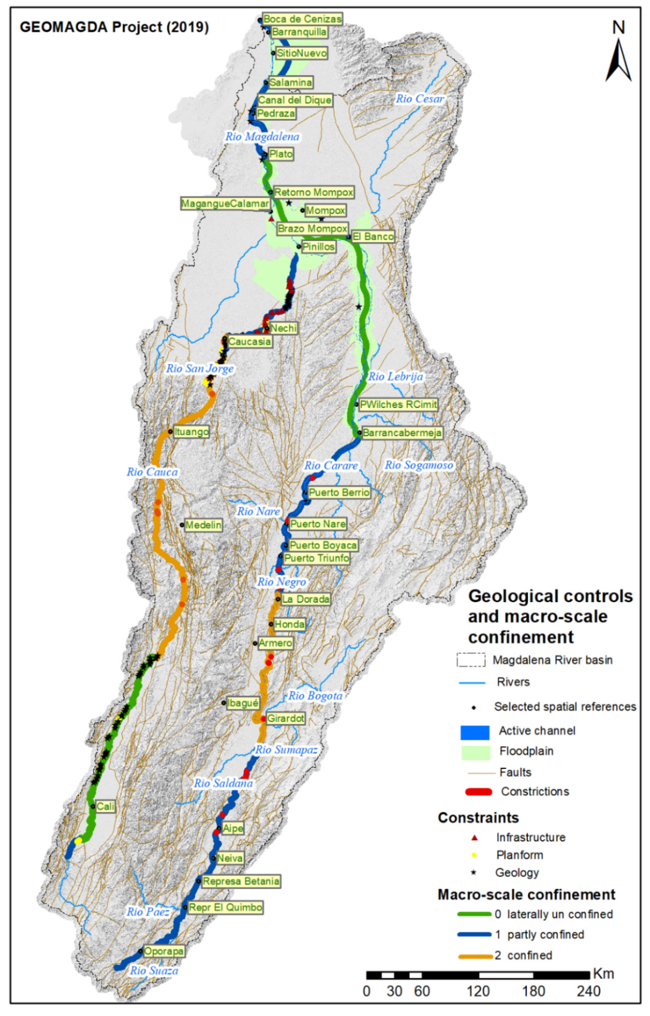
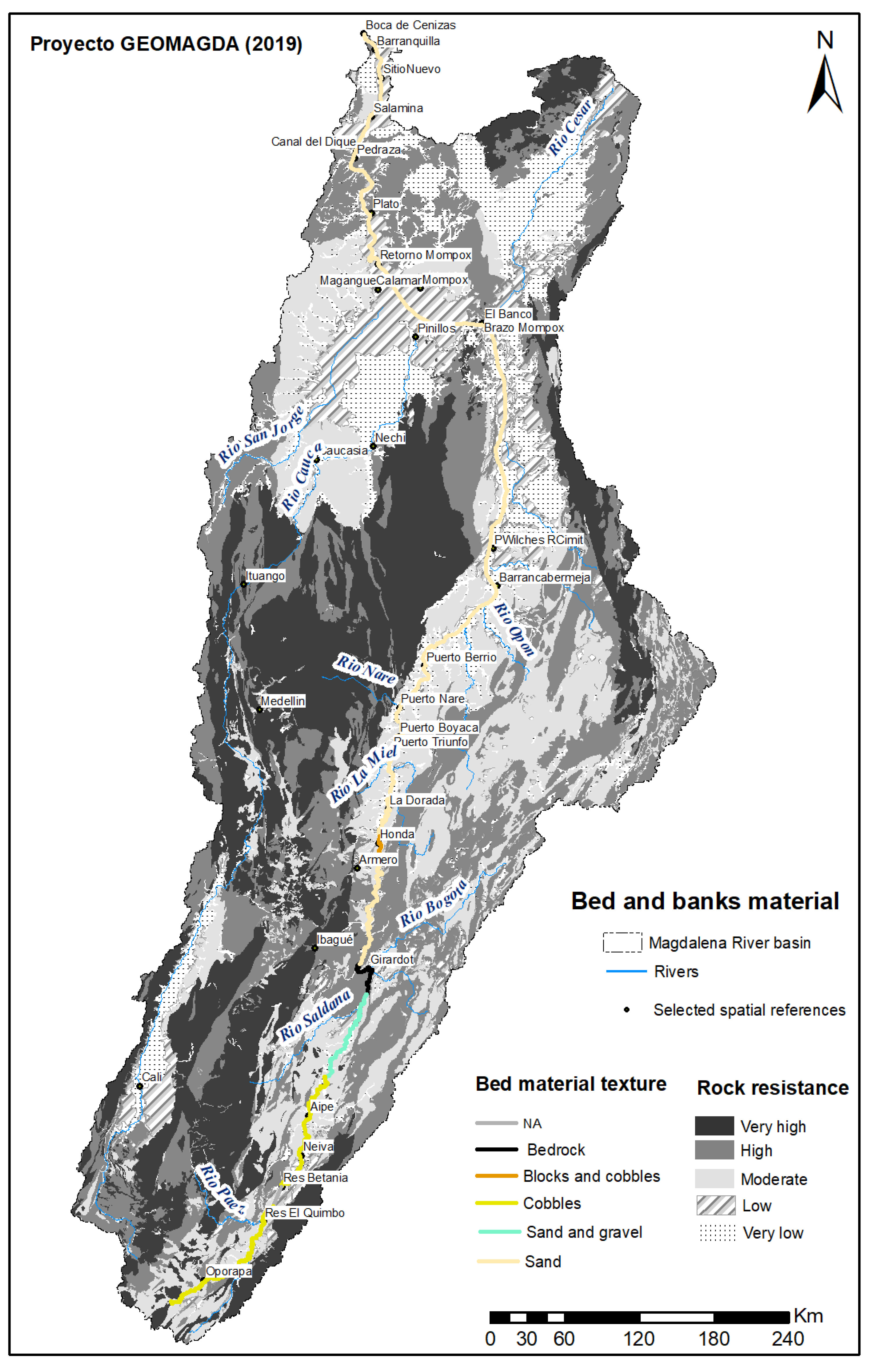
4.1.2. Controls and Characters at the Basin Scale

Figure 6, Figure 7 and Figure 8 illustrate in a synthetic, visual fashion, the main controls and some macro characters of the basin and its main rivers Magdalena and Cauca. Figure 6 shows the physiographic context, the geological faults, the main constraints, the Valley Bottom and the confinement degree at macro scale. Figure 7 gives an idea of the type of surface formations and deposits across the basin as well as the sediments within the river (although with low reliability). The synoptic scheme of Figure 8 provides an overall view of key attributes either as a long profile or as a plain view from which contributing basin area, slope and streampower can be appreciated.

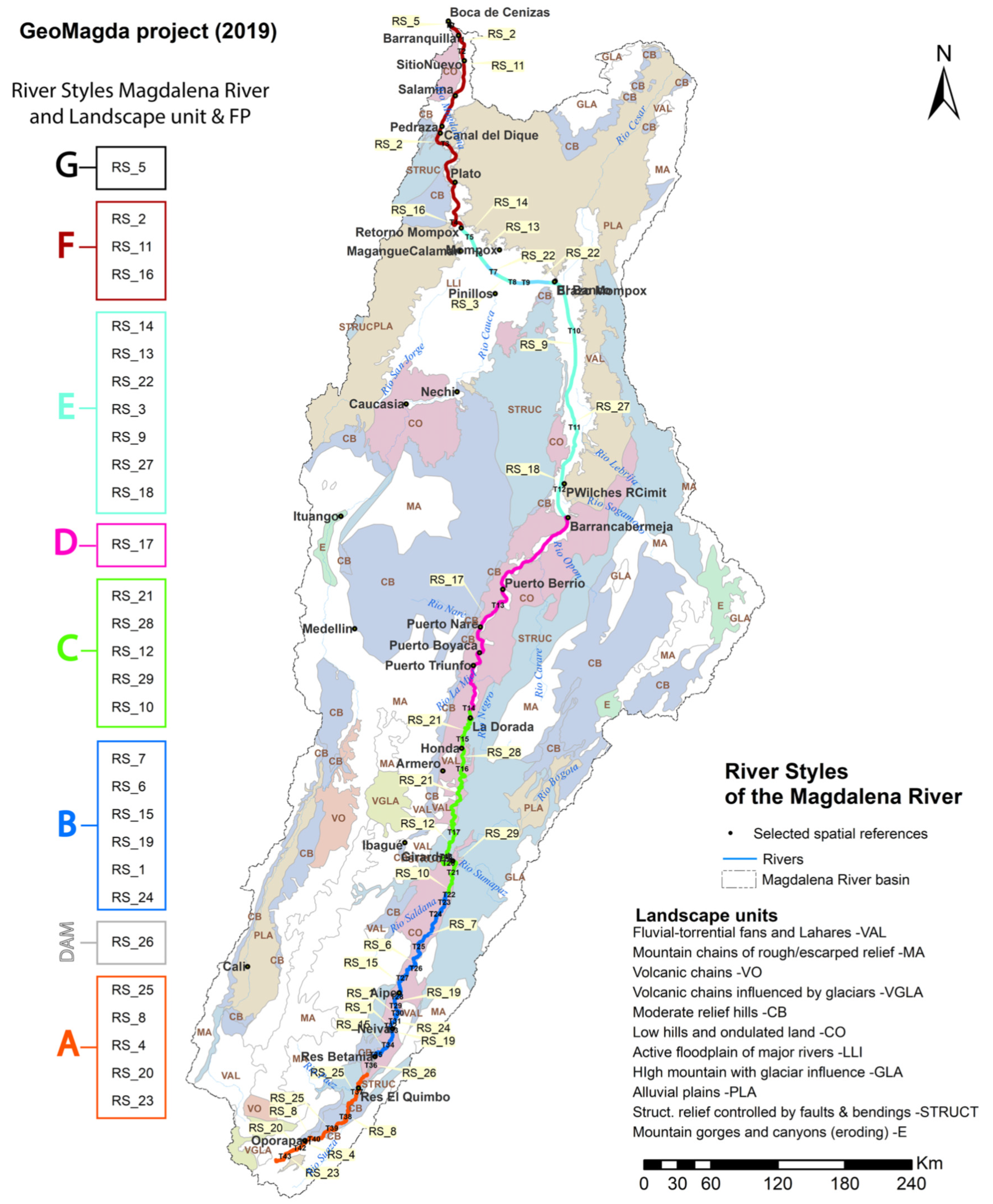
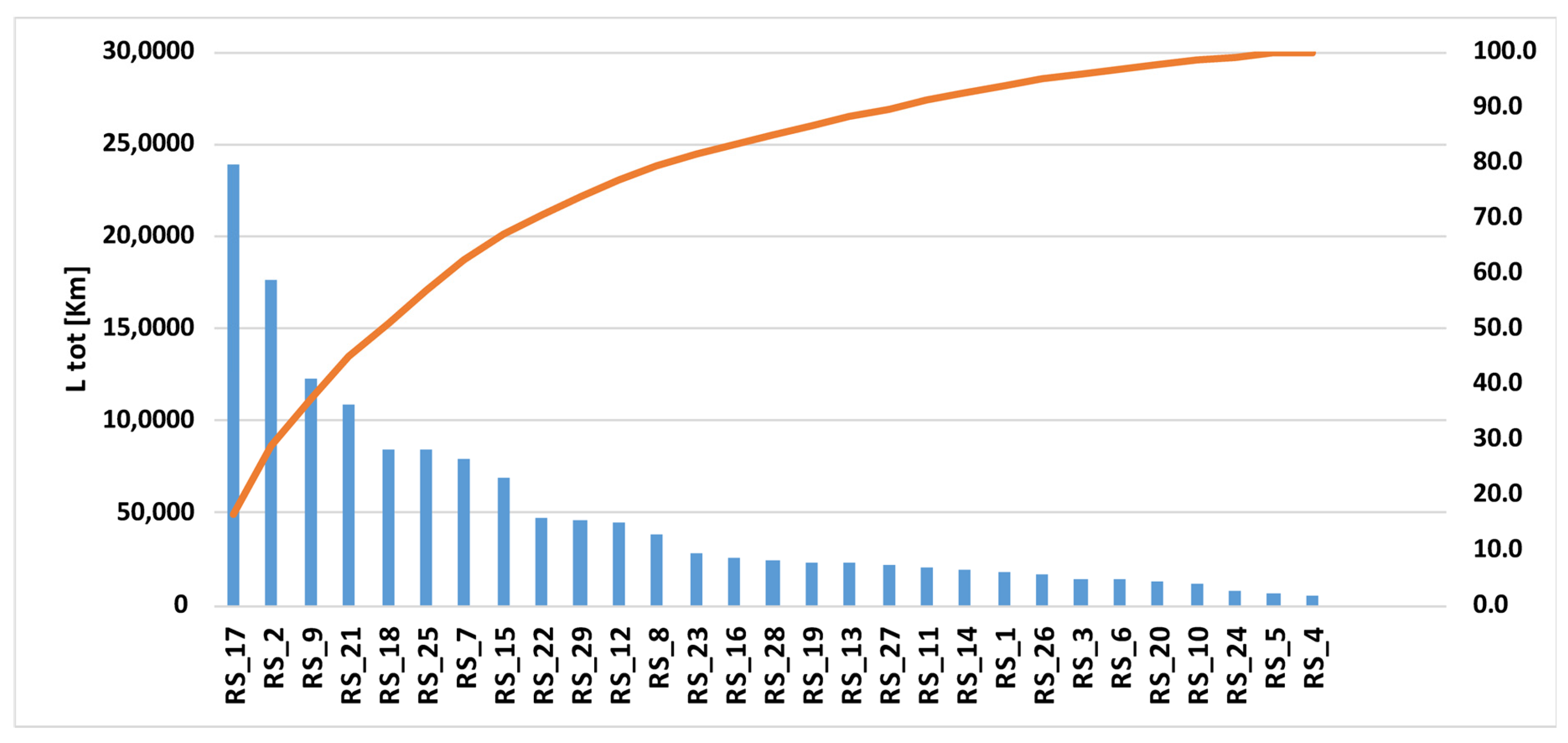
4.1.3. River Styles at the Basin Scale

Table 1 offers a very synthetic description of the RS classification obtained; the main characters are resumed, statistically, in Table 2. Additionally, Table 3 shows in summary form the main groups of RS found in the Magdalena River. Then, Figure 9 shows the spatial occurrence of the different styles, while Figure 8 points out the main ones based on the length of occurrence. As apparent, the upper part (until Honda approximately, reach T15) presents the highest diversity of styles. In the lower part, namely between El Banco and Mompox, the different styles are mainly linked to the presence of an anastomosed river whose main arm in turn presents a variety of configurations. A more compact denomination is used to group River Styles that accrue to a river stretch considered to behave in a somehow characteristic fashion (see Figure 8 and Figure 9 and the following discussion on river behavior at the basin scale).
The occurrence of River Styles according to their length is shown in Figure 10: Twelve RS cover about 80% of the total length.

4.1.4. River Behavior at the Basin Scale

Based on the information conveyed by the RS characterization, it is possible to infer the following behavior resumed in Table 3 above (very precious indications on how to conduct this type of reasonings is presented in Brierley et al. [30]. (Note that our analysis begins where official data are available and hence the very first part of the river—about 50 km—is not included).
Along the entire stretch until about 600 km there is a floodplain; however, it is very narrow and discontinuous and, as such, has no effects in terms of deposition, flood peak reduction downstream or recharge of the aquifer. Actually, the whole partly-confined stretch (Figure 6) and the confined reaches (i.e., from just before Girardot until La Dorada; see also Figure 8 for orientation), characterize a sediment source zone. In this area the river gets loaded with important bed load, in addition to the ever-present suspended load. This occurs particularly where specific streampower is more than moderate (i.e., over 100 W/m2, which occurs upstream of La Dorada).
In the first stretch, the rapids (or cascade) bed morphology, generally controlled by rocky outcrops, characterizes the first 50 km of this source zone, witnessing a supply-limited transport (threshold river) with bedload regime, similarly to the Estrecho del Magdalena reach (Figure 6), but with an alluvial bed with frequent rocky outcrops. According to Table 1, no bars are present until 500 km, while specific streampower is significantly high (200–600 W/m2); hence, transport could still be supply limited until there (type A in Table 3). The presence of some terraces might confirm this by indicating a process of incision of the valley; however, their age has not been checked to confirm that they are not much older. However, the absence of bars evidently contradicts reality (see Figure 11); we conclude that several bars have been overlooked in the official SHP files and some have been rather classified as islands. Accordingly, already from 64 km, approximately, the river is more likely to present a transport limited, bedload regime—coherently with its transitional planform; this statement, however, is not based on actual data; therefore, the whole first stretch until the Betania Reservoir is considered as type A (Table 3).
A significant load contribution comes from the multiple tributaries: Suaza, Paez, Saldaña, Sumapaz and Bogotá (Figure 6), occurring between 97 and 436 km. Further investigations should analyze the grain size of bed sediments longitudinally to better understand their role.
From 187 km until 400 km approx. (i.e., from Neiva to Girardot), the river still lies in a low hills and undulated landscape unit with a narrow floodplain. It is mainly confined, anabranching, with coarse sediment. This is a sediment transfer zone, with a capacity limited, bed transport regime (type B in Table 3).
From 400 km approximately until 634 km (i.e., from Girardot to Rio Negro), the river still lies in a low hills and undulated landscape unit with a narrow floodplain, sometimes missing (like in Girardot or Honda). It is confined by former alluvial deposits, with mainly a single-thread (sometimes “swallowing”) planform, coarse sediment texture (mainly sand) but also a bedrock stretch near Girardot. This is a sediment transfer zone, with a capacity limited—and locally competence limited (see Figure 5)—bed transport (type C in Table 3).
From 634 km until approximately 870 km (Barrancabermeja), still in a low hills and undulated landscape unit, the river, confined by former alluvial deposits, presents a multithread, “island braided” planform, with presence of macro islands (Figure 12). This reach has a specific streampower almost always lower than 100 W/m2. A temporary deposition of sediments (sand) occurs within the channel with the formation and successive reworking of islands while fines are deposited within the floodplain, which is continuous and starts to be significant. The river hence presents a mixed regime, with a transport limited, bed load component (type D in Table 3).
From approximately 870 km (Barrancabermeja) until approximately 1206 km, an important floodplain appears which further downstream becomes very large. In addition, marked and soon continuous natural levees, accompanied by wetlands (particularly at the border with the Mojana area) are present. It is there that the Magdalena River exhibits the most important depositional zone both for suspended solids (fine to very fine) and bedload (sand that originates bars and islands), very similar to the lower Orinoco River in Venezuela [31]. Furthermore, it is in this area that the physical configuration of the river and its floodplain are extremely articulated with its full set of geomorphic units including different types of wetlands and depressions, connecting channels of all shapes, etc. supporting an actual “biodiversity farm” (type E in Table 3). This reach is indeed governed by important, periodic water exchanges between the river and large wetlands through established, natural connection channels—a very well-known dynamic that governs local fishery [32,33]—but also overbank flows associated with the levees building dynamics. According to Restrepo [15], who developed a sediment budget, the river here suffers coherently a significant loss of sediments. It is characterized also by sporadic occurrence of crevasses—plays and associated creation of new branches mainly due to an excess deposition of sediments within the current active channel followed by a period of high flows. Actually, from 873 km until approximately 1206 km, the river is multithread, anabranching. The avulsive events, however, are not that frequent and particularly the main stem presents an elevated stability (anastomosis) ensured by the levees themselves and the quite low specific streampower (Figure 13). According to Kleinhans and van den Berg [7], the virtual absence of bars does not witness an absence of bedload transport, but rather the inability to allow for lateral movement capable of creating an actual meandering path, so that sediments cannot be trapped in point bars but are rather flushed away along the river or into the floodplain.
The important load of sediments into the floodplain and its consequent accumulation (of about 4.54 mm/y in the last 2500 years, [34]), however, seems not to be accompanied by a rise of the floodplain elevation, probably because of an ongoing, large scale subsidence process [34,35,36,37] and possibly reinforced by a tectonic process [27]. Therefore, although this zone can be defined as “flood basin prominent” according to Lewin and Ashworth, [10] (Table 2), the behavior they describe in general for this planform typology (not specifically for this area) is as follows: “…the valley bottom is dominated by ponded water, with limited overbank sedimentation from a relatively stable channel. Aggradation may involve organic fills or vertical accretion…”; this may be more associated to the subsidence process than to a limited sedimentation. Local inhabitants and fishermen from the Zapatosa wetland and Mompox branch of the Magdalena state that—according to their direct experience—the bottom of river channels and wetlands themselves is significantly rising. It is impossible, based on the elements available now, to conclude whether this is an objective reality and whether it is due to a natural process of the current configuration of the basin, to the furious deforestation that occurred in the last half century [15], to the famous and dramatic event of the eruption of the Nevado del Ruiz in 1985 [26] or to a mix of causes.
From 1206 km (the exit from the Mojana Region) until approximately 1429 km (the beginning of Barranquilla city), the river lies in moderate relief hills landscape unit, with a significant but discontinuous FP. It is partly confined, mainly single-thread, with a plethora of planform types from anabranching, meandering, “swallowing” and straight, very fine sandy bed texture, with dunes whose wave lengths change according to flowrate (personal communication by prof. Manuel Alvarado). It is highly dynamic, with several geomorphic units within the floodplain. It is a sediment depositional zone within the FP, with a capacity limited, mixed regime (type F in Table 3).
The last reach is characterized by a low hills and undulated landscape unit and a moderate to narrow discontinuous FP. Here the river is confined by valley flanks and works; it is single-thread, with a sinuous planform and a fine sediment texture (D50 →63 μm, with dunes with variable size according to the flowrate -Manuel Alvardo, personal communication). This is a sediment depositional zone within the FP, with a capacity limited, mixed transport regime (type G in Table 3). It has to be noted that there used to be flood channels and caños connecting the main river [38] to the giant wetland “Ciénaga de Santa Marta” and the former active delta area to the north until the open sea, but they have been closed and only minor connections exist, controlled by gates. Even the river bed migration is in large part blocked by longitudinal protections in the central zone of Barranquilla and long marine cutwaters.

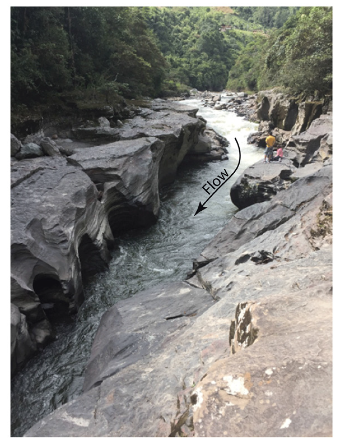
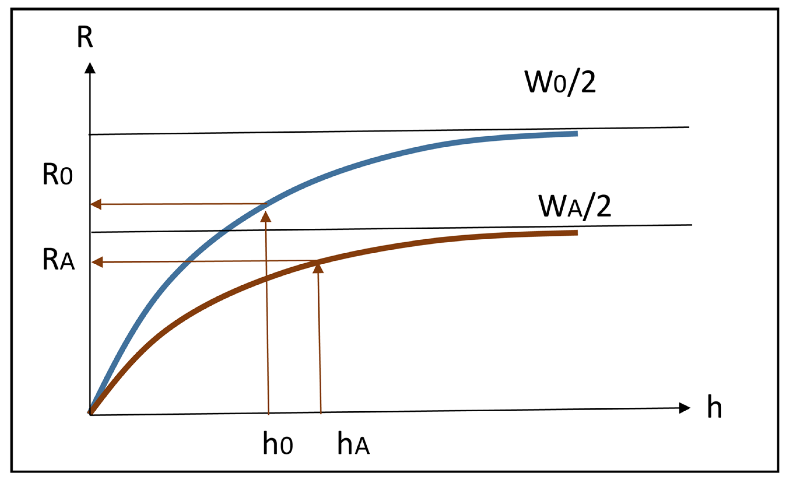
4.1.5. Why Anabranching?

Why should the river “choose” a multithread setting? Given a flow Q, a single channel configuration displays a higher bedload transport capacity than a multichannel configuration with the same total width and same slope s. This is shown analytically in Appendix A and it was confirmed by lab experiments by Jansen and Nanson [39] and the observations of Abbado et al. [40]. Indeed, in the narrower and deeper channels, with a lower hydraulic radius R, friction occurs over a wet area proportionally larger, so that the shear stress τ at the boundary (τ = γ R s, being γ the specific weight of water) is lower and even lower, accordingly, is the bed load capacity (see Appendix A). When, however, the multichannel configuration [41] includes less sinuous channels (say pseudo-straight)—rather than a meandering, and hence longer, single channel reach—the situation is quite different. In agreement with Jansen and Nanson [39], the narrower and deeper channels also show a higher slope (because they are shorter) and hence higher velocities. In such conditions, in correspondence of the bankfull flow of the single channel, the set of multiple channels carries a higher bed load, although their total bankfull flow is lower. This means that, in such conditions, a (significant) part of the flow that in the single channel would carry the highest expected bed load is rather overbank flow (depositing fine sediments in the floodplain).
The Magdalena River presents a plethora of diverse situations that appear ensuring its adaptability to a wide range of flowrates and sediment inputs:
  • For relatively frequent, low to moderate flowrates (including bankfull), and relatively low to moderate (but, on average, the largest fraction of the yearly input) coarse solid load input from upstream and local catchment (from fans, laminar erosion, etc.), the anabranch channels just carry the incoming bedload (plus the suspended load), with no overflow nor significant deposition or erosion;
  • For infrequent, very high flowrates and associated very high solid input (from landslides, mass block failure, avalanches, debris flows, gully erosion of valley slopes and sub catchments)—the anabranching configuration displays a total hydraulic and bedload transport capacity lower than that of a wider, single channel configuration with similar slope. Therefore, a large part of overbank flow occurs on the floodplain, in a corridor along the main channel (“lit majeur”) with frequent deposition of coarse suspended material along banks (and associated accretion of levees), together with deposition of finer sediments in farther zones of the floodplain;
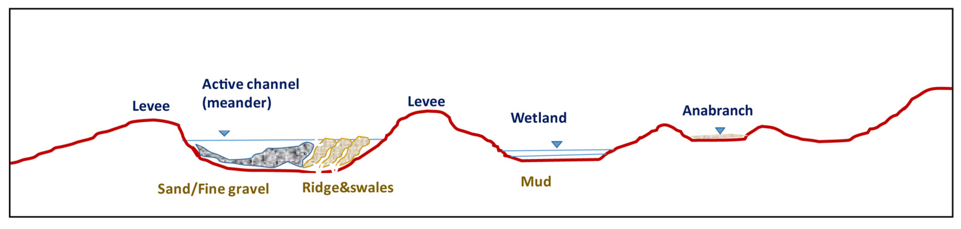
  • The tendency to assume a multibranch configuration originates in the waning stage of these high floods, when important quantities of the coarser fraction of solids are deposited, so contributing to the formation of bars and islands. These are rapidly vegetated and, in the following high flood, will trigger the opening of new channels into the floodplain, hence cutting off the immense islands that characterize it;
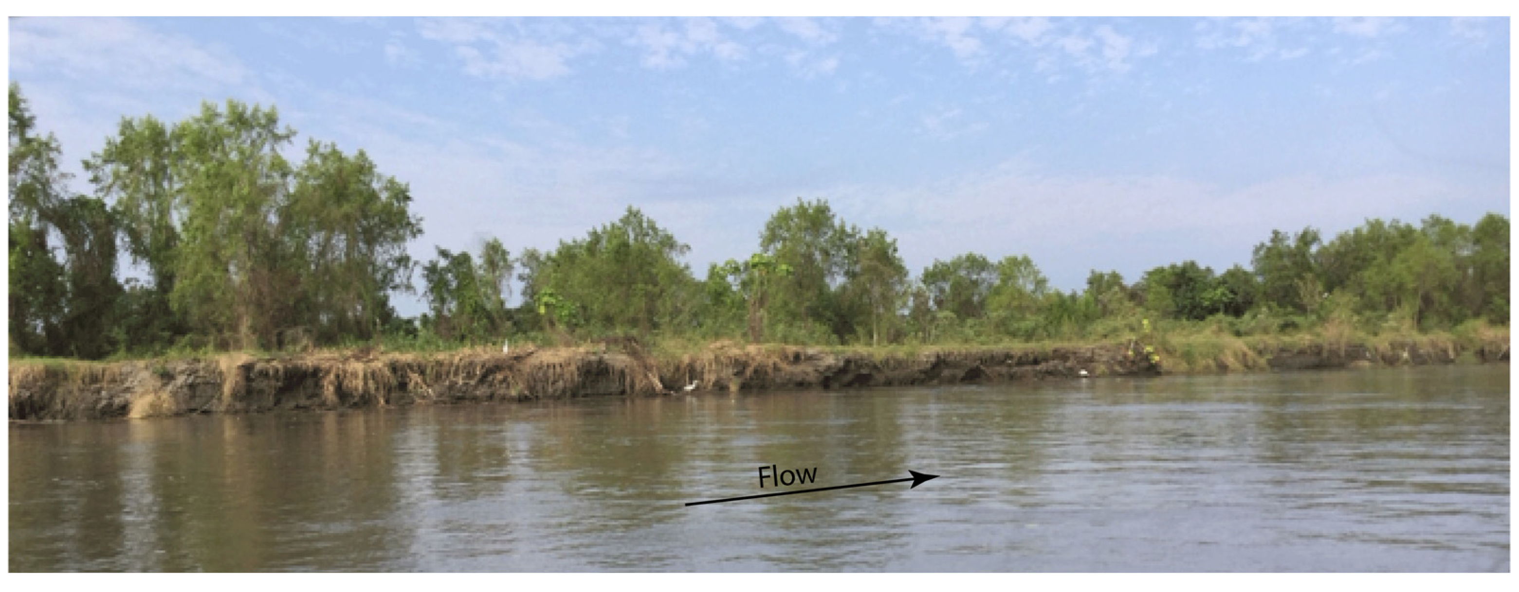
  • Within the floodplain itself, several mechanisms contribute to the formation of smaller lateral channels (caños). For instance, the drainage of rainfall waters can concentrate in a slightly lower point of the plain, quickly transforming it in an outlet towards the river so creating the embryo of a new channel. Vice versa, in other points, water in one of the main channels can overtop its levee creating a breech, or a bank failure may occur because of a local landslide possibly triggered by a tree fall: in both cases, a sudden opening of a new channel may occur. At the same time, channels may progressively get clogged by sediments typically at their intake, and a filling process starts from successive flooding by deposition of fine sediments, while new ones are created or enlarged.
In all such processes, vegetation, very dynamic in these tropical environments, plays an important role by rapidly colonizing and stabilizing large bars and sometimes impeding the formation of migrating meanders (actually, a ridge and swale topography is quite rare in the main channels); moreover, the very levees constitute a kind of guide that can be modified only in quite rare and dramatic events.

4.2. Reach Scale

At the reach scale, there is the collection of proformas, one for each River Style. In Supplementary Material, as an example, we present just one for reach T30 in Figure S1.

4.3. Discussion

The process developed for the Magdalena River was not exempt from difficulties and the assessment of attributes still is affected by high uncertainty and imprecision (The whole process implied very lengthy and tedious stages. For instance, we had to manually identify new elements due to the lack of certain required information (e.g., levees); the river network definition was not straightforward given the difficulties in using automatized tools with too rough DEM -like the SRTM 30 m adopted; the overwhelming number of shapefiles and raster created obliged us to a careful management and clear naming of all of them, which becomes extremely heavy when several rivers are to be analyzed; and several steps implied several switches of information between GIS and Excel which is not straightforward. Although full automation still needs to come, it is fully possible. In another paper [24], we provide hints to overcome several of such difficulties). Additionally, it has to be remembered that our analysis begins where official data are available and hence the very first part of the river is not included. More importantly, the exercise should be conducted for all tributaries within the basin, while the GeoMagda project (at a demonstration level) only approached the Magdalena and its main tributary, the Cauca River and as such we could not yet approach the search and interpretation of patterns of River Styles along the hydrological network (an interesting experience is presented by Liébault et al. [42]).
All this together indicates that the results obtained are to be considered just a first level approximation definitely to be improved and we actually identified two improvement pathways, one “easy” and the other “more demanding” discussed below. One of the limitations we faced in our analysis is the incomplete, unreliable and unsynchronized nature of the information used. For instance, we obtained (approximated, primary proxy) data for the bed material (actually bars material) just for the Magdalena; consequently, we could not apply exactly the same procedural tree to both the Magdalena and Cauca Rivers (and to others) which prevents us from making thorough comparisons.
In the short run, a relatively “easy” pathway of improvement envisages a coordination effort to gather the existing information about, in particular, sediment texture (a very important attribute): governmental bodies, universities, municipalities, all count with very valuable information, sufficient to have a reliable, complete assessment of that attribute. Analogously, other attributes could be completed, refined or added. Unavoidably, once something is changed, all the following sequential steps are to be run again, like the updating of the river “skeleton” (discretization in fine subsections with all the values of the core set attributes), the definition of reaches, the updating of the reaches geo-database, the calculation of statistic indicators for the noncore set attributes and the RS classification itself. Then, the corresponding maps, graphs and statistics have to be updated. Another important step is the elaboration of all the proformas (see Supplementary Material) for the emblematic reaches, that it is not an easy task, because they resume a lot of information, even not directly produced within the RS (e.g., the bankfull flow).
In the longer run, a “more demanding” pathway of improvement would contemplate the application of the methodology to the whole set of relevant rivers within the basin, rigorously with the same procedural tree, i.e., with the same attributes assessed with homogeneous and synchronous information (as source, resolution, time).
Thinking of other large rivers, adopting more refined DEMs would be highly advisable, although this does not mean jumping to LIDAR or decimetric precision datasets: metric resolution is sufficient, otherwise the computational burden might be unbearable. It is however important to ensure sufficient time coherence between the imagery utilized (e.g., Google Earth Images or aerial photos) and the altimetry information (DEM), otherwise serious inconsistencies occur, starting from the automated delineation of the river network. Another important point is that, no matter the size of the basin considered, the identification of geomorphic units (bars, wetlands, etc.) has to be carried out with sufficient detail to see them, otherwise the whole framework fails.
It is clear that field data alone are insufficient to tackle complex geomorphic questions for large rivers: remotely sensed data are needed (although these need in turn field observations for validation [2]). Recent progress in remote sensing has enhanced spatial resolution (reaching submetric scales), while collecting simultaneously multispectral and radar information and in some cases (such as Pleiades) stereoscopic datasets for topographic/DEM reconstruction; additionally, the frequency of acquisition has increased (subweekly acquisition) [2]. These technological advances can be used to identify from scratch the key elements (active channel, bars, wetlands, oxbows, etc.), possibly by exploiting data fusion techniques [43], even with LANDSAT images [44], possibly with a GEOBIA approach [45]. Future integration of different sensors (optical, hyperspectral, LiDAR, SAR, etc.) into a modulable, methodological framework would also be advisable to this aim [2].

5. Conclusions

From a methodological point of view, we experienced, through the Magdalena case-study, that even for a large river basin with scarce/low-resolution information, the proposed methodology can lead to a meaningful River Styles characterization and classification. Moreover, the proposed methodology confines the expert-judgement inputs into well-defined steps (e.g., the choice of attributes, the procedural tree, and particularly in the behavioral interpretation) and, as such, leads to a more objective output. Finally, the application can virtually be fully automated, although in our “case-study” a significant manual input was required, as several tools and GIS-Excel procedures had not yet been programmed into packages. The proposed methodology is exportable to many other large river basins. Advanced techniques to identify from scratch the key elements (active channel, bars, wetlands, oxbows, etc.) can provide a substantial support, although field observations can also partly feed directly the proposed method (e.g., when assessing the river bed sediment texture). On the other side, improved logical or AI algorithms could be used to solve the “reductionist-holistic synthesis” problem, in particular to derive the planform or bed morphology automatically. A specific exercise should be dedicated to the reconstruction of the historical evolution which certainly requires a further coordination effort amongst institutions to collect a tremendous amount of consistent information.
It is important to remember that the characterization and classification constitute just a first stage within the River Styles Framework (to be carried out for all relevant rivers within the considered basin). Afterwards, one has to investigate the time evolution of the river morphology and likely future trajectories, to assess their “condition” (or “geomorphic health”) and the potential for recovery, and finally, based on this information, to prioritize interventions. In developing or emerging countries like Colombia, however, rather than “restoration” (although certainly required in many cases), the key policy should be focused on avoiding disruption, which is the most serious challenge, given the size and pace of anthropogenic changes. This is why we conceive the characterization and classification stage—together with the historical evolution (not discussed in this paper; an initial attempt is discussed in Nardini et al. [3])—as a knowledge starting point to monitor then how the geomorphic setting is going to change in time and even as a basis to predict what could happen to rivers in the future, if certain actions are going to be undertaken or not. This is the main usefulness of the approach proposed. Second, the understanding of how each reach behaves can of course support planning at finer scales, by identifying in particular the hazardous (more dynamic) reaches.
Coming to the specific application to the Magdalena River, we are aware that the work developed can only be considered a preliminary step and we actually identified two improvement pathways, one “easy” and the other “more demanding”, as explained in the discussion section.

Supplementary Materials

The following are available online at https://www.mdpi.com/2073-4441/12/4/1147/s1, Figure S1: Example of Proforma for reach T30 of the Magdalena River.

Author Contributions

Conceptualization, A.N.; methodology, A.N. and S.Y.; software, S.Y.; L.Z. and A.N.; validation, A.N.; S.Y.; C.G. and M.D.B.; formal analysis, A.N. and S.Y.; investigation, A.N. and S.Y.; resources, A.N. and S.Y.; data curation, A.N., L.Z. and S.Y.; writing—original draft preparation, A.N.; S.Y. and M.D.B.; writing—review and editing, A.N.; M.D.B.; C.G.; and S.Y.; visualization, L.Z. and S.Y.; supervision, M.D.B. and C.G.; project administration, A.N.; funding acquisition, A.N. All authors have read and agreed to the published version of the manuscript.

Funding

This research received external funding thanks to The Nature Conservancy through the “GeoMagda” Project, contract No. TNC-CREACUA NASCA 00162/2018.

Acknowledgments

We want to thank The Nature Conservancy who made this investigation possible through the project GeoMagda. We thank Gary Brierley and Kirstie Fryirs for inspiring this work with the River Styles Framework and participating in several fruitful discussions and debates and make clear that the responsibility for any mistake or misinterpretation is fully ours.

Conflicts of Interest

The authors declare no conflict of interest.

Appendix A. Two Channels

We consider here a single (rectangular) channel configuration with flowrate Q0, width w0, depth h0 and slope s and an alternative configuration where the flowrate is split into two parts (QA = QB = Q0/2) in two analogous (rectangular) channels (A, B) with same slope as the original one but narrower (wA = wB < w0).
We want to ascertain whether the bed load transport capacity is higher in the former (“single channel”) or in the latter configuration (“anabranching”). What follows aims just at answering this specific question, without pretention of predicting the morphology.
By hypothesis, hydraulically the two configurations carry the same total flowrate. We look for the resulting depth hA (for symmetry: hA = hB). From the Chezy-Strickler relationship (velocity V is a function of the parameter χ, the hydraulic radius R and the slope s):
V = χ (R s)1/2 with χ = c R1/6, c: Strickler’s smoothness coefficient,
Reminding that, by hypothesis, QA = Q0/2, and assuming for simplicity (without loss of generality) that wA = w0/2, we obtain:
hA(RA)2/3 = h0(R0)2/3,
By definition of the hydraulic radius R for a rectangular section of width w:
R(h,w) = h × w/(2h + w),
It is an increasing, monotonic function of h asymptotically tending to w/2 and increasing with w (Figure A1); therefore, for a given h, it always is RA < R0. From Equation (2), it must be:
hA > h0 (that is, a deeper channel, which is intuitive),
Figure A1. The hydraulic radius R(h,w) as a function of water depth (h) and channel width (w) for a rectangular channel.
Water 12 01147 g0a1
For solid transport we adopt (consistent with Henderson, [46]), the Einstein-Brown formula (Valid for sand and fine gravel, typical of large rivers and high levels of bedload in a given range of the dimensionless shear stress τ*, while for coarser sediments the exponent increases [47]. Indeed, the development here presented embeds a certain level of contradiction because we apply this formula to anabranching channels which, in general, might not satisfy such hypothesis; rigorously speaking, more suited formulas should be tested.) which provides the unit transport capacity qs as a function of the dimensionless shear stress τ* to the boundary and of a constant k (reminding that τ* = τ/[(ρS − 1) gD], with ρ: density of water, ρs: density of solid grains; g: acceleration of gravity, D: representative diameter of sediments):
qs* = k (τ*)3 → qs = k*(τ)3 (supposing that the grain size does not change),
QS = w qs = w × k*(τ)3 = w × k*(γ × R × s)3,
With this, we obtain the ratio of solid transport capacity in the two configurations (reminding that, by hypothesis, in the anabranching, for symmetry, it is double that of one of the two channels, i.e., QS,TOT = 2QS,A ):
QS,TOT/QS,0 = (RA/R0)3,
Notice that since hA > h0, it results RA < R0, otherwise Equation (2) would not be fulfilled. We can therefore conclude that:
QS,TOT/QS,0 < 1,
which demonstrates the initial statement.

References

  1. Brierley, G.; Fryirs, K. Geomorphology and River Management: Applications of the River Styles Framework; Blackwell Publishing: Malden, MA, USA, 2005. [Google Scholar] [CrossRef]
  2. Piégay, H.; Arnaud, F.; Belletti, B.; Bertrand, M.; Bizzi, S.; Carbonneau, P.; Dufour, S.; Liébault, F.; Ruiz-Villanueva, V.; Slater, L. Remotely sensed rivers in the Anthropocene: State of the art and prospects. Earth Surf. Process. Landf. 2020, 45, 157–188. [Google Scholar]
  3. Nardini, A.; Yepez, S.; Rogeliz, C. Caracterización Geomorfológica River Styles en la Cuenca del rio Magdalena: Caso estudio Magdalena y caja de Herramientas Para la Aplicación Automatizada a la Cuenca. GeoMagda ToolBOX; The Nature Conservancy: Bogotá, Colombia, 2019; Available online: https://www.researchgate.net/publication/338585128_Manual_GeoMAGDA (accessed on 1 February 2020).
  4. Brierley, G.; Fryirs, K.; Cook, N.; Outhet, D.; Raine, A.; Parsons, L.; Healey, M. Geomorphology in action: Linking policy with on-the-ground actions through applications of the River Styles framework. Appl. Geogr. 2011, 31, 1132–1143. [Google Scholar] [CrossRef]
  5. Brierley, G.; Fryirs, K.; dos Santos Marçal, M.; Lima, R. The use of the River Styles Framework as a tool to ‘work with nature’in managing rivers in Brazil: Examples from the Macaé Catchment. J. Rev. Bras. Geomorfol. 2019, 20. [Google Scholar] [CrossRef] [Green Version]
  6. Fryirs, K.A.; Brierley, G.J. What’s in a name? A naming convention for geomorphic river types using the River Styles Framework. PLoS ONE 2018, 13, e0201909. [Google Scholar] [CrossRef] [PubMed] [Green Version]
  7. Kleinhans, M.G.; van den Berg, J.H. River channel and bar patterns explained and predicted by an empirical and a physics-based method. Earth Surf. Process. Landf. 2011, 36, 721–738. [Google Scholar] [CrossRef]
  8. Piégay, H.; Ruffinoni, C.; Citterio, A.; Bourgery, C.; Caillebote, P. Guide Technique n° 1: La Gestion des Boisements de Rivieres,. Bassin Rhone Mediterranee Corse (FR). Fascicule 1: Dynamique et Fonctions de la Ripisylve. 1998. Available online: https://www.google.com.hk/url?sa=t&rct=j&q=&esrc=s&source=web&cd=1&ved=2ahUKEwiP6cGF2e7oAhUGVpQKHTV7Df0QFjAAegQIAhAB&url=http%3A%2F%2Fdoc-oai.eaurmc.fr%2Fcindocoai%2Fdownload%2F87%2F1%2Fguide-tech-1-f1.pdf_2031Ko&usg=AOvVaw3jnV4GmBh793FyOklrBoKR (accessed on 17 April 2020).
  9. Nardini, A.; Yepez, S.; Mazzorana, B.; Ulloa, H.; Bejarano, M.D.; Laraque, A. Geomorphic river characterization: A systematic, automated approach for river segmentation with case studies on the Magdalena River (Colombia) and on the Baker River (Chile). Water 2020. (submitted). [Google Scholar]
  10. Lewin, J.; Ashworth, P.J. Defining large river channel patterns: Alluvial exchange and plurality. Geomorphology 2014, 215, 83–98. [Google Scholar] [CrossRef]
  11. UTMMC. Strategic Plan for Magdalena-Cauca Macrobasin: Unión Temporal Macrocuencas Magdalena–Cauca y Caribe for Colombian Ministry of Environment; Ministry of Environment: Bogotá, Colombia, 2014.
  12. IEA. World energy outlook 2014; International Energy Agency: Paris, France, 2014. [Google Scholar]
  13. Zapata, J.P.; Diaz, J.; Garzonferreira, J.; Garcia, C. Fluvial fluxes into the Caribbean Sea and their impact on coastal ecosystems: The Magdalena River, Colombia. Glob. Planet. Chang. 2006, 50, 33–49. [Google Scholar]
  14. IDEAM. 2a Comunicación Nacional ante la Convención Marco de las Naciones Unidas Sobre el Cambio Climático (2nd National Communication for the un Convention on Climate Change); Ministerio del Medio Ambiente & PNUD, IDEAM (Instituto de Hidrología, Meteorología y Estudios Ambientales): Bogotá, Colombia, 2010. [Google Scholar]
  15. Restrepo, J.D. Los Sedimentos del río Magdalena: Reflejo de la Crisis Ambiental; Universidad Eafit: Medellín, Colombia, 2005. [Google Scholar]
  16. Restrepo, J.D.; Syvitski, J.P. Assessing the effect of natural controls and land use change on sediment yield in a major Andean river: The Magdalena drainage basin, Colombia. Ambio A J. Hum. Environ. 2006, 35, 65–74. [Google Scholar] [CrossRef]
  17. Alvarez, S.; Jessick, A.M.; Palacio, J.A.; Kolok, A.S. Methylmercury concentrations in six fish species from two Colombian rivers. Bull. Environ. Contam. Toxicol. 2012, 88, 65–68. [Google Scholar] [CrossRef]
  18. Olivero-Verbel, J.; Johnson-Restrepo, B.; Mendoza-Marín, C.; Paz-Martinez, R.; Olivero-Verbel, R. Mercury in the aquatic environment of the village of Caimito at the Mojana region, north of Colombia. Water Air Soil Pollut. 2004, 159, 409–420. [Google Scholar] [CrossRef]
  19. DNP. Estudio del Sector Energía Eléctrica: Inventario de los recursos Hidroeléctricos; Fondo Nacional de Proyectos de Desarrollo FONADE, Interconexión Eléctrica ISA, Sociedad Alemana de Cooperación Técnica GTZ.: Bogotá, Colombia, 1979. [Google Scholar]
  20. Nardini, A.; Idarraga, F. A Qualitative Hydro-Geomorphic Prediction of the Destiny of the Mojana Region (Magdalena-Cauca Basin, Colombia), to Inform Large Scale Decision Making. Resources 2016, 5, 22. [Google Scholar] [CrossRef] [Green Version]
  21. Grill, G.; Lehner, B.; Thieme, M.; Geenen, B.; Tickner, D.; Antonelli, F.; Babu, S.; Borrelli, P.; Cheng, L.; Crochetiere, H. Mapping the world’s free-flowing rivers. Nature 2019, 569, 215. [Google Scholar] [CrossRef] [PubMed]
  22. Roux, C.; Alber, A.; Bertrand, M.; Vaudor, L.; Piégay, H. “FluvialCorridor”: A new ArcGIS toolbox package for multiscale riverscape exploration. Geomorphology 2015, 242, 29–37. [Google Scholar] [CrossRef]
  23. Nardini, A. River Planform identification through an automatic logical-heuristic algorithm. J. South Am. Earth Sci. 2020. (submitted). [Google Scholar]
  24. Nardini, A.; Yepez, S.; Bejarano, M.D. Improvements in Computer-Aided Tools to Support Geomorphic River Styles Analysis. Geosciences 2020. (submitted). [Google Scholar]
  25. IDEAM. Geomorfología y Susceptibilidad a la Inundación del valle Fluvial del Magdalena. Sector Barrancabermeja -Bocas de Cenizas; Subdirección de Geomorfología y Suelos, IDEAM: Bogotá, Colombia, 2001. [Google Scholar]
  26. Ordoñez, J.I.; Deeb, A. Caracteristicas sedimentologicas del lahar del río Guali del 13 de noviembre de 1985 y sus efectos sobre el río Magdalena, Colombia. In Proceedings of the XII Congreso LatinoAmericano de Hidraulica –IAHR, Santiago de Chile, Chile, 25–30 August 2014. [Google Scholar]
  27. Martínez, J.I.; López, E. El sistema fluvial del Magdalena durante el Plioceno–Cuaternario: Contexto tectónico y escenario paleoclimático. Los Sedimentos del Río Magdalena Reflejo de la Crisis Ambiental 2005, 1, 101–112. [Google Scholar]
  28. Ortega, M.A. Río Magdalena, Navegación Marítima y Fluvial (1986–2008); Universidad del Norte: Barranquilla, Colombia, 2008. [Google Scholar]
  29. Fondo_de_Adaptación. Valoración Integral de la Biodiversidad y Los Servicios Ecosistémicos en el Núcleo de Once Municipios de la Región de La Mojana (Integrated Evaluation of Biodiversity and Ecosystem Services in the Área of Eleven Municipalities within the Mojana Región; Fondo de Adaptación: Bogota, Colombia, 2015. [Google Scholar]
  30. Brierley, G.; Fryirs, K.; Cullum, C.; Tadaki, M.; Huang, H.Q.; Blue, B. Reading the landscape: Integrating the theory and practice of geomorphology to develop place-based understandings of river systems. Progress Phys. Geogr. 2013, 37, 601–621. [Google Scholar] [CrossRef]
  31. Yepez, S.P.; Laraque, A.; Gualtieri, C.; Christophoul, F.; Marchan, C.; Castellanos, B.; Azocar, J.M.; Lopez, J.L.; Alfonso, J.J. Morphodynamic change analysis of bedforms in the Lower Orinoco River, Venezuela. Proc. Int. Assoc. Hydrol. Sci. 2018, 377, 41–50. [Google Scholar] [CrossRef] [Green Version]
  32. Jiménez-Segura, L.F.; Palacio, J.; Leite, R. River flooding and reproduction of migratory fish species in the Magdalena River basin, Colombia. Ecol. Freshw. Fish 2010, 19, 178–186. [Google Scholar] [CrossRef]
  33. López-Casas, S.; Jiménez-Segura, L.; Agostinho, A.; Pérez, C. Potamodromous migrations in the Magdalena River basin: Bimodal reproductive patterns in neotropical rivers. J. Fish Biol. 2016, 89, 157–171. [Google Scholar] [CrossRef]
  34. Hammen, V.D. Fluctuaciones holocenicas del nivel de inundaciones en la cuenca del bajo Magdalena-Cauca-San Jorge (Colombia). Geol. Norandina. 1986 10, 11–17.
  35. HIMAT. Proyecto Cuenca Magdalena-Cauca; Convenio Colombo-Holandés: Bogota, Colombia, 1977. [Google Scholar]
  36. Martínez, A. Subsidencia y geomorfología de la depresión inundable del río Magdalena. Actas Primer seminario sobre el Cuaternario de Colombia. Rev. CIAF 1981, 6, 319–328. [Google Scholar]
  37. Smith, D.G. Anastomosing river deposits, sedimentation rates and basin subsidence, Magdalena River, northwestern Colombia, South America. Sediment. Geol. 1986, 46, 177–196. [Google Scholar] [CrossRef]
  38. Alvarado, M. Personal Interview; Universidad de La Guajira: Riohacha, Colombia, 2020. [Google Scholar]
  39. Jansen, J.D.; Nanson, G.C. Anabranching and maximum flow efficiency in Magela Creek, northern Australia. Water Resour. Res. 2004, 40. [Google Scholar] [CrossRef] [Green Version]
  40. Abbado, D.; Slingerland, R.; Smith, N.D. Origin of anastomosis in the upper Columbia River, British Columbia, Canada. In Fluvial Sedimentology VII; Blackwell Oxford: Oxford, UK, 2005; Volume 35, pp. 3–15. [Google Scholar]
  41. Latrubesse, E.M. Patterns of anabranching channels: The ultimate end-member adjustment of mega rivers. Geomorphology 2008, 101, 130–145. [Google Scholar] [CrossRef]
  42. Liébault, F.; Lallias-Tacon, S.; Cassel, M.; Talaska, N. Long profile responses of alpine braided rivers in SE France. River Res. Appl. 2013, 29, 1253–1266. [Google Scholar] [CrossRef]
  43. Dalla Mura, M.; Prasad, S.; Pacifici, F.; Gamba, P.; Chanussot, J.; Benediktsson, J.A. Challenges and opportunities of multimodality and data fusion in remote sensing. Proc. IEEE 2015, 103, 1585–1601. [Google Scholar] [CrossRef] [Green Version]
  44. Monegaglia, F.; Zolezzi, G.; Güneralp, I.; Henshaw, A.J.; Tubino, M. Software Automated extraction of meandering river morphodynamics from multitemporal remotely sensed data. Environ. Model. 2018, 105, 171–186. [Google Scholar] [CrossRef]
  45. Demarchi, L.; Bizzi, S.; Piégay, H. Hierarchical Object-Based Mapping of Riverscape Units and in-Stream Mesohabitats Using LiDAR and VHR Imagery. Remote Sens. 2016, 8, 97. [Google Scholar] [CrossRef] [Green Version]
  46. Henderson, F.M. Open Channel Flow; Macmillan: New York, NY, USA, 1966. [Google Scholar]
  47. Schmidt, J.C.; Wilcock, P.R. Metrics for assessing the downstream effects of dams. Water Resour. Res. 2008, 44. [Google Scholar] [CrossRef] [Green Version]
Figure 1. The original River Styles procedural tree (Source: Modified from Fryirs and Brierley [6]; permission automatically granted by the journal policy).
Water 12 01147 g001
Figure 2. Structure of the modified procedural tree once specified for the Magdalena River. Bold is used to identify the fundamental attributes; bold grey attributes, although fundamental, were not considered in the Magdalena case because of lack of information or nonoccurrence. The plain text words just describe possible values of the attributes.
Water 12 01147 g002
Figure 3. Location of the Magdalena River basin (Colombia). In orange the Mompox depression (including the Mojana) characterized by a dense presence of large wetlands.
Water 12 01147 g003
Figure 4. The “Estrecho del Magdalena” (a confined, bedrock reach), just upstream of our starting point.
Water 12 01147 g004
Figure 5. The “Rapidos de Honda”. Big boulders were carried here by the Gualí Tributary in the dramatic event of the Nevado del Ruiz eruption (This was also observed by Ordonez et al. [26]); they do not belong to the bedload transport of the contemporary Magdalena.
Water 12 01147 g005
Figure 6. Tectonic and valley shape controls (confinement and constrictions) at the macro scale for the Magdalena and Cauca Rivers. The floodplain (Valley Bottom) also exists in several reaches but is not visible at this scale. Constraints to the lateral movement of rivers are shown only for the plain parts of the basin, where their blocking role is more peculiar.
Water 12 01147 g006
Figure 7. Sediments (actually material of bars and islands) and banks material at macro scale, Magdalena basin.
Water 12 01147 g007
Figure 8. Synoptic scheme of the Magdalena River (including long profile Z of the main tributary Cauca) with area (A) of the contributing basin. Total (P) and specific streampower (see definition in the text) has been computed with the Q2.33 flow, estimated from empirical relationships from literature; the value shown is the moving average with a 20 “subsections” window (each “subsection” is 500 m). Notice that this figure is schematic assuming the river flows from left to right, while in physical maps the lower stretch (within the Mojana Region) flows from East to West, i.e., in the opposite direction; small planform sketches are reoriented according to the figure convention.
Water 12 01147 g008
Figure 9. Map of River Styles (pale yellow background labels within the map) identified in the Magdalena River (smaller, black labels identify reaches). Their meaning is specified in a resumed form in Table 1. The capital letters on the left (A → G) summarize groups of River Styles characterized by a common behavior at macro scale, as detailed within the text (see Table 3 and Figure 8 for details).
Water 12 01147 g009
Figure 10. Distribution of River Styles of the Magdalena River based on their total length of occurrence (L tot). RS meaning is synthetically explained in Table 1.
Water 12 01147 g010
Figure 11. A Magdalena reach (120 km in Figure 8) flowing from left to right, located about 35 km upstream of the Betania dam, a few km downstream of Paez tributary. Mid channel, bank attached bars and even a large island (right) are visible. An influence from the downstream new El Quimbo Reservoir cannot be excluded; however, bars can also be found upstream.
Water 12 01147 g011
Figure 12. A channel of the Magdalena River close to Barrancabermeja. The land visible here is a macro island vegetated. Along the banks separating the channels from the floodplain, it is common to find dense, tall vegetation (trees); frequent woody debris are indeed present within the channels, often partly or fully buried by sediments.
Water 12 01147 g012
Figure 13. Representative section of a multichannel reach, showing the typical complexity.
Water 12 01147 g013
Table 1. River Styles of each Reach (Tx) and value of all relevant attributes obtained for the Magdalena River (only Betania Reservoir appears as the new one—El Quimbo—was not yet considered in the official SHP files adopted). Red color denotes fundamental attributes; while blue is used for the accessory attributes related to geomorphological units. The main River Styles (RS main) only consider the former, while RS full also includes the latter.
ReachRS MainRS CompleteDistance kmLength kmConfinementCause of Conf.Planform TypeBed mat. Text.LeveesRidge&SwalesWetlandsOxbowsPaleochan.Water SurfaceIslandsLAT BarsMED Bars
T0RS_5RS_5_1_11429.06.58Confinedvalley flankssinuoussandsignificantabsentcompleteabsentabsentplane surfaceabsentabsentabsent
T1RS_2RS_2_2_11403.725.33Partly confinedplanforms"swallowing"sandsignificantsignificantcompleteabsentabsentripplessignificantabsentabsent
T2RS_11RS_11_1_11383.320.36Lat. unconfined-straightsandcompleteoccasionalcompleteabsentprevailingripplesoccasionalabsentabsent
T3RS_2RS_2_1_11232.5150.82Partly confinedplanforms"swallowing"sandcompleteoccasionalcompleteoccasionalsignificantripplesprevailingabsentabsent
T4RS_16RS_16_1_11206.526.04Partly confinedplanformsmeanderingsandcompletecompletecompletecompletecompleteripplescompleteabsentabsent
T5RS_14RS_14_1_11186.619.91Lat. unconfined-anabranching & meanderingsandcompleteprevailingcompletecompletecompleteripplescompleteabsentabsent
T6RS_13RS_13_1_11164.022.59Partly confinedplanformsanastomosed & sinuoussandcompleteabsentcompletecompletecompleteripplescompleteabsentabsent
T7RS_22RS_22_1_11149.814.20Lat. unconfined-anastomosed & sinuoussandcompleteabsentcompletecompletecompletestreamedcompleteabsentabsent
T8RS_3RS_3_1_11135.514.28Lat. unconfined-anastomosed & meanderingsandcompleteabsentcompletecompletecompleteplane surfacecompleteabsentabsent
T9RS_22RS_22_1_21102.333.18Lat. unconfined-anastomosed & sinuoussandcompleteabsentcompletecompletecompleteplane surfacecompleteabsentabsent
T10RS_9RS_9_1_1979.5122.82Lat. unconfined-anastomosed & island braidedsandcompleteabsentcompletesignificantcompleteripplescompleteabsentoccasional
T11RS_27RS_27_1_1957.621.94Lat. unconfined-island braidedsandcompleteabsentcompleteabsentprevailingripplescompleteabsentsignificant
T12RS_18RS_18_1_1872.685.00Lat. unconfined-island braided & anabranchingsandprevailingabsentcompleteabsentsignificantripplescompleteabsentoccasional
T13RS_17RS_17_1_1634.0238.52Partly confinedplanformsisland braidedsandabsentabsentoccasionalabsentsignificantripplesprevailingoccasionalsignificant
T14RS_21RS_21_2_1594.839.24Confinedplanforms"swallowing"sandabsentabsentabsentsignificantoccasionalripplessignificantprevailingsignificant
T15RS_28RS_28_1_1570.823.98Confinedplanformsstraightboulders&cobblesabsentabsentabsentabsentsignificantripplesoccasionalabsentabsent
T16RS_21RS_21_1_1501.569.33Confinedplanforms"swallowing"sandabsentoccasionalabsentabsentcompleteripplessignificantoccasionaloccasional
T17RS_12RS_12_1_1467.234.28Confinedplanformsstraightsandabsentabsentabsentabsentsignificantplane surfaceabsentabsentabsent
T18RS_12RS_12_2_1456.610.62Confinedplanformsstraightsandabsentabsentabsentabsentabsentstreamedabsentabsentabsent
T19RS_29RS_29_2_2447.78.95Confinedplanformsstraightbedrockabsentabsentabsentabsentabsentstreamedabsentabsentabsent
T20RS_29RS_29_2_1436.011.61Confinedplanformsstraightbedrockabsentabsentabsentabsentabsentcorrugatedabsentabsentabsent
T21RS_29RS_29_1_1410.725.39Confinedplanformsstraightbedrockabsentabsentabsentabsentsignificantripplesabsentabsentabsent
T22RS_10RS_10_1_1399.111.55Confinedplanformsstraightsand&gravelabsentabsentabsentabsentcompleteripplesabsentabsentabsent
T23RS_7RS_7_1_3380.918.23Partly confinedplanformsanabranchingsand&gravelabsentabsentabsentabsentcompletenot detectablesignificantabsentabsent
T24RS_7RS_7_1_1349.731.15Partly confinedplanformsanabranchingsand&gravelabsentabsentabsentabsentcompleteripplescompleteabsentabsent
T25RS_7RS_7_1_2319.230.51Partly confinedplanformsanabranchingsand&gravelabsentabsentabsentabsentcompletenot detectablecompleteabsentabsent
T26RS_6RS_6_1_1305.513.73Confinedvalley flanksstraightcobblesabsentabsentabsentabsentcompletenot detectableoccasionalabsentabsent
T27RS_15RS_15_1_1271.833.68Partly confinedplanforms"swallowing"cobblesabsentabsentabsentabsentcompletestreamedsignificantabsentabsent
T28RS_19RS_19_3_1258.912.92Partly confinedplanformsanabranchingcobblesabsentabsentabsentabsentprevailingstreamedprevailingabsentabsent
T29RS_19RS_19_2_1253.45.51Partly confinedplanformsanabranchingcobblesabsentabsentabsentabsentabsentplane surfacecompleteabsentabsent
T30RS_1RS_1_2_1240.413.03Partly confinedplanformssinuouscobblesabsentabsentabsentabsentoccasionalplane surfacesignificantabsentabsent
T31RS_24RS_24_1_1232.87.56Confinedplanforms"swallowing"cobblesabsentabsentabsentabsentcompleteplane surfaceprevailingabsentabsent
T32RS_1RS_1_1_1227.85.03Partly confinedplanformssinuouscobblesabsentabsentabsentabsentcompleteplane surfacecompleteabsentabsent
T33RS_19RS_19_1_1223.04.79Partly confinedplanformsanabranchingcobblesabsentabsentabsentabsentcompleteplane surfacecompleteabsentabsent
T34RS_15RS_15_2_1197.925.10Partly confinedplanforms"swallowing"cobblesabsentabsentabsentabsentsignificantplane surfacesignificantabsentabsent
T35RS_15RS_15_3_1187.110.80Partly confinedplanforms"swallowing"cobblesabsentabsentabsentabsentabsentstreamedabsentabsentabsent
T36RS_26RS_26_1_1169.917.13 reservoir
T37RS_25RS_25_2_1118.051.89Partly confinedplanformswanderingcobblesabsentabsentabsentabsentoccasionalnot detectableoccasionalabsentabsent
T38RS_8RS_8_2_197.120.92Partly confinedvalley flankssinuouscobblesabsentabsentabsentabsentoccasionalpool & rifflesoccasionalabsentabsent
T39RS_25RS_25_1_164.532.63Partly confinedplanformswanderingcobblesabsentabsentabsentabsentsignificantcorrugatedoccasionalabsentabsent
T40RS_8RS_8_1_146.817.70Partly confinedvalley flankswanderingcobblesabsentabsentabsentabsentabsentnot detectableabsentabsentabsent
T41RS_4RS_4_1_141.15.67Confinedvalley flankswanderingcobblesabsentabsentabsentabsentabsentrapidsabsentabsentabsent
T42RS_20RS_20_1_127.913.18Confinedplanformssinuouscobblesabsentabsentabsentabsentabsentpool & rifflesabsentabsentabsent
T43RS_23RS_23_1_10.027.93Partly confinedvalley flankssinuouscobblesabsentabsentabsentabsentabsentrapidsabsentabsentabsent
Table 2. Occurrence (% of river length excluding Betania reservoir) of values of RS attributes adopted for the Magdalena River. The attribute “islands” is the output of the reductionist-holistic algorithm applied with a significant length of 5 km (the 100 indicates the summation of the single % values).
Confinement%Cause of Confinement%N. Channels%Bed Material%
Lat. unconfined23.4Valley slopes6.5Mono17.6Bedrock3.2
Partly confined56.8Planforms70.1Transitional34.2Boulders&Cobbles1.7
confined19.8Infrastructures0Multi Chann.47.1Cobbles21.3
100none23.4(reservoir)1.1Sand&gravel6.4
100 100Sand67.4
100
Planform%Water surface type%
Straight11.3Rapids2.4
Sinuous4.6Corrugated3.1
Meandering1.8Pool & riffle2.4
Wandering9.1Streamed6.4
Swallowing25.5Rippled65.8
Anabraching7.3Plane surface10.5
Anabranching & Meandering1.4Not detectable9.4
Island braided18.4 100
Island braided & Anabranching6.0
Anastomosed & sinuous4.9
Anastomosed & meandering1.0
Anastomosed & island braided8.7
100
%Ridge &SwalesNat. LeveesOxbowsWetlandsPaleo Ch.lsIslandsBars MEDBars LAT
Absent7860.368.843.510.114.859.375.5
Occasional17010.616.88.811.519.521.7
Significant1.82.211.4043.514.021.20
Prevailing1.46.0003.928.902.8
Complete1.831.59.239.733.730.800
100100100100100100100100
Table 3. Resumed version of encountered River Styles of the Magdalena River.
ReachRS mainD kmCodeLandscape Unit & Floodplain (FP)Description
T0RS_51429.0GLow hills & undulated land, moderate to narrow discontinuous FP.Confined by valley flanks and works; single-thread, sinuous planform, fine sediment texture. Sediment depositional zone within the FP, with a capacity limited, mixed transport regime.
T1RS_21403.7FModerate relief hills, discontinuous FP.Partly confined, mainly single-thread, with a plethora of planform types, sandy bed texture; highly dynamic; sediment depositional zone within the FP, with capacity limited, mixed regime.
T2RS_111383.3
T3RS_21232.5
T4RS_161206.5
T5RS_141186.6EAlluvial plain.Laterally unconfined, anastomosed with fine sand sediment texture, ubiquitous levees and large wetlands. Sediment depositional zone, with a capacity limited, mixed transport regime.
T6RS_131164.0
T7RS_221149.8
T8RS_31135.5
T9RS_221102.3
T10RS_9979.5
T11RS_27957.6
T12RS_18872.6
T13RS_17634.0DLow hills & undulated land, narrow but continuous FP.Confined by former alluvial deposits; island braided planform, coarse sediment texture (sand). Sediment transfer zone, with a capacity limited, mixed transport regime.
T14RS_21594.8CLow hills & undulated land, narrow FP, sometimes missing.Confined by former alluvial deposits; mainly single-thread (sometimes “swallowing”) planform, coarse sediment texture (mainly sand), but also a bedrock stretch near Girardot. This is a sediment transfer zone, with a capacity limited, bed transport regime.
T15RS_28570.8
T16RS_21501.5
T17RS_12467.2
T18RS_12456.6
T19RS_29447.7
T20RS_29436.0
T21RS_29410.7
T22RS_10399.1
T23RS_7380.9BLow hills & undulated land, narrow FP.Mainly confined, anabranching, coarse sediment, sediment transfer zone, capacity limited, bed transport regime.
T24RS_7349.7
T25RS_7319.2
T26RS_6305.5
T27RS_15271.8
T28RS_19258.9
T29RS_19253.4
T30RS_1240.4
T31RS_24232.8
T32RS_1227.8
T33RS_19223.0
T34RS_15197.9
T35RS_15187.1
T36RS_26169.9 Betania Reservoir
T37RS_25118.0AMountain/Hilly land, narrow, discontinuous FP.Fully or partly confined, single-thread, coarse sediment, sediment source zone, supply limited, bed transport regime.
T38RS_897.1
T39RS_2564.5
T40RS_846.8
T41RS_441.1
T42RS_2027.9
T43RS_230.0

