Lithological and Tectonic Control on Groundwater Contribution to Stream Discharge During Low-Flow Conditions
by
Stefanie B. Wirth
1,*, 
Claire Carlier
1,2,
Fabien Cochand
1,3,
Daniel Hunkeler
1 and
Philip Brunner
1 1
Centre for Hydrogeology and Geothermics, University of Neuchâtel, 2000 Neuchâtel, Switzerland
2
Bundesanstalt für Geowissenschaften und Rohstoffe, 30655 Hannover, Germany
3
CSD Ingenieurs SA, 5000 Aarau, Switzerland
*
Author to whom correspondence should be addressed.
Water 2020, 12(3), 821; https://doi.org/10.3390/w12030821
Submission received: 19 February 2020
/
Revised: 9 March 2020
/
Accepted: 11 March 2020
/
Published: 14 March 2020
(This article belongs to the Section Water Resources Management, Policy and Governance)
Abstract
:Knowing how stream discharge in an ungauged catchment reacts to dry spells is a major challenge for managing water resources. The role of geology on these dynamics is poorly understood. For the Swiss Molasse basin, we therefore explored how the geology influences the groundwater contribution to stream flow during low-flow conditions. Using existing data from geological reports and maps as well as from deep boreholes, we constructed a basin-wide overview of the hydrogeological quality of the bedrock and investigated five catchments in 3D. We found that catchments with the most permeable sedimentary bedrock are least sensitive to low flows (marine sandstone, K = 10−4 to 10−5 m/s, Peff = 5–10%). In contrast, if bedrock K is low (K < 10−6 m/s), the presence of a productive Quaternary volume becomes decisive for groundwater contribution to stream flow. Limitations exist due to a restricted database for K and Peff values of the Molasse and limited information on continuation of lithologies with depth. This emphasizes the need for more hydrogeologically relevant data for the future management of water resources. Our results highlighting what lithotypes favor groundwater contribution to stream flow are valid also in other regions for the assessment of a catchment’s sensitivity to low flows.
1. Introduction
Understanding the effect of prolonged dry spells on stream discharge and groundwater heads has become essential in managing water resources with ongoing climate change (e.g., [1,2,3]). The situation may intensify, since many regions worldwide are projected to experience more droughts and prolonged dry periods in the future due to changes in the atmospheric circulation patterns with climate warming [4]. It is therefore critical to understand the hydrological and topographic but, specifically, also the geological and tectonic factors controlling the remaining stream flow during dry spells. Such an assessment requires an integral view of the properties of a catchment (e.g., [5,6,7,8]), and in particular surface waters and groundwater should be considered as one single coupled system. If stream flow is sustained by groundwater during low-flow conditions, a catchment is more robust against, i.e., less sensitive to, dry spells. Such catchments are thus more stable regarding continuous water availability for drinking water resources, agriculture, and riverine habitats, even during dry spells. In addition to natural factors such as the geology and the climatic setting, anthropic influences such as the sealing of stream beds and other engineering measures may also influence surface-water and groundwater flows in some catchments (e.g., [9,10]).
Former studies demonstrated that groundwater contribution is important for sustaining stream flow during dry spells and that the geology (bedrock and alluvial lithologies, tectonic setting) of a catchment is a crucial factor in controlling this contribution [11,12,13,14,15,16]. In particular, the permeability of the bedrock was identified as decisive for the low-flow dynamics in a catchment [17,18,19,20,21,22,23,24,25]. The ideal high-productivity bedrock for reducing the sensitivity of a catchment to low flows is characterized by a sufficient porosity to store water and an adequate hydraulic conductivity in the range of K = 10−5 to 10−6 m/s [19] allowing a slow but constant release of groundwater to the stream and also to alluvial aquifers during low flows. If the bedrock is impermeable, it does not have the capacity for recharging surface waters and alluvial aquifers during dry periods. In addition to the aquifer quality of the bedrock, alluvial aquifers, as productive geological volumes, may contribute groundwater during low flows [18,19,26]. However, alluvial aquifers in unconsolidated Quaternary valley fillings with typical permeabilities of 10−2 to 10−4 m/s [26,27] drain comparably fast and might, therefore, contribute to low flows only on a limited time scale, unless the alluvial aquifers are constantly recharged by a bedrock aquifer.
Even though the high relevance of the geological properties is recognized by the research community, geology-focused studies applying a thorough assessment of the hydrogeological properties of different lithologies and including the tectonic setting have been scarce and were mostly based on the surface (2D) geology of a catchment using geological maps (Swiss Molasse basin [20]; other regions [17,22,28]). Yet, for advancing research on geological controls on low flows, it is fundamental to also incorporate changes in lithology with depth and the presence of tectonic structures influencing groundwater flow [24] in low-flow assessments. For instance, tectonic fault zones may lead to a hydrogeological compartmentalization of the bedrock, and increased water circulation along fault zones may lead to exfiltration or transport of water to deeper depths. Furthermore, inclined layers as in fold limbs may drain groundwater into a certain direction, possibly causing important exfiltration or drainage to a neighboring catchment and thus groundwater loss. Moreover, a thorough understanding of the geology and the tectonics in 3D is not only essential for low-flow research but also for other fields, such as deep geothermal applications [29].
Our study area, the Swiss Plateau or, geologically, the Swiss Molasse basin (foreland-basin of the Alps), is the most densely populated area of Switzerland. Changes in water availability with climate change therefore have to be thoroughly assessed. It is projected that dry summers will occur more frequently with climate warming due to the northward shift and an expansion of the Mediterranean high-pressure zone [30,31]. The dry and hot summers of 2003, 2011, and 2015 have already demonstrated that such dry conditions may lead to an essential reduction of stream flow and to a drop in groundwater tables with recovery times of several years [32,33]. However, not all monitored catchments in the Swiss Molasse basin have shown the same degree of sensitivity to prolonged dry spells. While rivers run dry in some catchments, stream flow is continuous in others [29]. Thus, missing knowledge about the factors that sustain stream flow during dry spells may lead to surprises that impair the availability of drinking and irrigation water and that affects the riverine biosphere when streams run dry or have low water levels.
Previous hydrogeological studies at the catchment-scale in the Molasse basin showed that groundwater contribution from the sedimentary bedrock is indeed important for the hydrological budget of a catchment and for sustaining stream flow during dry periods. Balderer [34] compared two neighboring catchments with the same Molasse bedrock. One of the catchments also had an alluvial aquifer, the other catchment did not. Since the water balance of the two catchments was nearly identical, Balderer [34] concluded that groundwater contribution from the Molasse bedrock presents an important water volume in both catchments. Naef, Margret, and Floriancic [20] explored the influence of the sedimentary properties on the low-flow behavior of catchments and found that a porous slow-draining character of the sedimentary bedrock is the critical factor for groundwater contribution during low flows. As the most favorable bedrock lithology for sustaining stream flow during dry spells, Naef, Margret, and Floriancic [20] identified marine sandstones acting as porous aquifers.
The overarching objective of this study is to delineate important geological properties determining the sensitivity of catchments in the Swiss Molasse basin to low flows and to ensure that this knowledge is transferrable to other areas worldwide. The latter will be achieved by defining the lithological properties and the type of aquifers (e.g., porous vs. fissured) that are advantageous for sustaining stream flow during low-flow conditions via groundwater contribution. Given the results from previous low-flow studies outlined above, we hypothesize that the hydrogeological properties of the bedrock and the occurrence of productive alluvial aquifers along the river valleys must play an important role.
The criteria found here could already be incorporated in guidelines for practical applications in water management [35]. An important consideration in this context is that such guidelines have to be applicable in practice by water managers. They should be straightforward and based on already existing and publicly available geological data and should not include time-consuming geological 3D modeling. Hence, our objective is also to provide easy-to-use criteria for the applied sector.
The following workflow was applied: (1) Categorizing the Molasse into a manageable number of principal lithologies and attributing these lithologies with a hydrogeological quality (aquifer/aquitard, hydraulic conductivity K, effective porosity Peff) using existing values from the literature. (2) Gaining information in 3D by creating thickness maps of the traditional stratigraphic Molasse units. In combination with the lithological model, this allows us to calculate volumes of the different bedrock lithologies occurring in a catchment. (3) Realizing a quantitative geological analysis of five selected catchments for which hydrographs are available for examining what geological factors (e.g., type of Molasse lithology, presence of alluvial aquifers, tectonic setting) are critical in mitigating low flows.
First, we present the methodology and the data we used, followed by a review of the geology and, in particular, of the hydrogeology of the Molasse based on existing literature. In the results section, we present the lithological model and the thickness maps, as well as the quantitative results from the analysis of the five specific catchments. Finally, we discuss the geological properties decisive for the sensitivity of a catchment to low flows but also debate the limitations and uncertainties that we encountered during this study.
2. Methodology and Data Sources
We considered two different spatial scales in this study. On the one hand, we established a lithological and hydrogeological overview for the entire Swiss Molasse basin (Figure 1, Figure 2 and Figure 3; Table 1 and Table 2). This overview allows, e.g., a water manager, to perform a fast evaluation of the bedrock in a certain region. On the other hand, we analyzed in detail the geological and hydrogeological properties of five specific catchments (Figure 4 and Figure 5; Table 3). This approach served for the identification of the geological properties determining the sensitivity of catchments to low flows.
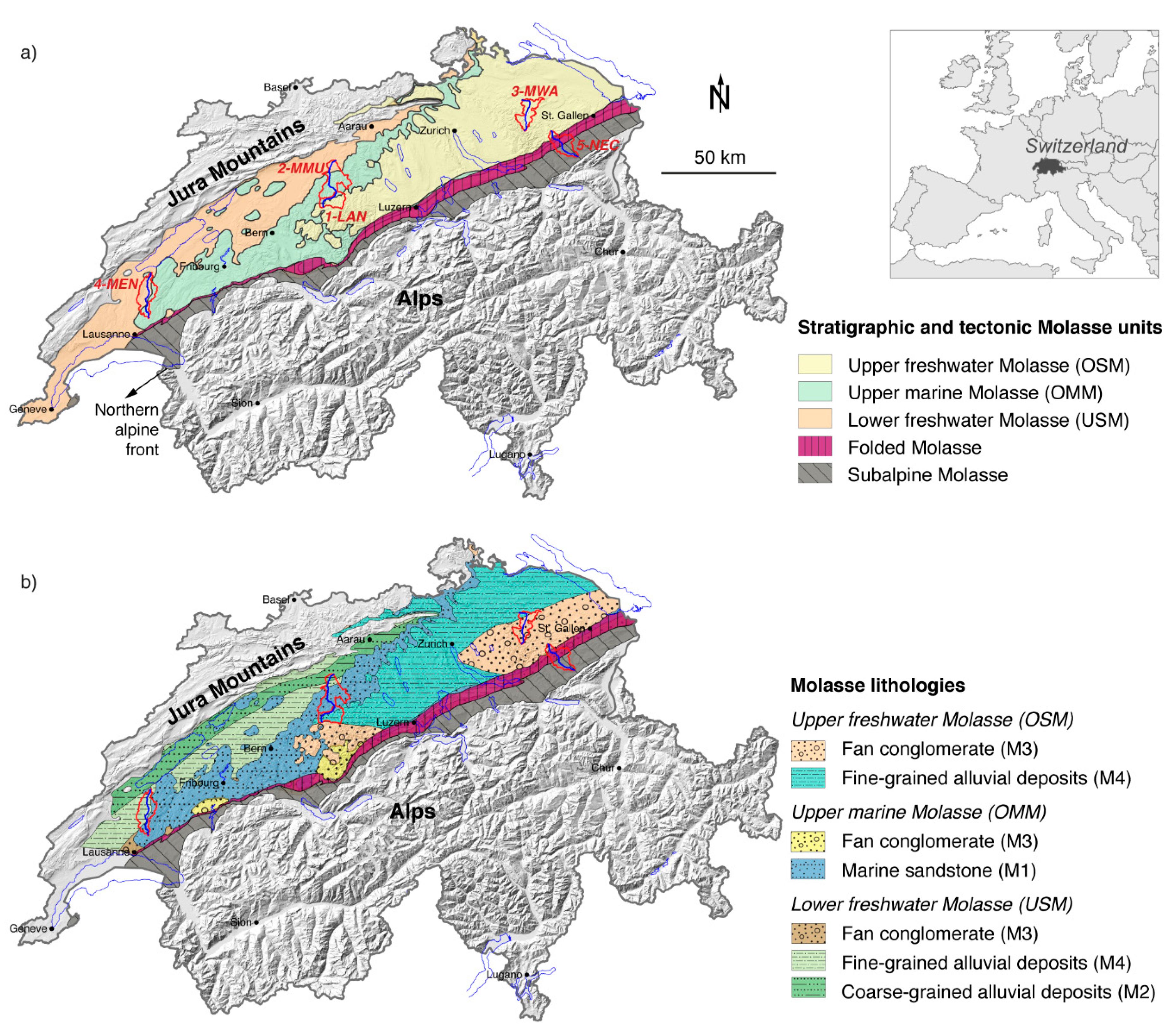
The basin-wide characterization of the Molasse bedrock consists of three data sets. (i) A 2D overview of the traditional stratigraphic Molasse units based on an existing overview map [36]. (ii) Thickness maps of these Molasse units. The thickness map of the upper freshwater Molasse (OSM) is based on the isohypses of its base provided in Gander [37]. The thickness maps of the upper marine Molasse (OMM) and the lower freshwater Molasse (USM) were established using logs of 33 deep boreholes (depths of 660–5900 m) drilled between 1940 and 1998 for petroleum exploration [36,38,39,40,41,42,43] and in the framework of the search for a depository for nuclear waste (e.g., [44,45,46]) (Table S1). Raster images were created by interpolation of depth points in the open-source geographic information system QGIS. The thickness maps allow judging if only the uppermost Molasse unit needs to be considered for assessing the low-flow behavior of a specific catchment, or if also the units below are of importance because unit changes happen at depths considered still relevant for groundwater exchange with the surface (within x00 m). The latter situation occurs for instance when a catchment is located at the edge of a Molasse unit where its thickness fades out. (iii) The lithological model categorizing the Molasse in five principal lithologies. For the determination and the 2D mapping of the five principal Molasse lithologies we used paleo-sedimentological maps published in [47] and further literature discussing the large-scale sedimentological principles of the Molasse [37,48,49]. The 2D maps were created in QGIS by digitizing the data. For attributing a hydrogeological quality to the five defined Molasse lithologies (aquifer/aquitard, K, Peff) (Table 1), we used existing reports about the hydrogeology of the Molasse [27,37,48,50].
For the quantitative geological investigations at the catchment-scale, five catchments were selected based on the following criteria:
The catchment is fully located within the area of Molasse bedrock avoiding the presence of karstified rocks and strongly tectonically overprinted units of the core of the Alps.
There is no glacier influence.
The gauging station is installed at a ‘high-quality position’. ‘High-quality position’ means that the riverine discharge at the station is representative of the complete or near-complete (if considering also the bedrock) catchment outflow. Measuring stations should therefore be positioned on bedrock sills or on impermeable Quaternary deposits. This prevents substantial loss of water in the hydrological budget due to groundwater flowing out of the catchment via alluvial aquifers located below the gauging station.
The catchments cover a large range of the ‘Q95/Q50 index’. The Federal Office for the Environment (FOEN) maintains an extended network of hydrological measuring stations. Most important for this study is the Q95/Q50 ratio calculated using hydrological data from many years of measurements. This ratio of Q95 representing the daily mean discharge exceeded during 95% of the time and of the daily median discharge Q50 serves as an indication for the sensitivity of a catchment to low flows. Ranging between 0 and 1, high values indicate a more constant flow regime throughout the year and thus a higher capability for buffering meteorological changes. Low values, however, indicate that discharge notably decreases during periods with little precipitation and thus delineate catchments with a high sensitivity to low flows. Hence, we use the Q95/Q50 ratio as an indicator (‘Q95/Q50 index’) for the sensitivity of a catchment to low flows. The five catchments we selected for detailed geological analysis represent the full range of Q95/Q50 values that were measured in Molasse catchments equipped with FOEN gauging stations (Q95/Q50 = 0.29 to 0.64) (Table 3).
The selected catchments are 1-Langete (1-LAN), 2-Murg-Murgenthal (2-MMU), 3-Murg-Wängi (3-MWA), 4-Mentue (4-MEN), and 5-Necker (5-NEC) (Table 3). They are well spread across the Molasse basin, ensuring a high variability of geological properties for the analysis. The 1-LAN catchment represents the upper part of the 2-MMU catchment; the 2-MMU catchment includes thus the 1-LAN catchment.
The geological models of the five catchments are based on existing geological data, for management and publication of which the Federal Office of Topography (Swisstopo) is responsible. We used the Geological Atlas of Switzerland 1:25,000 for general, i.e., not sheet-specific, reference [54]; the Tectonic Map 1:500,000 [53]; the map of Groundwater Reserves 1:500,000 [55] for delineating the saturated zone within the Quaternary valley fillings; and the GeoMol raster of the bedrock surface [56] for estimating the volume of Quaternary deposits by subtraction from the Digital Elevation Model (DEM). Both the GeoMol raster as well as the used DEM have a grid resolution of 25 m defining the overall resolution of the calculations. As the base level of a catchment, we used either the altitude of the catchment outlet (i.e., the position of the gauging station) or the level of the maximal glacial overdeepening, if located lower than the gauging station.
In QGIS, we created the planes for the base levels as well as for the boundary layers between Molasse lithologies. Together with the surface topography, this allowed volume calculations for the lithologies and for the saturated zones within the Quaternary. Using these volumes together with their hydrogeological properties presented in Table 1 and Table 2 (based on existing literature, references provided in the tables), we calculated average K and Peff values as well as the pore depth of the saturated zone of the Quaternary for each catchment. Finally, in order to evaluate the geological properties that favor groundwater contribution to stream discharge during low flows, we compared these results with the Q95/Q50 values of the catchments given by gauging data. All numerical results are summarized in the lower part of Table 3. The comparison with the Q95/Q50 values is part of the discussion section.
3. The Swiss Molasse Basin
Besides the geographical and climatic setting, we provide here a summary of the sedimentology, of the tectonics and, importantly, of the hydrogeology of the Molasse. This complements the overview maps (Figure 1 and Figure 3) as well as the geological discussion and the calculations for the five catchments that are presented later (Figure 4 and Figure 5; Table 3). Moreover, little new research has been published on the hydrogeology of the Molasse since the 1990s; therefore, we consider it worthwhile to provide an overview here.
3.1. Geographical and Climate Setting
The Molasse basin is the foreland basin of the Alps, where the Alpine debris accumulated during the Oligocene and Miocene (34 to 10 Ma) as a result of increased erosion during the Alpine orogenesis [57,58]. The Molasse basin has a total length of about 1000 km (NE–SW orientation) and a width varying between 10 and 130 km covering areas of Austria, Germany, Switzerland, and France. Here, we focus on the part of the Molasse basin located in Switzerland.
The climate is dominated by mild and humid westerly flows from the Atlantic, alternating with stable high-pressure conditions, or by continental air from the north, reaching the Molasse basin when high-pressure conditions act over Central and Northern Europe and low pressure over the Mediterranean. The average temperature is 9.4 °C in the lowlands (e.g., meteorological station Bern-Zollikofen, 553 m asl, 2000–2016) and 7.1 °C at higher altitudes and closer to the Alps (e.g., station Hoernli at 1144 m asl, 2000–2016) (MeteoSwiss data). Total precipitation varies between ~1000 mm/year in the lowlands and ~1500 mm/year in higher areas.
3.2. Sedimentology and Tectonics of the Molasse
The Molasse is primarily composed of clastic sedimentary rocks characterized by different grain sizes, from silt and clay stones to sandstones and conglomerates. Sediments were alternatingly deposited during two marine and two terrestrial stages during the Oligocene and Miocene (34 to 10 Ma) [59,60].
The stratigraphy of the Molasse has traditionally been subdivided into four major units: lower marine Molasse (UMM = Untere Meeresmolasse (German);), lower freshwater Molasse (USM = Untere Süsswassermolasse), upper marine Molasse (OMM = Obere Meeresmolasse), and upper freshwater Molasse (OSM = Obere Süsswassermolasse). Throughout this manuscript, the expression ‘Molasse unit’ refers to this traditional stratigraphy. The UMM will not be examined individually in this study, as it occurs mostly within the Subalpine Molasse that we treat as a distinct Molasse lithology for our hydrogeological assessment (Table 1).
Maps illustrating the paleo-sedimentological conditions during the deposition of the four Molasse units are illustrated in Trümpy [47]. The lower marine unit (UMM) is composed of turbidite deposits (alternation of sandstone and marl) and marls [48]. In contrast, the upper marine Molasse (OMM) is characterized by an extensive shallow ocean with tide- and wave-dominated beaches as depositional environment and by sandstone as the predominant lithology [61] (Figure 1). However, proximal to the Alpine front where rivers entered the shallow marine basin, the OMM is characterized by alluvial fan conglomerates. The stages of the freshwater Molasse (USM and OSM; Figure 1) are characterized by proximal alluvial fan conglomerates and distal fine-grained but heterogeneous alluvial deposits. Overall, a grain-size decrease with increasing distance from the Alps is observed [48]. An exception is a NE–SW orientated drainage channel in the northern part of the Molasse basin that is characterized by anomalously coarse-grained deposits when considering the distance to the Alpine front.
The terrestrial deposits occurring within the OMM, together with the varying lithology of the freshwater Molasse, illustrate that the discussion of the hydrogeological quality of the Molasse cannot be solely based on the four traditional Molasse units, since spatial variation of lithologies is not sufficiently represented by this concept. Developing a lithological overview of the Molasse as it is presented in Figure 1b is therefore a precondition for the hydrogeological assessment.
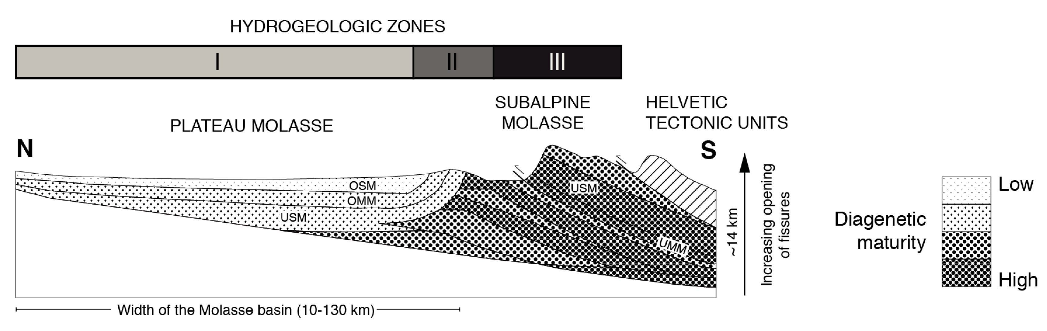
Tectonically, three Molasse sections are distinguished from S to N: the Subalpine, the Folded, and the Plateau Molasse (Figure 1 and Figure 2) [48,58]. The Subalpine Molasse was tectonically overthrusted onto the Molasse basin and has thus experienced substantial stress and compaction and partly also fracturing (dip direction/angle ~160°/45°) ([54] sheet 57). The Subalpine Molasse consists principally of UMM and USM. Adjacent to the Subalpine Molasse, a section of folded and tilted Molasse and finally the Plateau Molasse, characterized by little tectonic deformation and a horizontal to subhorizontal layering, follow. However, in the western part of the basin (W and N of Lausanne) faults are abundant in the Plateau Molasse [53,54], resulting in a limited accuracy of our thickness maps that were created by point interpolation (Figure 3).
Variation in estimations for post-depositional erosion (<10 Ma) is significant (±50%) [60]. Monnier [62] estimated 1000–1200 m of erosion in the western and central sectors of the Swiss Molasse basin and 500 m in the east. Another estimation indicates 2–2.6 km of erosion for the Plateau Molasse and 4.3 km of erosion for the Subalpine Molasse [63]. The importance for the present study is the deduction that all units presently located at the surface were once covered by at least another 500 m of rocks and thus experienced substantial compaction.
3.3. Hydrogeology of the Molasse
Literature describing the hydrogeological properties and quality of the Molasse is limited. The most complete and detailed discussion about the sedimentological and hydrogeological architecture of the four Molasse units is provided in Keller [48]. In addition, there are reports by NAGRA (National Cooperative for the Disposal of Radioactive Waste) about the two freshwater Molasse units [37,49] since aquitard levels therein were formerly considered as potential host rock for the repository of nuclear waste. These reports, however, again rely largely on the before-mentioned Keller [48] study. Overall, the two freshwater Molasse units (USM, OSM) are characterized as ‘little permeable with locally occurring permeable layers (principally sandstone-filled channels)’, while the marine Molasse (OMM) is characterized as a ‘regional aquifer’ [64].
Considering in more detail the lithological composition of the freshwater Molasse, the proximal fan conglomerates that are often interlayered by marls are characterized as aquitard (Table 1, with references for the presented values; M3, K = 10−6 to 10−8 m/s). With increasing distance to the Alps, a transition zone with mixed grain sizes and finally the fine-grained deposits of the alluvial plain follow. The architectural elements of the alluvial plain are diverse (Table 1; M4, K = 10−7 to 10−11 m/s), resulting in a locally restricted occurrence of the different deposits. This heterogeneity importantly contributes to the aquitard character of the alluvial plain deposits. For instance, even though permeable sandy channel fillings exist, their occurrence is isolated within marly or clayey deposits, and therefore, no coherent aquifer can form. The axial channel system at the northern edge of the Molasse basin is characterized by interconnected sandstone belts, which may form regional porous aquifers (Table 1; M2, K = 10−4 to 10−8 m/s). Hence, porosity and permeability are higher than in the case of the fine-grained alluvial deposits.
The upper marine Molasse (OMM) is, as the freshwater Molasse, proximally composed of fan conglomerates acting as aquitards (Table 1; M3). Yet, the sandstone lithology of the OMM present in large parts of the Molasse basin is responsible for the overall aquifer character of the OMM (Table 1; M1, K = 10−4 to 10−5 m/s). The extent of the aquifers should nevertheless be considered as regional (and not basin-wide) since intercalated fine-grained layers or bodies with a lower permeability may act as sealing layers.
The Subalpine Molasse is due to its high diagenetic maturity and substantial compaction characterized by a low primary porosity and a low permeability. Tectonic overprinting, however, could have caused significant fracturing. Therefore, the Subalpine Molasse can locally act as fractured aquifer (Table 1; M5, K = 10−5 to 10−7 m/s). It is worth noting that it is generally unknown if a hydrogeological connection exists between the Subalpine Molasse and the adjacent Folded and Plateau Molasse, or if the Subalpine Molasse represents a hydrogeologically isolated body.
At the Molasse surface, a weathering horizon of several meters with ‘similar properties as unconsolidated sediments’ is often observed [48]. This horizon is characterized by an increased porosity (secondary porosity) as a result of weathering processes (e.g., dissolution of cement), as well as by a hydraulic conductivity a factor of 10 higher than the one characterizing the underlying non-weathered Molasse rocks. For this study, we assume that this weathering horizon is uniformly distributed, and thus, we do not explicitly specify it in our calculations.
3.4. Quaternary Deposits
The large Pleistocene glaciations importantly formed the landscape of the Swiss Molasse basin by bedrock erosion including overdeepening along the principal glacial valleys, as well as by the deposition of glacial, fluvio-glacial, and glacio-lacustrine sediments [65,66]. Unconsolidated Quaternary sediments are of high importance for water resources in the Alpine foreland, providing about 50% of the drinking water. Coarse-grained fluvio-glacial or post-glacial (i.e., Holocene) fluvial deposits, often found in overdeepened troughs and along river courses, are most productive and thus of paramount importance (Table 2) [26,27]. These porous aquifers are the primary water resource in large parts of the Molasse basin. In addition, a variety of unconsolidated deposits with varying hydrogeological quality may occur: debris of slides and of slope slagging, fine-grained alluvial overwash deposits, fine-grained lacustrine deposits, lateral and frontal moraines, and deposits with aquitard character, such as basal moraines (lodgment till) and peat.
4. Results
4.1. Lithological Model and Hydrogeological Classification of the Molasse
We categorized the Molasse into five principal lithologies, based on the S–N grain-size evolution in the Molasse basin as described in Section 3.2 and their hydrogeological quality described in Section 3.3: marine sandstones (M1), coarse-grained alluvial deposits (M2), fan conglomerates (M3), fine-grained alluvial deposits (M4), and the Subalpine Molasse (M5) (Figure 1b; Table 1). Figure 1b shows the spatial 2D distribution of the five lithologies based on the paleo-sedimentological maps published in Trümpy [47]. Color-coding indicates to which Molasse unit the lithology belongs. In addition, this map shows the zones of the Subalpine and the Folded Molasse [53].
Average values for K and Peff presented in Table 1 are based on existing literature [27,37,48,50]. While the fan conglomerates (M3, K = 10−6 to 10−8 m/s, Peff = 10%,) and the fine-grained alluvial deposits are classified as aquitards (M4, K = 10−7 to 10−11 m/s, Peff = 0%–5%), the sandy coarse-grained alluvial deposits (M2, K = 10−4 to 10−8 m/s, Peff = 5%) and, in particular, the marine sandstone represent porous aquifers allowing intergranular groundwater flow (M1, K = 10−4 to 10−5 m/s, Peff = 5–10%). The Subalpine Molasse is to be considered either as aquitard if compact or as a fractured aquifer if tectonic overprinting induced significant fracturing (M5, K = 10−5 to 10−7 m/s, Peff = 5%).
4.2. Hydrogeological Classification of the Quaternary Deposits
For the Quaternary deposits, we distinguish four hydrogeological groups. The coarse-grained valley fillings (Q1) (gravel, sand) represent the high-productive porous aquifers (Q1, K = 10−2 to 10−3 m/s, Peff = 20–25%). Other non-compacted and largely inorganic deposits with varying hydrogeological quality from porous aquifer to aquitard were summarized in group Q2 (K = 10−4 to 10−6 m/s, Peff = 10–25%). Only small volumes of this group Q2 have a permeability that is comparable in quality to Q1. We therefore consider the Q2 group in the present study, i.e., a potentially important geological factor for sustaining stream flow during dry spells, as non-relevant. We defined specific groups for lodgment tills (Q3, K ≤ 10−6 m/s, Peff = 5–10%), since they are glacially precharged and thus compacted, as well as for peat (Q4, K = 10−5 to 10−8 m/s) as a primarily organic sediment. Both of the latter are considered as aquitards.
4.3. Thickness Maps of the Molasse units (OSM, OMM, USM)
The thickness maps allow estimating the continuation with depth of the Molasse lithologies (Figure 3). The maps are valid for the Plateau Molasse, where strata have a horizontal or subhorizontal orientation. The maps lack, however, detailed data input (faults and folds) for accurately representing the thickness of the folded and the Subalpine Molasse. For this study, this is irrelevant, given the large thickness of these two units clearly reaching beyond the hydrogeological base levels that we used or that could generally be of interest in this geology-based low-flow assessment.
The OSM is only present in the eastern and central parts of the Molasse basin, with a generally decreasing thickness from east to west. The data source for the USM and OMM maps are point measurements (33 deep boreholes); they thus largely ignore large-scale low-amplitude folds. Our approach is thus simplified in regard to local and regional tectonic features. Since the scope of this study is to develop a method that allows efficiently estimating if a certain catchment or region is potentially sensitive to low flows without exhaustive geological explorations (see Section 2), a certain geological simplification is part of the approach. Nevertheless, a zone with substantial faulting is located in the western part of the Molasse basin in the region north and west of Lausanne. In order to indicate the increased uncertainty, we present this zone as hatched on the maps (Figure 3).
4.4. Geological Models of the Five Selected Catchments
The five catchments for which a detailed geological assessment was realized are well distributed over the Molasse basin and are thus representative of the full range of the discussed Molasse units and lithologies. Besides, they also cover the full range of Q95/Q50 values (0.29 to 0.64) observed in the gauged catchments of the Molasse basin. For numerical results and catchment properties see Table 3.
In the following, we shortly present the geology of the five catchments:
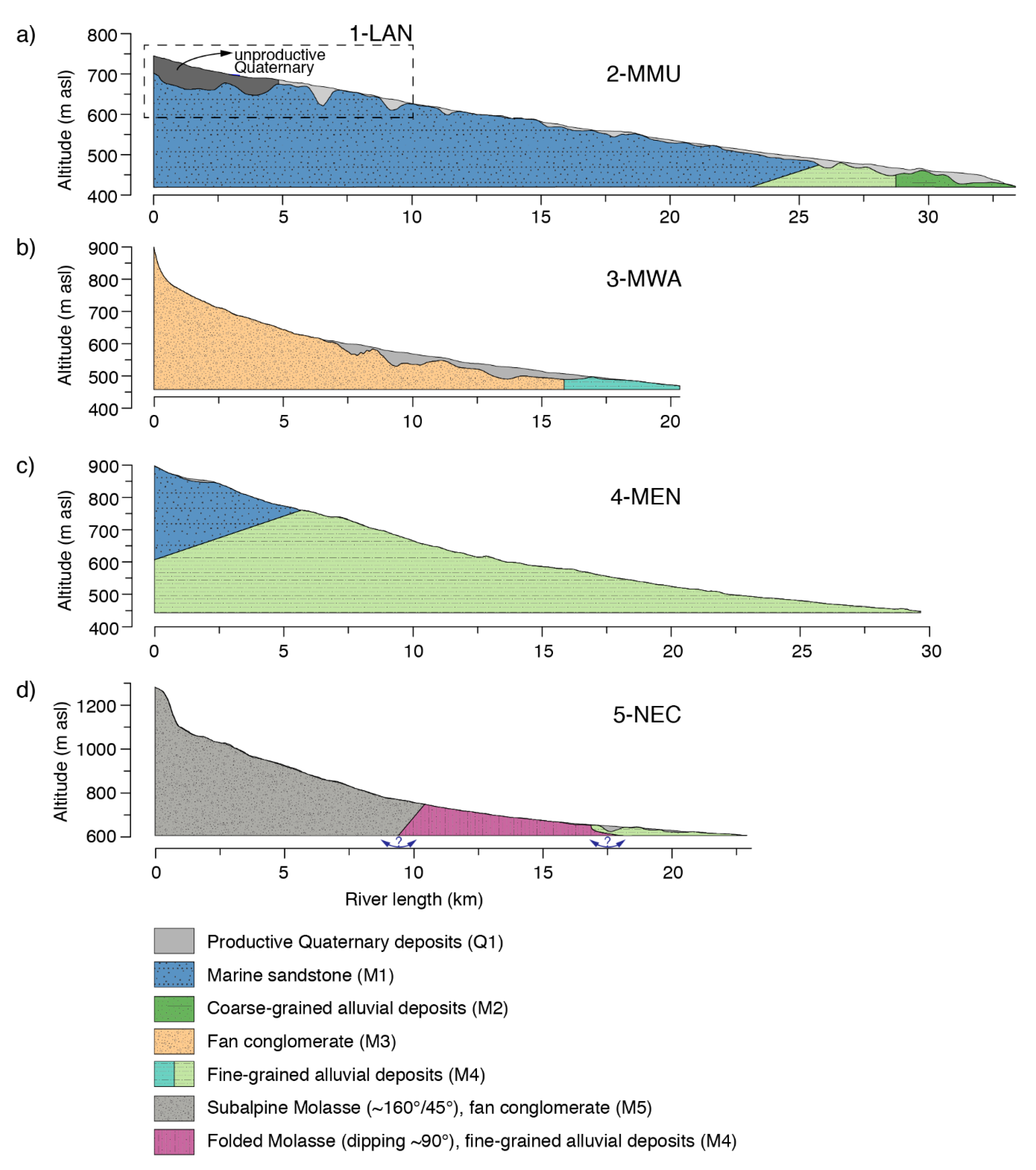
The 1-LAN catchment (Figure 4a) is located in the area of the northern limit of the OSM. OSM and, further north, the below-lying OMM represent the uppermost Molasse unit. We defined the boundary horizon between OSM and OMM based on profiles included in the explanatory notes of ([54] sheets 79 and 1148). The base level of our model is defined by the glacial overdeepening to 592 m asl in the lower reach, which is slightly deeper than the location of the gauging station (597 m asl). Considering the total geological volume (100%), sandstone dominates (56.9%) over the above-lying fine-grained alluvial deposits (40.0%). The saturated zone in the Quaternary deposits accounts for 1.7% of the total geological volume. The valley filling representing this saturated zone mainly consists of coarse-grained deposits (gravel and sand) and only little fine-grained material (crossing profiles in [67]). Quarternary deposits filling the overdeepening in the upper reach of the river are non-productive.
The 2-MMU catchment (Figure 4a) contains three Molasse units and four Molasse lithologies: OSM (fine-grained, M4), OMM (sandstone, M1), and USM (fine-grained M4 and coarse-grained M2). The upper part of the catchment corresponds to the 1-LAN catchment. The interface between OMM and USM is based on the top of the USM defined in the USM thickness map (Figure 3c). The interface between the fine-grained and the coarse-grained deposits of the USM in the lowest reach is assumed as being vertical. The sandstone lithology (M1) clearly dominates in this catchment (84.5%). Important saturated zones of Quaternary deposits (1.0%) are present in the upper reach (cf. 1-LAN) and in a ~15 km-long stretch above the gauging station. These productive zones mainly consist of coarse-grained deposits with little fine-grained material (crossing profiles in [68]). The base-level corresponds to the elevation at the gauging station (419 m asl).
The 3-MWA catchment (Figure 4b) is located nearly exclusively within the fan conglomerates (M3) of the OSM (89.9%) that are interlayered by marls and sandstones [34,69]. Only a small area near the outflow is composed of fine-grained deposits (M4) of the OSM (4.4%). Glacial overdeepening is important, and the saturated zone within the Quaternary valley fillings accounts for 1.2% of the total geological volume. The base level is with 458 m asl defined slightly deeper than the elevation at the gauging station (466 m asl).
The 4-MEN catchment (Figure 4c) is located in the western part of the Swiss Molasse basin where the OMM thins out, and the USM is primarily present as the uppermost Molasse unit. The definition of the OMM-USM boundary horizon is based on the contact outcropping at the surface as well as on geological profiles providing additional point information on the altitude of the boundary layer ([54] sheets 27 and 94). The OMM sandstone (M1) (13.5%) is present in the eastern part of the catchment. Sandstone strata in some areas slightly dip towards the east. The USM consists of fine-grained alluvial deposits (M4) and dominates the geological volume of the catchment (84.5%). Glacial overdeepening is absent. As a consequence, there is no hydrogeologically productive Quaternary volume. Quaternary deposits primarily consist of a thin layer of weathered moraine covering large parts of the catchment ([54] sheets 27 and 94). As this weathered moraine may be considered as identical to a weathered Molasse surface (see Section 3.3), we consider it as being part of the Molasse volume. The base-level corresponds to the altitude of the gauging station (443 m asl).
The 5-NEC catchment (Figure 4d) is located in the transition zone of the Subalpine, folded and Plateau Molasse in eastern Switzerland. The Subalpine Molasse (M5) represents the largest volume in this catchment (64.2%) and is dipping towards SSE (~160°/45°) ([54] sheets 4 and 141). The folded Molasse consists of fine-grained alluvial deposits (M4) (29.8%) and is strongly tilted (~90°). The small fraction of the Plateau Molasse present in this catchment also consists of fine-grained alluvial deposits (M4) (4.7%). Glacial overdeepending and thus productive valley aquifers are absent. Consequently, the base level corresponds to the elevation at the gauging station (606 m asl).
4.5. Hydrogeology of the Five Selected Catchments
Combining the calculated lithology volumes of the bedrock and the saturated zones within the Quaternary (Section 4.4) average hydrogeological properties of the bedrock (K, Peff), as well as the pore depth of the saturated zones within the Quaternary using a porosity of 22.5% (Q1; Table 2), were calculated (Table 3).
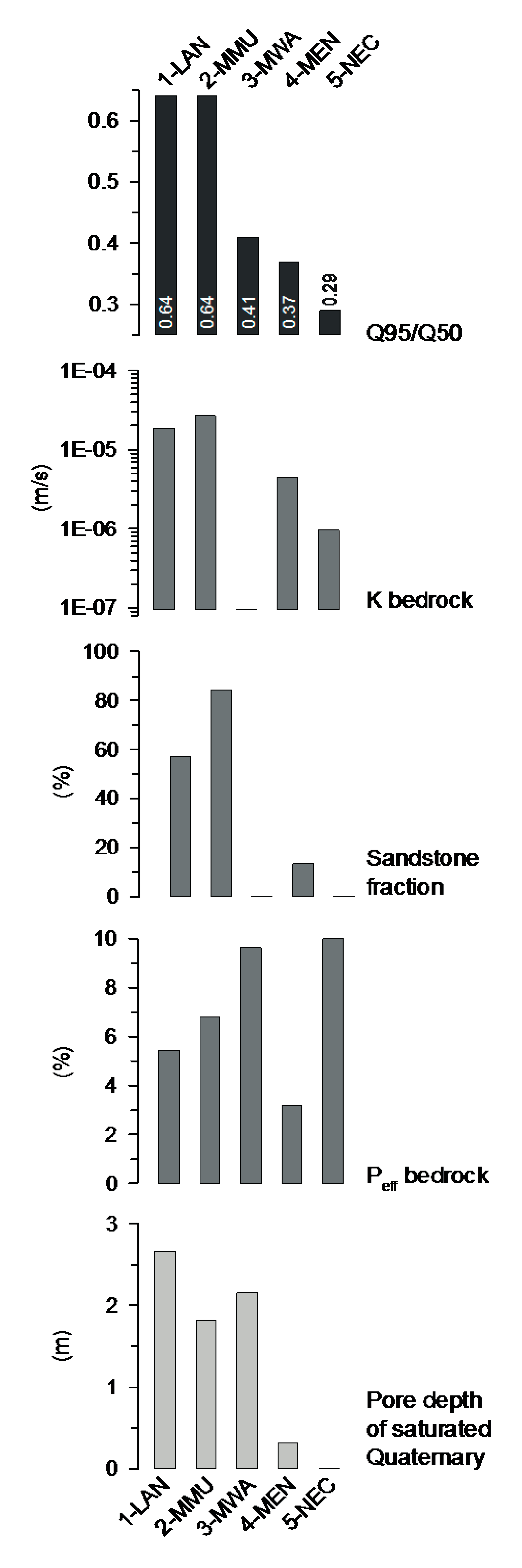
The 1-LAN and the 2-MMU catchments clearly show the highest average K values of the bedrock (1.9 × 10⁻⁵ m/s and 2.7 × 10⁻⁵ m/s, respectively) (Table 3; Figure 5). 3-MWA (9.5 × 10⁻⁸ m/s), 4-MEN (4.4 × 10⁻⁶ m/s), and 5-NEC (9.5 × 10⁻⁷ m/s) show lower K values by a factor of 10 to 103. Considering Peff of the bedrock, the situation is different. Here, it is the 3-MWA (9.6%) that shows the highest value (Table 3; Figure 5). This is primarily due to the comparably high—and possibly overestimated—effective porosity that is attributed to the fan conglomerates (10%) (Table 1). Peff lies in a similar range for 1-LAN (5.4%), 2-MMU (6.8%), and 5-NEC (6.7%) but is lower for 4-MEN (3.2%). The pore depth of the saturated zones within the Quaternary is similar for 1-LAN, 2-MMU, and 3-MWA but quasi zero for 4-MEN and 5-NEC. The reason is the absence of overdeepening and thus the missing coarse-grained valley fillings in the cases of 4-MEN and 5-NEC.
5. Discussion
5.1. Geological Factors Controlling Sensitivity to Low Flows
In Section 3, we provided a summary of the geology, the tectonic setting, and the hydrogeology of the Molasse basin. Based on this summary and the overview maps (Figure 1 and Figure 3), we were able to reorganize the Molasse units into Molasse lithologies. This allowed us to calculate lithology-specific volumes and average K and Peff values for the five selected catchments. Based on these results, we discuss the geological and tectonic properties that account for the variability of Q95/Q50 values among the five catchments in the following.
The comparison of the hydrogeological properties of the five catchments with their Q95/Q50 index draws an explicit pattern of the lithologies and their hydrogeological properties favorable for groundwater contribution during low flows (Figure 5). Furthermore, the vertical arrangement of the lithologies as well as the tectonic setting also seems to be important.
The catchments least sensitive to low flows within our study group, i.e., the catchments with the highest Q95/Q50 index, contain a substantial amount of sandstone acting as a porous aquifer (Table 3). This is the case for the 1-LAN and the 2-MMU catchments, where both catchments are characterized by a Q95/Q50 index of 0.64 and where the marine sandstone dominates the geological volume (56.9% and 84.5%, respectively). Interestingly, the 2-MMU catchment is not less sensitive to low flows than the 1-LAN catchment even though it has a higher proportion of marine sandstone. In the following, we discuss three reasons for this favorable behavior of the 1-LAN catchment. (i) Relatively seen, the volume of productive Quaternary deposits in the 1-LAN catchment (1.7%) exceeds the one in the 2-MMU catchment (1.0%), even though the Quaternary in the upper part of the 1-LAN catchment is not productive (Figure 4a). (ii) The fine-grained alluvial deposits (M4), thus the non-sandstone fraction of the bedrock volume, are located in the upper reach of the 1-LAN catchment (not visible in Figure 4a, as sandstone does not occur along the drawn river profile). This specific vertical arrangement of low-permeable rocks in the upper and high-permeable rocks in the middle and lower reaches of the river is probably favorable. Surface runoff on the fine-grained low-permeable lithology (M4) subsequently infiltrates into the sandstone aquifer. Thus, the groundwater flow reaches the outlet and is not impeded by low-permeable units or geological boundary layers. (iii) The fine-grained alluvial deposits (M4) present in the lower reach of the 2-MMU catchment may act as a hydrogeological boundary layer limiting the continuation of the groundwater flow from the marine sandstone. If groundwater was led to larger depths following this boundary, it would signify a water loss for the catchment. However, it is also possible that groundwater is forced to the surface along the boundary layer, which would have the opposite effect and thus be favorable for the surface runoff and the Q95/Q50 index.
In addition to the marine sandstone, the presence of productive Quaternary deposits is the second important factor allowing a robust discharge behavior during low flows. We draw this conclusion primarily from the low-flow behavior and the geological characteristics of the 3-MWA catchment. This catchment is characterized by a low mean hydraulic conductivity of the bedrock (9.5 × 10⁻⁸ m/s) but an intermediate Q95/Q50 index (0.41) (Figure 5). We suggest that the productive Quaternary volume is, to a certain degree, able to buffer low-flow conditions. Moreover, for the favorable low-flow behavior of the 1-LAN and 2-MMU catchments (Q95/Q50 = 0.64), not only the presence of sandstone may be decisive but the combination of a slowly and steadily draining bedrock with high-permeable Quaternary deposits allowing a constant recharge of the Quaternary aquifer.
When assessing the volume and porosity of the Quaternary valley fillings, a difficulty that may occur is the often insufficiently known 3D architecture of these deposits. Exploited high-quality aquifers are mostly present in the upper 10–20 m of the sediment column. The deeper but often unexplored interval of the valley fillings, however, may have a different lithology. Glacio-lacustrine and thus impermeable fine-grained deposits of thicknesses of tens of meters are common in Alpine overdeepened valleys [66,70,71]. In such a case, the pore depth of the Quaternary deposits that we calculated (Table 3, Figure 5) would not be accurate. In the case of the 1-LAN, 2-MMU, and 3-MWA catchments, however, this uncertainty could be avoided, since detailed hydrogeological studies characterizing the valley fillings are available [34,67,68,69]. In the real world, however, this issue of missing information on the 3D lithological architecture of the Quaternary valley fillings may represent an important knowledge gap during a low-flow assessment.
The stratigraphic and tectonic setting may also have an influence on the low-flow behavior of a catchment. For illustration, we used the 4-MEN and the 5-NEC catchments showing an unfavorable low-flow behavior (Q95/Q50 = 0.37 and 0.29). Both are characterized by low-permeability bedrock combined with the absence or near-absence of productive Quaternary deposits. Notable is, however, that the average K of the 4-MEN catchment is relatively high with 4.4 × 10⁻⁶ (Table 3). This is primarily the strong effect of the 13.5% of sandstone that is present in the catchment. Yet, the sandstone fraction is positioned above the low-permeable alluvial deposits (M4) in 4-MEN, and it is not present in the river valley along a large fraction of the river profile (Figure 4c). In addition, the sandstone dips towards the east, potentially allowing drainage into a neighboring catchment with the below-lying fine-grained Molasse lithology acting as sealing layer. We therefore hypothesize that (i) the vertical arrangement of porous bedrock aquifer above aquitard (i.e., inverse to the situation in 1-LAN), (ii) the limited presence of a porous bedrock aquifer in the river valley, and (iii) the unfavorable dipping orientation of the porous bedrock aquifer are unfavorable for sustaining stream flow in the 4-MEN catchment. In the case of the 5-NEC catchment, the low-permeability bedrock, combined with the missing productive Quaternary, is very likely decisive for the low Q95/Q50 index. However, additional factors could be responsible for the high sensitivity to low flows. (i) The catchment contains three tectonic units: the Subalpine, the Folded, and the Plateau Molasse. Possibly, the continuation of groundwater flow across these units is limited to absent, and as a consequence, they represent hydrogeologically isolated bodies. Yet, no further data to prove or reject this hypothesis exist at this time. (ii) The river gradient and in particular the catchment slope are steeper than in other catchments (Table 3). In combination with the low permeability of the bedrock, this might lead to a fast, superficial drainage of precipitation or snowmelt water with only little infiltration into the bedrock.
The valley width (Table 3) might provide a weak indication about the sensitivity to low flows, as it is to some degree defined by glacial erosion and thus related to the volume of Quaternary deposits (R2 = 0.66). A comparison of our findings with the river gradients and the average catchment slopes did not lead to a clear picture. As mentioned above, it is possible though that the comparably steep catchment of 5-NEC (13.9°) favors fast surface water runoff on the impermeable bedrock and thus diminishes infiltration. This would ask for a continuing study including topography and infiltration conditions.
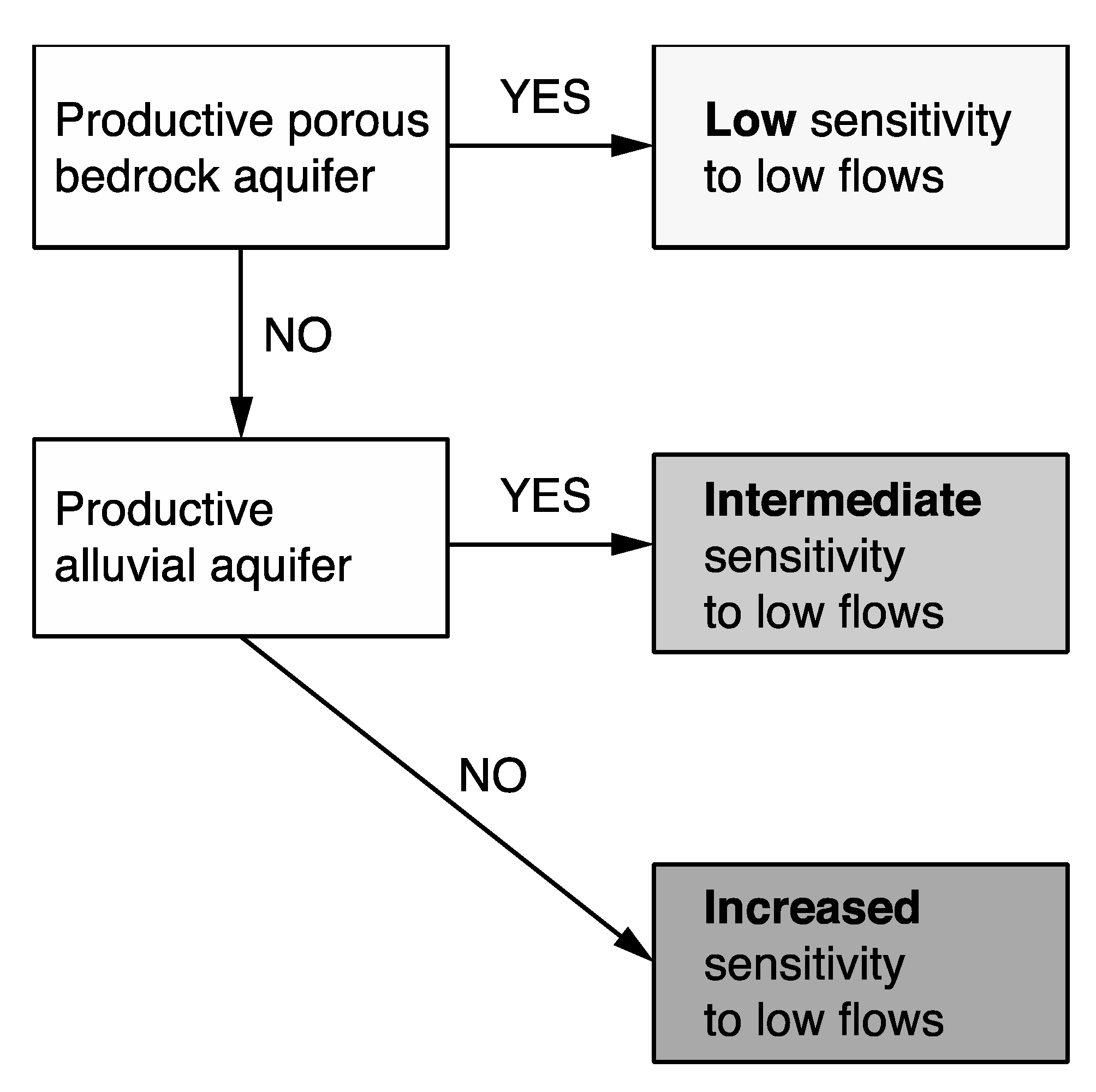
In summary, we rank the catchments as follows in regard to their sensitivity to low flows (Figure 6).
- Low sensitivity: catchments with a permeable bedrock (M1, M2) and productive Quaternary deposits (Q1) as porous aquifers.
- Intermediate sensitivity: catchments with a low-permeable bedrock (M3, M4, M5) but productive Quaternary deposits (Q1).
- High sensitivity: catchments with a low-permeability bedrock (M3, M4, M5) and no productive Quaternary deposits (Q1).
In addition, the tectonic setting (dip direction of strata, fault, and thrust zones) likely influences the groundwater flow across catchments or leads to groundwater isolation within a specific geological body (tectonic compartmentalization).
These results using real catchments are consistent with recent studies realized within the same project using linear regression and HydroGeoSphere [72] modeling for depicting the most important characteristics making a catchment less sensitive to low flows [18,19]. The authors showed that the hydraulic conductivity of the bedrock and a productive alluvial aquifer in case of a low conductivity of the bedrock are the most important characteristics of catchments for increasing their capability to sustain stream flow during dry spells. In addition, catchments with a stable stream flow are characterized by important fluctuations of the stored groundwater volume. Ergo, both the present study using real data and the modeling study arrived independently at the same conclusion. This highlights the robustness of the results and allows more realistic hydrogeological modeling using authentic permeability and porosity values.
5.2. Recommendations for Water Management
In practice, when realizing a first-order geology-based assessment of the sensitivity of a catchment to low flows, the following two essential geological properties should be examined (see also Figure 6):
- (1)
- Presence or absence of a slow-draining porous bedrock aquifer enabling continuous recharging of the river and/or the Quaternary aquifers;
- (2)
- Presence or absence of productive Quaternary aquifers.
Importantly, these criteria are straightforward in their application. Finding such an easy-to-use decision tool was a primary objective of this study. Furthermore, these criteria are not only valid for the Swiss Molasse basin but also provide a valuable base for low-flow assessments in other regions worldwide, in particular in areas where porous bedrocks (e.g., clastic sedimentary rocks and volcanoclastics) occur.
5.3. Limitations
During the collection of data for this study, we encountered some limitations regarding the assessment of the hydrogeological quality of the Molasse bedrock and of the Quaternary deposits.
The amount of published P and K values for the Molasse is limited and the range of values reported for the same lithology may vary by a factor of 10 to 100. Swiss-wide, 19 K values are available for the OMM and 13 for the USM from borehole investigations [73]. Variability of the values is less important for the marine sandstone but higher for the rather heterogeneous deposits, such as conglomerates intercalated by marls. If a detailed hydrogeological assessment of a catchment is planned, P and K of the bedrock should thus ideally be newly determined.
The knowledge about the architecture of the Quaternary valley fillings is variable. In some areas, a high amount of detail is known through geophysical investigations and boreholes, e.g., for the 1-LAN and 2-MMU catchments [67,68], while at other sites, little information is available beyond the uppermost ten to twenty meters.
The groundwater exchange between the tectonic units Subalpine, Folded, and Plateau Molasse is largely unknown (see also Section 3.3). Should the fault zones define isolated hydrogeological bodies, this would affect the amount of groundwater that flows from the top of a catchment to the outlet. Furthermore, it remains rather open to which depth bedrock groundwater has to be considered. This uncertainty affects the definition of the base level of a catchment. The way of how the hydrogeological base level is defined reflects to what depth groundwater is considered and influences the total geological volume of a catchment. We used a block model, with the base level as a horizontal plane at the level of the gauging station or at the level of the most pronounced overdeepening. Alternatively, models with a base level following the river course at a constant depth may be used. Finally, we did not consider the degree of soil formation, vegetation cover, or the thickness of the weathered layer in this study. They may be dependent on the underlying geology and on the altitude and may influence infiltration.
6. Conclusions
In this study we approached an important knowledge gap regarding the influence of the geology, in particular of the occurring lithologies and the tectonic structures, on stream flow during low-flow conditions in a certain catchment. Since groundwater contribution to stream discharge is essential for sustaining river flow during dry periods, the geology must play an essential role. Former studies, however, have more strongly focused on the hydrological and topographic characteristics. Therefore, we contributed to closing this knowledge gap by scrutinizing the geological control on low flows. Importantly, we did not only consider the surface geology (2D) but incorporated the continuation of lithologies with depth (3D).
We explored which properties of the bedrock and the Quaternary deposits can explain the sensitivity to low flows of catchments located in the Swiss Molasse basin. The main objective was to determine the most critical geological factors that define or at least strongly influence a catchment’s low-flow behavior. Such a straightforward geological assessment enables estimating the low-flow sensitivity even of ungauged basins and is therefore of great benefit for water resource managers worldwide.
In conclusion, (i) the presence of a porous bedrock aquifer is the first determining factor for a low sensitivity to low flows. (ii) If a porous bedrock aquifer is absent, the volume of the productive Quaternary deposits becomes important, representing the second determining factor. In this case, sensitivity to low flows is estimated as intermediate. (iii) If both a porous bedrock as well as productive Quaternary deposits are absent, the catchment is categorized as increased sensitive to low flows. Hence, water managers should focus on the presence of a porous bedrock aquifer and/or productive Quaternary deposits when assessing the sensitivity to low flows of a certain catchment in practice.
Supplementary Materials
The following are available online at https://www.mdpi.com/2073-4441/12/3/821/s1, Table S1: Compilation of depth information from 33 deep boreholes for constructing the OMM and USM thickness maps.
Author Contributions
Conceptualization, all; methodology, S.B.W.; software, S.B.W., F.C. and C.C.; validation, C.C., F.C., D.H. and P.B; formal analysis, S.B.W.; investigation, S.B.W.; resources, S.B.W. and C.C.; data curation, S.B.W. and C.C.; writing—original draft preparation, S.B.W.; writing—review and editing, ALL; project administration, D.H. and P.B.; funding acquisition, D.H. and P.B. All authors have read and agreed to the published version of the manuscript.
Funding
This research was funded by the Federal Office of the Environment (FOEN; Project: ‘Auswirkung der Klimaänderung auf das Grundwasser und Niedrigwasserverhältnisse in der Schweiz’).
Acknowledgments
We thank Werner Balderer for the discussion on the hydrogeology of the Molasse.
Conflicts of Interest
The authors declare no conflict of interest.
References
- Marx, A.; Kumar, R.; Thober, S.; Rakovec, O.; Wanders, N.; Zink, M.; Wood, E.F.; Pan, M.; Sheffield, J.; Samaniego, L. Climate change alters low flows in Europe under global warming of 1.5, 2, and 3 °C. Hydrol. Earth Syst. Sci. 2018, 22, 1017–1032. [Google Scholar] [CrossRef] [Green Version]
- Middelkoop, H.; Daamen, K.; Gellens, D.; Grabs, W.; Kwadijk, J.C.J.; Lang, H.; Parmet, B.W.A.H.; Schädler, B.; Schulla, J.; Wilke, K. Impact of Climate Change on Hydrological Regimes and Water Resources Management in the Rhine Basin. Clim. Chang. 2001, 49, 105–128. [Google Scholar] [CrossRef]
- Smerdon, B.D. A synopsis of climate change effects on groundwater recharge. J. Hydrol. 2017, 555, 125–128. [Google Scholar] [CrossRef]
- Hartmann, D.L.; Klein Tank, A.M.G.; Rusticucci, M.; Alexander, L.V.; Brönnimann, S.; Charabi, Y.; Dentener, F.J.; Dlugokencky, E.J.; Easterling, D.R.; Kaplan, A.; et al. Observations: Atmosphere and Surface. In Climate Change 2013: The Physical Science Basis. Contribution of Working Group I to the Fifth Assessment Report of the Intergovernmental Panel on Climate Change; Stocker, T.F., Qin, D., Plattner, G.-K., Tignor, M., Allen, S.K., Boschung, J., Nauels, A., Xia, Y., Bex, V., Midgley, P.M., Eds.; Cambridge University Press: Cambridge, UK; New York, NY, USA, 2013. [Google Scholar]
- Price, K. Effects of watershed topography, soils, land use, and climate on baseflow hydrology in humid regions: A review. Prog. Phys. Geogr. 2011, 35, 465–492. [Google Scholar] [CrossRef]
- Sayama, T.; McDonnell, J.J.; Dhakal, A.; Sullivan, K. How much water can a watershed store? Hydrol. Process. 2011, 25, 3899–3908. [Google Scholar] [CrossRef]
- Soulsby, C.; Tetzlaff, D.; Rodgers, P.; Dunn, S.; Waldron, S. Runoff processes, stream water residence times and controlling landscape characteristics in a mesoscale catchment: An initial evaluation. J. Hydrol. 2006, 325, 197–221. [Google Scholar] [CrossRef]
- Van Loon, A.F.; Laaha, G. Hydrological drought severity explained by climate and catchment characteristics. J. Hydrol. 2015, 526, 3–14. [Google Scholar] [CrossRef] [Green Version]
- Pujades, E.; Carrera, J.; Vázquez-Suñé, E.; Jurado, A.; Vilarrasa, V.; Mascuñano-Salvador, E. Hydraulic characterization of diaphragm walls for cut and cover tunnelling. Eng. Geol. 2012, 125, 1–10. [Google Scholar] [CrossRef]
- Zeng, C.-F.; Xue, X.-L.; Zheng, G.; Xue, T.-Y.; Mei, G.-X. Responses of retaining wall and surrounding ground to pre-excavation dewatering in an alternated multi-aquifer-aquitard system. J. Hydrol. 2018, 559, 609–626. [Google Scholar] [CrossRef]
- Arnott, S.; Hilton, J.; Webb, B.W. The impact of geological control on flow accretion in lowland permeable catchments. Hydrol. Res. 2009, 40, 533–543. [Google Scholar] [CrossRef]
- Dessargues, A.; Maréchal, J.-C.; Carabin, G. On the Necessity to Use Three-Dimensional Groundwater Models for Describing Impact of Drought Conditions on Streamflow Regimes; IAHS Publication no. 255; IAHS Publication: Wallingford, UK, 1999; pp. 165–170. [Google Scholar]
- Peters, E.; van Lanen, H.A.J.; Torfs, P.J.J.F.; Bier, G. Drought in groundwater—Drought distribution and performance indicators. J. Hydrol. 2005, 306, 302–317. [Google Scholar] [CrossRef]
- Smakhtin, V.U. Low flow hydrology: A review. J. Hydrol. 2001, 240, 147–186. [Google Scholar] [CrossRef]
- Tague, C.; Grant, G.; Farrell, M.; Choate, J.; Jefferson, A. Deep groundwater mediates streamflow response to climate warming in the Oregon Cascades. Clim. Chang. 2008, 86, 189–210. [Google Scholar] [CrossRef]
- Tague, C.; Grant, G.E. Groundwater dynamics mediate low-flow response to global warming in snow-dominated alpine regions. Water Resour. Res. 2009, 45. [Google Scholar] [CrossRef]
- Bloomfield, J.P.; Allen, D.J.; Griffiths, K.J. Examining geological controls on baseflow index (BFI) using regression analysis: An illustration from the Thames Basin, UK. J. Hydrol. 2009, 373, 164–176. [Google Scholar] [CrossRef] [Green Version]
- Carlier, C.; Wirth, S.B.; Cochand, F.; Hunkeler, D.; Brunner, P. Geology controls streamflow dynamics. J. Hydrol. 2018, 566, 756–769. [Google Scholar] [CrossRef]
- Carlier, C.; Wirth, S.B.; Cochand, F.; Hunkeler, D.; Brunner, P. Exploring geological and topographical controls on low flows with hydrogeological models. Groundwater 2019, 57, 48–62. [Google Scholar] [CrossRef] [Green Version]
- Naef, F.; Margret, M.; Floriancic, M. Festlegung von Restwassermengen: Q347, eine entscheidende, aber schwer zu fassende Grösse. Wasser Energ. Luft-Eau Energ. Air 2015, 107, 277–284. [Google Scholar]
- Parra, V.; Arumí, J.L.; Muñoz, E. Identifying a Suitable Model for Low-Flow Simulation in Watersheds of South-Central Chile: A Study Based on a Sensitivity Analysis. Water 2019, 11, 1506. [Google Scholar] [CrossRef] [Green Version]
- Pfister, L.; Martínez-Carreras, N.; Hissler, C.; Klaus, J.; Carrer, G.E.; Stewart, M.K.; McDonnell, J.J. Bedrock geology controls on catchment storage, mixing, and release: A comparative analysis of 16 nested catchments. Hydrol. Process. 2017, 31, 1828–1845. [Google Scholar] [CrossRef] [Green Version]
- Sapač, K.; Rusjan, S.; Šraj, M. Assessment of consistency of low-flow indices of a hydrogeologically non-homogeneous catchment: A case study of the Ljubljanica river catchment, Slovenia. J. Hydrol. 2020, 583, 124621. [Google Scholar] [CrossRef]
- Seaton, W.J.; Burbey, T.J. Influence of ancient thrust faults on the hydrogeology of the blue ridge province. Ground Water 2005, 43, 301–313. [Google Scholar] [CrossRef] [PubMed]
- Tague, C.; Grant, G.E. A geological framework for interpreting the low-flow regimes of Cascade streams, Willamette River Basin, Oregon. Water Resour. Res. 2004, 40. [Google Scholar] [CrossRef]
- Käser, D.; Hunkeler, D. Contribution of alluvial groundwater to the outflow of mountainous catchments. Water Resour. Res. 2016, 52, 680–697. [Google Scholar] [CrossRef] [Green Version]
- Balderer, W. Hydrogeologie der Schweiz; Vorlesungsskript, Geologisches Institut ETH: Ingenieurgeologie, Zürich, 1997. [Google Scholar]
- Stoelzle, M.; Stahl, K.; Morhard, A.; Weiler, M. Streamflow sensitivity to drought scenarios in catchments with different geology. Geophys. Res. Lett. 2014, 41, 6174–6183. [Google Scholar] [CrossRef]
- Chiocchini, U.; Castaldi, F.; Barbieri, M.; Eulilli, V. A stratigraphic and geophysical approach to studying the deep-circulating groundwater and thermal springs, and their recharge areas, in Cimini Mountains–Viterbo area, central Italy. Hydrogeol. J. 2010, 18, 1319–1341. [Google Scholar] [CrossRef]
- Fischer, A.M.; Weigel, A.P.; Buser, C.M.; Knutti, R.; Künsch, H.R.; Liniger, M.A.; Schär, C.; Appenzeller, C. Climate change projections for Switzerland based on a Bayesian multi-model approach. Int. J. Climatol. 2012, 32, 2348–2371. [Google Scholar] [CrossRef]
- Rajczak, J.; Pall, P.; Schär, C. Projections of extreme precipitation events in regional climate simulations for Europe and the Alpine Region. J. Geophys. Res. Atmos. 2013, 118, 3610–3626. [Google Scholar] [CrossRef]
- BAFU. Hitze und Trockenheit im Sommer 2015. Auswirkungen auf Mensch und Umwelt; Umwelt-Zustand Nr. 1629; Bundesamt für Umwelt BAFU: Bern, Switzerland, 2016; p. 108. [Google Scholar]
- BUWAL; BWG; MeteoSchweiz. Auswirkungen des Hitzesommers 2003 auf Die Gewässer; Bundesamt für Umwelt, Wald und Landschaft: Bern, Switzerland, 2004; p. 174. [Google Scholar]
- Balderer, W. Comparison of the hydrology of two neighbouring catchments with different geological and hydrogeological features in the north-eastern part of Switzerland. Proc. Symp. Hydrolog. Research Basins Sonderh. Landeshydrol. Bern 1982, 2, 269–278. [Google Scholar]
- BAFU. BAFU-Projekt Niedrigwasser und Grundwasser—Synthesebericht; Universität Zürich, Universität Freiburg i.B., Université de Neuchâtel, 2018; p. 54. Available online: https://www.bafu.admin.ch/dam/bafu/de/dokumente/hydrologie/externe-studien-berichte/niedrigwasser-grundwasser-synthesebericht.pdf.download.pdf/Synthese_Niedrigwasser_und_Grundwasser_2018.pdf (accessed on 12 March 2020).
- Leu, W. Swiss oil/gas exploration and lessons learnt. Swiss Bull. Angew. Geol. 2012, 17, 49–59. [Google Scholar]
- Gander, P. Geologie und Hydrogeologie der Oberen Süsswassermolasse, Dokumentation des aktuellen Kenntnisstandes; Arbeitsbericht NAB 04-04; Nagra: Wettingen, Switzerland, 2004. [Google Scholar]
- Büchi, U.P.; Lemcke, K.; Wiener, G. Geologische Ergebnisse der Erdölexploration auf das Mesozoikum im Untergrund des schweizerischen Molassebeckens. Bull. Schweiz. Ver. Pet.-Geol.-Ing. 1965, 32, 7–38. [Google Scholar]
- Büchi, U.P.; Schlanke, S.; Müller, E. Zur Geologie der Thermalwasserbohrung Konstanz und ihre sedimentpetrographische Korrelation mit der Erdölbohrung Kreuzlingen. Bull. Schweiz. Ver. Pet.-Geol.-Ing. 1976, 42, 25–33. [Google Scholar]
- Büchi, U.P.; Wiener, G.; Hofmann, F. Neue Erkenntnisse im Molassebecken auf Grund von Erdöltiefbohrungen in der Zentral- und Ostschweiz. Eclogae Geol. Helv. 1965, 58, 87–108. [Google Scholar]
- Hofmann, F. Zur Sedimentpetrographie der Molasse in den Bohrungen Pfaffnau Süd 1, 2, 4 und 5, Boswil 1 und Hünenberg 1. Bull. Schweiz. Ver. Pet.-Geol.-Ing. 1968, 35, 35–41. [Google Scholar]
- Lahusen, P.H.; Wyss, R. Erdöl- und Erdgasexploration in der Schweiz: Ein Rückblick. Bull. Schweiz. Ver. Pet.-Geol.-Ing. 1995, 141, 43–72. [Google Scholar]
- Sommaruga, A.; Eichenberger, U.; Marillier, F. Seismic Atlas of the Swiss Molasse Basin. Edited by the Swiss Geophysical Commission. Matér. Géol. Suisse, Géophys. 44.; Swisstopo, W., Ed.; Federal Office of Topography: Wabern, Switzerland, 2012. [Google Scholar]
- Müller, W.H.; Naef, H.; Graf, H.R. Geologische Entwicklung der Nordschweiz, Neotektonik und Langzeitszenarien Zürcher Weinland—Technischer Bericht 99-08; Nationale Genossenschaft für die Lagerung radioaktiver Abfälle NAGRA: Wettingen, Switzerland, 2002; p. 238. [Google Scholar]
- NAGRA. Sondierbohrung Schafisheim Untersuchungsbericht—Technischer Bericht 88-01; Nationale Genossenschaft für die Lagerung radioaktiver Abfälle NAGRA: Wettingen, Switzerland, 1992; p. 183. [Google Scholar]
- NAGRA. Sondierbohrung Benken Untersuchungsbericht—Technischer Bericht 00-01; Nationale Genossenschaft für die Lagerung radioaktiver Abfälle NAGRA: Wettingen, Switzerland, 2001; p. 288. [Google Scholar]
- Trümpy, R. Geology of Switzerland—A Guide-Book, Part A: An Outline of the Geology of Switzerland; Wepf & Co. Publishers: New York, NY, USA, 1980; p. 104. [Google Scholar]
- Keller, B. Hydrogeologie des schweizerischen Molasse-Beckens: Aktueller Wissensstand und weiterführende Betrachtungen. Eclogae Geol. Helv. 1992, 85, 611–651. [Google Scholar]
- Küpfer, T. EP-05: Hydrogeologie der Unteren Süsswassermolasse; Arbeitsbericht NAB 04-09; Nagra: Wettingen, Switzerland, 2005. [Google Scholar]
- Waber, H.N.; Heidinger, M.; Lorenz, G.; Traber, D. Hydrochemie und Isotopenhydrogeologie von Tiefengrundwässern in der Nordschweiz und im angrenzenden Süddeutschland; Arbeitsbericht NAB 13-63; Nagra: Wettingen, Switzerland, 2014. [Google Scholar]
- Wong, L.S.; Hashim, R.; Ali, F.H. A Review on Hydraulic Conductivity and Compressibility of Peat. J. Appl. Sci. 2009, 9, 3207–3218. [Google Scholar] [CrossRef]
- Weingartner, R.; Aschwanden, H. Discharge Regimes—the Basis for the Estimation of Average Flows. In Hydrological Atlas of Switzerland, Plate 5.2; Federal Office of the Environement OFEV: Bern, Switzerland, 1992. [Google Scholar]
- Bundesamt für Wasser und Geologie BWG and Swisstopo. Geological Atlas Switzerland. 1:25,000. Bundesamt für Wasser und Geologie BWG and Swisstopo: Bern, Switzerland. Available online: https://shop.swisstopo.admin.ch/en/products/maps/geology/ga25 (accessed on 12 March 2020).
- Bundesamt für Wasser und Geologie BWG. Tektonische Karte der Schweiz, 1:500,000; Bundesamt für Wasser und Geologie BWG: Bern, Switzerland, 2005. [Google Scholar]
- Swisstopo. Hydrogeologische Karte der Schweiz—Grundwasservorkommen, 1:500 000; Swisstopo: Bern, Switzerland, 2007. [Google Scholar]
- Allenbach, R.; Baumberger, R.; Kurmann, E.; Michael, C.S.; Reynolds, L. GeoMol: Geologisches 3D-Modell des Schweizer Molassebeckens—Schlussbericht; Berichte der Landesgeologie Nr. 10; Swisstopo: Bern, Switzerland, 2017; p. 128. [Google Scholar]
- Homewood, P.; Allen, P.A.; Williams, G.D. Dynamics of the Molasse Basin of Western Switzerland. In Foreland Basins; Allen, P.A., Homewood, P., Eds.; Blackwell Publishing Ltd.: Oxford, UK, 2009; pp. 199–217. [Google Scholar] [CrossRef]
- Pfiffner, A.O. Evolution of the North Alpine Foreland Basin in the Central Alps. In Foreland Basins; Allen, P.A., Homewood, P., Eds.; Blackwell Publishing Ltd.: Oxford, UK, 2009; pp. 219–228. [Google Scholar]
- Kempf, O.; Matter, A.; Burbank, D.W.; Mange, M. Depositional and structural evolution of a foreland basin margin in a magnetostratigraphic framework: The eastern Swiss Molasse Basin. Int. J. Earth Sci. 1999, 88, 253–275. [Google Scholar] [CrossRef]
- Schlunegger, F.; Mosar, J. The last erosional stage of the Molasse Basin and the Alps. Int. J. Earth Sci. 2011, 100, 1147–1162. [Google Scholar] [CrossRef] [Green Version]
- Allen, P.A.; Homewood, P. Evolution and mechanics of a Miocene tidal sandwave. Sedimentology 1984, 31, 63–81. [Google Scholar] [CrossRef]
- Monnier, F. Thermal diagenesis in the Swiss molasse basin: Implications for oil generation. Can. J. Earth Sci. 1982, 19, 328–342. [Google Scholar] [CrossRef]
- Schegg, R.; Leu, W.; Cornford, C.; Allen, P. New coalification profies in the Molasse Basin of Western Switzerland: Implica- tions for the thermal and geodynamic evolution of the Alpine foreland. Eclogae Geol. Helv. 1997, 90, 79–96. [Google Scholar]
- NAGRA. Darstellung und Beurteilung der aus Sicherheitstechnisch-Geologischer Sicht Möglichen Wirtgesteine und Gebiete—Technischer Bericht 05-02; Nationale Genossenschaft für die Lagerung radioaktiver Abfälle NAGRA: Wettingen, Switzerland, 2005; p. 94. [Google Scholar]
- Preusser, F.; Graf, H.R.; Keller, O.; Krayss, E.; Schlüchter, C. Quaternary glaciation history of northern Switzerland. Quat. Sci. J. 2011, 60. [Google Scholar] [CrossRef]
- Preusser, F.; Reitner, J.M.; Schlüchter, C. Distribution, geometry, age and origin of overdeepened valleys and basins in the Alps and their foreland. Swiss J. Geosci. 2010, 103, 407–426. [Google Scholar] [CrossRef] [Green Version]
- VEWD. Hydrogeologie Rotbachtal und Oberes Langetetal; Direktion für Verkehr, Energie und Wasser des Kantons Bern (VEWD): Bern, Switzerland, 1992. [Google Scholar]
- VEWD. Hydrogeologie Mittleres und Unteres Langental; Direktion für Verkehr, Energie und Wasser des Kantons Bern (VEWD): Bern, Switzerland, 1991. [Google Scholar]
- Balderer, W. Hydrogeologie des Murgtales (Kt. Thurgau), Kurzfassung Dissertation Universität Neuenburg. Gas Wasser Abwasser 1981, 61, 87–97. [Google Scholar]
- Anselmetti, F.S.; Drescher-Schneider, R.; Furrer, H.; Graf, H.R.; Lowick, S.E.; Preusser, F.; Riedi, M.A. A ~180,000 years sedimentation history of a perialpine overdeepened glacial trough (Wehntal, N-Switzerland). Swiss J. Geosci. 2010, 103, 345–361. [Google Scholar] [CrossRef] [Green Version]
- Dehnert, A.; Lowick, S.E.; Preusser, F.; Anselmetti, F.S.; Drescher-Schneider, R.; Graf, H.R.; Heller, F.; Horstmeyer, H.; Kemna, H.A.; Nowaczyk, N.R.; et al. Evolution of an overdeepened trough in the northern Alpine Foreland at Niederweningen, Switzerland. Quat. Sci. Rev. 2012, 34, 127–145. [Google Scholar] [CrossRef]
- Aquanty. HydroGeoSphere Reference Manual; Aquanty: Waterloo, ON, Canada, 2015. [Google Scholar]
- Nusch, S.; Gmünder, C.; Traber, D. Hydrogeologische Daten der Tiefenaquifere als Grundlage für die hydrogeologischen Modelle SGT Etappe 2; Arbeitsbericht NAB 13-43; Nagra: Wettingen, Switzerland, 2013. [Google Scholar]
Figure 1.
Geological overview maps of the Swiss Molasse basin. (a) Map of the respective uppermost Molasse unit, as well as the zones with the folded and Subalpine Molasse [53]. The Northern Alpine front zone designates the suture between the Subalpine Molasse and the Alps. (b) Map of the respective uppermost lithology (M1 to M5) based on paleo-sedimentological concepts [47]. For the Molasse lithologies M1 to M5 see Table 2. Red lines delineate the five catchments investigated in detail; river courses in blue.

Figure 2.
Conceptual N–S profile through the Molasse basin for illustrating the present architecture of the four Molasse units as a result from tectonic thrusting from south and surface erosion. The hydrogeological zones from north to south are also shown, based on the degree of diagenetic maturity, compaction, and tectonic deformation: (I) zone with average primary porosity and weak fissure porosity in the Plateau Molasse; (II) zone with important fissure porosity and weak primary porosity in the Folded Molasse; (III) zone with important fissure porosity but unimportant primary porosity in the Subalpine Molasse. The groundwater flows that are considered in this study only affect the uppermost couple of hundred meters. The full depth of the profile is shown here for illustration of the Molasse architecture and as a complement to the surface maps (Figure 1 and Figure 3). Figure adapted from Keller [48].

Figure 3.
Thickness maps of (a) the upper freshwater Molasse (OSM), (b) the upper marine Molasse (OMM), and (c) the lower freshwater Molasse (USM). Maps are based on isohypses of the OSM base [37] for (a) and logs of 33 deep boreholes for (b) and (c) (see Section 2 for references). Strong colors indicate where the respective Molasse unit outcrops at the surface or is present below Quaternary deposits (cf. Figure 1a). The horizontally hatched area in the west delineates an area with increased uncertainty of the thickness maps due to tectonic faulting.

Figure 4.
Geological block models along the river profile for the five selected catchments (a) 1-LAN and 2-MMU, (b) 3-MWA, (c) 4-MEN, and (d) 5-NEC. Color-coding and geological signatures correspond to Figure 1b. The fine-grained alluvial deposits present in the upper reach of the 1-LAN (Table 1, Figure 1b) cannot be seen in Figure 4a as they do not occur along the river course.

Figure 5.
Numerical results of geological and hydrogeological analyses of the five selected catchments. The Q95/Q50 index is compared to the found sedimentary and hydrogeological properties of the catchments. The low sensitivity to low flows of the 1-LAN and 2-MMU catchment is given by the high K of the bedrock due to the high fraction of sandstone bedrock and by the presence of productive alluvial aquifers (large pore depth of Quaternary). The 3-MWA with an intermediate Q95/Q50 index benefits from the presence of productive alluvial aquifers (large pore depth of Quaternary). The catchments with a high sensitivity to low flows (low Q95/Q50 index), 4-MEN and 5-NEC, do neither contain productive alluvial aquifers nor important volumes of sandstone bedrock. The Peff of the bedrock does not reflect the sensitivity to low flows (Q95/Q50 index).

Figure 6.
Decision tree illustrating in a generalized way the results of this study. If assessing the sensitivity of a catchment to low flows based on the geology, the presence of a productive porous bedrock aquifer and/or of productive alluvial aquifers is essential. If both are absent, the catchment is likely characterized by an increased sensitivity to low flows.


Table 1.
Molasse lithologies with hydrogeological properties based on values from the literature.
| Lithology | Acronym | Details | Hydrogeology Qualitative | K (m/s) | Porosity Total (%) | Porosity Effective (%) | Ref |
|---|---|---|---|---|---|---|---|
| Marine sandstone | M1 | sandstone, frequent interlayering with marl | porous aquifer | 10−4 to 10−5 | ~10–20 | ~5–10 | [27,37,50] |
| Coarse-grained alluvial deposits | M2 | mainly meander belt and channel sandstones | porous aquifer | 10−4 to 10−8 | ~5* | [48] | |
| Fan conglomerate | M3 | compact conglomerate (‘Nagelfluh’) | aquitard | 10−6 to 10−8 | ~10–20 | ~10 | [37] |
| Fine-grained alluvial deposits | M4 | levee sand-/siltstones, overbank fines, paleosols, lacustrine deposits; few meander belt and channel sandstones | aquitard | 10−7 to 10−11 | ~0–5* | [48] | |
| Subalpine Molasse | M5 | conglomerate, strongly compacted or fractured | aquitard or fractured aquifer | 10−5 to 10−7 | ~5* | [27,37] |
* Estimations
Table 2.
Quaternary lithologies with hydrogeological properties based on values from the literature.
Table 2.
Quaternary lithologies with hydrogeological properties based on values from the literature.
| Lithology | Acronym | Hydrogeology Qualitative | K (m/s) | Porosity Total (%) | Porosity Effective (%) | Ref |
|---|---|---|---|---|---|---|
| Coarse-grained valley fillings (gravel, sand), ‘Schotter’, river cones | Q1 | porous aquifer | 10−2 to 10−3 | 25–35 | 20–25 | [27] |
| Debris of slides and slope sagging, alluvial and lacustrine fine-grained sediments, lateral/frontal moraines | Q2 | porous aquifer to aquitard | 10−4 to 10−6 | 10–25* | [27] | |
| Lodgment till (basal moraines) | Q3 | aquitard | 10−6 or less | ~10–20 | 5–10* | [27] |
| Peat | Q4 | aquitard | 10−5 to 10−8 | [51] |
Table 3.
Geomorphological and hydrological properties, as well as results of calculations of geological volumes and of hydrogeological parameters, of the five investigated catchments.
Table 3.
Geomorphological and hydrological properties, as well as results of calculations of geological volumes and of hydrogeological parameters, of the five investigated catchments.
| Catchment Property | 1-LAN | 2-MMU | 3-MWA | 4-MEN | 5-NEC |
|---|---|---|---|---|---|
| Area (km2) | 59.9 | 183.4 | 80.2 | 105.3 | 88.1 |
| River length (km) | 10.2 | 29.6 | 19.4 | 25.7 | 21.2 |
| Runoff regime * | pluvial inferior | pluvial inferior | pluvial inferior | pluvial Jurassic | nivo-pluvial Prealpine |
| Mean elevation (m asl) | 760 | 653 | 652 | 675 | 956 |
| Max elevation (m asl) | 1085 | 1085 | 1021 | 923 | 1519 |
| Min elevation (m asl) (gauging station) | 597 | 419 | 466 | 445 | 606 |
| Defined base level (m asl) | 592 | 419 | 458 | 445 | 606 |
| Main river gradient (m/km) | 36.6 | 18.6 | 25.5 | 17.7 | 35.6 |
| Mean catchment slope (°) | 8.3 | 7.8 | 8.9 | 5.3 | 13.9 |
| Main river valley width (m) | 504 | 872 | 224 | 94 | 289 |
| Molasse units present | OSM, OMM | OSM, OMM, USM | OSM | OMM, USM | OSM, folded, Subalpine |
| Q95/Q50 | 0.64 | 0.64 | 0.41 | 0.37 | 0.29 |
| Total geological volume (km3) | 10.1 | 42.6 | 15.7 | 25.2 | 30.7 |
| Volumes in % of ‘total geological volume’: | |||||
| Bedrock | 94.6 | 97.6 | 91.9 | 96.4 | 98.5 |
| M1 ‘marine sandstone’ | 55.7 | 84.3 | - | 13.4 | - |
| M2 ‘coarse-grained alluvial deposits’ | - | 0.7 | - | - | - |
| M3 ‘fan conglomerate’ | - | - | 87.5 | - | 4.6 + 29.7 = 34.3 |
| M4 ‘fine-grained alluvial deposits’ | 38.9 | 9.3 + 3.3 = 12.6 | 4.4 | 83.0 | - |
| M5 ‘Subalpine Molasse’ | - | - | - | - | 64.2 |
| Quaternary deposits | 5.4 | 2.4 | 8.1 | 3.6 | 1.5 |
| Saturated zone of Quaternary deposits | 1.8 | 1.0 | 1.2 | 0.0 | 0.0 |
| Mean hydraulic conductivity K (m/s) of bedrock | 1.9 × 10⁻⁵ | 2.7 × 10⁻⁵ | 9.5 × 10⁻⁸ | 4.4 × 10⁻⁶ | 9.5 × 10⁻⁷ |
| Mean effective porosity (%) of bedrock | 5.4 | 6.8 | 9.6 | 3.2 | 6.7 |
| Pore depth of saturated zone of the Quaternary (m) | 2.7 | 1.8 | 2.2 | 0.3 | 0.0 |
* [52].
© 2020 by the authors. Licensee MDPI, Basel, Switzerland. This article is an open access article distributed under the terms and conditions of the Creative Commons Attribution (CC BY) license (http://creativecommons.org/licenses/by/4.0/).
Share and Cite
MDPI and ACS Style
Wirth, S.B.; Carlier, C.; Cochand, F.; Hunkeler, D.; Brunner, P. Lithological and Tectonic Control on Groundwater Contribution to Stream Discharge During Low-Flow Conditions. Water 2020, 12, 821. https://doi.org/10.3390/w12030821
AMA Style
Wirth SB, Carlier C, Cochand F, Hunkeler D, Brunner P. Lithological and Tectonic Control on Groundwater Contribution to Stream Discharge During Low-Flow Conditions. Water. 2020; 12(3):821. https://doi.org/10.3390/w12030821
Chicago/Turabian StyleWirth, Stefanie B., Claire Carlier, Fabien Cochand, Daniel Hunkeler, and Philip Brunner. 2020. "Lithological and Tectonic Control on Groundwater Contribution to Stream Discharge During Low-Flow Conditions" Water 12, no. 3: 821. https://doi.org/10.3390/w12030821
Note that from the first issue of 2016, this journal uses article numbers instead of page numbers. See further details here.