Impact of Land-Use Changes on Spatiotemporal Suspended Sediment Dynamics within a Peri-Urban Catchment


1
Research Centre for Natural Resources, Environment and Society (CERNAS), Polytechnic Institute of Coimbra, Higher Agricultural School, Coimbra 3045-601, Portugal
2
Department of Geography, College of Science, Swansea University, Swansea SA2 8PP, UK
3
Department of Physical Geography and Bolin Centre for Climate Research, Stockholm University, Stockholm SE-10691, Sweden
*
Author to whom correspondence should be addressed.
Water 2020, 12(3), 665; https://doi.org/10.3390/w12030665
Submission received: 30 December 2019
/
Revised: 24 February 2020
/
Accepted: 25 February 2020
/
Published: 1 March 2020
(This article belongs to the Special Issue The Effect of Hydrology on Soil Erosion)
Abstract
:Understanding sediment dynamics in peri-urban catchments constitutes a research challenge because of the spatiotemporal complexity and variability of land-uses involved. This study investigates differences in the concentration of total sediments (TSC) and suspended sediments (SSC) in the small peri-urban Mediterranean Ribeira dos Covões catchment (40% urban area) in central Portugal. Suspended sediment responses at the catchment outlet (E) and in three upstream sub-catchments, during periods of urbanization (2011–2013) and stabilizing land-use (2017–2018) are compared for storm-event datasets encompassing similar ranges of rainstorm sizes and antecedent rainfall condition. The Quinta sub-catchment, with the lowest urban area (22%) but subject to major construction activities affecting 17% of its area, led to highest TSC and SSC during urbanization (attaining 4320 mg/L and 4184 mg/L, respectively), and a median reduction of 38% and 69%, respectively, during stabilization. Espírito Santo sub-catchment, with highest urban area (49%) and minor construction activities, displayed similar median TSC in both periods (258–240 mg/L) but highest SSC reduction (76%), highlighting the impact of the anthropogenic disturbance mainly on fine-particle sediments and a good connectivity with the stream. Porto Bordalo sub-catchment, with 39% urban area and subject to the construction of a four-line road covering 1.5% of its area, showed the lowest TSC and SSC concentrations and the lowest median reductions in both periods (31% and 64%, correspondingly), mainly because of the impact of an unplanned retention basin established with soil from the construction site. Overall, median TSC and SSC reduced 14% and 59% at E, from urbanization to stabilization. Information about sediment dynamics should guide stakeholders in establishing strategies to reduce sediment loads and mitigate the impacts on urban aquatic ecosystems.
1. Introduction
Society is facing increasing environmental challenges, such as land degradation, particularly in urban areas where most of the world’s population reside. Erosion is one of the main soil threats identified by the European Commission [1] and a primary source of sediment to surface waters [2]. Although organic and inorganic materials eroded from the land surface can play an essential role in surface waters, by transporting nutrients to aquatic food webs, creating ecological habitats and structuring channel morphology [3], changes in sediment quantity and quality driven by human activities tend to have negative effects on (i) drainage capacity of rivers and hydraulic infrastructures, increasing flood hazard [2]; and (ii) ecological status of aquatic communities [4]. Suspended sediment, the dominant type of sediment generated within catchments [2], has been recognized as the most pervasive water quality problem globally [5], affecting products and services provided to society, such as water supply and recreation activities [6].
Excessive amounts of fluvial sediments harm the physical, chemical and biological processes in aquatic ecosystems. Suspended sediment increases turbidity and lead to reduced amount of light penetration, with detrimental impacts on photosynthesis, which affect dissolved oxygen concentration and primary productivity [7]. Suspended sediments are a major source of non-point pollution, since they can transport (i) nutrients, including nitrogen and phosphorus, contributing to eutrophication of rivers and lakes [8]; and (ii) contaminants, such as heavy metals [9,10], polycyclic aromatic hydrocarbons [11] and polychlorinated biphenyls [12]. Sediments have adverse impacts on development of fish [4], filter feeders such as mussels [6] and benthic invertebrate communities [13]. In Europe, only 38% of surface waters are in good chemical status [13]. In USA, pollution associated with sediment load is the most prevalent cause of impairment of aquatic systems [14]. In North America, the annual cost of suspended sediment influx to riverine ecosystems is estimated to range from $20 to $50 billion [15].
Understanding sediment dynamics is necessary to develop management strategies required to mitigate the impacts on the ecological status of the aquatic systems [4,16]. It is well-established that fluvial sediment loads and dynamics are affected by a combination of geological, lithological, topographical, climatic and land cover features of the catchments [6,17,18], as well as human activities, such as urbanization, mining and river regulation [19,20]. The complex spatiotemporal nature of these variables affects sediment-discharge relationships and determines their non-normality [21], making it difficult to understand and predict sediment concentrations and loads [4]. In Mediterranean areas, sediment concentrations vary by several orders of magnitude at a given discharge, depending on the spatial and temporal variability of intense rainstorms [22]. There have been many syntheses of knowledge of fluvial sediment dynamics in particular environments, including mountainous [4,23] and agricultural areas [24], as well as urban catchments [25,26]. In urban catchments, however, limited knowledge is available regarding the impact of distinct urban patterns (e.g., design, location within the catchment and stormwater design arrangements) on sediment yields [6]. Furthermore, limited research has focussed on peri-urban catchments [5], characterized by mixed land-use landscapes and dynamic and radical land-use change [27]. In these catchments, sediments from sealed surfaces (e.g., concrete, gravel roads) and house yards, can provide a relatively unlimited supply of sediments since they tend to be repaired by adding material from external catchments [6]. This input of particles coupled with increased runoff from urban surfaces and its effectiveness in eroding available sediment sources, lead to higher sediment loads than background values (e.g., in forest), even after the substantial increases recorded during construction works [2]. Furthermore, peri-urban catchments tend to comprise distinct mosaics of runoff sources and sinks which affect sediment connectivity between hillslope and the stream network [28,29] and lead to highly variable catchment sediment yields. Finally, high urbanization pressure in peri-urban catchments tends to lead to fast development of the built environment and dynamic changes in landscape patterns [30], making it more complex to assess temporal changes in sediment loads. Peri-urban expansion has been recorded even in countries with decreasing population, such as Portugal [31], highlighting the need to understand sediment dynamics and mitigate land degradation.
This study investigates spatial and temporal dynamics of fluvial suspended sediments in a Mediterranean peri-urban catchment, over a period of active urbanization and a subsequent period of relatively stable land-use. The specific objective is to assess the spatiotemporal variability of suspended sediment concentrations at the Ribeira dos Covões catchment outlet and in three upstream sub-catchments, located in central Portugal, characterized by different urban patterns, during storm events during two distinct periods of active urbanization and relatively stable land-use. This knowledge is relevant to guide urban planning and develop best management practices to reduce the anthropogenic impacts on water resources and aquatic ecosystems within peri-urban catchments.
2. Material and Methods
2.1. Study Area
The study focussed on the peri-urbanizing Ribeira dos Covões catchment, on the outskirts of the city of Coimbra, in central mainland Portugal (40°13′ N, 8°27′ W). The catchment, which drains into the much larger Mondego river, has a surface area of 6.2 km2, with elevation ranging from 205 m in the headwaters to 30 m at the outlet. Catchment lithology comprises Jurassic dolomitic and marl-limestone units on the eastern side and Cretaceous and Tertiary sandstones conglomerates and mudstones in the west, with Plio-quaternary sandy-conglomerates and alluvial deposits in downstream areas [30]. The climate is humid Mediterranean, with a dry summer from June to August, and an autumn/winter period characterized by sequences of much wetter weather. Mean annual temperature is 15 °C and mean annual rainfall is 980 mm, with a highest daily fall since 1958 of 102 mm [30]. Storms of particularly high intensity over short periods tend to occur at the end of the summer dry season.
The catchment has perennial streamflow at the outlet, supplied by several springs, mainly located in the eastern sandstone area. Baseflow represents 33%–37% of streamflow. Mean annual runoff is 135 mm. This represents 17% of mean annual rainfall, but ranging from 14% in driest to 21% in wettest years [29].
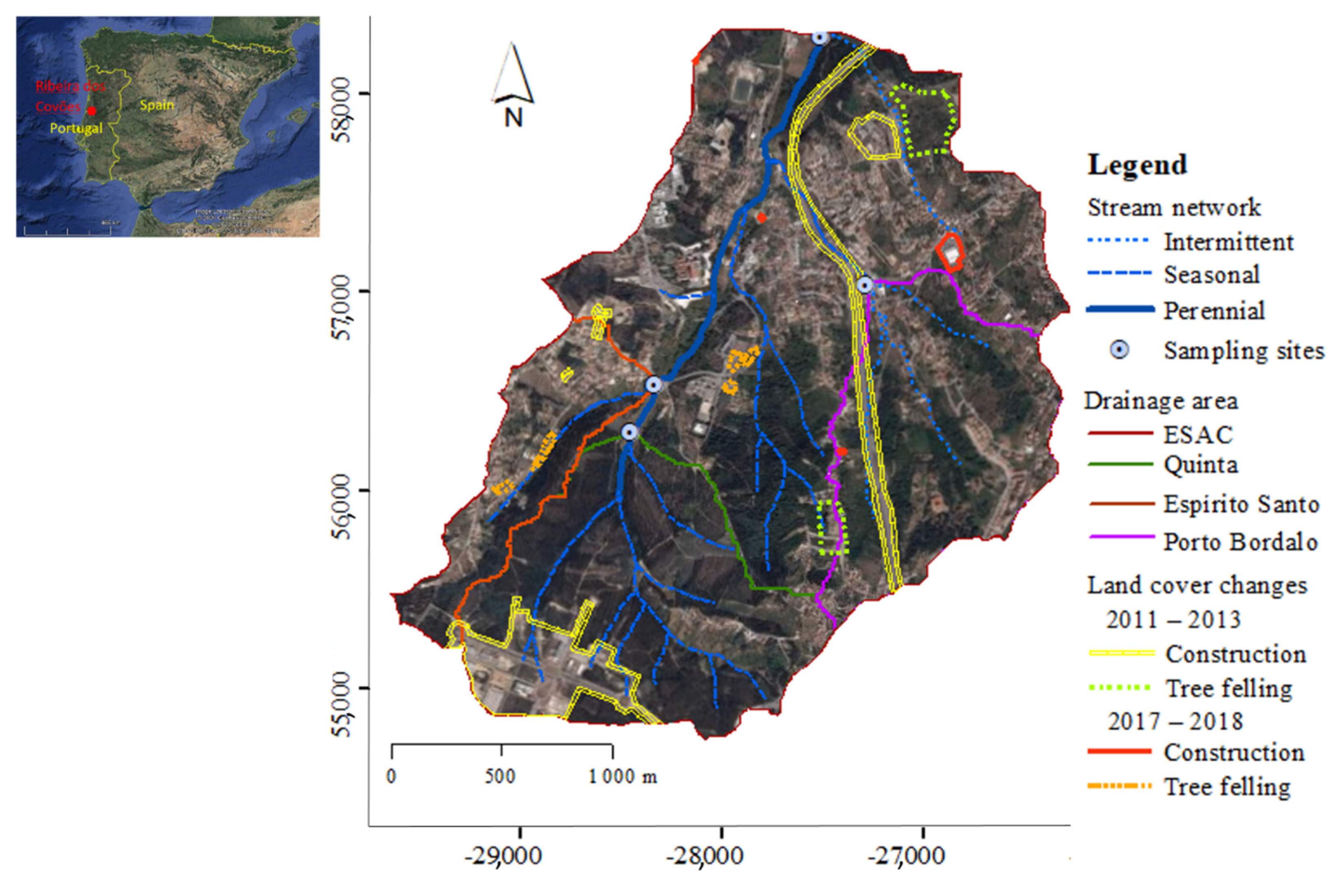
From 1950 to 2011, population increased from 14,315 to 26,632 inhabitants, and is currently mainly devoted to the tertiary sector [32]. The increase of population over the last few decades led to significant land use changes, mainly rural up to 1972 to around 40% urban, 56% forest and 4% agricultural by 2012. In 2012, major disturbance activities included the construction of (i) an Enterprise Park in the extreme southwest part of the catchment, covering about 5% of the catchment area, which started in late 2008 with deforestation; and (ii) a four-lane highway crossing the northwest part of the catchment (Figure 1). Some detached houses were also built in SE and NW urban areas and some deforestation in the middle part of the catchment were recorded (Figure 1). After 2013, land-use stabilized because of a national economic crisis. Since 2017, despite a recovery of the national economy, little further urbanization (and catchment land-use change) has occurred. In 2018, clear-felling of small areas of forest was carried out for fire protection purposes, as a consequence of new and stricter legislation regarding the control of biomass in forest areas, following severe wildfires recorded in 2017.
In general, urban development is dispersed over the catchment, comprising distinct urban cores of varying design and population density, and with differing storm drainage systems. In the Enterprise Park, a detention basin was constructed to collect runoff from upslope paved surfaces and delay its discharge into the stream during large storms. This detention basin also led sediment retention especially during the construction phase. Nevertheless, sediment fingerprinting evidence showed that bare soil surfaces within the Enterprise Park area were the main source of sediments at the catchment outlet in 2012, though less dominant in 2015 due to increasing vegetation cover [27].
2.2. Catchment and Sub-catchment Sampling Strategy
In order to investigate the spatial variability of suspended sediments, four sites within the Ribeira dos Covões catchment were selected for this study (Figure 1): the catchment outlet, ESAC, and three upstream sub-catchment sites draining areas of contrasting urban pattern. The three sub-catchments are (1) Quinta, with a relatively low urban area (22%) but including the Enterprise Park; (2) Espírito Santo, the most urbanized (49% urban), comprising mostly detached single-family houses, with relatively low surface sealing downslope and high imperviousness only in some upslope areas, with storm runoff infiltrating either in nearby or (after routing) downslope pervious areas (e.g., forest); and (3) Porto Bordalo, 39% urban, and comprising either rows of attached-houses or more closely packed detached houses with greater surface sealing, as well as part of the highway, with storm runoff from downslope impervious areas being piped directly to the stream. Quinta and Espírito Santo are located on sandstone whereas Porto Bordalo is in the limestone area. ESAC has a perennial flow regime, whereas Porto Bordalo has an ephemeral stream and Espírito Santo and Quinta have seasonal flows. The main characteristics of the four selected sites are summarised in Table 1.
The four selected sites form part of a hydrological monitoring network installed in Ribeira dos Covões catchment in 2010 [34]. Chemical aspects of stream water quality (notably nutrients and heavy metals) at the sites between October 2011 and March 2013 were reported in Ferreira et al. [35]. In another previous study [27], geochemical properties of fluvial bed sediments collected in 2012 and 2015 were used to explore spatial and temporal changes in sediment sources in the catchment, using the sediment fingerprinting approach.
Water samples were collected at the four sites (ESAC, Quinta, Espírito Santo and Porto Bordalo) during discrete storm events through (i) a period of active urbanization, from April 2011 to March 2013 (12 storms), and (ii) a period of relatively stable land-use, between November 2017 and December 2018 (11 storms). Sampling started immediately before the commencement of rainfall (whenever possible) in order to include pre-storm baseflow sediment content, and then covered rising limb, peak and falling limb sections of the hydrograph. In PB it was not possible to collect water samples prior to individual storms due to the ephemeral regime of the stream. The number of samples taken varied between storms and sampling sites, depending on rainstorm magnitude and discharge response.
The selection of storms was based on weather forecasts and deigned to include (i) the first rainstorms after the summer dry season, and (ii) winter wet season storms of differing magnitude and following contrasting antecedent weather. Water samples were collected manually from the middle of stream sections in 250-mL polyethylene bottles, and stored in a dark chilled cooler (∼4 °C) until reaching the laboratory. In total, 89 and 91 samples were collected at the catchment outlet (ESAC), 69 and 76 in Quinta, 67 and 87 in Espírito Santo and 83 and 90 in Porto Bordalo, during the urbanization and land-use stabilization periods, respectively.
Water level data recorded on dataloggers at 5-min intervals at each site were converted to discharge data using previously derived stage-discharge rating curves [34]. Then, 5-min rainfall data were provided by two rain gauges.
2.3. Laboratory Analysis
Total sediment (TS), including suspended sediment (SS, the portion of sediment retained by a filter) and dissolved sediment (TDS, the portion that passes through the filter), was analysed by the gravimetric method, after water evaporation (Method 2540-B) [36]. Electrical conductivity was measured in all the samples through potentiometric method (using a COND 51+ sensor). All samples were analysed in duplicate for each parameter, and mean values were used for data analyses.
For the samples collected during the land-use stabilization period, suspended sediment concentrations (SSC) were also quantified by filtering samples through pre-weighed 0.45 µm membranes, drying at 105 °C and reweighing (Method 2540-D) [36]. Suspended sediment concentrations for samples collected during the urbanization stage were estimated by subtracting TDS from TSC, where TDS was derived using site-specific linear regressions between TDS and specific conductance.
2.4. Data Analysis
Differences in TSC and SSC at the four sites (ESAC, Porto Bordalo, Espírito Santo and Quinta) were assessed for the urbanization and stabilization periods separately using the non-parametric Kruskal–Wallis H test, given the non-normal distribution of the data. For each site, temporal differences in TSC and SSC between the two periods were assessed using the Mann–Whitney U test. Statistically significant spatial and temporal differences were then further explored using the Least Significant Difference (LSD) post-hoc multiple comparison test. Statistical differences were evaluated at the 0.05 significance level. Linear correlations between sediment concentration variables and peak discharge, storm rainfall, maximum 15-min rainfall intensity (I15) and 7- and 14-day antecedent rainfall (API7 and API14, respectively) were assessed using Pearson r coefficients. Statistical analyses were performed in IBM SPSS Statistics 25 software.
3. Results
3.1. Rainfall Characteristics and Runoff Response During Monitored Storms
Storm rainfall characteristics and storm runoff coefficients in the active urbanization (2011–2013) and relatively stable land-use (2017–2018) periods at the four monitored sites are shown in Table 2. Storm rainfalls of analysed events ranged from 2.4 to 46.7 mm during urbanization and from 4.0 to 29.2 mm in the stabilization period, covering events with return periods of up to 2 years. Although the largest storm was recorded during urbanization (storm 12), a greater number of relatively large storms (> 10 mm) were monitored during the stabilization period. Nevertheless, differences in the rainfall amount and antecedent rainfall prior to each storm event (API7 and API14) recorded during urbanization and stabilization periods were not statistically significant (p > 0.05). In addition, a broadly similar range of rainfall intensities (I15) were experienced in both periods (p > 0.05).
Mean storm runoff coefficients were not significantly different between urbanization and stabilization periods for the four sampling sites (p > 0.05), although slightly lower in the latter period (Table 2). In general, storm runoff coefficients were greatest in Espírito Santo (3%–63%) (p < 0.05), with the largest urbanized contributing area, and similar between the other three sites (p > 0.05), although slightly lower in Quinta (0%–27%), with the smallest urban area. During the urbanization stage, the maximum storm runoff coefficient in Espírito Santo was twice as high as in the other sites, despite the active construction of the Enterprise Park in sub-catchment Quinta. Monitored storms included some of the first storms recorded after the summer, and no flow response was recorded in the sandstone Espírito Santo and Quinta sub-catchments, which become dry in summer, in storm 3 of the urbanization period and (in Quinta) in storm 13 of the stabilization period.
In all the four sites, peak discharge per storm was significantly correlated with event rainfall (r ranging from 0.89 for Porto Bordalo, p < 0.01, to 0.63 for Espírito Santo, p < 0.05) and I15 (r ranging from 0.88 for Quinta to 0.80 for Espírito Santo, p < 0.01) during the urbanization period. During the stabilization period, however, peak discharge was only correlated with I15 (r = 0.85–0.90, p < 0.01), except in the Quinta sub-catchment (p > 0.05).
3.2. Spatiotemporal Variation of Sediments
3.2.1. TSC and SSC Variations in the Urbanization and Stabilization Periods
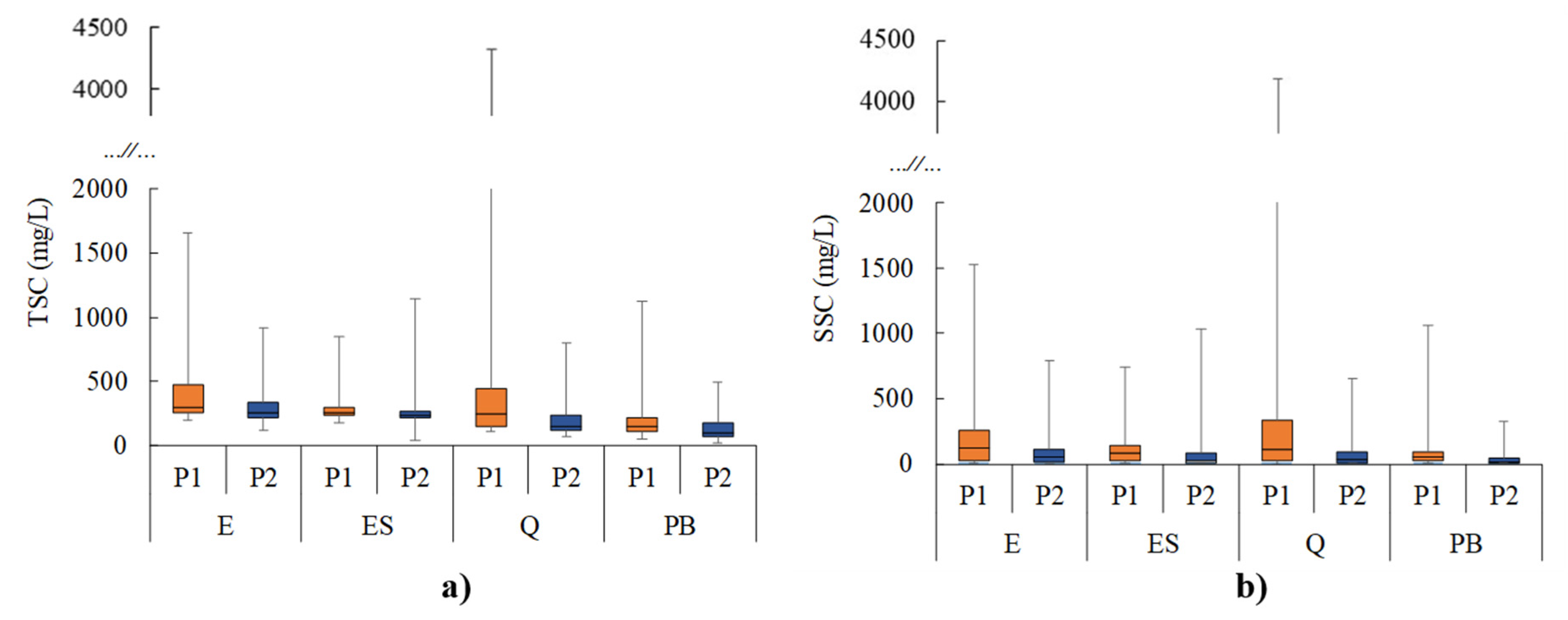
TSC showed significant differences between the four sites during both periods. In general, TSC was lower in the Porto Bordalo sub-catchment in both periods (median values of 153 mg/L and 105 mg/L, respectively) than in Quinta, Espírito Santo and ESAC (medians 250–300 mg/L during urbanization and 154–258 mg/L during stabilization) (Figure 2a). The Quinta sub-catchment undergoing major land-use changes provided similar TSC during urbanization to those recorded at the catchment outlet (E) (p > 0.05). During stabilization, however, TSC was significantly lower in Quinta than at ESAC (median values of 154 mg/L and 258 mg/L, respectively) (p < 0.05).
At all sites except Espírito Santo, there were significant differences in TSC between urbanization and stabilization periods (p < 0.05), with median TSC values in the stable period being 38%, 31% and 14% lower in Quinta, Porto Bordalo and ESAC, correspondingly, than during urbanization (Figure 3). The greater decrease occurred in the Quinta sub-catchment undergoing major land-use change. In contrast, the Espírito Santo sub-catchment displayed similar TSC in both periods (258 mg/L vs. 240 mg/L), since it was less affected by urbanization (p > 0.05).
Similar spatiotemporal variations were recorded in SSC, with lower values in Porto Bordalo during urbanization (52 mg/L) and stabilization (19 mg/L) than at the other three sites (20–120 mg/L) (Figure 2b). Despite similar median SSCs, the greater urbanization activity in Quinta led to higher peak SSC there than at the catchment outlet (ESAC) and Espírito Santo (p < 0.05). At Q, 75% of measurements were higher than at ESAC (339 mg/L in Quinta vs. 254 mg/L in ESAC), and the maximum concentrations were almost 3 times higher (4184 mg/L vs. 1525 mg/L). During the stabilization period, however, similar SSC were recorded at Quinta, ESAC and Espírito Santo (p < 0.05).
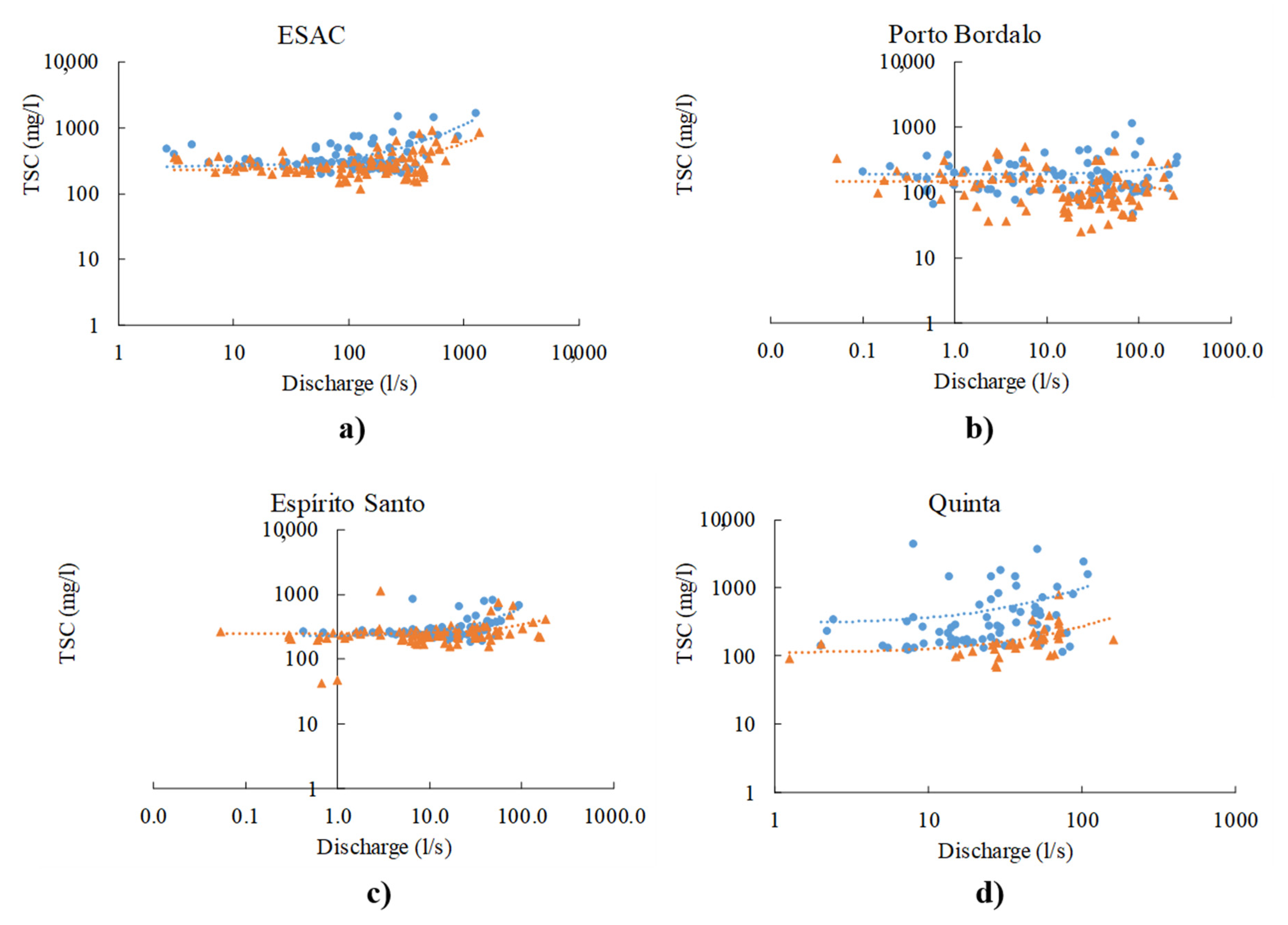
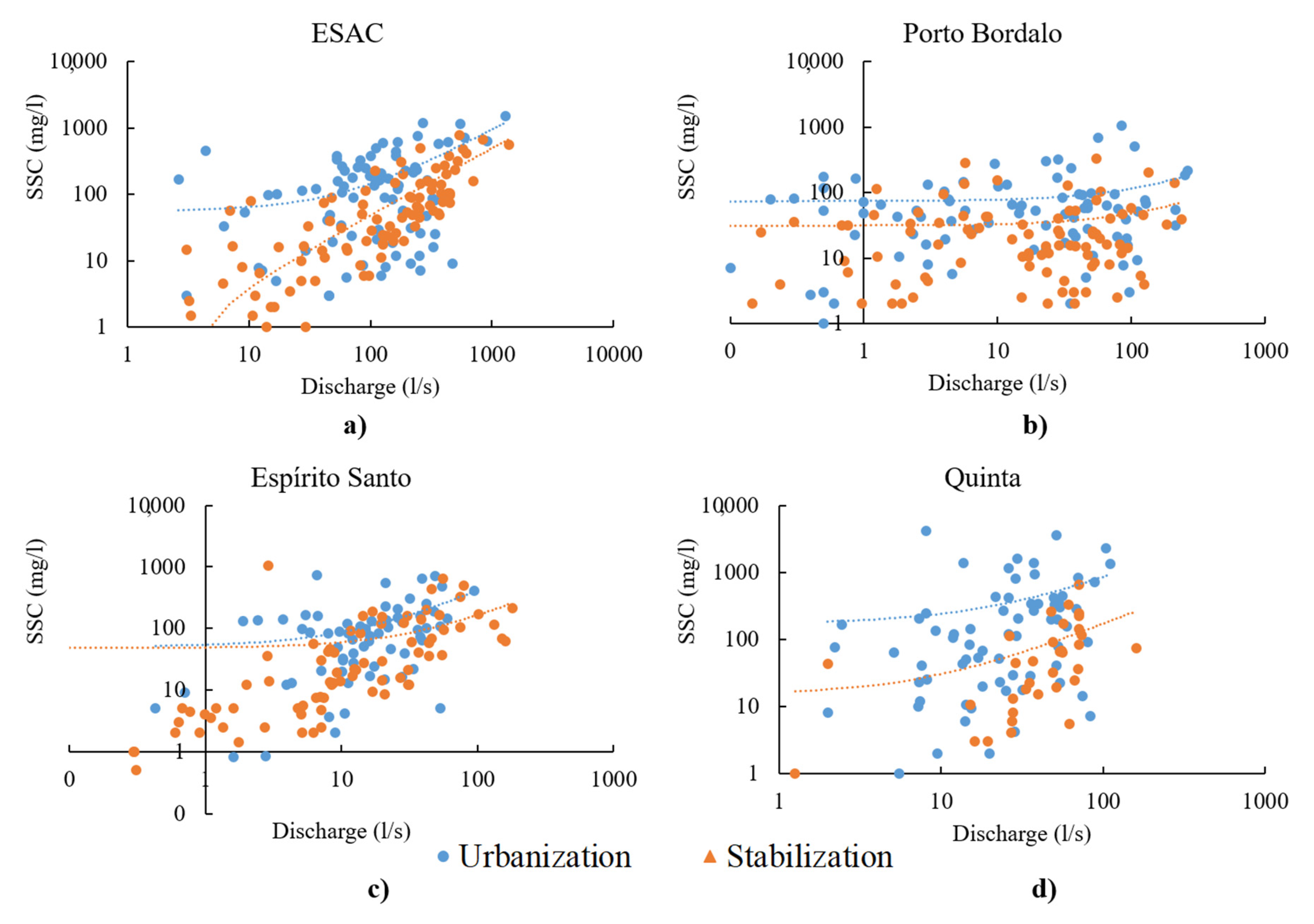
Falls in median SSC (as percentages of urbanization values) between the urbanization and stabilization periods attained 76% in Espírito Santo, 69% in Quinta, 64% in Porto Bordalo and 59% in ESAC. The greatest percentage decrease recorded at Espírito Santo (median falling from 84 mg/L to 20 mg/L) occurred despite only minor land-use change during the urbanization period (Figure 1). In Espírito Santo, SSC decreases were greater for higher then smaller discharges (Figure 4). However, Espírito Santo recorded a higher maximum SSC value during the ‘stabilization’ period (1033 mg/L) than the previous urbanization period (743 mg/L), probably because of some forest clear-felling close to the stream (Figure 2b).
The catchment outlet (ESAC) recorded the lowest percentage fall in median SSC from urbanization to stabilization (120 mg/L to 49 mg/L). This decrease was clearer under smaller than larger discharges, contrary to Espírito Santo (Figure 4). Similar findings were noticed also in ESAC and Quinta, although the decrease in the curve relating SSC and the discharge is not so sharp from urbanization to stabilization in Quinta regarding higher values. In Porto Bordalo the decrease in SSC from urbanization to stabilization periods were affected similarly under low and higher discharges. An indication of baseflow SSC is given by the values for the first sample of each storm event, e.g., before the rise in streamflow, and the medians of SSC values were much lower than the storm event values, but also showed a fall between urbanization and stabilization periods from 65 to 5 mg/L in ESAC, 75 to 22 mg/L in Espírito Santo and 45 to 32 mg/L in Quinta, and in Porto Bordalo from 33 to 17 mg/L. Suspended sediment represented a higher fraction of TSC during the urbanization than the stabilization period (Figure 2). In Q, affected by the construction of the large Enterprise Park, SSC represented in median 50% of TSC during urbanization, but only 22% during the stabilization period. In Porto Bordalo, SSC comprised 43% of the median TSC during the construction of the major road, covering 1.5% of the sub-catchment area, but only 19% of the median TSC during the stabilization period. A decrease in the proportion of SSC in TSC was also recorded at Espírito Santo (34% to 9%), despite little land-use change in either period. At the catchment outlet (ESAC), SSC represented 43% and 19% of TSC during the urbanization and stabilization periods, respectively.
3.2.2. Inter- and Intra-Storm Variations in SSC
Unsurprisingly, greatest SSC changes during storm events were recorded in the sub-catchment with greater land-use changes (Quinta), followed by the catchment outlet (ESAC), whereas Porto Bordalo (affected by the construction of the major highway) and Espírito Santo showed lower variability (Figure 5). During stabilization, however, highest SSCs and inter-storm variations were recorded in Espírito Santo, subject to clear-felling of trees close to the stream, followed by Quinta, ESAC and Porto Bordalo.
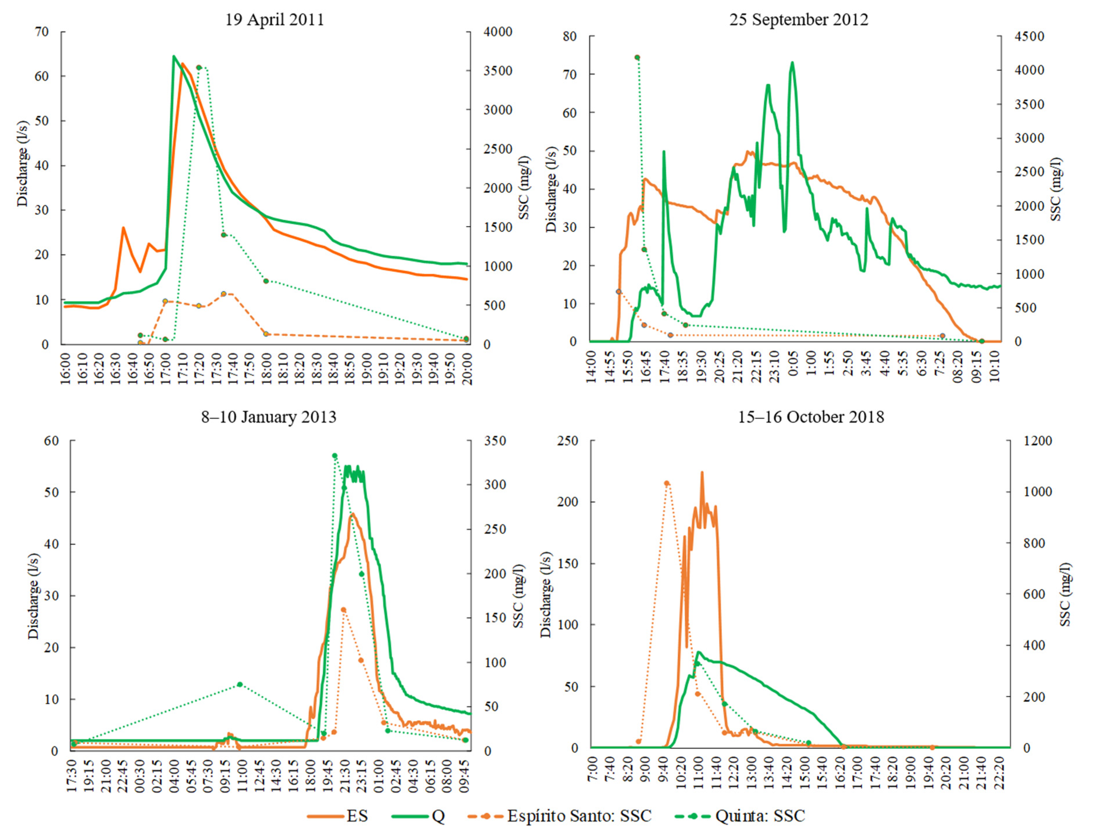
In general, largest intra-storm variation was perceived in the first storm events monitored after the dry summer, both in the urbanization (e.g., 2 November 2010, 14 November 2011, 25 September 2012) and stabilization periods (15 October 2018, 29 November 2018) (Figure 5). Maximum SSC values of 4184 mg/L and 743 mg/L were recorded at Quinta and Espírito Santo, respectively, on 25/09/2012 during urbanization. This rainfall event triggered the beginning of streamflow in both streams, leading to peak concentrations recorded during the initial stage of discharge and with no baseflow contribution. Nevertheless, median SSC under baseflow conditions were 156 mg/L in Quinta and 249 mg/L in Espírito Santo, during urbanization, highlighting the considerable increase to peak SSC. Nevertheless, in most other storms peak SSC occurred either immediately before (e.g., 19 April 2011) or after (e.g., 08–10 January 2013) peak discharge (Figure 6). During the stabilization period, Espírito Santo displayed highest SSC concentrations in 2018 from late spring (769 mg/L in 24 May 2018) to the first storm after the summer dry period (1144 mg/L in 15 October 2018) (Figure 5) in storm events that occurred after the forest clear-felling episode of early spring that year. Again, in these storms, peak SSC occurred at the beginning of runoff, in contrast to peak discharge timing typical in other events (Figure 6). As a result of this within-period variation, peak SSC in Espírito Santo was not significantly correlated with rainfall amount and intensity, in both urbanization and stabilization periods (p > 0.05).
For Quinta, peak SSC also tended to occur at the beginning of discharge for the initial storms after the summer, but was associated with peak discharge for other storms (Figure 6). In Quinta, peak SSC was significantly correlated with I15 during urbanization (r = 0.59, p < 0.05) and with both rainfall amount and maximum intensity during stabilization (r = 0.84, p < 0.01 and r = 0.70, p < 0.05, respectively).
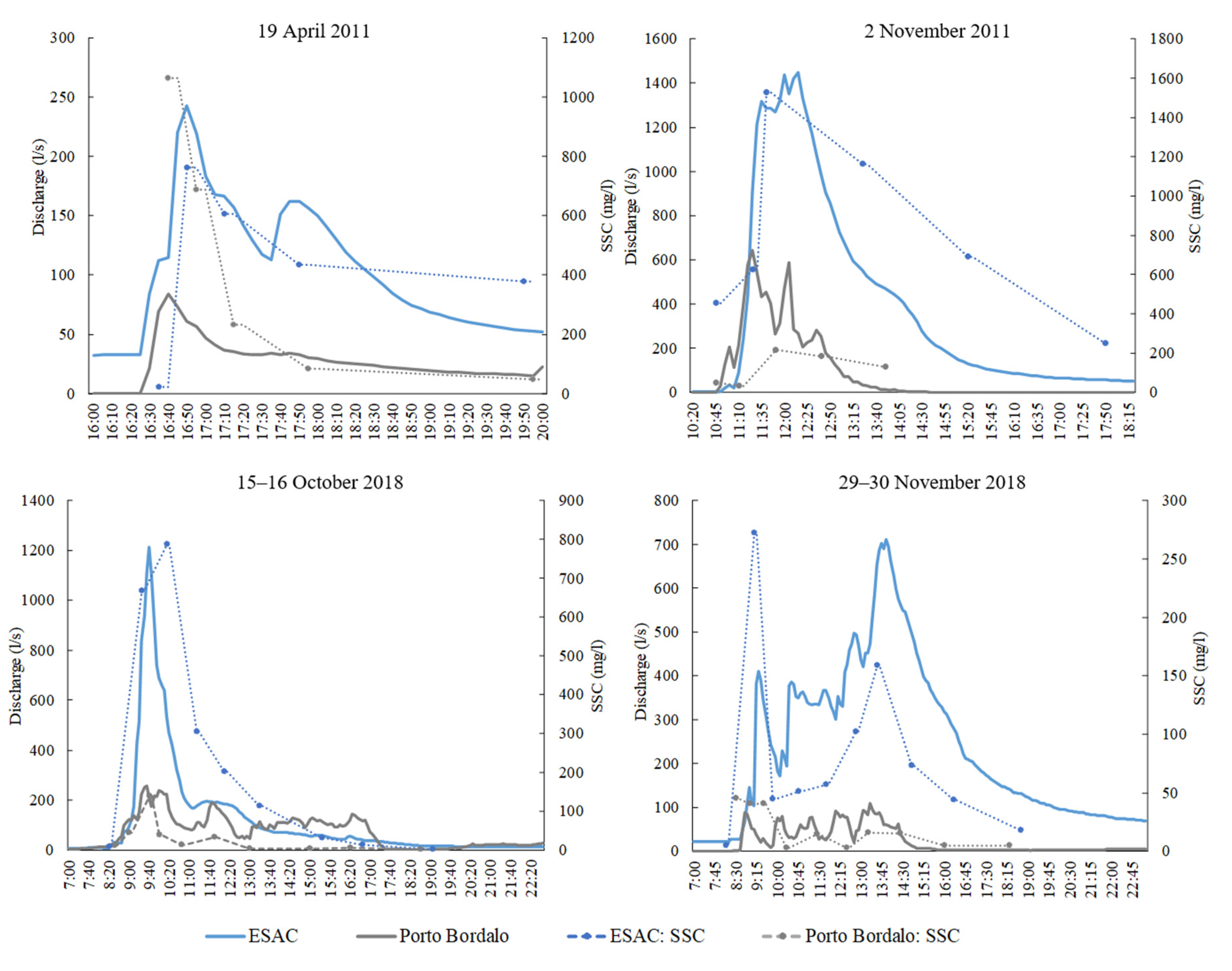
At the catchment outlet (ESAC), higher SSC values were also in part associated with the first storms after the summer (Figure 7), but also increasing from 23 October 2011 (729 mg/L) until 02 November 2011 (1656 mg/L) with increasing storm runoff coefficient (Table 2) during the urbanization period. In the stabilization period, SSC roses from 6 mg/L at baseflow to a peak of only 918 mg/L in the 15 October 2018 storm (the highest SSC recorded in 2017–2018) for a runoff coefficient (8%) similar to that recorded in the 02 November 2011 event. In most storm events, peak SSC was linked with peak discharge (e.g., 19 April 2011 and 02 November 2011), even in storms after the summer (e.g., 15–16 October 2018) (Figure 7). In ESAC, significant correlations were found between peak SSC and peak discharge and I15 during both the urbanization (r = 0.63, p < 0.05 and r = 0.82, p < 0.01, respectively) and stabilization (r = 0.78, p < 0.01 and r = 0.69, p < 0.05, respectively) periods.
In contrast to Quinta, Espírito Santo and ESAC, SSC variation in Porto Bordalo, which as an ephemeral flow regime, did not seem to be affected by the first storms after the summer (Figure 5). During urbanization, highest SSC was recorded in the 14 November 2011 event (598 mg/L), largely due to construction of a ditch just upstream of the gauging station. Additionally, the greatest intra-storm variation occurred in the wettest soil conditions of late winter (e.g., 19 April 2011 and 24 May 2018). Although SSC in Porto Bordalo generally increased with discharge (Figure 7), peak SSC per storm did not correlate significantly with peak discharge, storm rainfall or I15 (p > 0.05).
4. Discussion
4.1. Impact of Urbanization on Stream Sediments
As found elsewhere [5,37], suspended sediment (TSC and SSC) in the Ribeira dos Covões catchment are affected considerably by urbanization (2011–2013). The Quinta sub-catchment, which underwent the most intense disturbance in the first period despite having the smallest (22 %) urban area (Table 1), displayed highest TSC and SSC than the other sub-catchments (p < 0.05). During the urbanization period, deforestation and construction affected 17% of Quinta sub-catchment, and led to median TSC and SSC being about twice has high as those recorded in Porto Bordalo (Figure 2), despite the latter having twice the urban area (39%) and the active construction of a highway covering 1.5% of the area. In addition, 75% of the TSC and SSC measurements in Quinta were 1.5- and 2.4- times, respectively, the values in Espírito Santo, despite the much higher (but pre-existing) 49% urban area of the latter.
The maximum SSC of 4184 mg/L recorded in Quinta is twice as high as that recorded in a mixed land-use catchment with 30% urban area (2388 mg/L) in Missouri, USA [5]. In this Missouri catchment, median SSC increased by 98%, with a 22% increase in the urban land-use, over four-year period of study [5]. The relatively high impact on SSC from the construction site in Quinta is noticed, despite being reduced by part of the sediments was trapped within a retention basin. This infrastructure slows discharge of runoff from the Enterprise Park area into the stream network, and induces sedimentation, which field observation confirms is added to by the growth of dense vegetation within the retention basin. Since this type of structures is designed to retain water, although they favour sedimentation, additional measures to mitigate sediment loads are required, such as grade control structures [38].
During the urbanization period, maximum TSC and SSC in Porto Bordalo were 1.3- and 1.4- times greater than those recorded in Espírito Santo (Figure 2), may be a consequence of the construction of the highway road. Deposition of excavated soil during construction, however, created an unplanned retention basin which retained part of the runoff and sediments from this source. Field observation during events show that this unplanned basin decreases considerably both flow and sediment connectivity between the construction site and the stream network, despite their close proximity (Figure 1). This has mitigated the impact of urbanization on sediment dynamics as measured at the gauging station downstream. Specialized grading to increase surface roughness and reduce runoff velocity, however, provides an erosion protection measure used in previous projects [38].
At the catchment outlet (ESAC), TSC during urbanization was slightly higher than at Quinta and Espírito Santo (p > 0.05) (Figure 2), and twice as high as at Porto Bordalo. Similar results were also recorded for SSC, except that Quinta displayed higher concentrations than at ESAC (p < 0.05). Although a tendency for SSC to fall with downstream distance has been recorded in previous studies due to increasing dilution by additional runoff [5], sediment measurements from Ribeira dos Covões do tend to indicate that Quinta and Espírito Santo are the main sources of sediment to the catchment outlet. This also accords with previous findings in Ribeira dos Covões, based on geochemical sediment fingerprinting properties of deposited sediments [27].
Construction sites tend to provide significant sources of sediments when bare soil is exposed, leading to high SSC in the affected streams [2,6]. Thus, previous studies have reported that under active urbanization, sediment yields can be anything from 3–420 times than sediment yields in agricultural and forest areas and that fine-grained sediment yields can reach 21–12,000 times these background rates [6].
Finer sediments from construction sites are more easily available then coarser sediments and can be washed off quicker during the subsequent storms. The greatest percentage decrease in median SSC between the two monitored periods occurred at Espírito Santo (Figure 2). This may indicate that, despite the minor nature of urbanization period construction activities in Espírito Santo (Figure 1), there is a relatively high connectivity between the sites and the stream network, favoured by their downslope location and quick runoff and sediment transport via roads to nearby the outlet (confirmed by field observations). Nevertheless, during the stabilization stage, in Espírito Santo, forest clear-felling in spring 2018 close to the stream constituted a visible new source of sediment. The loose soil was easily washed off in the subsequent storms, leading to very high SSC maxima in storms recorded between May and October 2018 (Figure 5). Several previous studies have shown that deforestation can enhance erosion and suspended sediment by up to several orders of magnitude [36]. These findings also agree with previous authors reporting changes in sediment sources over short timescales [2].
Local measures to mitigate erosion should be implemented to reduce the impacts of disruptive land-use changes, such as construction works and forest clear-felling. Examples of soil erosion mitigation strategies include stabilization measures, such as seeding and mulching, and the installation of physical barriers, e.g., gravel bags, slit fences and straw rolls [38].
4.2. Spatiotemporal Dynamics of Sediments between Urbanization and Stabilization Periods
Human activities involving landscape disturbance, such as construction works and forest clear-felling, even if in small parts of the catchment, have impacts on sediment dynamics. Under relatively stable land-use conditions (2011–2013), the four monitored sites displayed lower TSC and SSC than during the urbanization period (Figure 3 and Figure 4), with similar arrays of rainstorm conditions (p > 0.05). Nevertheless, SSC decreases are more discernible at relatively low discharges in ESAC and Quinta, but at higher discharges in Espírito Santo. It is logical that anthropogenic disturbance sites and/or sources close to the stream network will lower the storm discharge threshold at which significant suspended sediment and runoff will be generated, as recorded in Quinta. It also would explain the greater percentage decrease in SSC from urbanization to stabilization phases at lower discharges (Figure 4). During larger storms, and consequent higher discharges, sediment sources more distant from the stream network may become relevant sources of sediments, such as may be the case of sediments from construction sites in Espírito Santo. Furthermore, other sediment sources over the catchment can become active only with increased soil saturation and flow connectivity in larger storms (especially in wet periods), thus explaining the smaller decreases in SSC during high discharges in ESAC (Figure 4).
In general, really high SSCs were experienced in just a few storms, particularly after the summer drought (Figure 5), associated with shorter but more intense rainstorms (Table 1), but also in some winter storms, notably those of 02 November 2011, 13 March 2018 and 24 May 2018 (Figure 5), with highest I15 (≈6 mm/h, Table 2). Rainfall intensity determines the available raindrop energy to erode surfaces, and runoff rate transport sediment [39]. Studies elsewhere have also reported the impact of few extreme events on very high SSC and total suspended sediment loads in relatively small rivers [17].
Storms recorded after the summer are characterized by peak SSCs that vary by several orders of magnitude depending on antecedent peak discharge (Figure 6 and Figure 7). During these storms, rainfall rapidly mobilizes sediments from active sources and/or dried, loose material in the dry sections of the drainage network. In addition, sediments transported from the hillslopes to low-order channels by relatively small early summer storms may remain stored until subsequent high flows, as described elsewhere by Gellis [37]. Peak discharge has been considered one of the key factors governing suspended sediment yields in small catchments [23].
Some studies have also reported sediment flushing from hillslopes and the channel during the first rainfall events after long dry periods [40], particularly from paved surfaces [41]. This may indicate that sediments are often supply limited instead of transport limited [17]. Thus, the meteorological and hydrologic characteristics of previous storms may influence sediment characteristics of the current storm [37]. The seasonal variation of sediment yields must be considered when planning land-use activities, such as urbanization and clear-felling. Some authors argue that scheduling activities that disturb established soil during the drier seasons, avoiding ground disturbance when water and wind are more likely, should be favoured [38]. This type of planning, however, must be considered carefully in climate regions such as the Mediterranean, recording short but high intensity storms immediately after the summer, since it may not be enough to mitigate erosion from construction sites effectively.
In the Ribeira dos Covões catchment, however, sediment dynamics differed between storms and sites. In Porto Bordalo, rises in SSC after the summer are less pronounced than at the other sites (Figure 5), possibly due to its ephemeral as rather than seasonal flow regime. At this site, high SSC values were recorded later in the wet season (e.g., 19 April 2011 and 13 March 2018, Figure 6 and Figure 7), possibly due to increased connectivity of runoff and sediments eroded from more distant sources. This type of sediment behaviour, associated with increasing connectivity over the wet season, has also been reported in studies elsewhere [37].
Differences in available sediment sources affected by land-use changes and in antecedent rainfall are relevant parameters influencing intra-storm sediment variations, including suspended sediment hysteresis [26]. Complex sediment patterns can be characterized by (i) clockwise hysteresis, when sediments increase during the rising limb and decrease during the falling limb of the hydrograph, as a result, for example, of rapid sediment flushing and depletion in the stream network; (ii) anti-clockwise hysteresis, when sediment increase is delayed, driven by, for example, sediments dilution with stormwater runoff on the rising limb and arrival of sediments from more distant sources; and (iii) other complex hysteresis associated with figure-eight loops, as a result of exhaustion of a particular sediment source during severe storms, differences in the arrival time of sediments from distinct sources which become connected with the river over the rainstorm, as well as storage and resuspension of sediments within the channel during storms [2,23,37]. Hysteresis analysis was not possible in the current study, because the frequency of sampling was insufficient during some of the events.
4.3. Impact of Different Urban Patterns on Sediment Dynamics
In the stabilization period, the previous major construction activities are still to some extent affecting stream sediment dynamics. Thus in 2017–2018, Quinta remains the sub-catchment with highest TSC and SSC (Figure 2), despite the percentage reductions of 38% and 69%, respectively, in median values compared with during the urbanization period. This is due to the extent of remaining erodible bare surface at these sites. Previous studies have also showed that most human interventions affect SSC over an extended period of time [2]. The high concentrations of sediments recorded in 2017-18 in Quinta stream, however, indicate also that the retention basin is not being very effective in trapping the fine suspended sediment fraction, such that SSCs at Quinta are now similar to those measured at the catchment outlet at ESAC (p > 0.05).
In contrast, in Porto Bordalo, containing the four-lane road construction site, SSC values in the stabilization period (median 19 mg/L) were much lower than in Quinta (Figure 2). The continued low SSC values in Espírito Santo in the second period, despite the sub-catchment having the highest (49 %) urban area and a forest-felling episode in Spring 2018 can be linked to the upslope location of the urban area, the detached house pattern and a lack of connectivity of runoff with the stream network. Studies elsewhere reported higher sediment concentrations from catchments with larger urban land-use [37]. Suspended sediment yields from urban catchments tend to be 2–70 times higher than background levels (in agriculture and forest) [6]. This is because stream channel erosion can persist longer after urban development, and because in some peri-urban areas gravel roads and parking areas can provide continuing sources of sediments to waterways [6]. Sealed surfaces, such as concrete and asphalt, can also be a relevant source of anthropogenic particles to streams, supplementing urban streams with coarser sediment loads [18,41].
The type of urban pattern and its location within the landscape can also affect overland flow and stream sediment supply and dynamics [29,40]. In Espírito Santo, runoff from upslope detached housing is mostly dissipated in surrounding pervious soil, enhancing water retention and infiltration opportunities. In contrast, in Porto Bordalo, runoff from its urban surfaces is partially piped to the stream network, thereby enhancing flow and sediment connectivity between the urban areas and the stream network [34]. This may explain the similar TSC and SSC of Porto Bordalo and Espírito Santo during the urbanization period, considering the unplanned retention basin downslope the road construction area in Porto BordaloB. Urban drainage systems are known to have a high sediment transport efficiency [2].
Lower sediment concentrations in Porto Bordalo may be also partially linked with its marly limestone soils, compared with the sandstone soils in the other upstream catchments. Analyses of fluvial sediments in Ribeira dos Covões showed that the limestone area (covering 40% of the catchment) only provided 10% of the sediments deposited at the catchment outlet [27]. Some authors have reported suspended sediment yields to be primarily dependent on geology and soil type, together with climate, land-use and position in the catchment [6,37].
At the catchment outlet (ESAC), median SSC during stabilization (49 mg/L) is lower than the median concentrations recorded during both wet (139-300 mg/L) and drier seasons (7–102 mg/L) in Hinkson Creek Watershed, Missouri, USA [5]. This watershed has similar annual rainfall (1036 mm) than the Ribeira dos Covões catchment, it is less urbanized (30% vs. 40%) and has an area 17 times higher (230 km2). In Missouri catchment, however, variations in estimated annual suspended sediment yields in individual years from 16 to 313 t/km2 were mainly attributed to differences in annual total precipitation, rather than urbanization [5]. This comparison between sites indicates a relatively acceptable suspended sediment situation during the stabilization period, but episodically rather high sediment levels during the urbanization phase (median SSC of 120 mg/L). However, sediments from urban areas in Ribeira dos Covões are associated with some pollutants, such as heavy metals, which may impair aquatic ecosystems [27]. In this study area, concentrations of Pb, Cu and Zn attained 155 mg/kg, 188 mg/kg and 659 mg/kg, respectively, in fluvial sediments derived from urban areas [27]. In 2018, a preliminary survey also identified and quantified some types of UV filters (e.g., octocrylene and ethylhexyltriazone) and parabens (e.g., methyl) in fluvial sediments over the Ribeira dos Covões catchment [42]. Thus, although sediment loads decreased during the stabilization period, the chemical load may be higher than during urbanization period.
In Portugal, as in other countries, no regulatory framework or legal guidelines for erosion control measures are established, thus no erosion control is performed in construction sites and/or clear-felled forest stands, and no specific measures to protect water bodies are implemented. Measurements to mitigate erosion are mandatory only for farmers receiving financial support to implement the Common Agricultural Policy. In the last years, however, Portuguese government is providing guidelines no mitigate soil erosion but only in wildfire affected areas. This lack of regulatory framework leads to high erosion rates over the landscape, leading, for example to siltation. In 2018, Coimbra municipality spent 4 million euros to remove ~700,000 m3 of sediments from a 3.2 km section of the Mondego river (just upstream of the confluence with Ribeira dos Covões catchment), where a dam was constructed in 1981.
A more complete understanding of the impacts of human disturbance, and the mosaic of urban types on sediment dynamics, and their chemical impact requires further investigation, namely in Ribeira dos Covões. Such information is relevant to mitigate degradation of aquatic ecosystems, and to establish efficient strategies to control erosion and reduce sediment loads and flood risk to the stream system. Simoni et al. [38] propose a structured conceptual planning approach, based on knowledge of hydrologic and sediment availability and sediment connectivity to channels, to design effective erosion and sediment flux mitigation measures. In some cases, such as those where sediment loads may impair water bodies used for human consumption, restrictions and prohibitions on land-use changes may be recommended, and used to integrate delimited safeguard zones into land-use planning [43].
5. Conclusions
Urbanization and distinct urban patterns affect sediment levels and fluxes in streams inside the peri-urban Ribeira dos Covões catchment. The construction of an Enterprise Park covering 17% of the Quinta sub-catchment led to 1.4-2.2 higher SSC than in the other two sub-catchments despite their much greater percentage urban area. Although the impact of the Enterprise Park construction was reduced by 69% (in terms of median storm SSC) in the 2017-18 stabilization period, the extent of bare soil surface in the Enterprise Park meant that the site (and the Quinta sub-catchment) remained the most important sediment source in the catchment. This was despite partial mitigation by the construction of a retention basin at the site.
The study shows that landscape disturbance, even in small parts of the catchment, are of great importance to sediment dynamics. In the Espírito Santo sub-catchment, the construction of a few houses also had an impact on stream suspended sediments, favoured by the effectiveness of roads in transporting runoff and sediments to downslope areas. In the same sub-catchment, a small area of forest clear-felling close to the stream also enhanced sediment concentrations in 2018, in storms over the subsequent six months. In Porto Bordalo sub-catchment, the construction of a four-lane highway covering 1.5% of the area also played a relevant role in TSC and SSC, despite significant mitigation due to an unintentional retention basin created by piles of spoil downslope of the construction site, which reduced connectivity with the stream network.
Apart from anthropogenic activities and land-use patterns, sediment dynamics are also affected by rainfall and discharge patterns. During both the urbanization and stabilization periods, suspended sediment concentrations were usually highest in storms recorded after the summer dry season associated with shorter but more intense rainstorms and increased sediment availability. Storm events later in the winter wet season, however, also led to high sediment fluxes, due to the role of increasing wetness in enhancing the connectivity between less active sediment sources and the stream network. This is more noticed in the limestone Porto Bordalo sub-catchment, than in the sandstone sub-catchments.
Mixed land-use mosaics provide distinct sources and sinks of runoff and sediments, reducing the connectivity of their fluxes downslope. Planners need to incorporate such spatial mosaic strategies, with urban areas located further from the stream network, to reduce downstream sediment problems. Furthermore, planning the best time of land-use changes, based on seasonal differences in peak sediment concentrations, together with the implementation of specific strategies to mitigate and retain sediments in source sites (e.g., construction sites and clear-felling forest stands), such as seedling and sediment traps, must be considered to develop a conceptual approach to mitigate sediment flux control and natural hazard risk mitigation.
Author Contributions
C.S.S.F. performed the field and laboratorial work and wrote the manuscript; R.P.D.W. supervised the research and supported the writing of the manuscript; Z.K. reviewed and edited the manuscript; A.J.D.F. supervised the research. All authors have read and agreed to the published version of the manuscript.
Funding
This research was funded by the Portuguese Science and Technology Foundation through the post-doctoral research grant of Carla Ferreira (SFRH/BPD/120093/2016).
Acknowledgments
The authors are grateful to Jaydeth Nascimento and Adélcia Veiga for technical support in the laboratory analysis.
Conflicts of Interest
The authors declare no conflict of interest.
References
- Communication from the Commission to the Council, the European Parliament, the European Economic and Social Committee and the Committee of Regions. In Thematic Strategy for Soil Protection (COM 2006.231); Commission of the European Communities: Brussels, Belgium, 2006.
- Vercruysse, K.; Grabowski, R.C.; Rickson, R.J. Suspended sediment transport dynamics in rivers: Multi-scale drivers of temporal variation. Earth-Sci. Rev. 2017, 166, 38–52. [Google Scholar] [CrossRef] [Green Version]
- Gray, A.B. The impact of persistent dynamics on suspended sediment load estimation. Geomorphology 2018, 322, 132–147. [Google Scholar] [CrossRef]
- Duan, W.; Takara, K.; He, B.; Luo, P.; Nover, D.; Yamashiki, Y. Spatial and temporal trends in estimates of nutrient and suspended sediment loads in the Ishikari River, Japan, 1985 to 2010. Sci. Total Environ. 2013, 461–462, 499–508. [Google Scholar] [CrossRef] [PubMed]
- Zeiger, S.; Hubbart, J.A. Quantifying suspended sediment flux in a mixed-land-use urbanizing watershed using a nested-scale study design. Sci. Total Environ. 2016, 542, 315–323. [Google Scholar] [CrossRef]
- Russell, K.L.; Vietz, G.J.; Fletcher, T.D. Global sediment yields from urban and urbanizing watersheds. Earth-Sci. Rev. 2017, 168, 73–80. [Google Scholar] [CrossRef]
- Atasoy, M.; Palmquist, R.B.; Phaneuf, D.J. Estimating the effects of urban residential development on water quality using microdata. J. Environ. Manag. 2006, 79, 399–408. [Google Scholar] [CrossRef]
- Shojaeezadeh, S.A.; Nikoo, M.R.; McNamara, J.P.; AghaKouchak, A.; Sadegh, M. Stochastic modeling of suspended sediment load in alluvial rivers. Adv. Water Resour. 2018, 119, 188–196. [Google Scholar] [CrossRef]
- Mukherjee, D.P. Dynamics of metal ions in suspended sediments in Hugli estuary, India and its importance towards sustainable monitoring program. J. Hydrol. 2014, 517, 762–776. [Google Scholar] [CrossRef]
- Wijesiri, B.; Liu, A.; Deilami, K.; He, B.; Hong, N.; Yang, B.; Zhao, X.; Ayoko, G.; Goonetilleke, A. Nutrients and metals interactions between water and sediment phases: An urban river case study. Environ. Pollut. 2019, 251, 354–362. [Google Scholar] [CrossRef]
- Yu, S.; Wu, Q.; Li, Q.; Gao, J.; Lin, Q.; Ma, J.; Xu, Q.; Wu, S. Anthropogenic land uses elevate metal levels in stream water in an urbanizing watershed. Sci. Total Environ. 2014, 488–489, 61–69. [Google Scholar] [CrossRef]
- Dias-Ferreira, C.; Pato, R.L.; Varejão, J.B.; Tavares, A.O.; Ferreira, A.J.D. Heavy metal and PCB spatial distribution pattern in sediments within an urban catchment—Contribution of historical pollution sources. J. Soils Sediments 2016, 11, 1–12. [Google Scholar] [CrossRef]
- European Environmental Agency (EEA). European Waters—Assessment of Status and Pressures 2018; EEA Report No 7/2018; Environmental Protection Agency: Luxembourg, 2018; Available online: https://www.eea.europa.eu/publications/state-of-water (accessed on 1 December 2019).
- United States Environmental Protection Agency (USEPA). Water Quality Assessment and TMDL Information. Available online: https://iaspub.epa.gov/waters10/attains_index.home (accessed on 2 September 2019).
- Miller, J.R.; Ferri, K.; Grow, D.; Villarroel, L. Hydrologic, geomorphic, and stratigraphic controls on suspended sediment transport dynamics, Big Harris Creek restoration site, North Carolina, USA. Anthropocene 2019, 25, 100188. [Google Scholar] [CrossRef]
- Ehteram, M.; Ghotbi, S.; Kisi, O.; Ahmed, A.N.; Salih, G.H.A.; Fai, C.M.; Krishnan, M.; EL-Shfie, A. River Suspended Sediment Prediction Using Improved ANFIS and ANN Models: Comparative Evaluation of the Soft Computing Models. Water 2019, 11. in press. [Google Scholar]
- Tramblay, Y.; Saint-Hilaire, A.; Ouarda, T.B.M.J.; Moatar, F.; Hecht, B. Estimation of local extreme suspended sediment concentrations in California Rivers. Sci. Total Environ. 2010, 408, 4221–4229. [Google Scholar] [CrossRef] [Green Version]
- Ferreira, C.S.S.; Moruzzi, R.; Isidoro, J.M.G.P.; Tudor, M.; Vargas, M.; Ferreira, A.J.D.; de Lima, J.L.M.P. Impacts of distinct spatial arrangements of impervious surfaces on runoff and sediment fluxes from laboratory experiments. Anthropocene 2019, 28, 100219. [Google Scholar] [CrossRef]
- Mao, L.; Carrillo, R. Temporal dynamics of suspended sediment transport in a glacierized Andean basin. Geomorphology 2017, 287, 116–125. [Google Scholar] [CrossRef]
- Oliveira, K.S.S.; Quaresma, V.S. Temporal variability in the suspended sediment load and streamflow of the Doce River. J. South Am. Earth Sci. 2017, 78, 101–115. [Google Scholar] [CrossRef]
- Gray, A.B.; Pasternack, G.B.; Watson, E.B.; Warrick, J.A.; Goñi, M.A. Effects of antecedent hydrologic conditions, time dependence, and climate cycles on the suspended sediment load of the Salinas River, California. J. Hydrol. 2015, 525, 632–649. [Google Scholar] [CrossRef] [Green Version]
- Peña-Angulo, D.; Nadal-Romero, E.; Gonzalez-Hidalgo, J.C.; Albaladejo, J.; Andreu, V.; Bagarello, V.; Barhi, H.; Batalla, R.J.; Bernal, S.; Gienes, R.; et al. Spatial variability of the relationships of runoff and sediment yield with weather types throughout the Mediterranean basin. J. Hydrol. 2019, 571, 390–405. [Google Scholar]
- Esteves, M.; Legout, G.; Navratil, O.; Evrard, O. Medium term high frequency observation of discharges and suspended sediment in a Mediterranean mountainous catchment. J. Hydrol. 2019, 568, 562–574. [Google Scholar] [CrossRef]
- Walling, D.E. Tracing suspended sediment sources in catchments and river systems. Sci. Total Environ. 2005, 344, 159–184. [Google Scholar] [CrossRef] [PubMed]
- Hammer, T.R. Stream channel enlargement due to urbanization. Water Resour. Res. 1972, 8, 1530–1540. [Google Scholar] [CrossRef]
- Kemper, J.T.; Miller, A.J.; Welty, C. Spatial and temporal patterns of suspended sediment transport in nested urban watersheds. Geomorphology 2019, 336, 95–106. [Google Scholar] [CrossRef]
- Ferreira, C.S.S.; Walsh, R.P.D.; Blake, W.H.; Kikuchi, R.; Ferreira, A.J.D. Temporal dynamics of sediment sources in an urbanizing Mediterranean catchment. Land Degrad. Dev. 2017, 28, 2354–2369. [Google Scholar] [CrossRef]
- Ferreira, C.S.S.; Walsh, R.P.D.; Steenhuis, T.S.; Shakesby, R.A.; Nunes, J.P.N.; Coelho, C.O.A.; Ferreira, A.J.D. Spatiotemporal variability of hydrologic soil properties and the implications for overland flow and land management in a peri-urban Mediterranean catchment. J. Hydrol. 2015, 525, 249–263. [Google Scholar] [CrossRef] [Green Version]
- Ferreira, C.S.S.; Walsh, R.P.D.; Nunes, J.P.C.; Steenhuis, T.S.; Nunes, M.; de Lima, J.L.M.P.; Coelho, C.O.A.; Ferreira, A.J.D. Impact of urban development on streamflow regime of a Portuguese peri-urban Mediterranean catchment. J. Soils Sediments 2016, 16, 2580–2593. [Google Scholar] [CrossRef]
- Kalantari, Z.; Ferreira, C.S.S.; Walsh, R.P.D.; Ferreira, A.J.D.; Destouni, G. Urbanization development under climate change: Hydrological responses in a peri-urban Mediterranean catchment. Land Degrad. Dev. 2017, 28, 2207–2221. [Google Scholar] [CrossRef] [Green Version]
- European Environment Agency. The European Environment—State and Outlook 2015; Synthesis Report; European Environment Agency: Copenhagen, Denmark, 2015; Available online: https://www.eea.europa.eu//soer-2015/synthesis/report (accessed on 28 December 2019).
- Instituto Nacional de Estatística. IX Recenseamento Geral da População; Instituto Nacional de Estatística: Lisboa, Portugal, 2011. (In Portuguese) [Google Scholar]
- Google Earth. Image Landsat/Copernicus; US Department of State Geographer: New York, WA, USA, 2019; Available online: https://www.eea.europa.eu/publications/state-of-water (accessed on 30 November 2019).
- Ferreira, C.S.S.; Walsh, R.P.D.; Steenhuis, T.S.; Ferreira, A.J.D. Effect of Peri-urban Development and Lithology on Streamflow in a Mediterranean Catchment. Land Degrad. Dev. 2018, 29, 1141–1153. [Google Scholar] [CrossRef]
- Ferreira, C.S.S.; Walsh, R.P.D.; Costa, M.L.; Coelho, C.O.A.; Ferreira, A.J.D. Dynamics of surface water quality driven by distinct urbanization patterns and storms in a Portuguese peri-urban catchment. J. Soils Sediments 2016, 16, 2606–2621. [Google Scholar] [CrossRef] [Green Version]
- Baird, R.B.; Eaton, A.D.; Rice, E.W. Standard Methods for the Examination of Water and Wastewater, 20th ed.; American Public Health Association, American Water Works Association and Water Environment Federation: Washington, DC, USA, 1998. [Google Scholar]
- Gellis, A.C. Factors influencing storm-generated suspended-sediment concentrations and loads in four basins of contrasting land use; humid-tropical Puerto Rico. Catena 2013, 104, 39–57. [Google Scholar] [CrossRef]
- Simoni, S.; Vignoli, G.; Mazzorana, B. Enhancing sediment flux control and natural hazard risk mitigation through a structured conceptual planning approach. Geomorphology 2017, 291, 159–173. [Google Scholar] [CrossRef]
- Barco, J.; Hogue, T.S.; Curto, V.; Rademacher, L. Linking hydrology and stream geochemistry in urban fringe watersheds. J. Hydrol. 2008, 360, 31–47. [Google Scholar] [CrossRef]
- Helsel, D.R. Land Use Influences on Heavy Metals in an Urban Reservoir System; NTIS PB-296 724; Department of Commerce: New York, WA, USA, 1978; Available online: https://books.google.pt/books?id=Hx_ApCXk9LMC&pg=PA1206&lpg=PA1206&dq=Land+Use+Influences+on+Heavy+Metals+in+an+Urban+Reservoir+System (accessed on 2 January 2019).
- Ferreira, A.J.D.; Soares, D.; Serrano, L.M.V.; Walsh, R.P.D.; Ferreira, C.M.D.; Ferreira, C.S.S. Roads as sources of heavy metals in urban areas. The Covões Catchment experiment; Coimbra; Portugal. J. Soils Sediments 2016, 16, 2622–2639. [Google Scholar] [CrossRef]
- Ferreira, C.S.S.; Apel, C.; Bento, C.; Koetke, D.; Ferreira, A.J.D.; Ebinghaus, R. Assessment of UV Filters and Parabens in a small Portuguese Peri-urban catchment. Proceedings 2019, 30, 30. [Google Scholar] [CrossRef] [Green Version]
- Restrepo, J.D.; Kettner, A.J.; Syvitski, J.P.M. Recent deforestation causes rapid increase in river sediment load in the Colombian Andes. Anthropocene 2015, 10, 13–28. [Google Scholar] [CrossRef]
Figure 1.
Location of the Ribeira dos Covões catchment in Portugal and the Iberian Peninsula (left), and the sampling sites (right) at the outlet (ESAC) and in three upstream sub-catchments (Quinta, Espírito Santo and Porto Bordalo). Additionally, shown are sub-catchment boundaries and the location of the main land use/cover interventions during the urbanization (2011–2013) and stabilization (2017–2018) periods. (Adapted from [33]).

Figure 2.
Box plots (median, upper (75) and lower (25) quartiles, maximum and minimum) showing the concentration of total sediment (TSC) (a) and suspended sediment (SSC) (b) in the four study sites (E: ESAC, ES: Espírito Santo, Q: Quinta, PB: Porto Bordalo), during urbanization (P1) and stabilization (P2) periods.

Figure 3.
Relation between discharge and total sediment concentration (TSC) in the ESAC (a) Porto Bordalo; (b) Espírito Santo; (c) and Quinta; (d) sampling sites during urbanization and stabilization periods.
Figure 3.
Relation between discharge and total sediment concentration (TSC) in the ESAC (a) Porto Bordalo; (b) Espírito Santo; (c) and Quinta; (d) sampling sites during urbanization and stabilization periods.

Figure 4.
Relation between suspended sediment concentration (SSC) in the ESAC (a) Porto Bordalo; (b) Espírito Santo; (c) Quinta; (d) sampling sites during urbanization and stabilization periods.
Figure 4.
Relation between suspended sediment concentration (SSC) in the ESAC (a) Porto Bordalo; (b) Espírito Santo; (c) Quinta; (d) sampling sites during urbanization and stabilization periods.

Figure 5.
Temporal variability of suspended sediment concentration (SSC) and runoff depth between the four study sites. Dashed lines divide urbanization (2011–2013) and relatively stable land-use (2017–2018) periods. Note scale difference in Quinta regarding SSC.
Figure 5.
Temporal variability of suspended sediment concentration (SSC) and runoff depth between the four study sites. Dashed lines divide urbanization (2011–2013) and relatively stable land-use (2017–2018) periods. Note scale difference in Quinta regarding SSC.

Figure 6.
Variation of SSC and discharge in Espírito Santo (ES) and Quinta (Q) sub-catchments during contrasting storms, including under wettest season (19 April 2011 and 8–10 January 2013) and at the end of summer (25 September 2012 and 15–16 October 2018).
Figure 6.
Variation of SSC and discharge in Espírito Santo (ES) and Quinta (Q) sub-catchments during contrasting storms, including under wettest season (19 April 2011 and 8–10 January 2013) and at the end of summer (25 September 2012 and 15–16 October 2018).

Figure 7.
Variation of SSC and discharge at the catchment outlet (ESAC) and in the ephemeral stream Porto Bordalo in distinct storms.
Figure 7.
Variation of SSC and discharge at the catchment outlet (ESAC) and in the ephemeral stream Porto Bordalo in distinct storms.


Table 1.
Main topographical, lithological, land-use (in 2016) and hydrological characteristics of the catchment and sub-catchments investigated in Ribeira dos Covões (adapted from [34]).
Table 1.
Main topographical, lithological, land-use (in 2016) and hydrological characteristics of the catchment and sub-catchments investigated in Ribeira dos Covões (adapted from [34]).
| ESAC–(Outlet) | Porto Bordalo | Espírito Santo | Quinta | |
|---|---|---|---|---|
| Area (ha) | 620 | 113 | 56 | 150 |
| Mean slope (°) | 10 | 12 | 8 | 4 |
| Sandstone (%) | 56 | 2 | 98 | 100 |
| Limestone (%) | 41 | 98 | 0 | 0 |
| Alluvial (%) | 3 | 0 | 2 | 0 |
| Urban (%) | 40 | 39 | 49 | 22 |
| Woodland (%) | 56 | 57 | 46 | 73 |
| Agriculture (%) | 4 | 4 | 5 | 5 |
| Stream classification | Perennial | Ephemeral | Seasonal | Seasonal |
| Mean annual runoff (%) | 14–21 | 11–12 | 26–31 | 13–14 |
| Mean annual surface runoff (%) | 9–13 | 8–9 | 20–21 | 8–9 |
| Baseflow index (%) | 36–39 | 1–2 | 23–29 | 33–39 |
| Gauge elevation (m) | 32 | 73 | 81 | 83 |
Table 2.
Rainfall characteristics and runoff response during the 12 and 11 storms monitored during the urbanization and stabilization periods (a: storms recorded after the summer; I15: maximum rainfall intensity during 15 min; API7: 7-day antecedent rainfall; API14: 14-day antecedent rainfall; E: catchment outlet; PB: Porto Bordalo; ES: Espírito Santo; Q: Quinta).
| Storm | Date | Rainfall | Runoff Coefficient (%) | |||||||
|---|---|---|---|---|---|---|---|---|---|---|
| Depth (mm) | I15 (mm/h) | API7 (mm) | API14 (mm) | E | PB | ES | Q | |||
| Urbanization | 1 | 19 April 2011 | 4.2 | 2.4 | 20.7 | 20.7 | 5.6 | 8.2 | 15.0 | 5.4 |
| 2 | 29 April 2011 | 3.4 | 0.6 | 4.8 | 39.1 | 4.3 | 6.6 | 5.3 | 2.6 | |
| 3 a | 23–24 October 2011 | 7.6 | 1.6 | 1.8 | 1.9 | 3.5 | 5.5 | 0.0 | 0.0 | |
| 4 a | 26 October 2011 | 3.8 | 0.9 | 28.8 | 28.9 | 5.0 | 4.9 | 17.8 | 5.0 | |
| 5 | 02 November 2011 | 24.0 | 6.0 | 20.7 | 48.8 | 8.6 | 9.4 | 7.8 | 9.3 | |
| 6 | 14 November 2011 | 5.3 | 2.7 | 35.5 | 97.9 | 19.0 | 14.4 | 24.9 | 11.1 | |
| 7 | 16 December 2011 | 3.6 | 1.1 | 19.7 | 22.0 | 5.3 | 2.8 | 7.2 | 4.2 | |
| 8 | 04 May 2012 | 2.4 | 0.9 | 47.7 | 85.4 | 17.1 | 5.8 | 13.7 | 11.9 | |
| 9 a | 25–26 September 2012 | 6.4 | 1.7 | 15.6 | 15.6 | 20.3 | 30.2 | 62.7 | 18.2 | |
| 10 | 08–10 January 2013 | 9.0 | 1.0 | 0.0 | 7.5 | 5.6 | 5.1 | 20.5 | 9.7 | |
| 11 | 15–17 January 2013 | 20.2 | 1.5 | 25.3 | 25.3 | 11.3 | 8.5 | 23.7 | 13.1 | |
| 12 | 25–29 March 2013 | 46.7 | 2.8 | 51.8 | 75.2 | 29.4 | 26.2 | 31.7 | 23.0 | |
| Mean values | 11.4 | 1.9 | 22.7 | 39.0 | 11.3 | 10.6 | 19.2 | 9.5 | ||
| Stabilization | 13 a | 02 November 2017 | 4.0 | 1.0 | 0.4 | 8.0 | 2.0 | 15.9 | 3.4 | 0.0 |
| 14 | 05 March 2018 | 9.0 | 2.4 | 113.8 | 114.2 | 19.6 | 2.6 | 23.3 | 16.0 | |
| 15 | 09 March 2018 | 7.2 | 1.2 | 64.4 | 134.8 | 17.4 | 2.8 | 25.0 | 11.1 | |
| 16 | 13 March 2018 | 14.0 | 5.2 | 46.6 | 155.0 | 20.4 | 6.5 | 22.1 | 27.4 | |
| 17 | 24 May 2018 | 29.2 | 5.8 | 7.2 | 2.4 | 7.3 | 3.7 | 9.6 | 15.1 | |
| 18 | 08 June 2018 | 20.8 | 1.6 | 13.6 | 18.8 | 16.3 | 5.6 | 14.2 | 14.7 | |
| 19 a | 15 October 2018 | 13.8 | 4.4 | 14.8 | 15.0 | 8.4 | 37.8 | 15.4 | 5.1 | |
| 20 | 29 October 2018 | 16.8 | 2.2 | 0.2 | 11.0 | 3.8 | 11.1 | 6.4 | 6.2 | |
| 21 | 08 November 2018 | 6.2 | 0.8 | 47.0 | 64.6 | 10.9 | 20.8 | 11.6 | 6.5 | |
| 22 | 29 November 2018 | 16.3 | 1.6 | 46.4 | 66.6 | 17.2 | 10.5 | 32.1 | 22.1 | |
| 23 | 18 December 2018 | 7.8 | 1.6 | 32.0 | 33.6 | 15.8 | 5.6 | 36.8 | 8.3 | |
| Mean values | 13.2 | 2.5 | 35.1 | 56.7 | 12.6 | 11.2 | 18.2 | 12.0 | ||
© 2020 by the authors. Licensee MDPI, Basel, Switzerland. This article is an open access article distributed under the terms and conditions of the Creative Commons Attribution (CC BY) license (http://creativecommons.org/licenses/by/4.0/).
Share and Cite
MDPI and ACS Style
Ferreira, C.S.S.; Walsh, R.P.D.; Kalantari, Z.; Ferreira, A.J.D. Impact of Land-Use Changes on Spatiotemporal Suspended Sediment Dynamics within a Peri-Urban Catchment. Water 2020, 12, 665. https://doi.org/10.3390/w12030665
AMA Style
Ferreira CSS, Walsh RPD, Kalantari Z, Ferreira AJD. Impact of Land-Use Changes on Spatiotemporal Suspended Sediment Dynamics within a Peri-Urban Catchment. Water. 2020; 12(3):665. https://doi.org/10.3390/w12030665
Chicago/Turabian StyleFerreira, C.S.S., R.P.D. Walsh, Z. Kalantari, and A.J.D. Ferreira. 2020. "Impact of Land-Use Changes on Spatiotemporal Suspended Sediment Dynamics within a Peri-Urban Catchment" Water 12, no. 3: 665. https://doi.org/10.3390/w12030665
Note that from the first issue of 2016, this journal uses article numbers instead of page numbers. See further details here.