Bridging Terrestrial and Marine Geoheritage: Assessing Geosites in Portofino Natural Park (Italy)
by
 , , and
Paola Coratza
1 ,
,
Vittoria Vandelli
1,*,
Lara Fiorentini
2,
Guido Paliaga
3 and
Francesco Faccini
3,4
1
Dipartimento di Scienze Chimiche e Geologiche, Università degli Studi di Modena e Reggio Emilia, Via Campi 103, 41125 Modena, Italy
2
Settore Politiche delle Aree interne, Antincendio, Forestazione, Parchi e Biodiversità, Regione Liguria, Via D’Annunzio 111, 16121 Genova, Italy
3
CNR Istituto di Ricerca per la Protezione Idrogeologica, sede di Torino, Strada delle Cacce 73, 10135 Torino, Italy
4
Dipartimento di Scienze della Terra, dell’Ambiente e della Vita, Università degli Studi di Genova, Corso Europa 26, 16132 Genova, Italy
*
Author to whom correspondence should be addressed.
Water 2019, 11(10), 2112; https://doi.org/10.3390/w11102112
Submission received: 28 August 2019
/
Revised: 6 October 2019
/
Accepted: 8 October 2019
/
Published: 11 October 2019
(This article belongs to the Special Issue Landscapes and Landforms of Terrestrial and Marine Areas)
Abstract
:Interest in geoheritage research has grown over the past 25 years and several countries have issued laws to encourage improvement and conservation. Investigations on geosites are prevalently carried out on land environments, although the study of underwater marine environments is also of paramount scientific importance. Nevertheless, due to the constraints of underwater environments, these sites have been little explored, also on account of the higher costs and difficulties of surveying. This research has identified and assessed the terrestrial and marine geosites of the Portofino Natural Park and Protected Marine Area, which are internationally famous owing to both the land scenic features and the quality of the marine ecosystem. The goal was to pinpoint the most suitable sites for tourist improvement and fruition and identify possible connections between the two environments. In all, 28 terrestrial sites and 27 marine sites have been identified and their scientific value as well as their ecological, cultural, and aesthetic importance has been assessed. In addition, accessibility, services, and economic potential of geosites has also been taken into account. Both the updated database of terrestrial and marine geosites in the Portofino protected areas and the assessment procedure adopted can become useful tools for the managers of these sites and provide decision-makers with possible strategies for tourist development.
1. Introduction
Geoheritage and geosite studies have assumed growing scientific importance in the past 25 years, and territorial legislative initiatives have emerged all around the world. Geoheritage studies have usually been carried out in terrestrial environments: Mountain areas (e.g., [1,2,3,4,5,6]), coastal areas (e.g., [7,8,9,10,11]), karst areas (e.g., [12,13,14,15,16]), fluvial areas (e.g., [17,18,19]), and volcanic areas ([20,21,22,23]). Recently, a great deal of interest has concerned also geoheritage in urban areas (e.g., [24,25,26,27,28,29,30]).
For what concerns the definition of geosites and their different types of values, they have been much debated within the scientific community (cfr., [31,32] and reference therein). Up to now, two main approaches can be distinguished for defining what geosites are: A restrictive and a broader definition.
According to the restrictive definition, geosites are in situ elements with high scientific value [33], i.e., sites “having particular importance for the comprehension of the history of the Earth and of its present and future evolution” [34,35]. According the broader definition, geosites—or geodiversity sites (sensu [33])—are defined as geological elements that present a certain value due to human perception or exploitation, e.g., elements with high scientific, educational, aesthetic, and cultural value. Often, geosites are included in protected areas even if their institution is, in most countries, related to the biological aspects more than the geological ones. In fact, geology has often been inadequately accounted for in parks creation, planning and management. Nevertheless, after decades of focus on the protection of biological heritage, a great deal of progress has been made in the last 20 years (cf., [36] and reference therein). In this respect, particularly notable is the UNESCO Global Programme, which intends to “promote a global network of geoparks safeguarding and developing selected areas having significant geological features” [31,37,38]. Moreover, natural disasters and their tangible evidence in landscape may be important geosites, ideal to promote geological education [39] and geotourism [40,41].
In Italy as elsewhere, the nature conservation in coastal and marine environment is provided by marine protected areas whose nature conservation policy primarily addresses the biodiversity, often underestimating or nearly neglecting abiotic features. Among the European legislative framework worthy of note are the EU Birds Directive (1979), the Habitats Directive (1992), the OSPAR Convention (1992), and the EU Marine Strategy Framework Directive (2008), which have focused the attention towards the marine environment.
Concerning underwater geoheritage and marine geosites [42], despite their importance, only few studies have been developed; this is particularly true when compared with studies on marine biotic heritage ([43] and references therein). This is mainly due to the physical constraints of the marine environment that influence the high costs of underwater surveys and the difficulty of investigating near shore areas, where navigation is not possible. In addition, as highlighted by Burek et al. [44], there are general differences in attributes related to sites of geological and geomorphological interest in terrestrial and marine environments. In a marine environment, geological heritage is largely invisible, except in clear and shallow water, and hardly accessible. These characteristics have reduced the opportunities for promotion, education, and interpretation activities for the public, but at the same time, they have also reduced vulnerability to man-made damage. Furthermore, the different perception and enjoyment of abiotic features of the aquatic environment by tourists has led to a delay in developing common schemes and approaches to the identification, assessment, and improvement of submarine geosites [43].
While many studies have dealt with emerged shorelines [45,46,47], geoheritage research in underwater environments still lacks common investigation schemes and approaches, again especially in comparison to studies on marine biotic features [48,49]. Specific studies on submerged geoheritage are few and were developed mainly by Italian researchers [43,50,51,52,53,54,55]. In particular, in Orrù et al. [52], the selection of sites of geomorphological interest was carried out by considering several significant valences as: (i) Model of geomorphological evolution; (ii) exemplarity; (iii) paleo-geomorphological testimonial; and (iv) ecological valence. In the same work, the geosite assessment was carried out considering their scientific interest and other types of interest such as cultural, educational, and historical interests. Similar to this approach was the one used by Rovere et al. [43]; in fact, they evaluated underwater geomorphological heritage in two Mediterranean marine areas by considering two sets of values, that were the scientific and the additional values. The two sets were further divided in subcategories inspired by those proposed for terrestrial environment (e.g., [47,56,57]). Recently, Flores-de la Hoya et al. [58] prosed a method to rapidly assess coastal underwater spots to be used as recreational scuba diving sites. In the latter work, the assessment was based on several criteria inspired by the methodology provided by Ramos [59] for the evaluation of diving site attractiveness in the Algarve region.
As regards marine geoconservation, a growing interest has been recently observed, especially in the UK, where geoheritage has started to be integrated in the management of protected areas ([44,60,61]) and a methodology to assess geodiversity key areas on the seabed has been developed.
From a geoheritage viewpoint, submerged areas are particularly interesting for several reasons:
- Relict landforms, testifying past geological and geomorphological events or paleo-environments, and direct consequences of human interaction are usually better preserved than in a continental environment [52]. In particular, research on climate change occurring in the past 22 ka BP has allowed sea-level fluctuations to be identified up to about −120 m with respect to present levels. The numerous marine markers identifiable in the submerged strip of present-day Mediterranean coasts constitute exceptional archives of long-term paleo-environmental change, with particular reference to climate and sea-level changes (e.g., [62,63,64]).
- Abiotic heritage has strong interconnections with human life and marine biodiversity, since it plays an important role in providing benefits through the functioning of ecosystems (cf., [65]). The benefits include ecological benefits, such as habitat provision and improvement of fish stocks, social and cultural benefits related to nature appreciation, economic benefits of tourism, and recreational enjoyment of the marine environment.
- Submerged areas are often tourist destinations, with a potential for geotourist popularization of their geological and geomorphological heritage. Enjoyment of the underwater environment focuses mainly on biological attractions, such as marine biota and habitats [51] or cultural l.s elements, such as archeological remnants (e.g., [66,67]) or shipwrecks (e.g., [68,69]) whilst the importance of natural abiotic features is often underestimated [55]. The submerged environments are also used for tourist activities, especially for cultural, historical, and religious purposes. Examples of links between submerged cultural heritage and submerged geoheritage in the Mediterranean have been developed in marine protected areas in Liguria [43,53,54,55], in the Greek Islands [47], in Sardinia [50,52], and in Malta [70].
According to Rovere et al. ([43] and references therein), a complete approach in the studies of geoheritage in coastal zones should necessarily include the description of both the shore and inner continental shelf, according to the fact that two environments showing common processes and landforms must be considered as a single feature [71]. The need for integrating terrestrial and submerged datasets in geomorphological studies is not new. Examples of studies coupling land and sea data available in literature have considered several aspects, such as: (i) Archaeological investigations (e.g., for the northern coast of Ireland by Westley et al. [72] and Harff et al., [73]); (ii) paleo-environmental reconstruction (e.g., Quaternary geomorphological evolution of the Tremiti Islands, southern Italy [74,75])—especially in fluvial environments; (iii) marine spatial planning [76]; (iv) coastal hazards assessment and risk reduction (e.g., mitigation of the risk due to tropical cyclones, tsunamis, floods, and sea-level rise along the Mozambique coasts [77,78]); (v) integrated geomorphological mapping of emerged and submerged areas (e.g., [79] in the Netherlands; [80] in the Tremiti Islands, southern Italy; [70,81] in the Maltese Archipelago).
The goal of this study is to identify and assess terrestrial and marine geosites—intended, in a broad sense, as component of the cultural heritage of a territory [82,83]—in the Portofino Natural Park (Liguria Region, northern Italy), in order to select sites more suitable for a geotourism exploitation, pinpointing a potential morphogenetic bridge between terrestrial and marine features. These latter are poorly known by the general public especially from geological and geomorphological perspectives. The Portofino Natural Park, which comprises a terrestrial protected area, established in 1935, and a marine protected area, established in 1999, is well known at an international level thanks to its landscape, environmental, and cultural characteristics (Figure 1). Over 1 million people a year visit the sea hamlets of Portofino and Camogli, as well as the coast between Rapallo and Portofino, whereas the 80 km long footpath network is trodden throughout the year by over 100,000 hikers [11]. In recent times, scuba diving activities, managed by the protected marine area administration, have significantly increased. Scuba divers arrive at properly chosen buoys starting from the diving centers of Santa Margherita, Camogli, and San Michele di Pagana (located between Santa Margerita Ligure and Rapallo). The remarkable environmental and cultural features conserved both in terrestrial and marine areas of the Portofino Natural Park led the study area to become an ideal site for the development of geotourism, defined according to the broader approach of the National Geographic in the United States as “tourism that sustains or enhances the geographical character of the place being visited, including its environment, culture, aesthetics, heritage and the well-being of its residents” [84].
2. Geographical Setting
The Promontory of Portofino breaks the continuity of the coastline between Genoa and La Spezia, along a perimeter of 13 km and an area of 18 km2. The orography is characterized by rather high peaks, considering the short distance from the sea [85]. There is a WNW–ESE oriented relief, the culmination of which corresponds to the Mount of Portofino (610 m). Hydrographic catchments are less than 1 km2 wide, with channels of the second order at the most [86]. Among the most important catchments of the southern slope, the following can be quoted: Cala dell’Oro catchment, located west of San Fruttuoso bay; San Fruttuoso catchment; Ruffinale and Vessinaro catchments, both located between San Fruttuoso Bay and Portofino promontory. Whereas, on the eastern side, the Rio del Fondaco at Portofino and Fosso dell’Acquaviva at Paraggi are found [87,88].
Due to the torrential regime, the flow rates of watercourses are substantially nil for most of the year; in the case of heavy rainfall of short duration (not infrequent in the area), the maximum flow rates, for return times of 200 years, range between 20 and 40 m3/sec (flow rate unit contribution of 40 m3/sec/km2 for catchment areas of less than 1 km2).
The Portofino Park protects the area of the promontory bearing the same name, which is located less than 20 km away to the east of Genoa. To date, the protected area is 1056.26 ha, out of which 58.61 ha make up the integral reserve, 597.31 ha are the general reserve area, and 362.50 ha are the protection area. The remaining 37.84 ha belong to the economic promotion area [11]. The contiguous territory adds an extra 932 ha to the Park (Figure 2).
The area of the Park stretches over the municipal territories of Camogli, Portofino, and Santa Margherita Ligure, whereas the contiguous area is part of the municipal territory of Rapallo. The residing population of the Park is around 750 inhabitants. The presence of tourists is high throughout the year: At the village of Portofino, there are over 1 million tourists per year, whereas at San Fruttuoso, tourist boats carry some 400,000 tourists/year around the Gulfs of Tigullio and Paradiso [11,86]. Apart from seaside tourism, there is also a high presence of hikers along the over 80 km long footpaths: Just the stretch from Portofino Vetta to Pietre Strette is trodden by over 70,000 hikers per year.
Thanks to its landscape, natural, and cultural values [89,90], the Promontory of Portofino has been protected since 1935 by Italian Law no. 1251 (Establishment of the local authority of Mount of Portofino). Since 1995, it has been managed as ‘Ente Parco’, established by Ligurian Regional Law no. 12/95 (Reorganization of protected areas), which redefined the borders of the protected area with Regional Law no. 29/2001 (Identification of the perimeter of the Portofino Natural Regional Park).
The Marine Protected Area of Portofino, established by the Italian Ministry for the Environment, was added to the Park with the Decree of 26/04/1999, which implemented the Italian Law no. 979/1982 (Measures for the Sea Protection). The marine area is subdivided into three zones of safeguard (A, B, and C), in which free navigation, hunting or catching of fauna, underwater fishing, and diving are forbidden. In addition, all underwater activities that require contact with the seabed are forbidden, as well as the anchoring of any boat [91]. Zone A (Integral Reserve) comprises the sea area of Cala dell’Oro bay (west of San Fruttuoso bay). Access to this area is permitted only for emergency rescue and authorized scientific research. Zone B (General Reserve) stretches from the Portofino lighthouse point to Punta Chiappa, excluding the access corridor to the harbor of San Fruttuoso. Less restraining issues characterize this zone: Authorized sport fishing is allowed for residents, scuba diving is allowed for diving centers and authorized private subjects, whereas bathing is free. This marine area is very popular among scuba divers, who are attracted by the considerable natural beauty of the seabed and, in particular, by the great number of violescent sea-whips (Paramuricea clavata) and the richness of sea fauna. Zone C (Partial Reserve) stretches between the two sides of the Promontory of Portofino and owes its fame to the vast prairies of Mediterranean tapeweed (Posidonia oceanica). Bathing, scuba diving, and sport fishing are allowed. On the whole, over 70,000 scuba divers per year plunge into the water of the Portofino Protected Marine Area [92].
Recently, in December 2017, the Portofino National Park was established. It comprises both the terrestrial area and the protected marine area. By the end of 2019, the Italian Ministry for the Environment will establish the new borders of this National Park with a specific law.
3. Geological, Geomorphological, and Hydrogeological Setting
The geology of the Portofino National Park is known at an international level owing to the presence of Portofino Conglomerate, whose lithological nature and geological and geomorphological significance have in fact been widely studied (e.g., [93,94,95] and references therein) as well as its geomechanical behavior (e.g., [88,96]). The conglomerate forms the trapezoid-shaped promontory between Punta Chiappa to the West and the Portofino lighthouse to the East. The geological root of the Portofino Mount, between Camogli and Rapallo, is characterized by a marly-calcareous flysch (Mt. Antola Flysch). The boundary between these two geological formations (pudding stone and flysch) is partially ascribable to tectonic causes and shows a WNW–ESE trend (Figure 2). The Promontory morphology is derived from a structure bounded by normal faults, typical of a continental margin subject to disjunctive tectonics [97,98].
The Portofino Conglomerate is made up of marly-calcareous clasts and, to a lesser degree, sandstones, ranging in size from centimeters to meters, arranged in several-meter thick layers with rare sandstone intervals, often accompanied by thin coal layers. Ophiolite, limestone, cherts, and gneiss clasts are also found, although less frequently. This conglomerate, which lacks a fossil record, was dated doubtfully to the Oligocene due to the scarcity of biostratigraphic records [97,98].
On the whole, the structural setting of the Conglomerate shows a SE to SW dip, with a less than 20° inclination. The rock mass is affected by various joint systems, easily identifiable at a meso- and macro-scale. The NW–SE and NE–SW oriented systems, which are ascribable to normal faults, are the most important. At a slope scale, the intersection between the various joint systems produces the subdivision of the conglomerate into several decameter-thick blocks [99].
Mt. Antola Flysch, dating to the Cretaceous, is made up of calcareous marls and marly limestones, marls with argillite levels, siltites, and calcarenites. The structural setting of the flysch is constrained by diverse deformation phases, both ductile and brittle, which affected this rock mass. An isoclinal-fold arrangement was identified in this formation; it shows a SSW vergence with a WNW–ESE oriented axis [95].
Landforms in the study area are controlled by geological-tectonic setting and conditioned by meteo-climate conditions [87,88]. Rocky cliffs up to 200 m high, the highest of the Mediterranean coast, characterize the southern slope of the Promontory of Portofino [93]. The average inclination of the slope is 45° to 65°, although many are the coastal stretches characterized by vertical cliffs [94]. The action due to swell is important and is determined by both SE wind (‘Scirocco’, dominant wind), and SW wind (‘Libeccio’, prevailing wind). Sea storms are rather frequent, with wave heights exceeding 5 m; they can cause serious damage to buildings and infrastructures, as in the event of 27–29 October 2018, which affected the Promontory eastern coast, between Rapallo and Portofino.
The profile of the emerged cliff continues underwater up to a depth of some 70 m. Up to the margin of the shelf, some 140 m deep, the inclination of the seabed is rather homogeneous and gentle. The margin of the shelf, which is not influenced by the presence of the promontory, is found at a distance of 3.5 to 4 km from the coast [100].
The base of the narrow continental slope is found at a depth of 0.6 to 1 km, in correspondence with a furrow named ‘Canyon della Riviera di Levante’, which stretches in an E–W direction, with the confluence of a small canyon formed in the West front of the Promontory of Portofino [85,100].
The morphologically significant tectonic alignments, which contour Mount Portofino with landforms such as saddles, towers, and triangular facets, continue in the submerged portion. Some of the faults are considered active, since they disrupt the seabed in their underwater part.
In the high conglomerate cliffs of the southern slope, there are often rock falls, even along very steep fluvial channels, mostly of the first order, as in the case of the torrents Ruffinale and Vessinaro [96]. On the western slope, the cliff has been prevalently modelled in Mt. Antola Flysch, attaining heights exceeding 100 m. This stretch of coast is subject to a SW swell, which is one of the main causes for occurrence of rapid slope movements, such as debris/mud flows and rock avalanches, which often have a high destructive power [94]. There are also slow slope movements with surface of rupture in the marly-calcareous bedrock. In this case, numerous morphotectonic clues suggest a process of the mountain slope deformation type [101]. Along the boundary between the conglomerate and flysch, there are landslides of diverse origin and state of activity owing to the contrast of resistance and deformability between adjacent rock masses [11]. Among the landslide bodies surveyed, worthy of note is the accumulation found at Sotto Le Gave, on the eastern slope, which is partially due to mountain slope deformation and has affected buildings and infrastructures even in the recent past.
In the submerged area comprised within 200 m from the coastline, morphological rises linked to neotectonic modelling are found, as South of Punta Chiappa (Secca dell’Isuela), E of San Fruttuoso (Secca Gonzatti), and SE of Punta Portofino. This portion of the seabed reveals exceptional biodiversity [91], also resulting from geomorphological features. The widespread coralline biocoenosis and tapeweed prairies, which characterize most of the seabed near the coast, are developed on large rock blocks (>1 m).
The meteo-climatic characteristics of this area are linked to the cyclogenesis of the Gulf of Genoa, which causes events of short but intense precipitation (less than 6 h, with rain peaks exceeding 50 mm/h) between mid-summer and mid-autumn [93,102,103]. Consequently, the most common effects at ground level are flash floods, hyper-concentrated fluxes, and debris/mud flows. Among the most significant and destructive events in living memory, those of 1915, 1961, and 1995/1996 should be mentioned. Also, in the 2000–2018 period, many extreme hydro-meteorological events occurred on Portofino Promontory, causing important effects at ground level with considerable damage to buildings and infrastructures: The average, on a historical basis, is over one event per year [11].
The Ligurian Speleological Registry lists 20 caves in the Portofino Conglomerate [104]. Their origin is prevalently tectonic although, to a much lesser extent, is due to chemical–physical dissolution or processes linked to the sea wave action. In addition, several natural caves have been surveyed in the submerged portion of the cliff, up to a depth of 60 to 70 m; also, their genesis is a result of tectonic modelling.
The intense joint network of the conglomerate, the contrast of hydraulic conductivity with the marly-calcareous flysch, and the climate characteristics of the territory cause significant effective infiltration with widespread presence of groundwater and springs [99]. Effective infiltration ranges from 350 mm/y at sea level up to over 500 mm/y at higher elevations. The water springs are located either along the contact between the Conglomerate and the marly-limestone Flysch, or in the Conglomerate rock mass, along tectonic lineation, or along the interface with the sandy interlayers. Underground aquifers are extremely fragmented, with annual intermittent flow rates ranging from less than 1 L/min in dry summer to over 10 L/s in late autumn. Some of these springs have been used for a long time and today still feed local water-supply systems [93]. There are also significant springs underwater, along the submerged cliffs, and at the connection with the shelf. The latter is an important morphological element indicating the position of the sea-level at the end of the Würm regression. Furthermore, these features bear witness to the neotectonic activity taking place in the Plio-Quaternary, with uplifting and lowering phenomena affecting the seabed.
Among anthropic forms, drywall slope terracing is a very common farming technique, which dates back to ancient times. Terracing has deeply modified the geomorphological, vegetation, and dwelling landscape at a slope scale. Well-preserved examples of slope terracing are found in the Valloni di Paraggi, Portofino, and San Fruttuoso; they make up an important cultural and landscape asset.
4. Materials and Methods
The increasing interest in the promotion of geotourism requires the selection and assessment of geosites in order to determine priorities in site management and geoconservation strategies. Based on these premises, a research program for the identification and assessment of geosites at the Portofino Natural Park has been developed.
4.1. Geosites Identification
Research on geosites at Portofino Natural Park has taken advantage of the numerous thematic maps and scientific publications on the geology and geomorphology of the study area, concerning both emerged and submerged areas of the Park, as well as tourist maps and guidebooks. Some milestone publications have been particularly significant for the aims of this study, such as Ristori [105] on the Conglomerate and groundwater regime at Mount Portofino and Pellati [85] on the geomorphological characteristics of the Promontory of Portofino. As for geological and petrographic features of the conglomerate, the contributions by Giammarino et al. [97] and Giammarino and Messiga [98] should be mentioned. As concerns geomorphological features, in recent times there have been contributions on geomorphological hazard and tourist vulnerability along the Park footpaths [86], on the landslides of the western slope of Mount Portofino [94], and on geomorphological mapping of San Fruttuoso and Portofino [87,88]. In addition, other publications have been taken into account: The debris flows along the coast [93], the hydrogeology of the Caselle springs [99], and the terracing of the Park considered as a cultural asset [90]. Salmona and Varardi [91] discuss the socioeconomic aspects of the protected marine area, whereas other contributions deal with underwater tourism and related impact on the ecosystem. Cerrano et al. [92] stress the importance of volunteer scuba divers for scientific activities aiming at the conservation of Mediterranean natural resources and [106] describe the success of scuba diving in the Portofino protected marine area. Furthermore, Lucrezi et al. [107] illustrate the contribution of scuba divers in the management of protected marine areas and, again, Lucrezi et al. [107] pinpoints the correct balance between scuba diving activities and environmental sustainability. Saayman and Saayman [108] discuss the economic benefits resulting from scuba diving in protected marine areas, and Di Carro [109] describes an approach for assessing human impact on the Portofino protected marine area. Finally, Markantonatou et al. [110] develops a study on social networks and the flow of information for responsible and sustainable planning in the Portofino protected marine area.
For the selection of terrestrial geosites (Table 1 and Figure 3), this study took advantage of the inventory developed by Faccini et al. [11] where geosites have been selected and classified according to their main scientific relevance in: Geological, geomorphological, mineralogical-petrographic, hydrogeological geosites, and viewpoints (sensu [111]).
A geoheritage inventory for the underwater part of the area investigated was lacking. Therefore, marine geosites were selected (Table 2) by combining geological and geomorphological data in strict collaboration with park managers. The sites were classified according to their main scientific relevance as geomorphological, speleological, and hydrogeological geosites (Table 1 and Table 2 and Figure 3). Since geosite assessment is important for the promotion of the area from a geotourism perspective, two marine sites of cultural interest and great tourist potential have been included (Cristo degli Abissi—ID 21S; and Mowak Deer shipwreck—ID 13S). These sites show a complex relationship between the natural and/or human heritage of the Portofino Park [11]. The underwater geosites have been classified into two categories according to the skills of the visitors: (i) Snorkeling sites (more or less available to everybody) and (ii) sites equipped for qualified scuba divers. Snorkeling sites have been classified based on direct observations and comprise practically all the free bathing sites of the Portofino Protected Marine Area. They are pocket beaches, often fed by annual beach nourishments, apart from the Punta Chiappa site, which is a rocky cliff. The scuba diving sites are managed by the Portofino protected marine area and are identified by 21 signaling buoys, where one or two boats can be moored. The diving sites have been classified into three categories, according to their technical difficulties. The scientific data reported in the cards of each diving point, which have been elaborated by the Portofino protected marine area [112], have been updated with new original observations on each diving point up to a maximum depth of 45 m.
4.2. Geosite Assessment
Evaluation of geosites has been developing since the 1990s (cf., [32,113,114,115]). In spite of many published methods about the assessment of sites, the scientific literature reveals that there is still a great debate concerning values and criteria to be used in the geosite assessment process (see [31,116] and reference therein) and there is no general accepted method. One of the most popular approaches for geosite assessment is the comparative analysis of geosites within a given area, by applying numerical evaluation of their values, based on several criteria and respective indicators (e.g., [33,56,117,118,119,120,121]). The aim of a quantitative assessment is to reduce subjectivity [122] associated with any evaluation procedure, since the intrinsic value of these environmental elements cannot really be measured. Indeed, the scientific quality of a geosite is a purely indicative numerical quantity, which can be subject to variations determined by the subjectivity of the operators and the general characteristics of the area under examination.
Some methods for quantitative assessment of geosites are based on combined numerical indices to obtain a final score, often named Q-value or global value (e.g., [57,123,124]). This index corresponds to the combination of three sets of criteria relevant to: (i) intrinsic characteristic of a geosite (e.g., degree of scientific knowledge), (ii) potential for use, (iii) need for protection.
Other authors preferred methodologies based on independent criteria (e.g., Brilha’s [33] methodology) without the determination of a final score, but considering the results of each set of criteria relevant to a given site. This is because the criteria considered are independent of each other and because the independent numerical evaluation for each criterion enables the individual analysis of each geosite. Specific geosite assessment procedures vary in terms of both the number and type of criteria considered as well as weighing individual parameters and indicators. The criteria generally used for geosite and geomorphosite assessment can be classified into five categories as follows [120,125]:
- Scientific/intrinsic (scientific merit) values;
- Exemplarity and educational potential of the site;
- Accessibility to the site and presence of tourist infrastructures;
- Existing threats and risks;
- Added values.
The criteria are preferably adapted to the geological and geomorphological context of the study area.
In the present study, the recognized terrestrial and marine geosites have been quantitatively assessed by applying a methodology that has been specifically set up on the basis of previous works ([47,56,57,119,126]), which concerned the evaluation of terrestrial sites of geomorphological interest and which were applied also to underwater geosites [11]. Although the coastline marks the boundary between terrestrial and marine environments, there is a continuity of geological and geomorphological features across this boundary [61]. In order to fulfil this continuity between land and sea the same assessment methodology for terrestrial and marine geosites was applied. This methodology is based on three sets of values relevant to scientific, additional, and potential for use (Table 3, Table 4 and Table 5) and the evaluation process builds on bibliographical data and on the detailed and well consolidated knowledge of the geological and geomorphological features of the study area acquired by authors. Scientific value was divided into four sub-criteria (Table 3): Integrity (INT), representativeness (REP), rareness (RAR), and paleogeographic model (PAL). Additional value was divided into three sub-criteria (Table 4): Ecological (ECOL), aesthetical (AEST), and cultural (CULT). Potential for use value was divided into three sub-criteria (Table 5): Accessibility (ACC), services (SER), and economic potential (ECON).
A score between 1 and 5 was attributed to each sub-criterion. For each geosite, the total scientific/additional/potential for use value () was estimated by summing the score of each sub-criterion ( and dividing by the number of sub-criteria () for each set of values (cf. Equation (1)):
The aesthetic value is the most subjective one and for the definition of criteria and its assessment, research on landscape perception (see e.g., [34,127] for a review) has been taken into account. Table 4 specifies which features are to be considered in order to assess the aesthetic value of a given geosite. According to Coratza et al. [119], these features are: (i) panoramic quality, (ii) colour diversity, (iii) vertical development, iv) naturalness. The cultural value is the more heterogeneous sub-criterion (Reynard et al., 2007). Therefore, in order to guide the assessment procedure, the features considered to estimate the cultural value for a given geosite are specified in Table 4. Considering the tourist vocation of the area, attention was devoted to the assessment of the potential for use value. In particular, for the estimation of accessibility (ACC), two sets of sub-criteria were taken into account for terrestrial and marine geosites, as shown in Table 5. In order to estimate the economic potential of a site, the number of visitors per year has been taken into account. In fact, it can be assumed that the greater the number of visitors, the more the economic income. In particular, for the study area, two different sets of thresholds, regarding the number of visitors per year, were considered in the assessment of the economic value of terrestrial and marine geosites, respectively. An exception was made for estimating the economic value of marine geosites accessible via snorkeling. For these, the same visitor thresholds as the terrestrial geosites have been here considered, since they are comparable to terrestrial geosites in terms of number of visitors. The data on visitor influx along the footpath network across the present geosites, which have been given by the Park authority, are an indispensable element for judging the economic potential of the area. For this purpose, eco-counters aiming to monitor hikers have been installed. As for the number of visitors to marine geosites accessible with scuba diving equipment, the management is ruled by an agreement between diving centers and the administration board of the protected marine area, which has also provided us with attendance data concerning each diving point.
5. Results
Twenty-eight terrestrial geosites and 27 marine geosites were identified and assessed (Figure 4 and Table 1 and Table 2). The terrestrial geosites are mainly sites of geomorphological interest of tectonic origin or gravity-induced slope landforms or even coastal landforms, all strictly linked to each other in terms of origin and geomorphological evolution. The footpath network follows the distribution of the terrestrial geosites, which are widespread all over Portofino Park. Marine geosites are mainly concentrated between Punta Chiappa di Levante and Punta Portofino, which is the largest outcrop area of the Portofino Conglomerate.
The geosites selected were evaluated considering their scientific value. Moreover, the research assessed numerically geosite additional value in terms of ecological and eventually cultural importance of the sites as well as their aesthetic quality. Additionally, the potential for use was estimated taking into account the visit conditions, proximity, and availability of services and economic potential of each site. If we compare the average scientific, additional, and potential for use values in both marine and terrestrial geosites (Figure 5), it can be noticed that these values are similar and comparable to each other and no significant variation was identified. Notwithstanding the adoption of the same assessment methodology for terrestrial and marine geosites, some sub-criteria (accessibility, services, and economic potential) have been adapted considering the different characteristics between terrestrial and marine sites. This approach has allowed a balanced evaluation of geosites between the terrestrial and marine area. Moreover, the relationships between the two environments have been better defined.
At the same time, the use of independent assessment criteria permitted the individual analysis of the geosites and the identification of opportunities, weaknesses, and restrictions on tourism development. Indeed, these are fundamental steps for the enforcement of Park management strategies [129].
Multivariate representation (Figure 6 and Figure 7) allows one to compare geosites to each other. Different colors indicate the main scientific interest (geomorphological, speleological, or hydrogeological) of each geosite and the form of the cartograms indicates groups of geosites (e.g., geosites with high scientific value but low potential for use value).
Regarding the scientific value, the assessment of the sub-criteria has revealed that the majority of geosites both terrestrial and marine are well preserved. This confirms the success of conservation strategies applied in the area by the Park authorities. Moreover, most of the geosites are fair to good examples of geological/geomorphological processes and landforms, in terms of level of representativeness (REP). Both terrestrial and marine geosites can be considered as rare at a regional scale, whereas the Cristo degli Abissi site (ID 21S) is exceptional at an international scale. High cliffs, more than 150 m a.s.l., set up along active normal faults, continue below sea-level and evolve due to retrogressive erosion, as witnessed by submerged rock fall deposits located on the sea bottom at different distances from the cliffs. These rock fall deposits are good examples of retrogressive processes favored by intense faulting and originated by gravity-induced processes. In addition, good examples of paleo-processes are offered by submerged caverns of structural origin, which are the continuation of land caves. Terrestrial conglomerate outcrops and submarine reliefs are good representatives of past paleo-environments. In particular, submarine reliefs (e.g., the Secca Gonzatti geosite—ID 8S) and saddles are ascribable to deep-seated gravitational slope deformations. Many terrestrial springs gushing in the conglomerate or at the boundary between conglomerate and marly-calcareous flysch, are found also below sea-level and witness the different uplift rate due to neotectonic activity between the emerged and submerged areas of the Park.
The majority of terrestrial geosites is protected at a regional level, since it is included within the Portofino Regional Natural Park. The great majority of marine geosites is characterized by high ecological value; most of them are included in the protected marine area of type B, while the others are located within the type C protected area. Marine sites have a high ecological importance owing to the presence of coralline biocoenosis and prairies of Posidonia oceanica both on sandy and rocky seabeds. Furthermore, the presence of rocky blocks resulting from rock falls and topples originating in the overhanging conglomerate and, to a lesser extent, marly-calcareous flysch cliffs, favors exceptional biodiversity recognized at an international level.
Viewpoints generally have the greatest additional value due to their scenic quality and color diversity (aesthetic value, AEST). Among marine geosites, the Baia di San Fruttuoso (ID 23D), Baia di Paraggi (ID 25D), and the Cristo degli Abissi site (ID 21S) have the highest additional value due to their aesthetic quality and cultural relevance. For instance, the Baia di San Fruttuoso hosts the abbey bearing the same name, which dates back to the 10th century CE, while the internationally famous Cristo degli Abissi statue was placed in 1954 and has now assumed historical relevance.
The assessment of the potential for use is crucial in choosing management strategies aimed at the promotion of geotourism in the area; therefore, particular attention has been devoted to choosing the most suitable sub-criteria for this evaluation. The latter revealed that terrestrial geosites are generally easily accessible except from the cliffs, of course, which require climbing skills for their fruition, while panoramic points are generally the easiest accessible terrestrial geosites. The most accessible marine geosites are the ones reachable by snorkeling, while all the other sites are accessible only to second-level certified scuba divers.
Low values are recorded for services in the proximity of terrestrial geosites. In fact, despite the support services being generally located at a walkable distance, they are subject to seasonal availability (mainly in spring and summer). For marine geosites, the services—i.e., boarding docks—are mostly located at a distance of 4 to 7 km. Every year, tens of thousands of visitors choose to hike along the footpaths of the Portofino Natural Park (from 20,000 to more than 70,000 visitors per year), making the economic value of terrestrial geosites very high. As for marine geosites, the number of visitors, in terms of scuba dives per year, is two orders of magnitude lower than the terrestrial geosite visitors, except for snorkeling sites, which are attended as much as land ones. It should be mentioned that data on scuba diving are underestimated due to the presence of illegal non-registered scuba divers.
6. Conclusions
The Portofino Natural Park boast some of the most impressive sceneries of the Mediterranean area, displaying a large variety of geological landscapes as well as unique ecological systems, both in terrestrial and marine environment.
This research has led to the identification and assessment of 28 terrestrial and 27 marine geosites of the Portofino Natural Park and protected marine area, pinpointing the most suitable sites for geotourism promotion, for both their contribution to the understanding of the geological processes acting through time on landscapes as well as their aesthetic importance.
In fact, the area is a well-known seaside resort and the present economy is almost exclusively based on onshore and offshore tourism. Nevertheless, tourism activities focus mainly on the rich marine biota and habitats and for recreational purposes while the geological and geomorphological features are usually neglected. Instead, these features, including submarine ones, could play a relevant role in developing a sustainable and safe tourism fruition, thanks to a deeper understanding of the complex geological and geomorphological contexts.
Moreover, for the first time, geosite assessment has been performed by applying a common methodology to both terrestrial and marine geosites. Some sub-criteria (accessibility, services, and economic potential) have been adapted considering the different characteristics between terrestrial and marine sites. This approach has allowed us to emphasize the relationships between the terrestrial and marine environments. The selected geosite network is meant to show common processes and landforms between these environments creating the ground for diversified but common and more efficient management and conservation actions and policies.
Author Contributions
Conceptualization, P.C. and V.V.; methodology, P.C. and V.V.; formal analysis, P.C. and V.V.; investigation, L.F., G.P., and F.F.; data curation, L.F., G.P., and F.F.; writing—original draft preparation, P.C., V.V., and F.F.; writing—review and editing, P.C., V.V., L.F., G.P., and F.F..; visualization, P.C., V.V., L.F., G.P., and F.F.; supervision, P.C. and F.F.
Funding
This research received no external funding.
Acknowledgments
The authors would like to thank Giorgio Fanciulli and Alberto Girani for all the material provided and for the profitable discussions on the geosites of the Portofino Park and Portofino Marine Protected Area.
Conflicts of Interest
The authors declare no conflict of interest.
References
- Garavaglia, V.; Pelfini, M.; Bollati, I. The influence of climate change on glacier geomorphosites: The case of two Italian glaciers (Miage Glacier, Forni Glacier) investigated through dendrochronology. Géomorphologie 2010, 2, 153–164. [Google Scholar] [CrossRef]
- Bosson, J.B.; Reynard, E. Geomorphological heritage, conservation and promotion in high-alpine protected areas. eco. mont 2012, 4, 13–22. [Google Scholar] [CrossRef] [Green Version]
- Ravanel, L.; Bodin, X.; Deline, P. Using terrestrial laser scanning for the recognition and promotion of high-alpine geomorphosites. Geoheritage 2014, 6-2, 129–140. [Google Scholar] [CrossRef]
- Reynard, E.; Coratza, P. The importance of mountain geomorphosites for environmental education. Examples from the Italian Dolomites and the Swiss Alps. Acta Geogr. Slov. 2016, 56-2, 291–303. [Google Scholar] [CrossRef]
- Bollati, I.; Pellegrini, M.; Reynard, E.; Pelfini, M. Water driven processes and landforms evolution rates in mountain geomorphosites: Examples from Swiss Alps. Catena 2017, 158, 321–339. [Google Scholar] [CrossRef]
- Bollati, I.; Coratza, P.; Panizza, V.; Pelfini, M. Lithological and structural control on Italian mountain geoheritage: Opportunities for tourism, outdoor and educational activities. Quaest. Geogr. 2018, 37, 53–73. [Google Scholar] [CrossRef]
- Van den Ancker, H.J.A.M.; Jungerius, P.D. Geodiversity, geoheritage and geoconservation along the Dutch coast. Ned. Geogr. Stud. 2004, 325, 63–72. [Google Scholar]
- Brocx, M.; Semeniuk, V. Coastal geoheritage: Encompassing physical, chemical, and biological processes, landforms, and other geological features in the coastal zone. J. R. Soc. West Aust. 2009, 92, 243–260. [Google Scholar]
- Brocx, M.; Semeniuk, V. Coastal geoheritage: A hierarchical approach to classifying coastal types as a basis for identifying geodiversity and sites of significance in Western Australia. J. R. Soc. West Aust. 2010, 93, 81–113. [Google Scholar]
- Coratza, P.; Gauci, R.; Schembri, J.; Soldati, M.; Tonelli, C. Bridging Natural and Cultural Values of Sites with Outstanding Scenery: Evidence from Gozo, Maltese Islands. Geoheritage 2016, 8, 91–103. [Google Scholar] [CrossRef]
- Faccini, F.; Gabellieri, N.; Paliaga, G.; Piana, P.; Angelini, S.; Coratza, P. Geoheritage map of the Portofino Natural Park (Italy). J. Maps 2018, 14, 87–96. [Google Scholar] [CrossRef]
- Martín-Duque, J.F.; Caballero García, J.; Carcavilla Urquí, L. Geoheritage information for Geoconservation and Geotourism Through the Categorization of Landforms in a Karstic Landscape. A Case Study from Covalagua and Las Tuerces (Palencia, Spain). Geoheritage 2012, 4, 93–108. [Google Scholar] [CrossRef]
- Huo, S.J.; Sun, J.H.; Sun, K.Q. An Analysis on Resource Management of Geoheritage: A Case Study of South China Karst. Adv. Mater. Res. 2012, 518, 5909–5920. [Google Scholar] [CrossRef]
- Hoblea, F.; Delannoy, J.J.; Jaillet, S.; Ployon, E.; Sadier, B. Digital Tools for Managing and Promoting Karst Geosites in Southeast France. Geoheritage 2014, 6, 113–127. [Google Scholar] [CrossRef]
- Ballesteros, D.; Jiménez-Sánchez, M.; Domínguez-Cuesta, M.J.; García-Sansegundo, J.; Meléndez-Asensio, M. Geoheritage and Geodiversity Evaluation of Endokarst Landscapes: The Picos de Europa National Park, North Spain. In Hydrogeological and Environmental Investigations in Karst Systems; Andreo, B., Carrasco, F., Durán, J., Jiménez, P., LaMoreaux, J., Eds.; Springer: Berlin/Heidelberg, Germany, 2015; pp. 619–627. [Google Scholar]
- Antić, A.; Tomić, N.; Marković, S. Karst geoheritage and geotourism potential in the Pek River lower basin (Eastern Serbia). Geogr. Pann. 2019, 23, 32–46. [Google Scholar] [CrossRef]
- Bollati, I.; Pelfini, M.; Pellegrini, L. A geomorphosites selection method for educational purposes: A case study in Trebbia Valley (Emilia Romagna, Italy). Geogr. Fis. Din. Quat. 2012, 35, 23–35. [Google Scholar]
- Álvarez-Vázquez, M.Á.; De Uña-Álvarez, E. Inventory and Assessment of Fluvial Potholes to Promote Geoheritage Sustainability (Miño River, NW Spain). Geoheritage 2017, 9, 549–560. [Google Scholar] [CrossRef]
- Clivaz, M.; Reynard, E. How to Integrate Invisible Geomorphosites in an Inventory: A Case Study in the Rhone River Valley (Switzerland). Geoheritage 2018, 10, 527–541. [Google Scholar] [CrossRef]
- Migoń, P.; Pijet-Migoń, E. Overlooked geomorphological component of volcanic geoheritage—Diversity and perspectives for tourism industry, Pogórze Kaczawskie region, SW Poland. Geoheritage 2016, 8, 333–350. [Google Scholar] [CrossRef]
- Nemeth, K.; Moufti, M.R. Geoheritage Values of a Mature Monogenetic Volcanic Field in Intra-continental Settings: Harrat Khaybar, Kingdom of Saudi Arabia. Geoheritage 2017, 9, 311–328. [Google Scholar] [CrossRef]
- Nemeth, K.; Casadevall, T.; Moufti, M.R.; Marti, J. Volcanic Geoheritage. Geoheritage 2017, 9, 251–254. [Google Scholar] [CrossRef] [Green Version]
- Zacek, V.; Hradecky, P.; Kycl, P.; Sevcik, J.; Novotny, R.; Baron, I. The Somoto Grand Canyon (Nicaragua)-a Volcanic Geoheritage Site One Decade After Discovery: From Field Geological Mapping to the Promotion of a Geopark. Geoheritage 2017, 9, 299–309. [Google Scholar] [CrossRef]
- Del Monte, M.; Fredi, P.; Pica, A.; Vergari, F. Geosites within Rome City center (Italy): A mixture of cultural and geomorphological heritage. Geogr. Fis. Din. Quat. 2013, 36, 241–257. [Google Scholar] [CrossRef]
- Palacio-Prieto, J.L. Geoheritage within cities: Urban geosites in Mexico City. Geoheritage 2015, 7, 65–373. [Google Scholar] [CrossRef]
- Chan, M.A.; Godsey, H.S. Lake Bonneville Geosites in the Urban Landscape: Potential Loss of Geological Heritage. In Developments in Earth Surface Processes; Oviatt, C.G., Shroder, J.F., Eds.; Elsevier: Amsterdam, The Netherlands, 2016; pp. 617–633. [Google Scholar] [CrossRef]
- De Wever, P.; Baudin, F.; Pereira, D.; Cornée, A.; Egoroff, G.; Page, K. The Importance of Geosites and Heritage Stones in Cities—A Review. Geoheritage 2017, 9, 561–575. [Google Scholar] [CrossRef]
- Reynard, E.; Coratza, P.; Pica, A. Urban Geomorphological Heritage. An Overview. Quaest. Geogr. 2017, 36, 7–20. [Google Scholar] [CrossRef] [Green Version]
- Portal, C.; Kerguillec, R. The Shape of a City: Geomorphological Landscapes, Abiotic Urban Environment, and Geoheritage in the Western World: The Example of Parks and Gardens. Geoheritage 2018, 10, 67–78. [Google Scholar] [CrossRef]
- Sacchini, A.; Ponaro, M.I.; Paliaga, G.; Piana, P.; Faccini, F.; Coratza, P. Geological landscape and stone heritage of the Genoa walls Urban park and surrounding area (Italy). J. Maps 2018, 14, 528–541. [Google Scholar] [CrossRef]
- Brilha, J. Geoheritage: Inventories and evaluation. In Geoheritage: Assessment, Protection and Management; Reynard, E., Brilha, J., Eds.; Elsevier: Amsterdam, The Netherlands, 2018; pp. 69–86. [Google Scholar]
- Reynard, E.; Coratza, P.; Regolini-Bissig, G. Geomorphosites; Verlag Dr. Friedrich Pfeil: Munich, Germany, 2009. [Google Scholar]
- Brilha, J. Inventory and Quantitative Assessment of Geosites and Geodiversity Sites: A Review. Geoheritage 2016, 8, 119–134. [Google Scholar] [CrossRef]
- Grandgirard, V. Géomorphologie, protection de la nature et gestion du paysage. Ph.D. Thesis, Doctorat-Faculté des Sciences, Université de Fribourg, 1997. [Google Scholar]
- Grandgirard, V. L’évaluation des géotopes. Geol. Insubrica 1999, 4, 59–66. [Google Scholar]
- Gordon, J.E.; Crofts, R.; Díaz-Martínez, E.; Woo, K.S. Enhancing the role of geoconservation in protected area management and nature conservation. Geoheritage 2018, 10, 191–203. [Google Scholar] [CrossRef]
- Patzak, M.; Eder, W. UNESCO Geopark. A new programme—A new UNESCO label. Geol. Balc. 1998, 28, 33–35. [Google Scholar]
- UNESCO. Geoparks Programme: A new initiative to promote a global network of geoparks safeguarding and developing selected areas having significant geological features. In Proceedings of the 156th UNESCO Executive Board, Paris, France, 4 March 1999. [Google Scholar]
- Coratza, P.; De Waele, J. Geomorphosites and natural hazards: Teaching the importance of geomorphology in society. Geoheritage 2012, 4, 195–203. [Google Scholar] [CrossRef]
- Wu, J.H.; Lin, W.K.; Hu, H.T. Assessing the impacts of a large slope failure using 3DEC: The Chiu-fen-erh-shan residual slope. Comput. Geotech. 2017, 88, 32–45. [Google Scholar] [CrossRef]
- Migoń, P.; Pijet-Migoń, E. Natural disasters, geotourism, and geo-interpretation. Geoheritage 2019, 11, 629–640. [Google Scholar] [CrossRef]
- Kotilainen, A. Marine Geotope Protection. In Encyclopedia of Marine Geosciences; Harff, J., Meschede, M., Petersen, S., Thiede, J., Eds.; Springer: Berlin/Heidelberg, Germany, 2014; pp. 448–449. [Google Scholar] [CrossRef]
- Rovere, A.; Vacchi, M.; Parravicini, V.; Bianchi, C.N.; Zouros, N.; Firpo, M. Bringing geoheritage underwater: Definitions, methods, and application in two Mediterranean marine areas. Environ. Earth Sci. 2011, 64, 133–142. [Google Scholar] [CrossRef]
- Burek, C.V.; Ellis, N.V.; Evans, D.H.; Hart, M.B.; Larwood, J.G. Marine geoconservation in the United Kingdom. Proc. Geol. Assoc. 2013, 124, 581–592. [Google Scholar] [CrossRef]
- Arisci, A.; De Waele, J.; Di Gregorio, F.; Ferrucci, I.; Follesa, R. Integrated, sustainable touristic development of the karstic coastline of SW Sardinia. J. Coast. Conserv. 2003, 9, 81–90. [Google Scholar] [CrossRef]
- Carobene, L.; Firpo, M. Conservazione e valorizzazione dei geositi costieri in Liguria: L’esempio del tratto di costa tra Varazze e Cogoleto. In La Valorizzazione Dello Spazio Fisico Come via Alla Salvaguardia Ambientale; Terranova, R., Brandolini, P., Firpo, M., Eds.; Patron Editore: Bologna, Italy, 2005; pp. 87–102. [Google Scholar]
- Zouros, N. Geomorphosite assessment and management in protected areas of Greece. The case of the Lesvos island coastal geomorphosites. Geogr. Helv. 2007, 62, 169–180. [Google Scholar] [CrossRef]
- Bianchi, C.N. From bionomic mapping to territorial cartography, or from knowledge to management of marine protected areas. Biol. Mar. Mediterr. 2007, 14, 22–51. [Google Scholar]
- Bianchi, C.N.; Morri, C.; Navone, A. Classificazione degli ambienti sommersi e cartografia tematica. In Tavolara: Nature at Work … Working in Nature; Navone, A., Trainito, E., Eds.; Carlo Delfino Editore: Sassari, Italy, 2008; pp. 145–165. [Google Scholar]
- Orrù, P.; Ulzega, A. Rilevamento geomorfologico costiero e sottomarino applicato alla definizione delle risorse ambientali (Golfo di Orosei, Sardegna orientale). Mem. Soc. Geol. Ital. 1988, 37, 123–131. [Google Scholar]
- Orrù, P.; Panizza, V. Assessment and management of submerged geomorphosites. A case study in Sardinia (Italy). In Geomorphosites; Reynard, E., Coratza, P., Regolini-Bissig, G., Eds.; Pfeil: Munchen, Germany, 2009; pp. 201–212. [Google Scholar]
- Orrù, P.; Panizza, V.; Ulzega, A. Submerged geomorphosites in the marine protected areas of Sardinia (Italy): Assessment and improvement. Ital. J. Quat. Sci. 2005, 18, 167–174. [Google Scholar]
- Rovere, A.; Parravicini, V.; Donato, M.; Riva, C.; Diviacco, G.; Coppo, S.; Firpo, M.; Bianchi, C.N. Surveys of the Punta Manara shoals: An ecotipological approach. Biol. Mar. Mediterr. 2006, 13, 210–211. [Google Scholar]
- Rovere, A.; Carobene, L.; Firpo, M. Geoheritage conservation in coastal and submerged landscapes: Mapping methods, GIS approach and management perspectives from the Bergeggi area. In Proceedings of the 33rd International Geological Conference, Oslo, Norway, 6–14 August 2008. [Google Scholar]
- Rovere, A.; Vacchi, M.; Parravicini, V.; Morri, C.; Bianchi, C.N.; Firpo, M. Bringing geoheritage underwater: methodological approaches to evaluation and mapping. Géovisions 2010, 35, 65–80. [Google Scholar]
- Pereira, P.; Pereira, D.; Caetano Alves, M.I. Geomorphosite assessment in Montesinho Natural Park (Portugal). Geogr. Helv. 2007, 62, 159–168. [Google Scholar] [CrossRef] [Green Version]
- Reynard, E.; Fontana, G.; Kozlik, L.; Scapozza, C. A method for assessing scientific and additional values of geomorphosites. Geographica Helvetica. Geogr. Helv. 2007, 62, 148–158. [Google Scholar] [CrossRef]
- Flores-de la Hoya, A.; Godínez-Domínguez, E.; González-Sansón, G. Rapid assessment of coastal underwater spots for their use as recreational scuba diving sites. Ocean Coast. Manag. 2018, 152, 1–13. [Google Scholar] [CrossRef]
- Ramos, J.; Santos, M.N.; Whitmarsh, D.; Monteiro, C.C. The usefulness of the analytic hierarchy process for understanding reef diving choices: A case study. Bull. Mar. Sci. 2006, 78, 213–219. [Google Scholar]
- Brooks, A.J.; Kenyon, N.H.; Leslie, A.; Long, D.; Gordon, J.E. Characterising Scotland’s Marine Environment to Define Search Locations for New Marine Protected Areas. Part 2: The Identification of Key Geodiversity Areas in Scottish Waters (Interim Report July 2011); Commissioned Report No. 430; Scottish Natural Heritage: UK, 2011; Available online: http://nora.nerc.ac.uk/id/eprint/16861/1/430.pdf (accessed on 11 October 2019).
- Gordon, J.E.; Brooks, A.J.; Chaniotis, P.D.; James, B.D.; Kenyon, N.H.; Leslie, A.B.; Long, D.; Rennie, A.F. Progress in marine geoconservation in Scotland’s seas: Assessment of key interests and their contribution to marine protected area network planning. Proc. Geol. Assoc. 2016, 127, 716–737. [Google Scholar] [CrossRef]
- Silenzi, S.; Devoti, S.; Gabellini, M.; Magaletti, E.; Nisi, M.F.; Pisapia, M.; Angelelli, F.; Antonioli, F.; Zarattini, A. Le variazioni del clima nel Quaternario. Geo-Archeol. 2004, 1, 15–50. [Google Scholar]
- Lambeck, K.; Antonioli, F.; Purcell, A.; Silenzi, S. Sea-level change along the Italian coast for the past 10,000 yr. Quat. Sci. Rev. 2004, 23, 1567–1598. [Google Scholar] [CrossRef]
- Anzidei, M.; Antonioli, F.; Benini, A.; Lambeck, K.; Sivan, D.; Serpelloni, E.; Stocchi, P. Sea level change and vertical land movements since the last two millennia along the coasts of southwestern Turkey and Israel. Quat. Int. 2011, 232, 13–20. [Google Scholar] [CrossRef] [Green Version]
- Gray, M. Geodiversity: The Backbone of Geoheritage and Geoconservation. In Geoheritage; Reynard, E., Brilha, J., Eds.; Elsevier: Amsterdam, The Netherlands, 2018; pp. 13–25. [Google Scholar] [CrossRef]
- Raban, A. Archaeological park for divers at Sebastos and other submerged remnants in Caesarea Maritima, Israel. Int. J. Naut. Archaeol. 1992, 21, 27–35. [Google Scholar] [CrossRef]
- Abd-el-Maguid, M.M. Underwater Archaeology in Egypt and the Protection of its Underwater Cultural Heritage. J. Marit. Arch. 2012, 7, 193–207. [Google Scholar] [CrossRef]
- Jeffery, B. Realising the cultural tourism potential of South Australian shipwrecks. Hist. Environ. 1990, 7, 72. [Google Scholar]
- Edney, J.; Howard, J. Review 1: Wreck diving, Scuba Diving Tourism. In Contemporary Geographies of Leisure, Tourism and Mobility; Musa, G., Dimmock, K., Eds.; Routledge: Abington, UK, 2013; pp. 52–56. [Google Scholar]
- Prampolini, M.; Foglini, F.; Biolchi, S.; Devoto, S.; Angelini, S.; Soldati, M. Geomorphological mapping of terrestrial and marine areas, northern Malta and Comino (Central Mediterranean sea). J. Maps 2017, 13, 457–469. [Google Scholar] [CrossRef]
- Bird, E.C.F. Coastal Geomorphology, 2nd ed.; John and Wiley and Sons: Hoboken, NJ, USA, 2008; p. 436. [Google Scholar]
- Westley, K.; Quinn, R.; Forsythe, W.; Plets, R. Mapping submerged landscapes using multibeam bathymetric data: A case study from the north coast of Ireland. Int. J. Naut. Archaeol. 2011, 40, 99–112. [Google Scholar] [CrossRef]
- Harff, J.; Bailey, G.; Luth, F. Geology and Archaeology: Submerged Landscapes of the Continental Shelf; Geological Society: London, UK, 2016; p. 294. [Google Scholar]
- Miccadei, E.; Mascioli, F.; Piacentini, T. Quaternary geomorphological evolution of the Tremiti Islands (Puglia, Italy). Quatern. Int. 2011, 233, 3–15. [Google Scholar] [CrossRef]
- Miccadei, E.; Mascioli, F.; Orrù, P.; Piacentini, T.; Puliga, G. Late Quaternary palaeolandscape of submerged inner continental shelf areas of Tremiti Islands archipelago (northern Puglia). Geogr. Fis. Din. Quat. 2011, 34, 223–234. [Google Scholar]
- Kerr, S.; Johnson, K.; Side, J.C. Planning at the edge: Integrating across the land sea divide. Mar. Policy 2014, 47, 118–125. [Google Scholar] [CrossRef]
- Parrott, D.R.; Todd, B.J.; Shaw, J.; Hughes Clarke, J.E.; Griffin, J.; MacGowan, B.; Lamplugh, M.; Webster, T. Integration of multibeam bathymetry and LiDAR surveys of the Bay of Fundy, Canada. In Proceedings of the Canadian Hydrographic Conference and National Surveyors Conference, Victoria, BC, Canada, 2008; pp. 1–15. [Google Scholar]
- De Jongh, C.; van Opstal, H. Coast-Map-IO TopoBathy Database. Report Pilot Project, Leading Partner CARIS BV. 2012, pp. 20–26. Available online: https://www.dhyg.de/images/hn_ausgaben/HN094.pdf (accessed on 11 October 2019).
- Van Alphen, J.S.L.J.; Damoiseaux, M.A. A geomorphological map of the Dutch shoreface and adjacent part of the continental shelf. Geol. Mijnb. 1989, 68, 433–443. [Google Scholar]
- Miccadei, E.; Orrù, P.; Piacentini, T.; Mascioli, F.; Puliga, G. Geomorphological map of the Tremiti Islands (Puglia, southern Adriatic Sea, Italy), scale 1:15,000. J. Maps 2012, 8, 74–87. [Google Scholar] [CrossRef]
- Prampolini, M.; Gauci, C.; Micallef, A.S.; Selmi, L.; Vandelli, V.; Soldati, M. Geomorphology of the north-eastern coast of Gozo (Malta, Mediterranean Sea). J. Maps 2018, 14, 402–410. [Google Scholar] [CrossRef]
- Panizza, M. Geomorphosites: Concepts, methods and examples of geomorphological survey. Chin. Sci. Bull. 2001, 46, 4–6. [Google Scholar] [CrossRef]
- Panizza, M.; Piacente, S. Geomorphological asset evaluation. Z. Geomorph. 1993, 87, 13–18. [Google Scholar]
- Stokes, A.M.; Cook, S.D.; Drew, D. Geotourism: The New Trend in Travel; Travel Industry America and National Geographic Traveler: Washington, DC, USA, 2003. [Google Scholar]
- Pellati, A. La Penisola di Portofino, note geomorfologiche. Riv. Sci. Nat. 1934, 25, 13–34. [Google Scholar]
- Brandolini, P.; Faccini, F.; Piccazzo, M. Geomorphological hazard and tourist vulnerability along Portofino Park trails (Italy). Nat. Hazard. Earth. Syst. Sci. 2006, 6, 563–571. [Google Scholar] [CrossRef] [Green Version]
- Faccini, F.; Piccazzo, M.; Robbiano, A. Environmental Geological Maps of San Fruttuoso Bay (Portofino Park, Italy). J. Maps 2008, 4, 431–443. [Google Scholar] [CrossRef] [Green Version]
- Faccini, F.; Piccazzo, M.; Robbiano, A.; Roccati, A. Applied Geomorphological Map of the Portofino municipal territory (Italy). J. Maps 2008, 4, 451–462. [Google Scholar] [CrossRef]
- Cimmino, F.; Faccini, F.; Robbiano, A. Stones and coloured marbles of Liguria in historical monuments. Per. Mineral. 2004, 73, 71–84. [Google Scholar]
- Paliaga, G.; Giostrella, P.; Faccini, F. Terraced landscape as cultural and environmental heritage at risk: An example from Portofino Park (Italy). Annal. Ser. Hist. Sociol. 2016, 26, 1–10. [Google Scholar]
- Salmona, P.; Verardi, D. The marine protected area of Portofino, Italy: A difficult balance. Ocean. Coast. Manag. 2011, 44, 39–60. [Google Scholar] [CrossRef]
- Cerrano, C.; Milanese, M.; Ponti, M. Diving for science-science for diving: Volunteer scuba divers support science and conservation in the Mediterranean Sea. Aquat. Conserv. 2017, 27, 303–323. [Google Scholar] [CrossRef]
- Faccini, F.; Piccazzo, M.; Robbiano, A. Natural hazards in San Fruttuoso of Camogli (Portofino Park, Italy): A case study of a debris flow in a coastal environment. Boll. Soc. Geol. Ital. 2009, 128, 641–654. [Google Scholar]
- Brandolini, P.; Faccini, F.; Robbiano, A.; Terranova, R. Geomorphological hazard and monitoring activity along the western rocky coast of the Portofino Promontory (Italy). Quatern. Int. 2007, 171, 131–142. [Google Scholar] [CrossRef]
- Corsi, B.; Elter, F.M.; Giammarino, S. Structural fabric of the Antola unit (Riviera di Levante, Italy) and implications for its Alpine versus Apennine origin. Ophiolites 2001, 26, 1–8. [Google Scholar]
- Cevasco, A.; Faccini, F.; Nosengo, S.; Olivari, F.; Robbiano, A. Valutazioni sull’uso delle classificazioni geomeccaniche nell’analisi della stabilità dei versanti rocciosi: Il caso del ‘Promontorio di Portofino (Provincia di Genova). GEAM 2004, 111, 31–38. [Google Scholar]
- Giammarino, S.; Nosengo, S.; Vannucci, G. Risultanze geologiche-paleontologiche sul Conglomerato di Portofino (Liguria Orientale). Atti Istituto di Geologia dell’Università di Genova 1969, 7, 305–363. [Google Scholar]
- Giammarino, S.; Messiga, B. Clasti di meta-ofioliti a paragenesi di alta pressione nel Conglomerato di Portofino: Implicazioni paleogeografiche e strutturali. Ofioliti 1979, 4, 25–41. [Google Scholar]
- Bonaria, V.; Faccini, F.; Galiano, I.C.; Sacchini, A. Hydrogeology of conglomerate fractured-rock aquifers: An example from the Portofino’s Promontory (Italy). Rendiconti Online Soc. Geol. Ital. 2016, 41, 22–25. [Google Scholar] [CrossRef]
- Area Marina Protetta Portofino. Available online: http://www.portofinoamp.it/ (accessed on 6 May 2019).
- Sacchini, A.; Faccini, F.; Ferraris, F.; Firpo, M.; Angelini, S. Large-scale landslide and Deep-Seated Gravitational Slope Deformation of the Upper Scrivia Valley (Northern Apennine, Italy). J. Maps 2016, 12, 344–358. [Google Scholar] [CrossRef]
- Faccini, F.; Paliaga, G.; Piana, P.; Sacchini, A.; Watkins, C. The Bisagno stream catchment (Genoa, Italy) and its major floods: Geomorphic and land use variations in the last three centuries. Geomorphology 2016, 273, 14–27. [Google Scholar] [CrossRef]
- Brunetti, M.; Bertolini, A.; Soldati, M.; Maugeri, M. High-resolution analysis of 1-day extreme precipitation in a wet area centered over eastern Liguria, Italy. Theor. Appl. Climatol. 2019, 135, 341–353. [Google Scholar] [CrossRef]
- Ligurian Cave Inventory. Available online: https://www.catastogrotte.net/ (accessed on 6 May 2019).
- Ristori, G. Il Conglomerato miocenico e il regime sotterraneo delle acque nel Promontorio e Monte di Portofino. Atti Università di Pisa 1901, 18, 49–67. [Google Scholar]
- Du Plessis, E.; Saayman, M. What makes scuba diving operations successful: The case of Portofino, Italy. EJTR 2017, 17, 164–176. [Google Scholar]
- Lucrezi, S.; Milanese, M.; Sarà, A.; Palma, M.; Saayman, M.; Cerrano, C. Profiling scuba divers to assess their potential for the management of temperate marine protected areas: A conceptual model. Tourism. Mar. Environ. 2018, 13, 85–108. [Google Scholar] [CrossRef]
- Saayman, M.; Saayman, A. Are there economic benefits from marine protected areas? An analysis of scuba diver expenditure. Eur. J. Tour. Res. 2018, 19, 23–39. [Google Scholar]
- Di Carro, M.; Magi, E.; Massa, F.; Castellano, M.; Mirasole, C.; Tanwar, S.; Olivari, E.; Povero, P. Untargeted approach for the evaluation of anthropic impact on the sheltered marine area of Portofino (Italy). Mar. Pollut. Bull. 2018, 131, 87–94. [Google Scholar] [CrossRef]
- Markantonatou, V.; Noguera-Méndez, P.; Semitiel-García, M.; Hogg, K.; Sano, M. Social networks and information flow: Building the ground for collaborative marine conservation planning in Portofino Marine Protected Area (MPA). Ocean. Coast. Manag. 2016, 120, 29–38. [Google Scholar] [CrossRef]
- Migoń, P.; Pijet-Migoń, E. Viewpoint geosites—Values, conservation and management issues. Proc. Geol. Assoc. 2017, 128, 511–522. [Google Scholar] [CrossRef]
- Scuba Diving Sites of the MPA of Portofino. Available online: http://www.portofinoamp.it/ubacquea/i-siti-di-immersione-dellarea-marina-protetta (accessed on 6 May 2019).
- Carton, A.; Cavallin, A.; Francavilla, F.; Mantovani, F.; Panizza, M.; Pellegrini, G.B.; Tellini, C.; Bini, A.; Castaldini, D.; Giorgi, G.; et al. Ricerche ambientali per l’individuazione e la valutazione dei beni geomorfologici. Metodi ed esempi. Ital. J. Quat. Sci. 1994, 7, 365–372. [Google Scholar]
- Rivas, V.; Rix, K.; Frances, A.; Cendrero, A.; Brunsden, D. Geomorphological indicators for environmental impact assessment: Consumable and non-consumable geomorphological resources. Geomorphology 1997, 18, 169–182. [Google Scholar] [CrossRef]
- Vujicic, M.D.; Vasiljevic, D.E.; Markovic, S.B.; Hose, T.A.; Lukic, T.; Hadzic, O.; Janicevic, S. Slankamen villages preliminary geosite assessment model (GAM) and its application on Fruska Gora Mountain, potential geotourism destination of Serbia. Acta Geogr. Slov. 2011, 51, 361–377. [Google Scholar] [CrossRef]
- Reynard, E.; Coratza, P. Scientific research on geomorphosites. A review of the activities of the IAG working group on geomorphosites over the last twelve years. Geogr. Fis. Dinam. Quat. 2013, 36, 159–168. [Google Scholar]
- Bruschi, V.M.; Cendrero, A. Direct and parametric methods for the assessment of geosites and geomorphosites. In Geomorphosites; Reynard, E., Coratza, P., Regolini-Bissig, G., Eds.; Pfeil: München, Germany, 2009; pp. 73–88. [Google Scholar]
- Reynard, E. The assessment of geomorphosites. In Geomorphosites; Reynard, E., Coratza, P., Regolini-Bissig, G., Eds.; Pfeil: Munchen, Germany, 2009; pp. 63–71. [Google Scholar]
- Coratza, P.; Galve, J.P.; Soldati, M.; Tonelli, C. Recognition and assessment of sinkholes as geosites: Lessons from the Island of Gozo (Malta). Quaest. Geogr. 2012, 31, 25–35. [Google Scholar] [CrossRef]
- Kubaliková, L.; Kirchner, K. Geosite and Geomorphosite Assessment as a Tool for Geoconservation and Geotourism Purposes: A Case Study from Vizovická vrchovina Highland (Eastern Part of the Czech Republic). Geoheritage 2016, 8, 5–14. [Google Scholar] [CrossRef]
- Reynard, E.; Perret, A.; Bussard, J.; Grangier, L.; Martin, S. Integrated approach for the inventory and management of geomorphological heritage at the regional scale. Geoheritage 2016, 8, 43–60. [Google Scholar] [CrossRef]
- Bruschi, V.M.; Cendrero, A. Geosite evaluation: Can we measure intangible values? Ital. J. Quat. Sci. 2005, 18, 293–306. [Google Scholar]
- Brilha, J. Património Geológico e Geoconservação: A Conservação da Natureza na sua Vertente Geológica; Palimage Editores: Viseu, Portugal, 2005; pp. 1–190. [Google Scholar]
- Coratza, P.; Giusti, C. Methodological proposal for the assessment of the scientific quality of geomorphosites. Ital. J. Quat. Sci. 2005, 18, 303–313. [Google Scholar]
- Kubalíková, L. Geomorphosite assessment for geotourism purposes. Czech. J. Tour. 2013, 2, 80–104. [Google Scholar] [CrossRef]
- Cappadonia, C.; Coratza, P.; Agnesi, V.; Soldati, M. Malta and Sicily joined by geoheritage enhancement and geotourism within the framework of land management and development. Geosciences 2018, 8, 253. [Google Scholar] [CrossRef]
- Droz, Y.; Miéville-Ott, V. La Polyphonie du Paysage; Presses Polytechniques et Universitaires Romandes: Lausanne, Switzerland, 2005; p. 236. [Google Scholar]
- Štrba, L.; Rybár, P.; Baláž, B.; Molokáč, M.; Hvizdák, L.; Kršák, B.; Lukáč, M.; Muchová, L.; Tometzová, D.; Ferenčíková, J. Geosite assessments: Comparison of methods and results. Curr. Issues Tour. 2015, 18, 496–510. [Google Scholar] [CrossRef]
- Coratza, P.; Vandelli, V.; Soldati, M. Environmental rehabilitation linking natural and industrial heritage: A Master Plan for dismissed quarry areas in the Emilia Apennines (Italy). Environ. Earth Sci. 2018, 77, 455. [Google Scholar] [CrossRef]
Figure 1.
Location map of the study area (modified from [11]).
Figure 1.
Location map of the study area (modified from [11]).

Figure 2.
Geological and geomorphological sketch of the study area (modified from [11,86,87,88]): (1) Conglomerate; (2) marly limestone flysch; (3) bed attitude; (4) fault; (5) tectonic lineament; (6) landslide and debris covers; (7) anthropic fill; (8) soil slip; (9) edge of sea cliff scarp; (10) incising channel; (11) pocket beach; (12) spring; (13) cave; (14) submerged cliff with boulders, sands in the small bays (San Fruttuoso, Portofino and Paraggi); (15) sea bottom with sands and muddy sands; (16) submerged channel; (17) submerged spring; (18) submerged cave; (19) submerged peak; (20) coralligenous reef; (21) seagrass meadow.

Figure 3.
Examples of geosites in the Portofino Natural protected areas: (1) Grotta dell’Eremita (44.31797 N 9.15120 E, marine geosites 3S and cave on the sea cliff); (2) Cristo degli Abissi (44.314038 N 9.174979 E, marine geosites 21S); (3) Mt. Campana (44.31973 N 9.15529 E, terrestrial geosites 26T); (4) High cliffs at Vitrale (44.30389 N 9.20164 E, terrestrial geosites 7T); (5) Punta Cervara stack (44.31355 N 9.21291 E, ‘lo scoglio della Carega’, terrestrial geosites 8T); (6) Rock fall boulders at Castello di Paraggi (44.31112 N 9.21241 E, marine geosites 26D). Image 1 and 2 from Portofino Marine Protected Area archive [100].

Figure 4.
Location of terrestrial and marine geosites.

Figure 5.
Compared graphs referring to the average of the scientific, additional, and potential for use total values (cf. Section 4.2), calculated considering all the assessed terrestrial (inner circle) and marine geosites (outer circle), respectively.
Figure 5.
Compared graphs referring to the average of the scientific, additional, and potential for use total values (cf. Section 4.2), calculated considering all the assessed terrestrial (inner circle) and marine geosites (outer circle), respectively.

Figure 6.
Multivariate representation of the results of terrestrial geosite assessment. Along the axes, the quantitative results of the assessment of the scientific, additional, and potential for use values and their sub-criteria are shown for each terrestrial geosite (for axis legend, see Figure 7). The colors represent different scientific interests, as specified in the figure legend.

Figure 7.
Multivariate representation of the results of marine geosite assessment. Along the axes, the quantitative results of the assessment of the scientific, additional, and potential for use values and their sub-criteria are shown for each marine geosite. The colors represent different scientific interests, as specified in the figure legend.


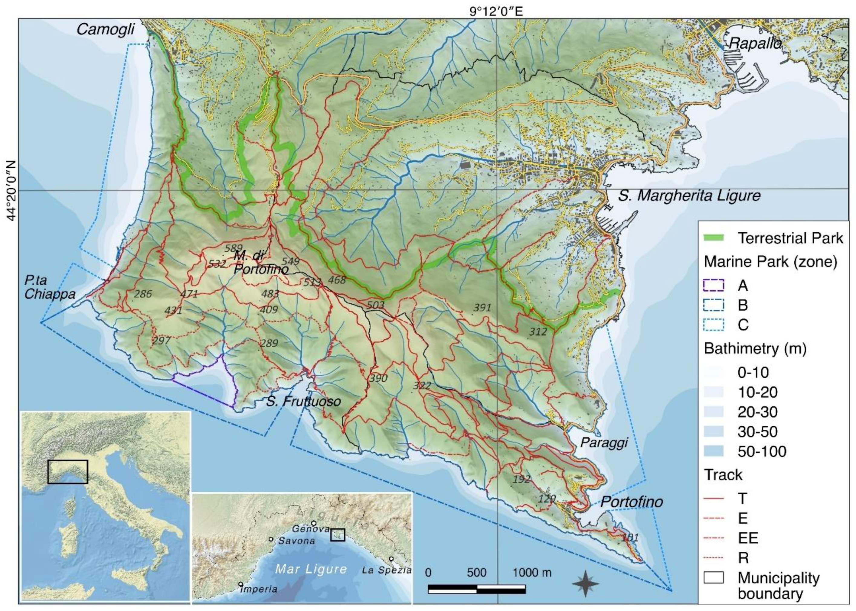
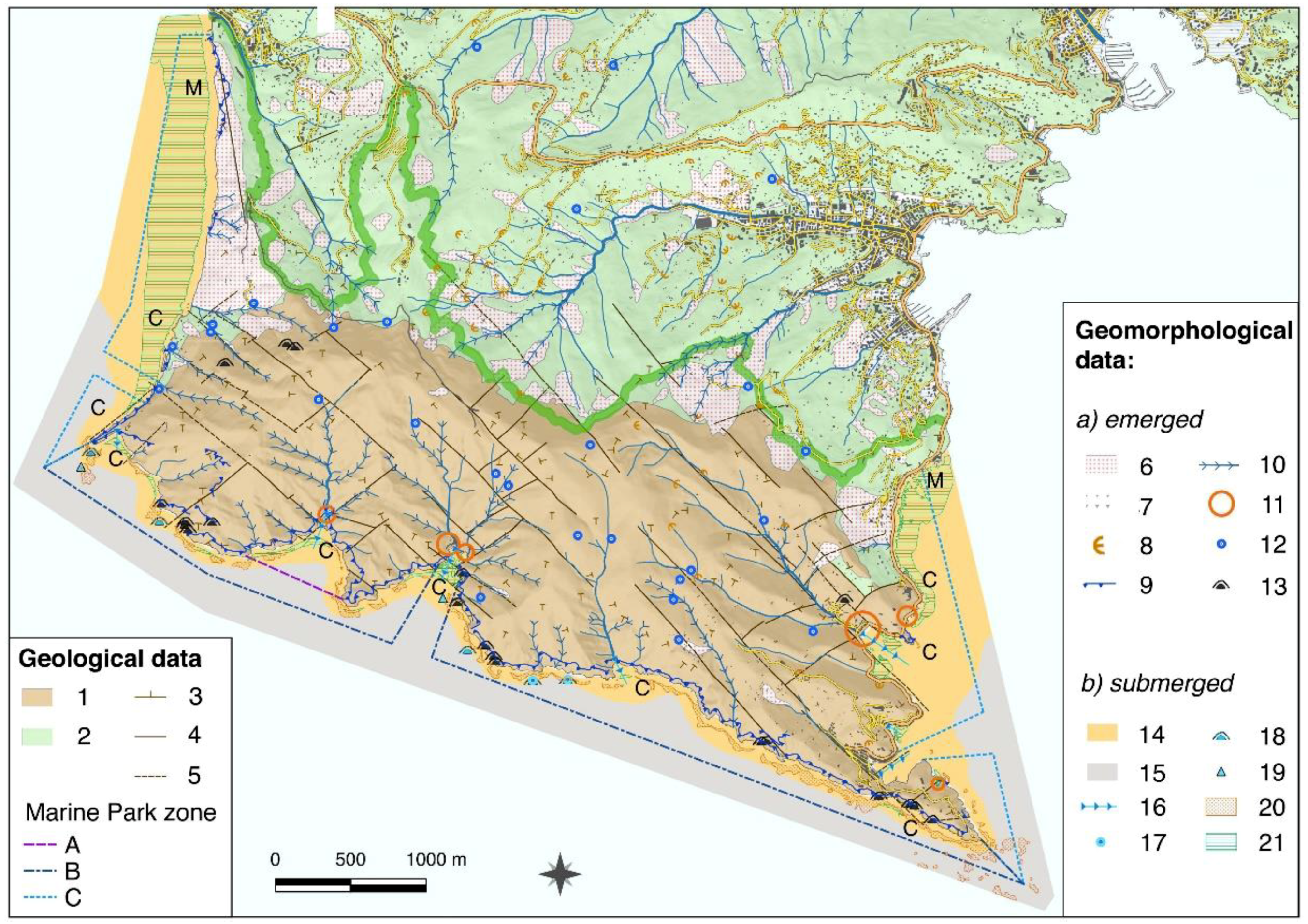
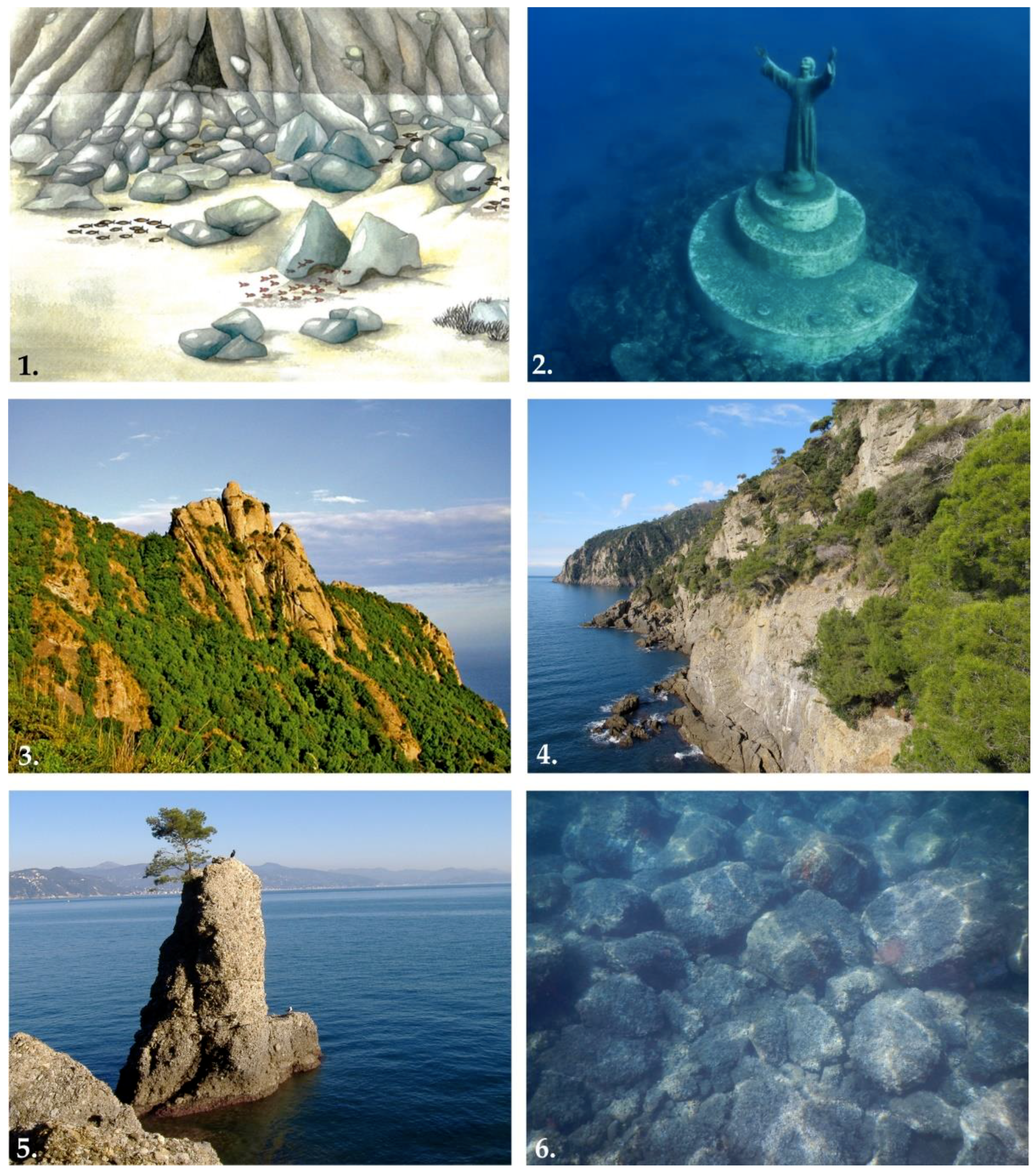
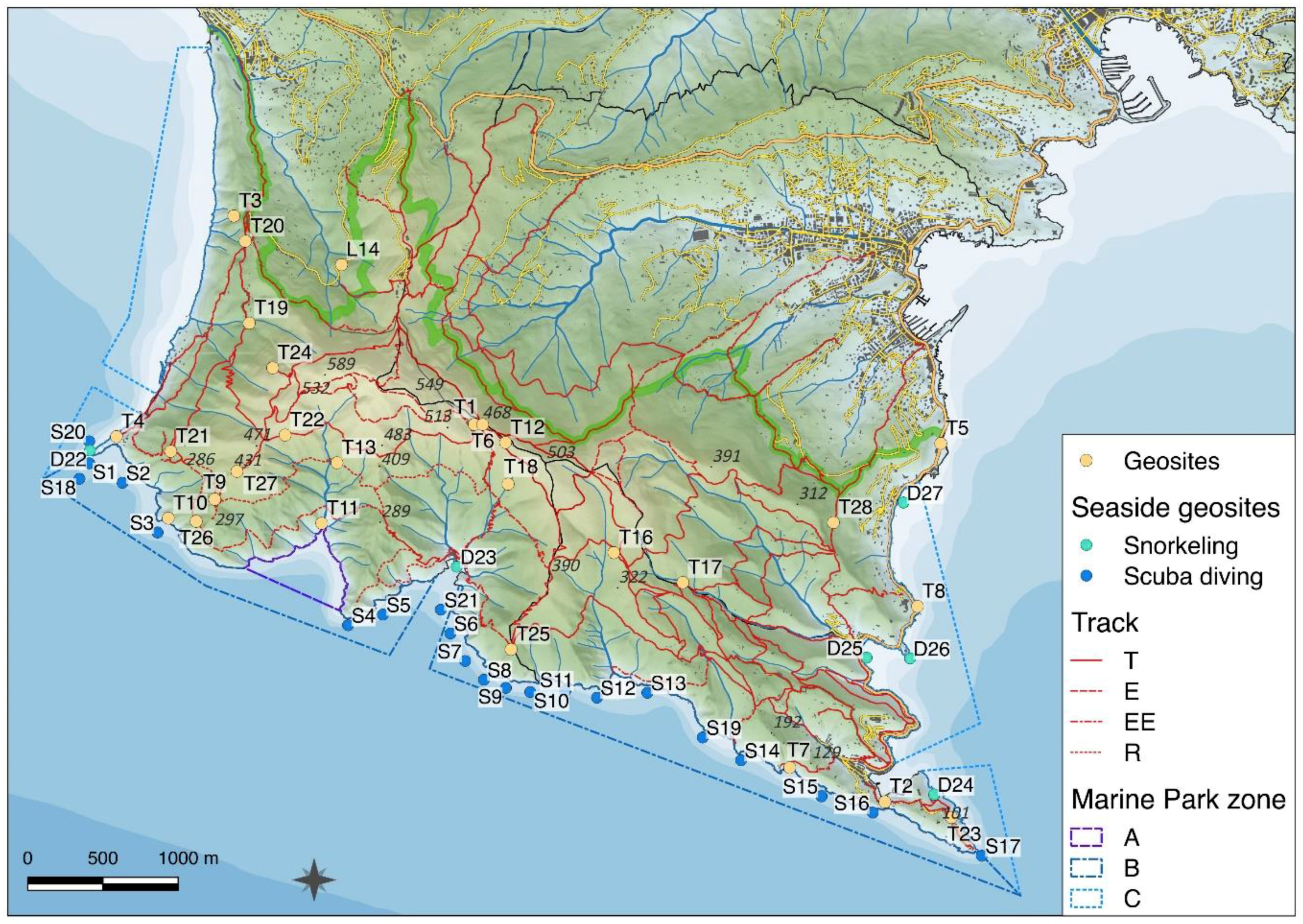
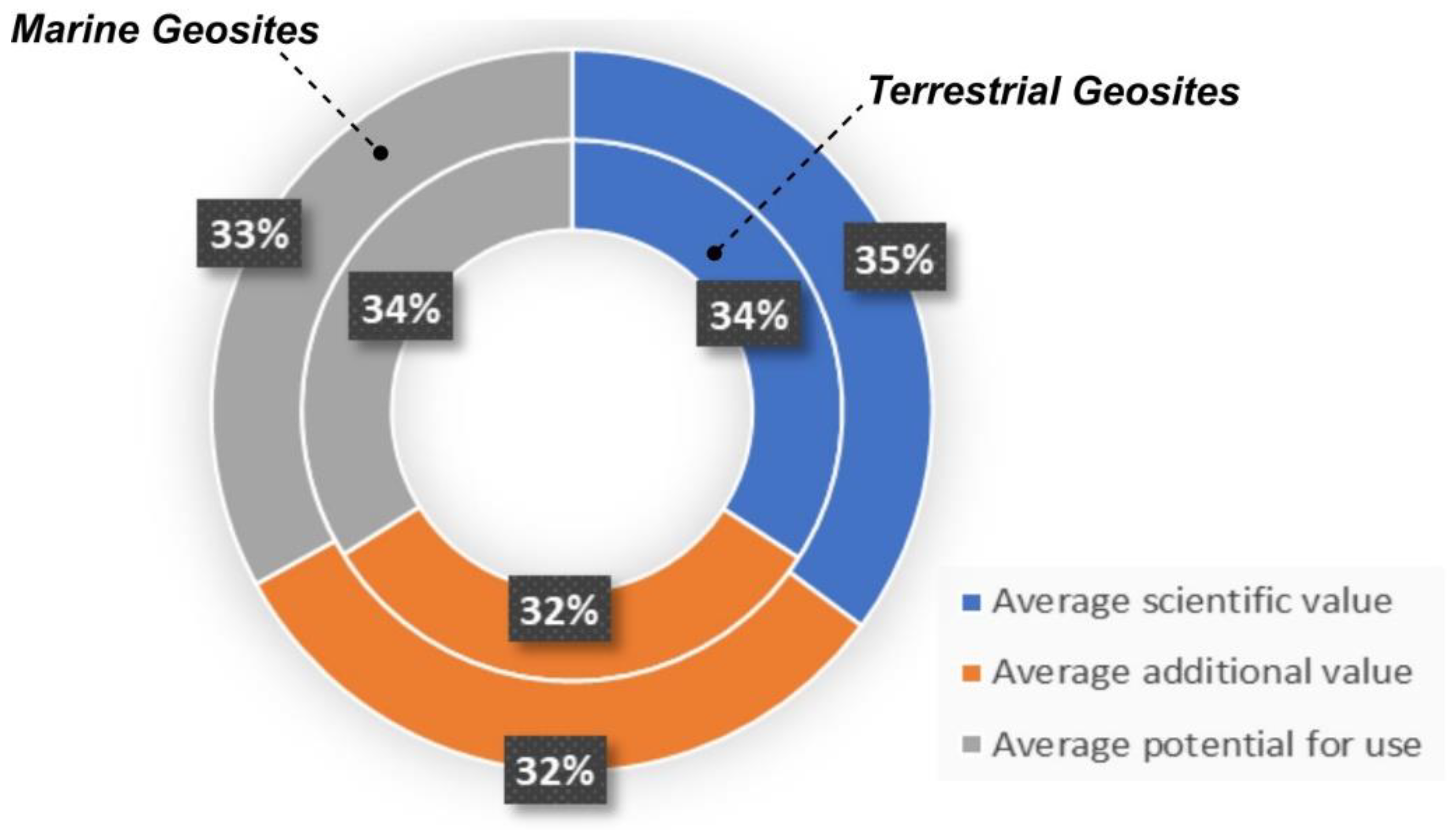
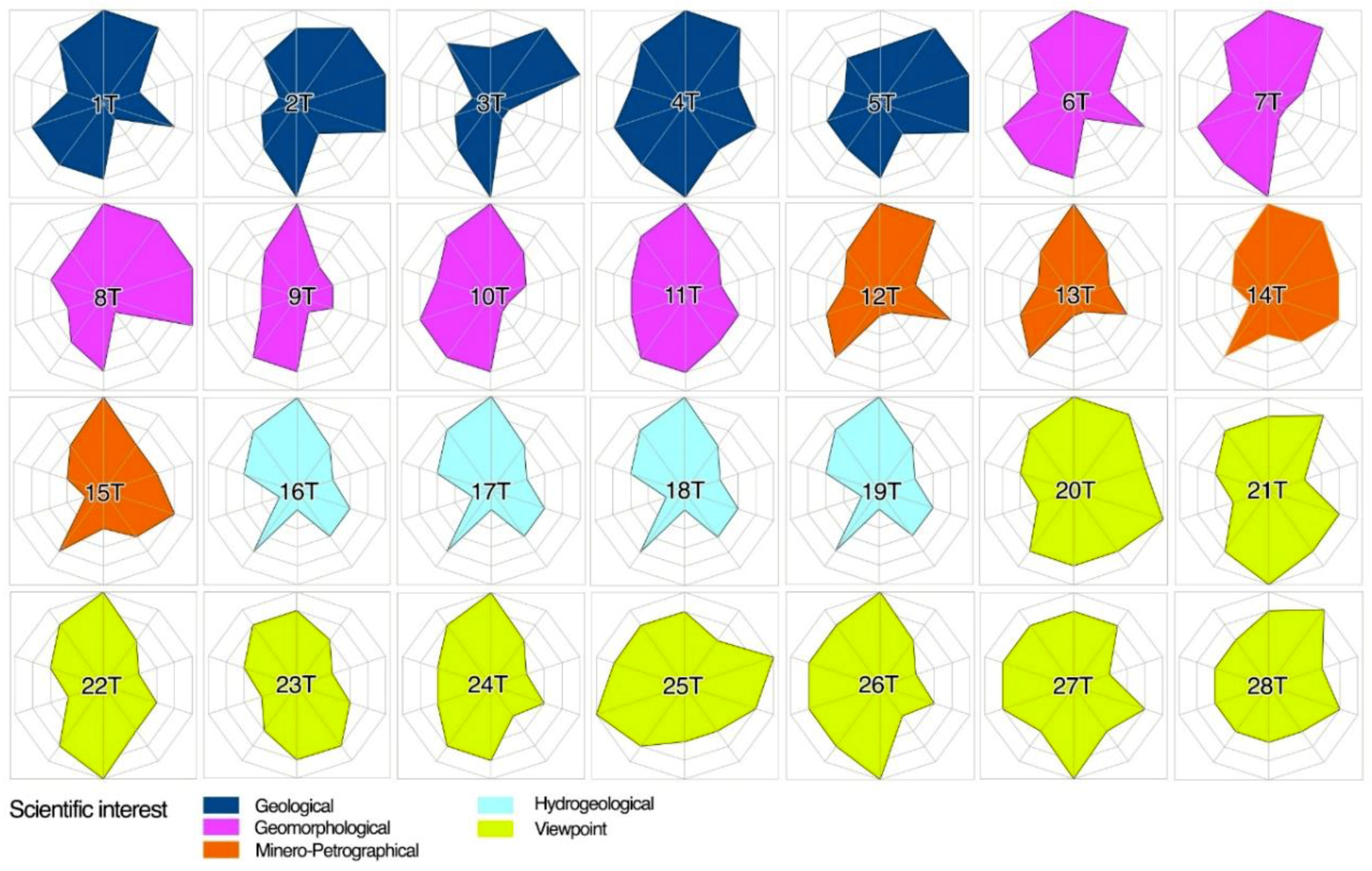
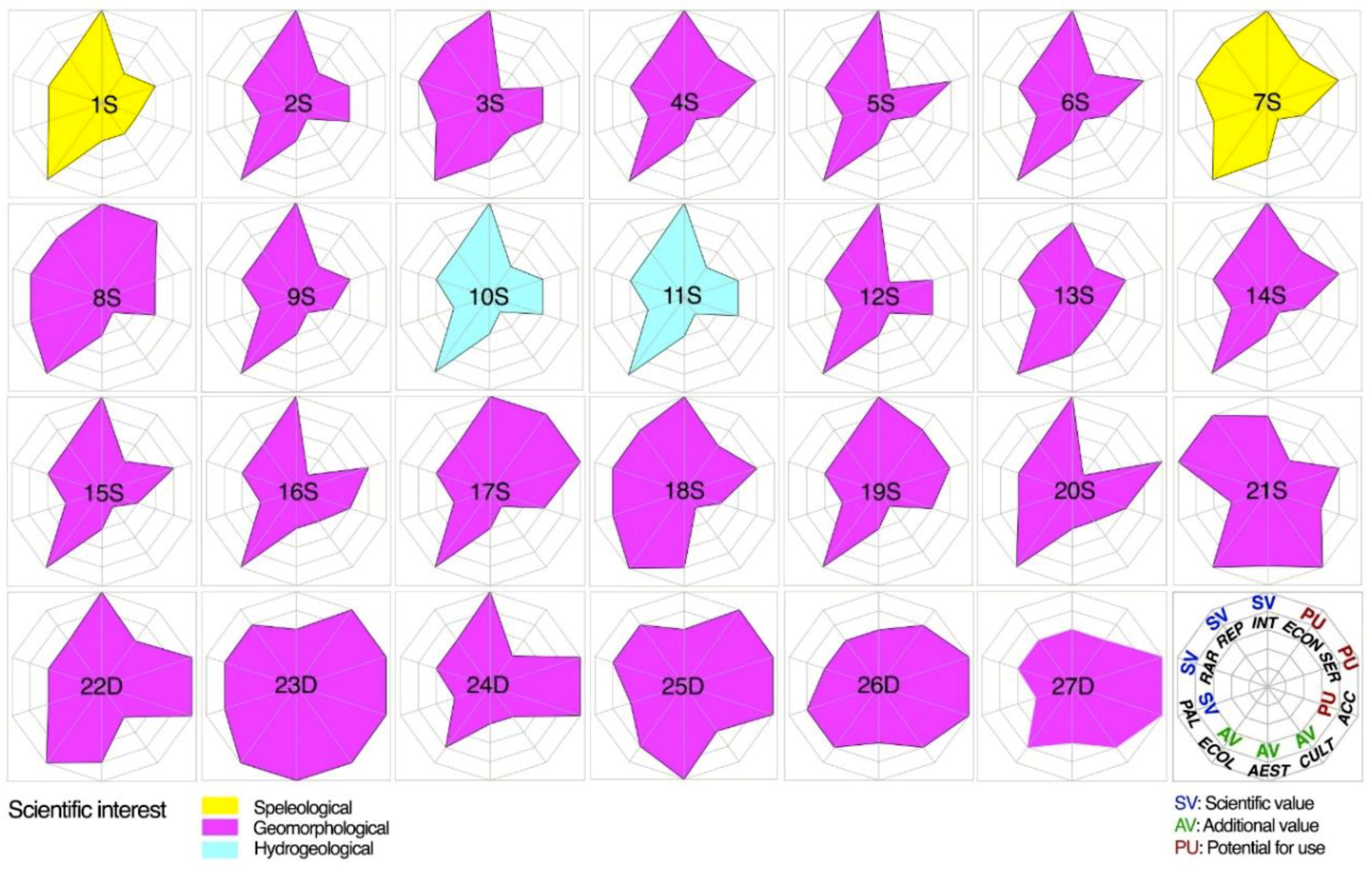
Table 1.
Terrestrial geosites.
| Nr | Name/Location | Scientific Interest | Features/Description |
|---|---|---|---|
| 1T | Pietre Strette | Geological | Conglomerate |
| 2T | St George Church | Geological | Conglomerate |
| 3T | St Rocco | Geological | Marly limestone |
| 4T | P.ta Chiappa | Geological | Conglomerate |
| 5T | P.ta Pedale | Geological | Marly limestone |
| 6T | Pietre Strette | Geomorphological | Boulders |
| 7T | Vitrale | Geomorphological | High cliffs |
| 8T | P.ta Cervara | Geomorphological | Sea stack |
| 9T | Mt. Campana | Geomorphological | Mass movement (lateral spread) |
| 10T | P.ta Budego | Geomorphological | High cliffs |
| 11T | Cala dell’Oro | Geomorphological | Inlet |
| 12T | Pietre Strette | Minero-Petrographical | Anagenite |
| 13T | Cala dell’Oro | Minero-Petrographical | Coal interlayers |
| 14T | St Rocco | Minero-Petrographical | Abandoned quarry |
| 15T | Rio Gentile | Minero-Petrographical | Abandoned quarry |
| 16T | Coppelli | Hydrogeological | Natural springs |
| 17T | Acquaviva | Hydrogeological | Natural springs |
| 18T | Caselle | Hydrogeological | Natural springs |
| 19T | Vegia | Hydrogeological | Natural springs |
| 20T | St Rocco | Viewpoints | Viewpoints |
| 21T | Batterie | Viewpoints | Viewpoints |
| 22T | Toca saddle | Viewpoints | Viewpoints |
| 23T | Castelletto | Viewpoints | Viewpoints |
| 24T | Rocca del Falco | Viewpoints | Viewpoints |
| 25T | Base O | Viewpoints | Viewpoints |
| 26T | Mt Campana | Viewpoints | Viewpoints |
| 27T | Semaforo Nuovo | Viewpoints | Viewpoints |
| 28T | Sotto le Gave | Viewpoints | Viewpoints |
Table 2.
Marine geosites (minimum and maximum depth are expressed in meters). The eighth column refers to the qualitative level of difficulty to reach a certain submerged geosite through scuba diving (source: [112]).
Table 2.
Marine geosites (minimum and maximum depth are expressed in meters). The eighth column refers to the qualitative level of difficulty to reach a certain submerged geosite through scuba diving (source: [112]).
| Nr | Name/Location | Scientific Interest | Features/Description | Protection Zone | Min Depth | Max Depth | Difficulty |
|---|---|---|---|---|---|---|---|
| 1S | Punta Chiappa di Levante | Speleological | Cave | B | 10 | 40 | high |
| 2S | Punta della Targhetta | Geomorphological | Submerged cliff | B | 8 | 20 | low |
| 3S | Grotta dellEremita | Geomorphological | Cave | B | 5 | 40 | low |
| 4S | Punta della Torretta | Geomorphological | Submerged cliff | B | 10 | 35 | high |
| 5S | Punta dell’Indiano | Geomorphological | Submerged cliff | B | 16 | 45 | high |
| 6S | Il Dragone | Geomorphological | Landslide blocks, cliff | B | 5 | 40 | high |
| 7S | La Colombara | Speleological | Cave | B | 10 | 30 | medium |
| 8S | Secca Gonzatti (Secca Carega) | Geomorphological | Submarine relief, shoal | B | 5 | 30 | medium |
| 9S | Targa Gonzatti | Geomorphological | Landslide blocks | B | 12 | 33 | high |
| 10S | Scoglio del Raviolo (Andrea Ghisotti) | Hydrogeological/Geomorphological | Cave and submarine spring | B | 10 | 35 | medium |
| 11S | Testa del Leone | Hydrogeological/Geomorphological | Cave and submarine spring | B | 8 | 35 | medium |
| 12S | Scoglio del Diamante | Geomorphological | Landslide blocks | B | 10 | 30 | low |
| 13S | Mohawk Deer | Geomorphological/Cultural | Landslide blocks and scarp | B | 10 | 40 | high |
| 14S | Punta Vessinaro | Geomorphological | Landslide blocks, submarine cliff | B | 10 | 35 | high |
| 15S | Casa del Sindaco - Vitrale | Geomorphological | Submarine cliff, landslide blocks | B | 20 | 40 | high |
| 16S | Chiesa di San Giorgio (La Liscia) | Geomorphological | Landslide blocks, cave | B | 10 | 40 | medium |
| 17S | Punta del Faro | Geomorphological | Landslide blocks, cliff | B | 16 | 40 | medium |
| 18S | Secca dell’Isuela | Geomorphological | Submarine relief | B | 14 | 40 | high |
| 19S | Punta dell’Altare | Geomorphological | Submarine cliff | B | 10 | 35 | medium |
| 20S | Punta Chiappa ponente | Geomorphological | Cliff, debris covered sea bottom | B | 5 | 25 | low |
| 21S | Cristo degli Abissi | Geomorphological/Cultural | Debris covered sea bottom, rocky blocks | B | 12 | 30 | low |
| 22D | Punta Chiappa | Geomorphological/Geological | Cliff, submarine scarp | B/C | 0 | 5 | low |
| 23D | Baia di San Fruttuoso | Geomorphological/Ecological | Seabed, submarine scarp, Posidonia meadows | B | 0 | 3 | low |
| 24D | Baia dell’Olivetta | Geomorphological | Boulders, submarine cliff | C | 0 | 3 | low |
| 25D | Baia di Paraggi | Geomorphological/Ecological | Seabed, submarine cliff, Posidonia meadows | C | 0 | 3 | low |
| 26D | Castello di Paraggi | Geomorphological | High cliff, rock fall boulders | C | 0 | 5 | low |
| 27D | Punta Cervara-Punta Pedale | Geomorphological/Geological | Landslide boulders, Posidonia meadows | C | 0 | 5 | low |
Table 3.
Sub-criteria used for the numerical assessment of geosite scientific value.
| Scientific Value | 1 | 2 | 3 | 4 | 5 |
|---|---|---|---|---|---|
| Integrity (INT): State of conservation of a landform | Poor conservation due to natural causes (after [43]) | Poor conservation due to inadequate management inadequate management | Damage may occur in some parts of landform but landscape integrity is preserved | Good conservation due to proper management | Good conservation due to natural conditions |
| Representativeness (REP): exemplarity with respect to a reference space [119] | No exemplarity (after [43]) | Poor example of process or landform | Fair example of process or landform | Good example of process or landform | Reference site (in scientific literature) for the description of process or landform |
| Rareness (RAR): | Very common | Rare at a local scale1 | Rare at a regional scale | Rare at a national scale | Rare at an international scale |
| rarity of the site with respect to a reference space [57] | |||||
| Paleogeographical model (PAL): Importance of a site in defining processes or environments characterizing the Earth history (modified after [43]) | No paleogeographic value (after [43]) | Scarce paleogeographic significance | Good representation of a paleoprocess | Good representation of a paleoenvironment | Good representation of a paleoprocess and a paleoenvironment |
1 Rare at the scale of Portofino Natural Protected area.
Table 4.
Sub-criteria used for the numerical assessment of geosite additional value.
| Additional Value | 1 | 2 | 3 | 4 | 5 | |
|---|---|---|---|---|---|---|
| Ecological value (ECOL): presence of ecotypes and level of the site protection for its natural features [128] | No ecotypes and no site protection | Presence of ecotypes without any protection | Presence of rare ecotypes and protection at a local level | Presence of rare ecotypes and protection at a regional level | Presence of rare ecotypes and protection at a national level | |
| Aesthetic value (AEST): [119] | Panoramic quality | Site not visible from any viewpoint | Site visible from one viewpoint | Site visible from more than one viewpoint | Site visible at 360° but within a close distance | Site visible from many viewpoints also at a great distance |
| Color diversity | No color diversity | Low color diversity | Moderate color diversity | High color diversity | Very high color diversity | |
| Vertical development | Same level as the surrounding ground | Slightly emerging from the surrounding ground | Moderately emerging from the surrounding ground | Significantly emerging from the surrounding ground | Imposing feature in the landscape | |
| Naturalness | Completely modified by human intervention | Strongly affected by human intervention but some natural features are still preserved | Moderately affected by human intervention but most of the natural features are preserved | Slightly affected by human intervention | No traces of human intervention | |
| Cultural value (CULT): [119] | Religious importance | No religious importance | Religious importance but no connection to geological and geomorphological features of the site | Religious importance with connection to geological or geomorphological features of the site | Local religious importance with connection to geological and geomorphological features of the site | National religious importance with connection to geological and geomorphological features of the site |
| Historical importance | No historical importance | Historical importance but no connection to geological and geomorphological features of the site | Historical importance with connection to geological or geomorphological features of the site | Local historical importance with both connections to geological and geomorphological features of the site | National historical importance with both connections to geological and geomorphological features of the site | |
| Artistic and/or literature importance | No artistic and literature importance | Artistic and/or literature importance but no connection to geological and geomorphological features of the site | Artistic and/or literature importance with connection to geological or geomorphological features of the site | Local artistic and/or literature importance with connections to both geological and geomorphological features of the site | National artistic and/or literature importance with connections to both geological and geomorphological features of the site | |
Table 5.
Sub-criteria used for the numerical assessment of geosite potential for use.
| Potential for Use Value | 1 | 2 | 3 | 4 | 5 | |
|---|---|---|---|---|---|---|
| Accessibility (ACC): level of accessibility | Land | No access | Accessible only by experts with specific technical skills (e.g., climbers, speleologists) | Accessible by experts but no specific technical skills are required | Accessible by people with normal movement capacity | Accessible by people with limited movement capacity |
| Sea [43] | No accessibility or only with indirect methods (e.g., ROV, submersible) | Accessible to expert professional divers or speleology divers | Accessible to 2nd level SCUBA divers (max depth 40 m) | Accessible to 1st level SCUBA divers (max depth 18 m) | Accessible to snorkeling | |
| Services | Land: presence of equipment and support services in the nearby [119] | No services | Support services within a walkable distance but subject to seasonal availability | Equipment available but subject to seasonal availability | Equipment and services in the near proximity of the site subject to seasonal availability | Equipment and support services in the near proximity of the site, available 7/24 all year round |
| (SER) | Sea: distance from the nearest boarding dock [58] | distance from the boarding dock > 10 km | distance from the boarding dock between 10 and 7 km | distance from the boarding dock between 7 and 5 km | distance from the boarding dock between 5 and 2 km | distance from the boarding dock < 2 km |
| Economic potential (ECON): number of visitors per year | land | Visitors < 5000 | 5000 < visitors ≤ 20,000 | 20,000 < visitors ≤ | 50,000 < visitors ≤ | visitors > 70,000 |
| 50,000 | 70,000 | |||||
| sea | Visitors ≤ 100 | 100 < visitors ≤ 400 | 400 < visitors ≤ 700 | 700 < visitors ≤ 1000 | Visitors > | |
| 1000 |
© 2019 by the authors. Licensee MDPI, Basel, Switzerland. This article is an open access article distributed under the terms and conditions of the Creative Commons Attribution (CC BY) license (http://creativecommons.org/licenses/by/4.0/).
Share and Cite
MDPI and ACS Style
Coratza, P.; Vandelli, V.; Fiorentini, L.; Paliaga, G.; Faccini, F. Bridging Terrestrial and Marine Geoheritage: Assessing Geosites in Portofino Natural Park (Italy). Water 2019, 11, 2112. https://doi.org/10.3390/w11102112
AMA Style
Coratza P, Vandelli V, Fiorentini L, Paliaga G, Faccini F. Bridging Terrestrial and Marine Geoheritage: Assessing Geosites in Portofino Natural Park (Italy). Water. 2019; 11(10):2112. https://doi.org/10.3390/w11102112
Chicago/Turabian StyleCoratza, Paola, Vittoria Vandelli, Lara Fiorentini, Guido Paliaga, and Francesco Faccini. 2019. "Bridging Terrestrial and Marine Geoheritage: Assessing Geosites in Portofino Natural Park (Italy)" Water 11, no. 10: 2112. https://doi.org/10.3390/w11102112
Note that from the first issue of 2016, this journal uses article numbers instead of page numbers. See further details here.