What architects need to know about hazard and climate risk
Published: April 17, 2019 | Updated: October 23, 2021
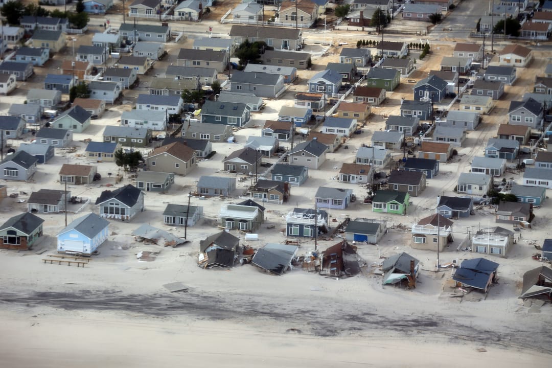
Hurricane Sandy devastated communities throughout coastal new jersey in 2012. By taking advantage of state, local, and federal resources, architects can contribute to mitigating climate and hazard risk in the built environment.
Getting a handle on climate and hazard risk will help you help your clients. How can you build the most resilient, adaptive projects?
More than 40 billion-dollar natural disasters have impacted the U.S. over the last three years. With increasing frequency and intensity, disasters are devastating the built environment in unprecedented ways. Many clients don’t fully understand the risk their buildings face and need more information to adequately address resilience and adaptation. To convince clients of the value hazard mitigation and climate adaptation bring to a project, architects must first do their homework by analyzing the short-term and long-term risks over the building service life.
Clients may perceive hazard mitigation and climate adaptation strategies as unnecessary added costs. It is the architect’s purview to discuss project-specific risks with the client, so they can make informed design and development decisions. Such information can be leveraged and expanded to provide an additional new professional service.
Many projects—from new construction to existing buildings to development—benefit from a vulnerability assessment. A building vulnerability assessment looks at the expected building performance level given physical and environmental vulnerabilities. An initial step of a vulnerability assessment is to understand risk by conducting a hazard and climate assessment. The process involves identifying which hazards could impact the area of study, identifying the intensity of each hazard, identifying the frequency and probability of occurrence, the area of impact, and the duration of impact. Information gleaned from the assessment tells us what risks may face the project and empowers the architect to extrapolate the potential impact on building safety, performance, and function.
While recommended as a regular practice for all projects, an assessment will particularly benefit building owners, businesses, and other entities who cannot be out of commission for more than three days. Building types that fall within those parameters may include critical and community facilities as well as corporations or facilities that serve vulnerable populations. When possible, a vulnerability assessment should be conducted prior to the design phase as it may actually help inform site selection and program requirements.
Where to start: identifying hazard and climate risk
To understand the impact of potential hazard and climate events, begin by identifying the projected building service life. It’s important to realize that risk is not static—it will evolve over time due to changing climatic conditions. Whether it be 30, 50, or 100 years, projecting the building service life will help you identify the short-term and long-term risks. Given that the average service life of a building is 80 years, buildings designed this year and built next year will live to see the climate projections of 2100. Identify the hazard types that your project may face along with the frequency and probability of occurrence, duration of impact, and potential for damage. Use historical data as well as climate change projections that align with the building’s projected service life.
A number of resources can provide useful hazard and climate risk information. State, local, and tribal plans for hazard mitigation, climate change adaptation, and disaster recovery provide risk analysis as well as planned community-scale actions that may inform design decisions. Hazard-specific maps, models, and data are also available. Architects may find this hazard data in city GIS maps and can work with a consultant to verify specific risks. Some states and municipalities also offer digital tools for viewing hazard and climate risks.
Additionally, FEMA’s online database can provide a history of disasters for the area in question, while climate projection tools such as NOAA’s Sea Level Rise Viewer and the U.S Climate Resilience Toolkit’s Climate Explorer provide maps that anticipate future environmental changes that may increase hazard risk. Climate projection tools and maps like these are critical to understanding the volatile environmental conditions a building will be exposed to during its service life.
By analyzing and communicating the exposure to shocks and stresses over the duration of the building service life, architects can raise client awareness of risk and the value of hazard mitigation and climate adaptation in reducing a building’s potential for damage and disruption.
Dig deeper: what are hazard mitigation and climate adaptation plans really telling you?
Hazard mitigation plans typically include a risk assessment that describes the hazards for the area and may include future risk due to climate change. Plans sometimes list and rank hazards according to the threat they pose—a function of the probable magnitude and likely occurrence of the hazard and the vulnerability of the system. Local and county plans have more detailed information than state plans, which in turn have more specific information than federal resources.
Similar to the way in which hazard mitigation plans include hazard type, probable magnitude, and probability of occurrence, climate adaptation plans include localized climate change projections over time. They tell us how projections for temperature and precipitation may increase hazard risk. When such projections are not available in a state or local climate adaptation plan, use the 4th National Climate Assessment to understand regional impacts of climate change.
While developing designs and project plans, remember that site specific conditions may alter the risk identified in the overall community plan and all sites are vulnerable to multiple hazards. Keep in mind that resilience is a design challenge. No single resource will provide everything you may need, but by using a wide range of available plans, maps, and data in tandem, you’ll be able to design more effectively and understand risk better.
Know the limitations of your data
While architects and their design teams may traditionally refer to the local building code for climate and hazard information, the most current edition of the building code often has less detail than other data sources. Keep in mind that building codes represent historical data—precipitation and temperature ranges in the building code climate zones references data from 1961-1990.
It’s always important to note the age and source of the data referenced in plans and hazard maps. Some sources rely on limited data and may not have not been remapped for decades. FEMA Flood Insurance Rate Maps (FIRMs), for example, do not account for heavy rainfall, sea level rise, or tidal flooding and include limited riverine flooding and storm surge data. When Superstorm Sandy hit New York in 2012, the FEMA FIRMs for the area were 30 years old; drastically underrepresenting the flood risk. To supplement maps—particularly FIRMs, which are drawn for the purposes of delineating insurance risk premiums—an additional site-specific study may be needed to create a more accurate picture of vulnerability.
Fortunately, the limitations of current hazard maps are starting to be recognized and in some cases, the data utilized in them is improving. A new policy will enable FEMA to use private-sector data to calculate the real flood threat for homes when drawing future FIRMs. When limited by readily available information, architects also benefit from engaging other experts such as climatologists, environmental scientists, and engineers to gain and assess site and building data.
Case study: how understanding risk made a difference for one client
When North America’s largest roofing manufacturer, GAF, was planning its new headquarters in Parsippany, New Jersey, the company learned from the power outages, flooding, and high winds of Hurricane Sandy and Hurricane Irene. They prioritized continuous operations, so they could continue to support their 29 manufacturing plants and customers during a hazard event. The new headquarters was completed by NELSON and was ultimately named the first building to earn a USGBC resilience pilot credit.
After being unable to access their Wayne, NJ headquarters for a number of days following Sandy because of flooded roads, the GAF team and their collaborators prioritized site access during their search process. To understand their risk, GAF’s design team conducted a hazard assessment which identified severe storms, winter storms, and flooding as the most significant hazard event threats to the site. The assessment included floodway mapping of roads for all candidate sites so the team could comprehend the potential impact of these hazards. During this process, they found that the primary access road to one of the top three candidate sites was located in the floodplain. Thus, the hazard assessment led GAF to select an alternative, lower risk site location.
Hurricane Sandy and Hurricane Irene brought gusts of 115-120mph to the eastern seaboard. With high-winds as a major risk, GAF made the design of their headquarters’ roof a priority, leveraging their in-house roofing science expertise to minimize potential damage and business downtime. The roofing system engineered by GAF’s Building and Roofing Science Division exceeded local codes (90mph) and meets FEMA Wind Zone II velocities (160 mph). Recognizing power outage as a common secondary hazard and taking stock of the costs associated with disruptions caused by the 2011 and 2012 hurricanes, GAF also included a “command center” in the programming requirements of their new headquarters that included a dedicated back-up power generator for continuous operations. These risk-informed design decisions create a more resilient building; benefiting GAF, its employees, and its customers in the event of another major disaster.
For more information about identifying hazard and climate risk, vulnerability assessments, and associated resources explore AIA’s Resilience and Adaptation Online Certificate Series.
Image credits

Getty


