Remnants Of Ida Bring Tornado, Flash Flooding Threats To Philadelphia Region
PHILADELPHIA (CBS) -- Significant flooding is likely as remnants of Hurricane Ida move over the Delaware and Lehigh Valleys on Wednesday and into early Thursday. A flash flood watch will be in effect for the entire region from 8 a.m. Wednesday until 2 p.m. Thursday as Ida impacts the region.
A flash flooding warning is in effect for large portions of the area -- including Philadelphia, the Pennsylvania suburbs, New Jersey suburbs, and Delaware -- until 11:30 p.m.
A tornado watch has been issued for parts of Pennsylvania, New Jersey and Delaware until 10 p.m.
Numerous flash flooding events are likely. Many streams, creeks and rivers will also flood. The Schuylkill in Philly is forecast to crest just shy of Moderate Flood Stage Thursday afternoon. At this level, Route 1 off ramp to Ridge Avenue is flooded and closed. MLK Drive is flooded and closed between Greenland Drive and Montgomery Drive, and Main Street in Manayunk floods around Shurs Lane.
Soil moisture conditions across portions of the area are in the 90%+ percentile range due to recent heavy rains and thus this will exacerbate the already high potential for flooding during this event. Widespread 2-5"+ of rainfall is expected across PA. Extremely excessive totals over 6" are possible in the Poconos and Lehigh Valley. NJ and most of DE look to be in the 1-3" rainfall range, with locally higher amounts.
Rain looks to overspread the area, mainly N & W, overnight. Steady and periods of heavy rain is likely to persist through the duration of the event in the Poconos, Lehigh Valley, and Berks Co. In Philly proper, South Jersey and much of DE, the steady rain may not get going until late Thursday. Steady and heavy to torrential rain will affect the entire area tomorrow night. The good news is the latest runs of both the Euro and GFS have Ida out of here much more quickly, possibly as early as 6 a.m. Thursday.
Pennsylvania Gov. Tom Wolf signed an emergency proclamation Tuesday ahead of Ida's potential flooding.
"This dangerous storm continues to have devastating impacts across the South and as it heads toward Pennsylvania, we are expecting significant rainfall across the state. This proclamation will allow for our emergency preparedness teams to provide any support needed throughout the storm and its aftermath," Gov. Wolf said. "I urge Pennsylvanians to monitor local weather and traffic conditions before making any plans and prepare for potential flooding."
The heaviest rain looks to affect the area Wednesday night into Thursday morning -- with the highest totals across Pennsylvania.
Ida is expected to exit the area by late Thursday afternoon and behind it will be the nicest weather the region has seen in weeks.
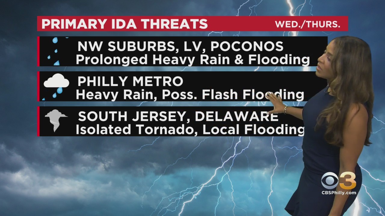
LOCAL IDA IMPACTS
- Timing: Wednesday morning through Thursday afternoon
- Threats: Heavy rain, flash, urban and river flooding, severe thunderstorms, isolated tornadoes
The latest data on rainfall totals are concerning with outputs of over six inches in our northwest suburbs, the Lehigh Valley and Poconos, where steady and heavy rain looks to begin by midday on Wednesday, whereas in Philadelphia, South Jersey and much of Delaware.
The rain will not begin until Wednesday evening or night. At present, Center City looks to be in the 2-3" rainfall accumulation range, with 3-5" for most of Pennsylvania and 1-2+ for New Jersey and Delaware with of course locally higher amounts.
By midday Thursday, most of Ida's rain will be offshore, though scattered showers may persist into the afternoon.
Also, as we experienced with Elsa and Henri, the remnants of tropical systems can pose the threat for tornadoes. These tornadoes almost exclusively occur on the easter side of the storm track. At present, South Jersey and Delaware would be in this sector.
However, a subtle shift in track to the west would introduce Philadelphia and nearby suburbs to this potential.
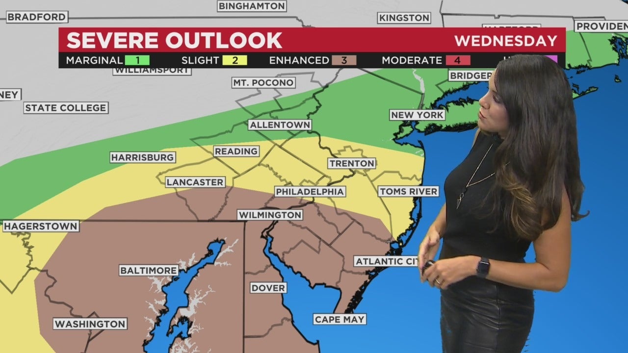
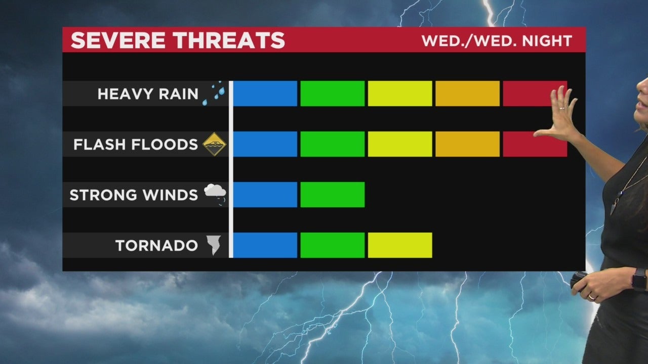
The tornado threat is elevated in our area. The SPC now has the southern half of the area in an Enhanced Risk of severe weather.
The threat looks to be most pronounced from late afternoon into the first part of Wednesday night.
In addition to the tornado risk, severe thunderstorms may produce damaging wind gusts leading to the possibility of downed trees and wires, particularly in conduction with the oversaturated soil.
Additionally, the National Weather Service in Mt. Holly at 35 tornado warnings this year, is one issuance away from setting a record. The old record was set just last year.
TROPICS
Julian is dead. Kate has formed but will have a short life span. A tropical wave set to move off the coast of Africa has a 90% chance of development in the next 5 days. This may be one to watch. The next name is Larry.
Download the CBS Philly Weather App for the most up-to-date weather forecast. The app is free on Apple and Android devices.