
Beyond Streamflow: Call for a National Data Repository of Streamflow Presence for Streams and Rivers in the United States


 , , , , , , , and
Abstract
:1. Introduction
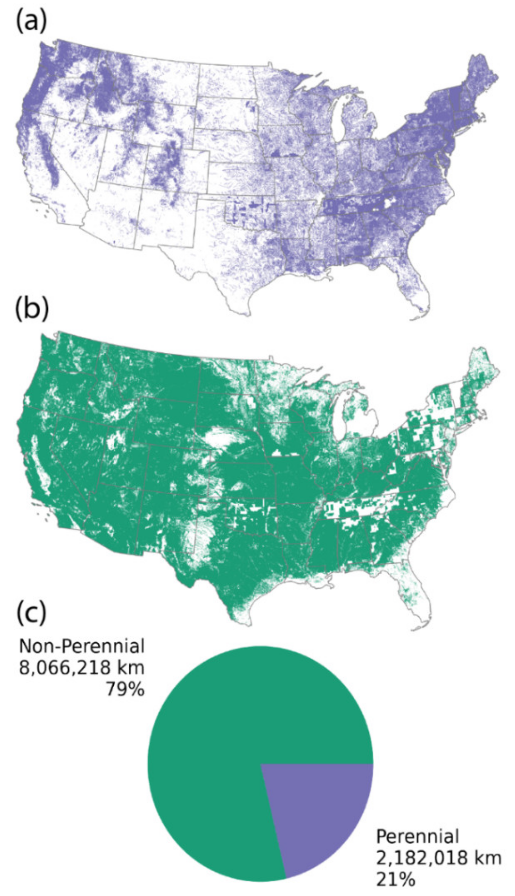
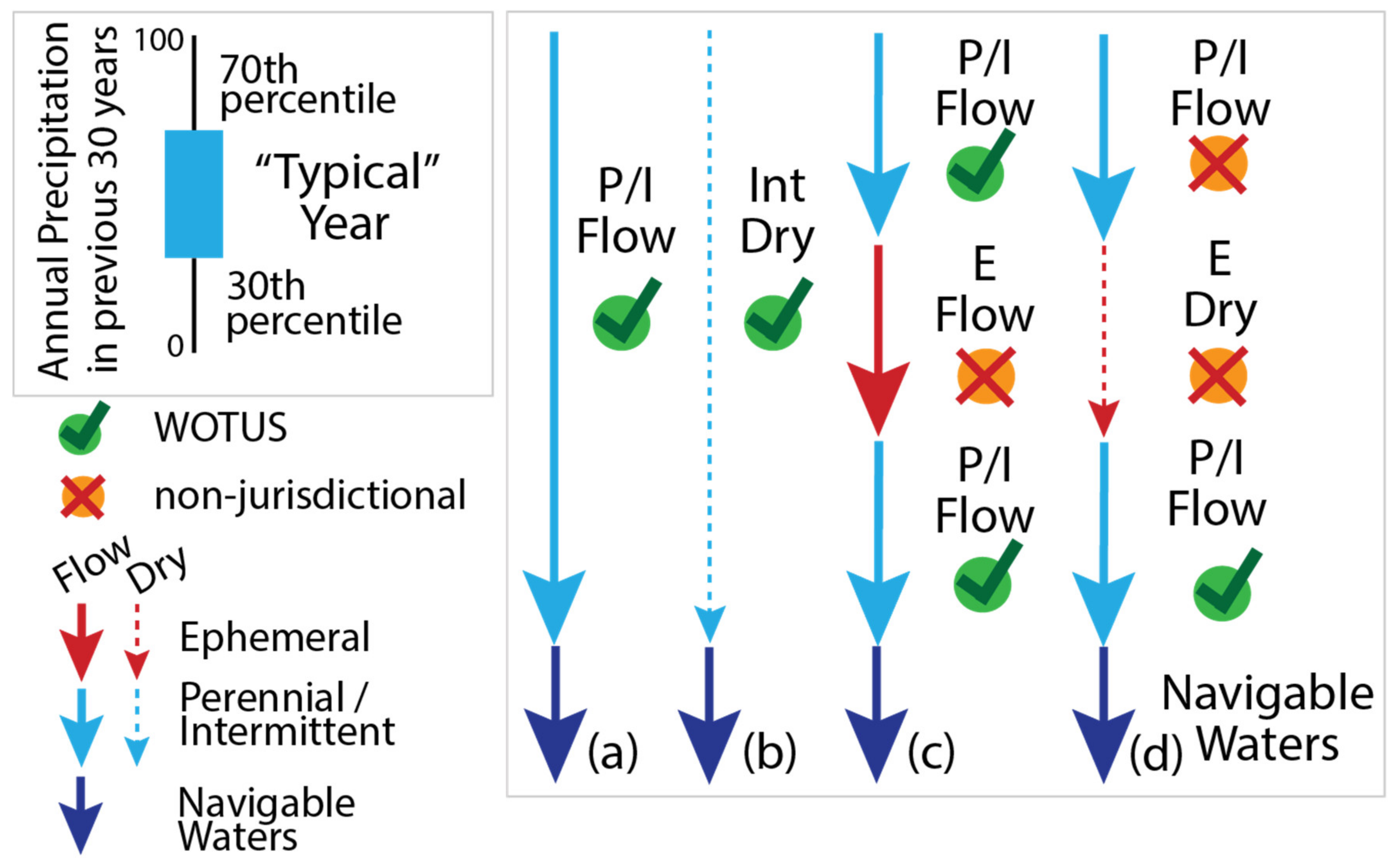
2. Background
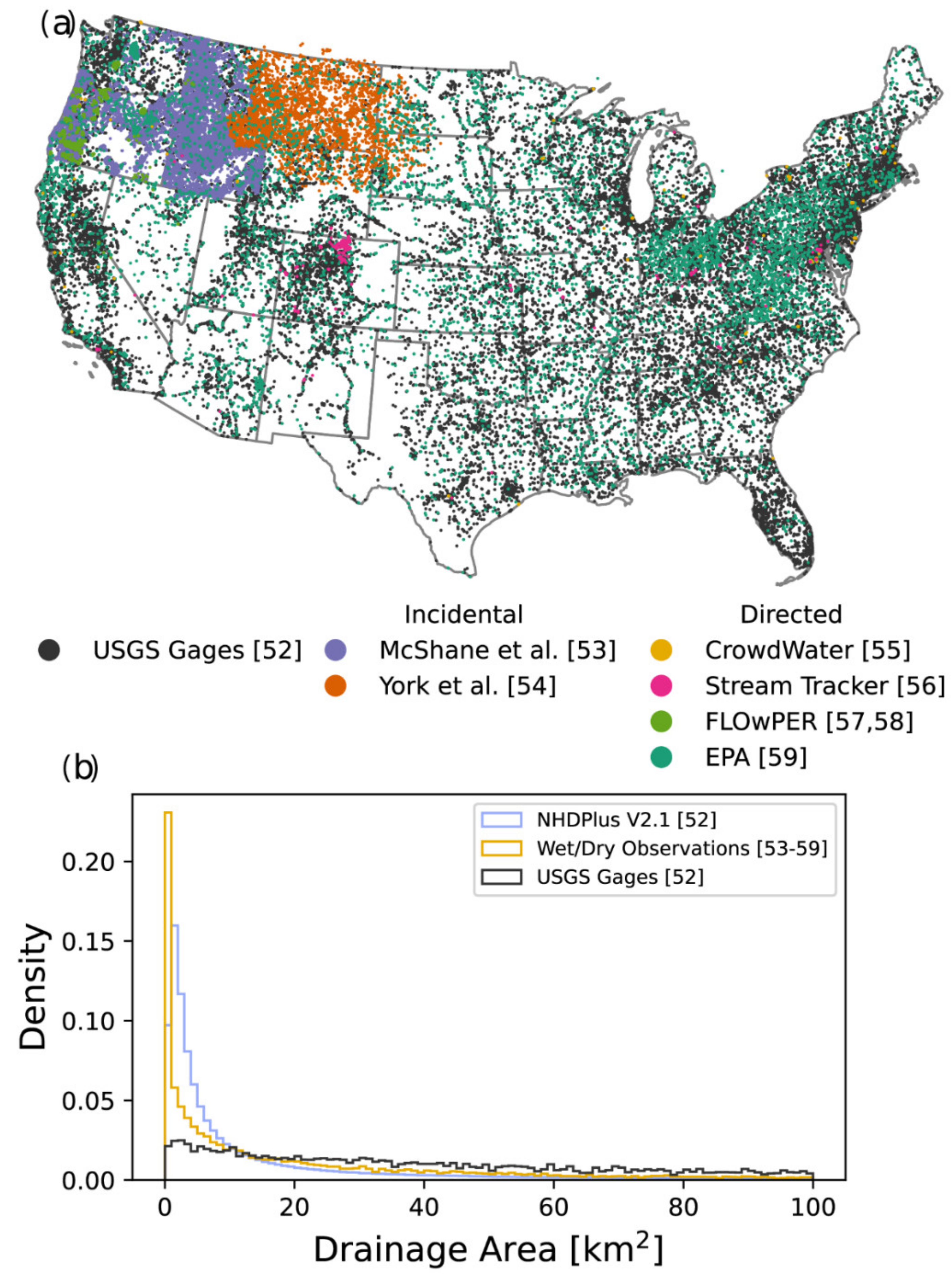
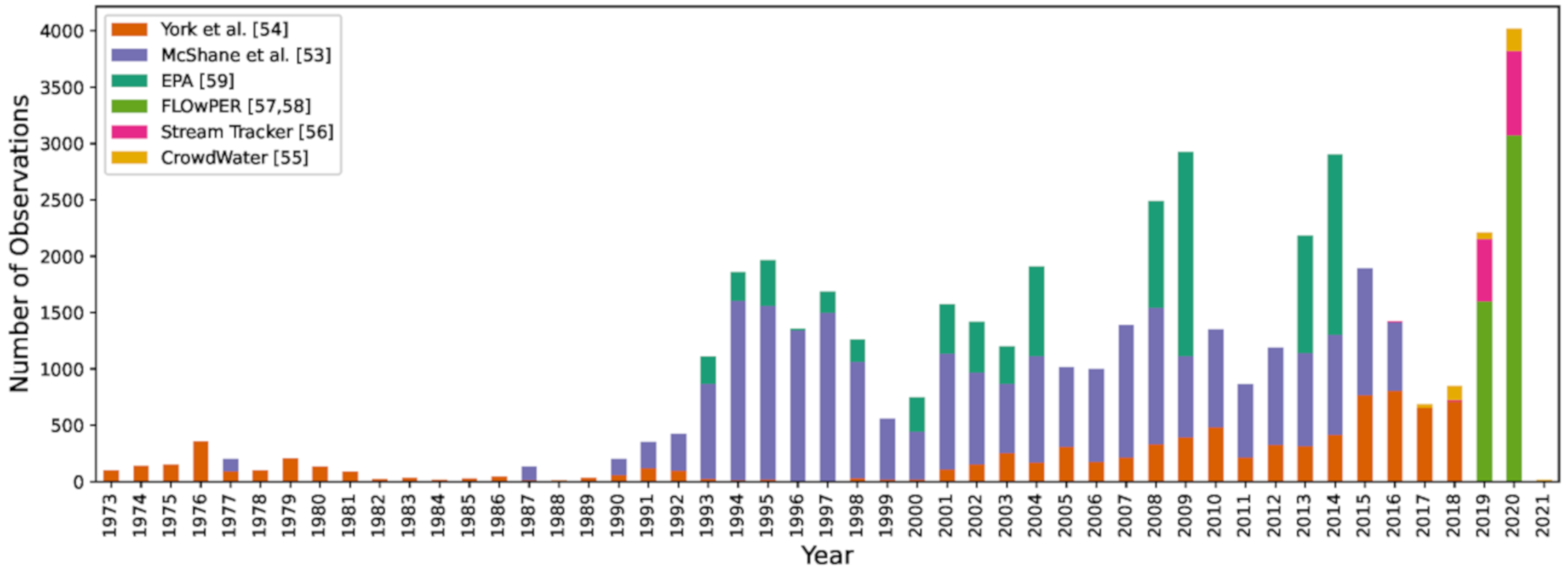
3. Surveys That Provide Incidental Information on Streamflow Permanence
4. Surveys Designed Specifically for Identifying Surface Water Presence and Characterizing Streamflow Permanence
5. Applications of Streamflow Presence Data
6. Challenges with Compiling Water Presence Observations
6.1. Consistency of Terminology and Methods across Sampling Programs
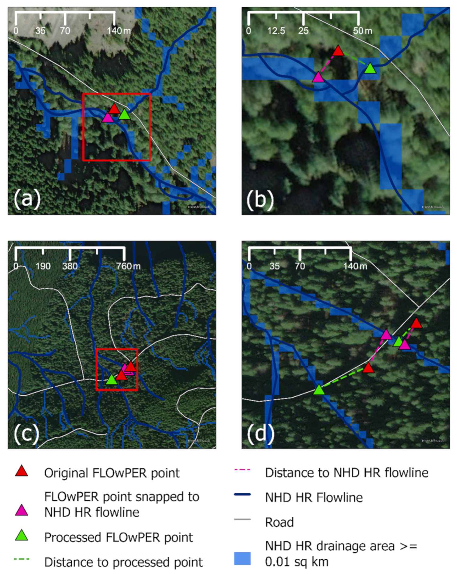
6.2. Accuracy of Geographic Information and Association with a Hydrologic Network
6.3. Timing and Temporal Resolution
6.4. Observation and Sampling Errors
7. Next Steps
Author Contributions
Funding
Data Availability Statement
Acknowledgments
Conflicts of Interest
References
- Poff, N.L.; Allan, J.D.; Bain, M.B.; Karr, J.R.; Prestegaard, K.L.; Richter, B.D.; Sparks, R.E.; Stromberg, J.C. The natural flow regime. BioScience 1997, 47, 769–784. [Google Scholar] [CrossRef]
- Arthington, A.H. Environmental Flows: Saving Rivers in the Third Millennium; Univ. of California Press: Auckland, CA, USA, 2012; Volume 4. [Google Scholar]
- Miller, M.P.; Clark, B.R.; Eberts, S.M.; Lambert, P.M.; Toccalino, P. Water Priorities for the Nation—US Geological Survey Integrated Water Availability Assessments; United States Geological Survey: Reston, VA, USA, 2020. [Google Scholar]
- Leigh, C.; Boulton, A.J.; Courtwright, J.L.; Fritz, K.; May, C.L.; Walker, R.H.; Datry, T. Ecological research and management of intermittent rivers: An historical review and future directions. Freshw. Biol. 2016, 61, 1181–1199. [Google Scholar] [CrossRef]
- Datry, T.; Bonada, N.; Boulton, A. Intermittent Rivers and Ephemeral Streams: Ecology and Management; Academic Press-Elsevier: Cambridge, MA, USA, 2017; Volume 25, p. 102. [Google Scholar]
- Busch, M.H.; Costigan, K.H.; Fritz, K.M.; Datry, T.; Krabbenhoft, C.A.; Hammond, J.C.; Zimmer, M.; Olden, J.D.; Burrows, R.M.; Dodds, W.K. What’s in a Name? Patterns, Trends, and Suggestions for Defining Non-Perennial Rivers and Streams. Water 2020, 12, 1980. [Google Scholar] [CrossRef]
- Jaeger, K.; Sando, R.; McShane, R.; Dunham, J.; Hockman-Wert, D.; Kaiser, K.; Hafen, K.; Risley, J.; Blasch, K. Probability of Streamflow Permanence Model (PROSPER): A spatially continuous model of annual streamflow permanence throughout the Pacific Northwest. J. Hydrol. X 2019, 2, 100005. [Google Scholar] [CrossRef]
- Zimmer, M.A.; Kaiser, K.E.; Blaszczak, J.R.; Zipper, S.C.; Hammond, J.C.; Fritz, K.M.; Costigan, K.H.; Hosen, J.; Godsey, S.E.; Allen, G.H. Zero or not? Causes and consequences of zero-flow stream gage readings. Wiley Interdiscip. Rev. Water 2020, 7, e1436. [Google Scholar]
- USEPA and USACE. The Navigable Waters Protection Rule: Definition of “Waters of the United States"; In 85 Fed. Reg. 22250 (A2020). 2020. Available online: https://www.federalregister.gov/documents/2020/04/21/2020-02500/the-navigable-waters-protection-rule-definition-of-waters-of-the-united-states (accessed on 4 June 2021).
- Datry, T.; Larned, S.T.; Tockner, K. Intermittent rivers: A challenge for freshwater ecology. BioScience 2014, 64, 229–235. [Google Scholar] [CrossRef] [Green Version]
- Messager, M.L.; Lehner, B.; Cockburn, C.; Lamouroux, N.; Pella, H.; Snelder, T.; Tockner, K.; Trautmann, T.; Watt, C.; Datry, T. Global prevalence of non-perennial rivers and streams. Nature 2021, in press. [Google Scholar]
- Deweber, J.T.; Tsang, Y.P.; Krueger, D.M.; Whittier, J.B.; Wagner, T.; Infante, D.M.; Whelan, G. Importance of understanding landscape biases in USGS gage locations: Implications and solutions for managers. Fisheries 2014, 39, 155–163. [Google Scholar] [CrossRef]
- Granato, G.E.; Ries, K.G., III; Steeves, P.A. Compilation of Streamflow Statistics Calculated from Daily Mean Streamflow Data Collected During Water Years 1901–2015 for Selected US Geological Survey Streamgages; Open File Report; United States Geological Survey: Reston, VA, USA, 2017; p. 17. [Google Scholar]
- Kovach, R.P.; Dunham, J.B.; Al-Chokhachy, R.; Snyder, C.D.; Letcher, B.H.; Young, J.A.; Beever, E.A.; Pederson, G.T.; Lynch, A.J.; Hitt, N.P.; et al. An Integrated Framework for Ecological Drought across Riverscapes of North. America. BioScience 2019, 69, 418–431. [Google Scholar] [CrossRef] [Green Version]
- Hammond, J.C.; Zimmer, M.; Shanafield, M.; Kaiser, K.; Godsey, S.E.; Mims, M.C.; Zipper, S.C.; Burrows, R.M.; Kampf, S.K.; Dodds, W. Spatial patterns and drivers of non-perennial flow regimes in the contiguous United States. Geophys. Res. Lett. 2021, 48, e90794. [Google Scholar] [CrossRef]
- Ward, A.S.; Wondzell, S.M.; Schmadel, N.M.; Herzog, S.P. Climate change causes river network contraction and disconnection in the HJ Andrews Experimental Forest, Oregon, USA. Front. Water 2020, 2, 7. [Google Scholar] [CrossRef]
- Adler, R.W. US Environmental Protection Agency’s new Waters of the United States Rule: Connecting law and science. Freshw. Sci. 2015, 34, 1595–1600. [Google Scholar] [CrossRef]
- Leibowitz, S.G.; Wigington, P.J., Jr.; Rains, M.C.; Downing, D.M. Non-Navigable streams and adjacent wetlands: Addressing science needs following the Supreme Court’s Rapanos decision. Front. Ecol. Environ. 2008, 6, 364–371. [Google Scholar] [CrossRef] [Green Version]
- Walsh, R.; Ward, A.S. Redefining Clean Water Regulations Reduces Protections for Wetlands and Jurisdictional Uncertainty. Front. Water 2019, 1, 1–6. [Google Scholar] [CrossRef]
- Larned, S.T.; Datry, T.; Arscott, D.B.; Tockner, K. Emerging concepts in temporary-river ecology. Freshw. Biol. 2010, 55, 717–738. [Google Scholar] [CrossRef]
- Acuña, V.; Datry, T.; Marshall, J.; Barceló, D.; Dahm, C.N.; Ginebreda, A.; McGregor, G.; Sabater, S.; Tockner, K.; Palmer, M. Why should we care about temporary waterways? Science 2014, 343, 1080–1081. [Google Scholar] [CrossRef]
- Acuña, V.; Hunter, M.; Ruhí, A. Managing temporary streams and rivers as unique rather than second-class ecosystems. Biol. Conserv. 2017, 211, 12–19. [Google Scholar] [CrossRef]
- Von Schiller, D.; Datry, T.; Corti, R.; Foulquier, A.; Tockner, K.; Marcé, R.; García-Baquero, G.; Odriozola, I.; Obrador, B.; Elosegi, A. Sediment. respiration pulses in intermittent rivers and ephemeral streams. Glob. Biogeochem. Cycles 2019, 33, 1251–1263. [Google Scholar] [CrossRef] [Green Version]
- Fritz, K.M.; Hagenbuch, E.; D’Amico, E.; Reif, M.; Wigington, P.J.; Leibowitz, S.G.; Comeleo, R.L.; Ebersole, J.L.; Nadeau, T.L. Comparing the Extent and Permanence of Headwater Streams from Two Field Surveys to Values from Hydrographic Databases and Maps. J. Am. Water Resour. Assoc. 2013, 49, 867–882. [Google Scholar] [CrossRef]
- Hafen, K.C.; Blasch, K.W.; Rea, A.; Sando, R.; Gessler, P.E. The Influence of Climate Variability on the Accuracy of NHD Perennial and Nonperennial Stream Classifications. J. Am. Water Resour. Assoc. 2020, 56, 903–916. [Google Scholar] [CrossRef]
- Lapides, D.A.; Leclerc, C.D.; Moidu, H.; Dralle, D.N.; Hahm, W.J. Variability of stream extents controlled by flow regime and network hydraulic scaling. Hydrol. Process. 2021, 35, e14079. [Google Scholar] [CrossRef]
- Brooks, R.T. Potential impacts of global climate change on the hydrology and ecology of ephemeral freshwater systems of the forests of the northeastern United States. Clim. Chang. 2009, 95, 469–483. [Google Scholar] [CrossRef]
- Dai, A. Increasing drought under global warming in observations and models. Nat. Clim. Chang. 2013, 3, 52–58. [Google Scholar] [CrossRef]
- Kampf, S.; Strobl, B.; Hammond, J.; Anenberg, A.; Etter, S.; Martin, C.; Puntenney-Desmond, K.; Seibert, J.; Van Meerveld, I. Testing the waters: Mobile apps for crowdsourced streamflow data. Eos Trans. Am. Geophys. Union 2018, 99, 30–34. [Google Scholar] [CrossRef]
- Shanafield, M.; Godsey, S.; Datry, T.; Hale, R.; Zipper, S.; Costigan, K.; Krabbenhoft, C.; Dodds, W.; Zimmer, M.; Allen, D. Science gets up to speed on dry rivers. Eos Trans. Am. Geophys. Union 2020, 101. [Google Scholar] [CrossRef]
- Van Meerveld, H.; Sauquet, E.; Gallart, F.; Sefton, C.; Seibert, J.; Bishop, K. Aqua temporaria incognita. Hydrol. Process. 2020, 34, 5704–5711. [Google Scholar] [CrossRef]
- USGS National Geospatial Program. National Hydrography Data Plus High. Resolution Beta; United States Geological Survey: Reston, VA, USA, 2020. [Google Scholar]
- Sullivan, S.M.P.; Rains, M.C.; Rodewald, A.D.; Buzbee, W.W.; Rosemond, A.D. Distorting science, putting water at risk. Science 2020, 369, 766–768. [Google Scholar] [CrossRef]
- USGS. National Hydrography Dataset—User Guide; United States Geological Survey: Reston, VA, USA, 2016. [Google Scholar]
- Beaman, W.M. Topographic Instructions of the United States Geological Survey. Topographic Mapping; United States Geological Survey: Reston, VA, USA, 1928. [Google Scholar]
- Rowland, J.B. Features Shown on Topographic Maps; Circular 368; United States Geological Survey: Reston, VA, USA, 1995. [Google Scholar]
- Roth, K. Proposal to Improve NHD Stream Classification in the Arid West, in USGS National Hydrography Dataset Newsletter; United States Geological Survey: Reston, VA, USA, 2015. [Google Scholar]
- Arnold, D. The National Map Hydrography Data Stewardship—What Is It and Why Is It Important; Fact Sheet; United States Geological Survey: Reston, VA, USA, 2014; p. 2. [Google Scholar]
- Godsey, S.; Kirchner, J. Dynamic, discontinuous stream networks: Hydrologically driven variations in active drainage density, flowing channels and stream order. Hydrol. Process. 2014, 28, 5791–5803. [Google Scholar] [CrossRef]
- Jensen, C.K.; McGuire, K.J.; Prince, P.S. Headwater stream length dynamics across four physiographic provinces of the Appalachian Highlands. Hydrol. Process. 2017, 31, 3350–3363. [Google Scholar] [CrossRef] [Green Version]
- Lovill, S.; Hahm, W.; Dietrich, W. Drainage from the critical zone: Lithologic controls on the persistence and spatial extent of wetted channels during the summer dry season. Water Resour. Res. 2018, 54, 5702–5726. [Google Scholar] [CrossRef]
- Prancevic, J.P.; Kirchner, J.W. Topographic controls on the extension and retraction of flowing streams. Geophys. Res. Lett. 2019, 46, 2084–2092. [Google Scholar] [CrossRef] [Green Version]
- Callow, J.; Boggs, G. Studying reach-scale spatial hydrology in ungauged catchments. J. Hydrol. 2013, 496, 31–46. [Google Scholar] [CrossRef]
- Gallart, F.; Llorens, P.; Latron, J.; Cid, N.; Rieradevall, M.; Prat, N. Validating alternative methodologies to estimate the regime of temporary rivers when flow data are unavailable. Sci. Total. Environ. 2016, 565, 1001–1010. [Google Scholar] [CrossRef]
- Hooshyar, M.; Kim, S.; Wang, D.; Medeiros, S.C. Wet channel network extraction by integrating LiDAR intensity and elevation data. Water Resour. Res. 2015, 51, 10029–10046. [Google Scholar] [CrossRef]
- Beaufort, A.; Lamouroux, N.; Pella, H.; Datry, T.; Sauquet, E. Extrapolating regional probability of drying of headwater streams using discrete observations and gauging networks. Hydrol. Earth Syst. Sci. 2018, 22, 3033–3051. [Google Scholar] [CrossRef] [Green Version]
- Isaak, D.J.; Young, M.K.; McConnell, C.; Roper, B.B.; Archer, E.K.; Staab, B.; Hirsch, C.; Nagel, D.E.; Schwartz, M.K.; Chandler, G.L. Crowd-sourced databases as essential elements for Forest Service partnerships and aquatic resource conservation. Fisheries 2018, 43, 423–430. [Google Scholar] [CrossRef]
- Seibert, J.; Strobl, B.; Etter, S.; Vis, M.; Van Meerveld, H. CrowdWater: A new smartphone app for crowd-based data collection in hydrology. In Proceedings of the 19th EGU General Assembly, Vienna, Austria, 23–28 April 2017; p. 11647. [Google Scholar]
- Jaeger, K.L.; Burnett, J.; Heaston, E.D.; Wondzell, S.M.; Chelgren, N.; Dunham, J.B.; Johnson, S.; Brown, M. FLOwPER User Guide—For. Collection of FLOw PERmanence Field Observations; Open-File Report 2020–1075; United States Geological Survey: Reston, VA, USA, 2020; p. 40. [Google Scholar]
- Fritz, K.M.; Nadeau, T.-L.; Kelso, J.E.; Beck, W.S.; Mazor, R.D.; Harrington, R.A.; Topping, B.J. Classifying Streamflow Duration: The Scientific Basis and an Operational Framework for Method Development. Water 2020, 12, 2545. [Google Scholar] [CrossRef]
- Clarke, S.E.; Burnett, K.M.; Miller, D.J. Modeling Streams and Hydrogeomorphic Attributes in Oregon from Digital and Field Data. J. Am. Water Resour. Assoc. 2008, 44, 459–477. [Google Scholar] [CrossRef]
- USGS NHD Plus V2.1. Available online: https://www.epa.gov/waterdata/get-nhdplus-national-hydrography-dataset-plus-data (accessed on 15 September 2020).
- McShane, R.R.; Sando, R.; Hockman-Wert, D.P. Streamflow Observation Points in the Pacific Northwest, 1977–2016. In ScienceBase Data Release; United States Geological Survey: Reston, VA, USA, 2017. [Google Scholar]
- York, B.C.; Sando, R.; Heldmyer, A.J. Streamflow Observation Points in the Upper Missouri River Basin 1973–2018. In ScienceBase Data Release; United States Geological Survey: Reston, VA, USA, 2020. [Google Scholar]
- CrowdWater. Available online: https://crowdwater.ch/en/welcome-to-crowdwater/ (accessed on 15 January 2021).
- Stream Tracker. Available online: https://www.streamtracker.org/view-data (accessed on 15 September 2020).
- FLOwPER Database: StreamFLOw PERmanence Field Observations. ScienceBase Data Release; United States Geological Survey. Available online: https://www.sciencebase.gov/catalog/item/5edea67582ce7e579c6e5845 (accessed on 15 January 2021).
- FLOwPER. Esri ArcGIS Online. 2020. Available online: https://usgs.maps.arcgis.com/home/item.html?id=b4e7cf2f00d34feb85f7f8418e3d1b31 (accessed on 24 May 2021).
- USEPA. EPA_PROBsites_wQ.csv, EPA, Editor. 2021. Available online: https://edg.epa.gov/metadata/catalog/search/resource/details.page?uuid=https://doi.org/10.23719/1521344 (accessed on 24 May 2021).
- Nadeau, T.-L.; Leibowitz, S.G.; Wigington, P.J.; Ebersole, J.L.; Fritz, K.M.; Coulombe, R.A.; Comeleo, R.L.; Blocksom, K.A. Validation of rapid assessment methods to determine streamflow duration classes in the Pacific Northwest, USA. Environ. Manag. 2015, 56, 34–53. [Google Scholar] [CrossRef] [PubMed]
- Olson, S.A.; Brouillette, M.C. A Logistic Regression Equation for Estimating the Probability of a Stream in Vermont Having Intermittent Flow; Scientific Investigations Report; United States Geological Survey: Reston, VA, USA, 2006; p. 15. [Google Scholar]
- Sando, R.; Blasch, K.W. Predicting alpine headwater stream intermittency: A case study in the northern Rocky Mountains. Ecohydrol. Hydrobiol. 2015, 15, 68–80. [Google Scholar] [CrossRef]
- Isaak, D.J.; Wenger, S.J.; Peterson, E.E.; Ver Hoef, J.M.; Nagel, D.E.; Luce, C.H.; Hostetler, S.W.; Dunham, J.B.; Roper, B.B.; Wollrab, S.P.; et al. The NorWeST Summer Stream Temperature Model. and Scenarios for the Western U.S.: A Crowd-Sourced Database and New Geospatial Tools Foster a User Community and Predict Broad Climate Warming of Rivers and Streams. Water Resour. Res. 2017, 53, 9181–9205. [Google Scholar] [CrossRef] [Green Version]
- Hughes, R.; Paulsen, S.; Stoddard, J. EMAP-Surface Waters: A multiassemblage, probability survey of ecological integrity in the USA. In Assessing the Ecological Integrity of Running Waters; Springer: Berlin/Heidelberg, Germany, 2000; pp. 429–443. [Google Scholar]
- Paulsen, S.G.; Mayio, A.; Peck, D.V.; Stoddard, J.L.; Tarquinio, E.; Holdsworth, S.M.; Sickle, J.V.; Yuan, L.L.; Hawkins, C.P.; Herlihy, A.T. Condition of stream ecosystems in the US: An overview of the first national assessment. J. North Am. Benthol. Soc. 2008, 27, 812–821. [Google Scholar] [CrossRef]
- USEPA. National Rivers and Streams Assessment 2013-2014: A Collaborative Survey. EPA 841-R-19-001. Washington, DC, USA. 2020. Available online: https://www.epa.gov/national-aquatic-resource-surveys/nrsa (accessed on 4 June 2021).
- USEPA. National Rivers and Streams Assessment 2018/19: Field Operations Manual Wadeable, Version 1.2; Environmental Protection Agency, Office of Water and Office of Research and Development: Washington, DC, USA, 2019. [Google Scholar]
- Williamson, T.N.; Agouridis, C.T.; Barton, C.D.; Villines, J.A.; Lant, J.G. Classification of Ephemeral, Intermittent, and Perennial Stream Reaches Using a TOPMODEL-Based Approach. J. Am. Water Resour. Assoc. 2015, 51, 1739–1759. [Google Scholar] [CrossRef]
- Kaplan, N.H.; Blume, T.; Weiler, M. Predicting probabilities of streamflow intermittency across a temperate mesoscale catchment. Hydrol. Earth Syst. Sci. 2020, 24, 5453–5472. [Google Scholar] [CrossRef]
- EROS. USGS EROS Archive—Sentinel-2. Available online: https://www.usgs.gov/centers/eros/science/usgs-eros-archive-sentinel-2?qt-science_center_objects=0#qt-science_center_objects (accessed on 28 May 2021).
- Planet Team. Application Program. Interface: In Space for Life on Earth. 2021. Available online: https://www.planet.com/products/planet-imagery/ (accessed on 4 June 2021).
- Seaton, D.; Dube, T.; Mazvimavi, D. Use of multi-temporal satellite data for monitoring pool surface areas occurring in non-perennial rivers in semi-arid environments of the Western Cape, South Africa. ISPRS J. Photogramm. Remote. Sens. 2020, 167, 375–384. [Google Scholar] [CrossRef]
- USGS and USEPA. Standards for National Hydrography Dataset. National Mapping Program. Technical Instruction; U.S. Environmental Protection Agency, U.S. Department of Interior, U.S. Geological Survey, National Mapping Division: Reston, VA, USA, 1999. [Google Scholar]
- Fritz, K.; Johnson, B.; Walters, D. Field Operations Manual for Assessing the Hydrologic Permanence and Ecological Condition of Headwater Streams; EPA/600/R-06/126; US Environmental Protection Agency Office of Research and Development: Cincinnati, OH, USA, 2006. [Google Scholar]
- Gallart, F.; Cid, N.; Latron, J.; Llorens, P.; Bonada, N.; Jeuffroy, J.; Jiménez-Argudo, S.-M.; Vega, R.-M.; Solà, C.; Soria, M. TREHS: An. open-access software tool for investigating and evaluating temporary river regimes as a first step for their ecological status assessment. Sci. Total. Environ. 2017, 607, 519–540. [Google Scholar] [CrossRef]
- Li, J.; Wong, D.W. Effects of DEM sources on hydrologic applications. Comput. Environ. Urban Syst. 2010, 34, 251–261. [Google Scholar] [CrossRef]
- Wilson, J.P.; AGGETT, G.; Yongxin, D. Water in the landscape: A review of contemporary flow routing algorithms. In Advances in Digital Terrain Analysis; Zhou, Q., Lees, B., Tang, G., Eds.; Springer: Berlin/Heidelberg, Germany, 2008; pp. 213–236. [Google Scholar]
- Blasch, K.W.; Ferré, T.; Christensen, A.H.; Hoffmann, J.P. New field method to determine streamflow timing using electrical resistance sensors. Vadose Zone J. 2002, 1, 289–299. [Google Scholar] [CrossRef]
- Arismendi, I.; Dunham, J.B.; Heck, M.P.; Schultz, L.D.; Hockman-Wert, D. A statistical method to predict flow permanence in dryland streams from time series of stream temperature. Water 2017, 9, 946. [Google Scholar] [CrossRef] [Green Version]
- Gungle, B. Timing and Duration of Flow in Ephemeral Streams of the Sierra Vista Subwatershed of the Upper San Pedro Basin; United States Geological Survey: Cochise County, AZ, USA, 2005. [Google Scholar]
- Assendelft, R.S.; Van Meerveld, H. A low-cost, multi-sensor system to monitor temporary stream dynamics in mountainous headwater catchments. Sensors 2019, 19, 4645. [Google Scholar] [CrossRef] [Green Version]
- Heck, M.P.; Schultz, L.D.; Hockman-Wert, D.; Dinger, E.C.; Dunham, J.B. Monitoring Stream Temperatures—A Guide for Non-Specialists; United States Geological Survey: Reston, VA, USA, 2018; p. 76. [Google Scholar]
- Leasure, D.R.; Wenger, S.J.; Chelgren, N.D.; Neville, H.M.; Dauwalter, D.C.; Bjork, R.; Fesenmyer, K.A.; Dunham, J.B.; Peacock, M.M.; Luce, C.H. Hierarchical multi-population viability analysis. Ecology 2019, 100, e02538. [Google Scholar] [CrossRef] [PubMed] [Green Version]


| Agency | Hydrographic Classification (USEPA *) or Category (USGS) | Definition |
|---|---|---|
| USEPA and USACE ** definitions for streams, rivers, lakes [9] | Perennial | Surface water flowing continuously year-round. |
| Intermittent | Surface water flowing continuously during certain times of the year and more than in direct response to precipitation (e.g., seasonally when the groundwater table is elevated or when snowpack melts). | |
| Ephemeral | Surface water flowing or pooling only in direct response to precipitation (e.g., rain or snow fall). | |
| USGS NHD Flowline Feature and Area Feature: Stream or River [34] | Perennial | Contains water throughout the year, except for infrequent periods of severe drought. |
| Intermittent | Contains water for only part of the year, but more than just after rainstorms and at snowmelt. | |
| Ephemeral | Contains water only during or after a local rainstorm or heavy snowmelt. | |
| USGS NHD Area Feature: Wash [34] | NA | The usually dry portion of a stream bed that contains water only during or after a local rainstorm or heavy snowmelt. May be a named feature. |
| Historical USGS definitions for streams and rivers | ||
| Topographic instructions of Geological Survey, 1928 [35] | Perennial | Flows throughout the year. |
| Intermittent | Dry for at least three months or longer. | |
| Ephemeral | None | |
| Topographic instructions of the USGS, 1955 [36] | Perennial | Contains water more than 6 months of the year. |
| Intermittent | Dry at least 6 months of the year. | |
| Ephemeral | None | |
| USGS 2015 NHD Newsletter [37] | Ephemeral | Informally identified in some western U.S. states as intermittent streams mapped but unnamed in the NHD. |
| Host Agency/Organization | Program/Application Name | Purpose | Resolution | Categorization |
|---|---|---|---|---|
| Incidental Observations Associated with Field Protocols | ||||
| Bureau of Land Management (BLM) | Assessment Inventory Monitoring National Aquatic Monitoring Framework (Aquatic AIM) | Monitoring for land, water and species management. | Reach (minimum of 150 m or 20 m × bankfull width) | Streamflow Classifications: Intermittent /ephemeral distinction if flowing water in less than 5 transects |
| US Environmental Protection Agency (USEPA) | Environmental Monitoring and Assessment Program (EMAP), National Rivers and Assessment (NRSA) | 40 × average wetted width; min 150 m, max 4 km | Reach has less than 50% water in the reach length, no data is collected. A dry cross section has a wetted width of 0 m, no macroinvertebrate samples taken. | |
| Federal Interagency | PacFish/InFish Biological Opinion Monitoring (PIBO) | 21–25 transects, 8–24 m apart | Flow, no flow, or other descriptive comments | |
| National and State Parks | Inventory & Monitoring (I&M) Division | Unknown | Unknown | |
| National/State Departments of Ecology/Environmental Quality | Idaho DEQ Beneficial Use Reconnaissance Program (BURP) | Unknown | No ecological indicators are recorded on dry channels, “narrative” criteria apply to describe these conditions. | |
| Federal Interagency | Aquatic and Riparian Effectiveness Monitoring Program (AREMP) | Reach, (160–480 m) | Note if a given transect is dry. | |
| Universities and agencies | CUASHI HydroShare, local research watershed datasets | Research | Point, Reach, Network, Discrete, Timeseries | Direct measurements, surrogate measurements (e.g., temperature sensors), visual observations, etc. |
| Dedicated Streamflow Permanence Observation through Community Science | ||||
| Colorado State University | Stream Tracker | Research | Point | 3 categories: flow, standing water (pooled but not connected), no flow |
| University of Zurich | CrowdWater | Point | 5 categories: flowing, trickling water, standing water, isolated pools, damp/wet streambed, dry streambed | |
| USGS/USFS R&D | FLOwPER | Research & Management | Reach (10 m) | 3 categories: continuous flow, discontinuous flow, dry |
| National-Regional-Subregional-State-Tribal Scale |
| WOTUS determinations |
| Updating the NHD and facilitating concept of spatially and temporally dynamic NHD |
| Hydrologic modeling |
| Streamflow permanence modeling |
| Applying state and tribal water quality standards and aquatic life designations |
| Local Scale |
| Land manager decisions on water allocation (e.g., grazing rights, irrigation) |
| Identification of restoration, species repatriation, and land conservation projects |
| Environmental impact statements for mining and other development |
| Effect of withdrawals on surface water presence |
| Timber harvest riparian buffer widths based on streamflow status |
| Indirect or direct influence on extent and health of wetlands and wetland dwelling species |
| Recreational planning (anglers, boaters, drinking water sources for remote areas) |
| Component | Description |
|---|---|
| Critical data components | |
| Date and time of observation | Includes time, day, month, and year. Observations without a date could receive a lower confidence value. |
| Geographical information | Coordinates and spatial data projection; associated with a streamline feature if known (e.g., NHD flowline). |
| Flow status | Surface water presence/absence, with sub-categories (e.g., continuous surface water/flow and discontinuous/standing water along a reach may collapse to flow, standing water, no surface water at a point). |
| Streamflow classification: perennial, intermittent, ephemeral: may require several years of data to discern and may be problematic based on variation in classification definitions. | |
| Comprehensive metadata | Clear definitions, method descriptions, quality control measures |
| Additional useful components | |
| Data type | Direct (visual observation [could include aircraft and unmanned aerial vehicle detection], sensor, and sensor type). |
| Indirect/inferred (e.g., fish data collection may infer surface water presence, visual identification using imagery). | |
| Scale of observation | Point, reach. |
| Temporal resolution | 1-time observation, continuous time series including timestep and start-end dates. |
| Surface water feature definition | Natural channel, ditch, vegetated swale, sloped wetland, etc. |
| Observation confidence | A subjective assessment and may require a pre-determined rubric. |
| Data source | individual, report, online database, etc. |
| Accuracy of geographical information | Accuracy of GPS device on day of observation, source of geographical information and estimated accuracy from either direct or indirect observations. |
| Purpose of observation | May provide context and identify additional data sources (e.g., water quality, biological co-data collection). |
Publisher’s Note: MDPI stays neutral with regard to jurisdictional claims in published maps and institutional affiliations. |
© 2021 by the authors. Licensee MDPI, Basel, Switzerland. This article is an open access article distributed under the terms and conditions of the Creative Commons Attribution (CC BY) license (https://creativecommons.org/licenses/by/4.0/).
Share and Cite
Jaeger, K.L.; Hafen, K.C.; Dunham, J.B.; Fritz, K.M.; Kampf, S.K.; Barnhart, T.B.; Kaiser, K.E.; Sando, R.; Johnson, S.L.; McShane, R.R.; et al. Beyond Streamflow: Call for a National Data Repository of Streamflow Presence for Streams and Rivers in the United States. Water 2021, 13, 1627. https://doi.org/10.3390/w13121627
Jaeger KL, Hafen KC, Dunham JB, Fritz KM, Kampf SK, Barnhart TB, Kaiser KE, Sando R, Johnson SL, McShane RR, et al. Beyond Streamflow: Call for a National Data Repository of Streamflow Presence for Streams and Rivers in the United States. Water. 2021; 13(12):1627. https://doi.org/10.3390/w13121627
Chicago/Turabian StyleJaeger, Kristin L., Konrad C. Hafen, Jason B. Dunham, Ken M. Fritz, Stephanie K. Kampf, Theodore B. Barnhart, Kendra E. Kaiser, Roy Sando, Sherri L. Johnson, Ryan R. McShane, and et al. 2021. "Beyond Streamflow: Call for a National Data Repository of Streamflow Presence for Streams and Rivers in the United States" Water 13, no. 12: 1627. https://doi.org/10.3390/w13121627