Study on the Ecological Operation and Watershed Management of Urban Rivers in Northern China
by
Guangyi Deng
1, 
Xiaohan Yao
1,
Haibo Jiang
1,*,
Yingyue Cao
1,
Yang Wen
2,
Wenjia Wang
1,
She Zhao
1 and
Chunguang He
1,* 1
State Environmental Protection Key Laboratory of Wetland Ecology and Vegetation Restoration, Key Laboratory for Vegetation Ecology, Ministry of Education, Jilin Provincial Science and Technology Innovation Center of Wetland Restoration and Function Development, Northeast Normal University, Changchun 130117, China
2
Key Laboratory of Environmental Materials and Pollution Control, the Education Department of Jilin Province, School of Environmental Science and Engineering, Jilin Normal University, Siping 136000, China
*
Authors to whom correspondence should be addressed.
Water 2020, 12(3), 914; https://doi.org/10.3390/w12030914
Submission received: 25 February 2020
/
Revised: 8 March 2020
/
Accepted: 20 March 2020
/
Published: 24 March 2020
(This article belongs to the Special Issue Water Supply and Water Scarcity)
Abstract
:Small- and medium-sized rivers are facing a serious degradation of ecological function in water resource-scarce regions of Northern China. Reservoir ecological operation can restore the damaged river ecological environment. Research on reservoir ecological operation and watershed management of urban rivers is limited in cold regions of middle and high latitudes. In this paper, the urban section of the Yitong River was selected as the research object in Changchun, Northern China. The total ecological water demand and reservoir operation water (79.35 × 10⁶ m3 and 15.52 × 10⁶ m3, respectively) were calculated by the ecological water demand method, and a reservoir operation scheme was established to restore the ecological function of the urban section of the river. To examine the scientific basis and rationality of the operation scheme, the water quality of the river and physical habitat after carrying out the scheme were simulated by the MIKE 11 one-dimensional hydrodynamic-water quality model and the Physical Habitat Simulation Model (PHABSIM). The results indicate that the implementation of the operation scheme can improve the ecological environment of the urban section of the Yitong River. A reform scheme was proposed for the management of the Yitong River Basin based on the problems in the process of carrying out the operation schemes, including clarifying department responsibility, improving laws and regulations, strengthening service management, and enhancing public participation.
1. Introduction
With the rapid development of urbanization and industrialization, the ecological environment of rivers is severely affected by human activities [1]. Research on river ecological restoration has been carried out based on the damaged ecological function of rivers [2,3]. Reservoir ecological operation plays an important role in river ecological restoration [4,5,6]. Research on river ecological restoration is mainly focused on the scheme and management of reservoir ecological operation [7].
River ecological protection is an important component of reservoir operation decisions [8]. Reservoirs can operate based on specific conditions [9,10]. Since the 1980s, in order to eliminate the adverse impact of dams on the ecological health of downstream rivers, the mode of reservoir operation has been adjusted from two aspects by the management and decision departments of some developed countries. First, operation modes are optimized, and supporting technical facilities are studied; second, the impact of technical methods on the ecological environment is evaluated. When the ecosystem is not obviously disturbed, the improved effects of rivers are ensured. Studies on the theory and method of ecological operation have been carried out in the Yangtze River and Yellow River in China, including water operations, sediment operations, and water quality operations [11,12,13]. However, most research on reservoir ecological operation is focused on large rivers with abundant water in Southern China [14]. Studies on river ecological operation are limited in Northern China. Supplying water is the main function of reservoirs in the water resource-scarce region of Northern China, resulting in neglecting the requirement of water resources for downstream river ecosystems [15]. The improper operation of reservoirs with limited water resources will pose a serious hazard to river health and regional ecological safety [16]. Therefore, to supply water for downstream rivers, the ecological operation mode of northern water supply reservoirs should be improved.
The river ecological water demand needs to be calculated, and the water supply of basins should be considered in the development of reservoir ecological operation schemes [17,18,19]. The purpose is to determine whether river ecological restoration needs are met. Therefore, watershed management is crucial. Mature watershed management includes the establishment of watershed management institutions, the implementation of coordinated power, and the establishment of a water rights trading market [20,21,22,23]. Current research on watershed management is still in the theory stage in China [24].
In this study, the urban section of the Yitong River was selected as the research object in Changchun. The objectives of our study are as follows: (1) to establish an ecological operation scheme of the Xinlicheng Reservoir in the upstream Yitong River; (2) to examine the scientific basis and rationality of the reservoir ecological operation scheme; and (3) to propose construction and provide advice for watershed management of the Yitong River.
2. Materials and Methods
2.1. Study Area
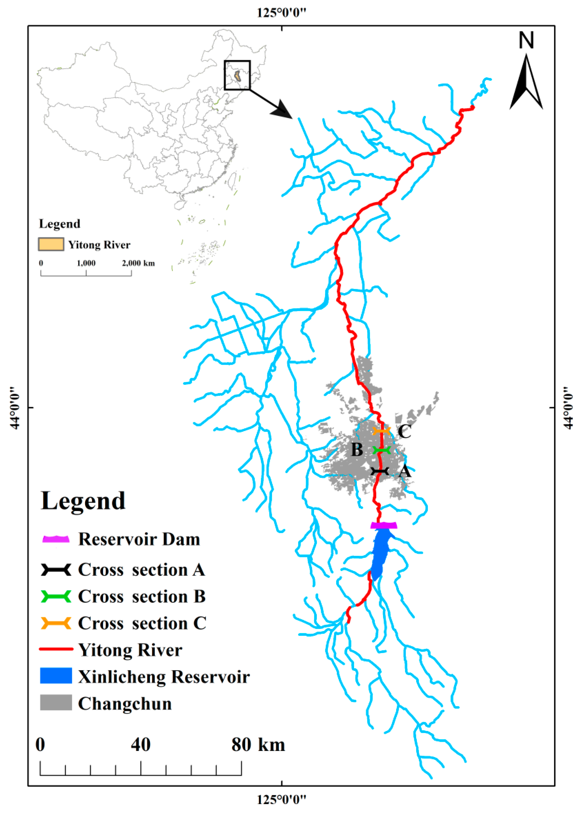
The Yitong River is the second tributary of the Songhua River, with a total length of 343.5 km and a basin area of 8440 km2. Most of the Yitong River is located in Changchun, Jilin Province, China. The Xinlicheng Reservoir is 20 km south of Changchun and was established in the upstream Yitong River. The Xinlicheng Reservoir is a water supply reservoir with a total storage of 5.92 × 10⁸ m3. The annual average water storage of the Xinlicheng Reservoir is 0.61 × 10⁸ m3. There is no clear ecological water supply purpose except supplying water for human activities.
The downstream Xinlicheng Reservoir is a natural watercourse without human disturbance, with a length of 9.77 km. After entering the urban area of Changchun, the watercourse was artificially expanded and hardened. The study area was located from downstream of the Xinlicheng Reservoir to the Yangjiawaizi Bridge of the Yitong River (Figure 1).
2.2. Ecological Water Demand Calculation
River ecological water demand includes the watercourse base flow, evaporation water demand, leakage water demand, self-purification water demand, river outside water demand, and sediment transport water demand [25,26]. In the study area, sewage from tributaries, open trenches, and sluices must be treated by sewage treatment plants, further purified by constructed wetlands, and then discharged into the Yitong River after reaching the Class V standard of surface water. The major pollution load of the basin has been effectively resolved. Therefore, self-purification water demand can be neglected in the process of calculating the river ecological water demand. Because the sediment concentration of the study area is low, the sediment transport water demand can also be neglected. The rivers of Northern China have a nonfrozen period from April to October and a frozen period from November to March in the next year. Therefore, ecological water demand is calculated from April to October.
Watercourse base water demand (, m3) can be calculated by the Tennant method. Table 1 shows the standard of flow classification [27]. Because the Yitong River is located in the water resource scarce region of Northern China, general or poor was selected as the base flow standard. The minimum ecological flows from October to March and from April to September are 10% and 30% of the average flow, respectively.
Evaporation water demand is the water needed to maintain the normal environmental function of river ecosystems. When precipitation is lower than evaporation, the lost water needs to be supplied from outside the watercourse. Evaporation water demand can be calculated by the following equation.
where is the evaporation water demand (m3); is the average water surface area (m2); is the average evaporation (mm); and is the average precipitation (mm).
Leakage water demand is the sum of water supplementation from rivers and groundwater. Leakage water demand can be calculated by the following equation.
where is the leakage water demand (m3); is the empirical coefficient; and is the leakage area (m2).
River outside water demand is mainly the vegetation water demand outside of the river, and it can be calculated by the following equation.
where is the river outside water demand (m3); is the farmland area (hm2); is the water quota of the farmland ecological environment (m3/hm2); is the urban greenbelt area (hm2); and is the water quota of the urban greenbelt ecological environment (m3/hm2).
River ecological water demand (, m3) is the sum of the watercourse base flow, evaporation water demand, leakage water demand, and river outside water demand. River ecological water demand can be calculated by the following equation.
2.3. Water Supplement Scheme Examination
2.3.1. MIKE 11 One-Dimensional Hydraulics-Water Quality Model
MIKE 11 is a one-dimensional hydraulics-water quality model that is mainly used for the simulation, design, and management of river basin systems. The basic model was established by four types of data files, including river network generalization files, riverbed section files, watercourse boundary condition files, and initial condition files. To ensure the accuracy and reliability of the results, the model was further corrected for hydrodynamics and water quality. A one-dimensional hydrodynamic-water quality model was established for the study area.
The model includes an HD hydrodynamic module, an SO controllable building module, and an AD convection diffusion module in this study. The HD hydrodynamic module is the basic module, and it can be calculated by the following equation.
where is the cross-sectional area (m2); t is the time (s); is the flow (m3/s); is the distance coordinate (m); is the inflow of the side (m3/s); is the water level (m); is the Chezy coefficient; is the hydraulic radius (m); and is the gravitational acceleration.
The SO controllable building module can simulate the operation mode of hydraulic buildings and set different operation schemes and operation orders. If a suitable control point and target point are selected, the simulated capability of the MIKE 11 model will be improved.
The AD convection diffusion module is on the basis of the HD hydrodynamic module and mainly used to establish a river water quality model. Water quality should be simulated based on the hydraulics model. The convection diffusion process of pollutants in water can be simulated by setting the attenuation coefficient and diffusion coefficient. It can be calculated by the following equation.
where is the pollutant concentration (mg/L); is the convection diffusion coefficient; is the river flow speed (m/s); is the attenuation coefficient; is the spatial displacement (m); and t is the time (s).
2.3.2. Physical Habitat Simulation Model (PHABSIM)
The habitat conditions required by aquatic organisms for growth and reproduction can be simulated by PHABSIM based on the calculation of hydraulics combined with the theory of physical habitat simulation and according to the specific flow determined from the different hydraulic conditions in the different life cycles of representative aquatic organisms. In general, fish are the dominant species in river ecosystems for measuring the ecological health of rivers [28,29]. The dominant fish species in the Yitong River is Cypriniformes. Therefore, carp was selected as the representative species to simulate habitat.
The calculation process of PHABSIM includes a hydraulic simulation and habitat simulation. The relationship between the water level and flow can be predicted by the MANSQ method of the hydraulic simulation. Furthermore, the relationship between the flow and weighted available area of the study area can be estimated based on the hydraulic simulation result and accommodation curve of the carp habitat.
3. Results and Discussion
3.1. Ecological Water Demand
3.1.1. Watercourse Base Water Demand
The watercourse base water demand of the study area can be calculated from the monthly average flow of the Yitong River (Table 2). The total watercourse base water demand of the study area was 12.56 × 10⁶ m3 from April to October.
3.1.2. Evaporation Water Demand
The average water surface area in the study area was 3.2 × 10⁶ m2. The evaporation water demand of the study area from April to October can be calculated by Equation (1) (Table 3).
3.1.3. Leakage Water Demand
The empirical coefficients of the natural and artificial sections of the Yitong River were 1.0 m and 0.5 m, respectively. The leakage water demand of the study area from April to October can be calculated by Equation (2), with a total leakage water demand of 0.17 × 10⁶ m3.
3.1.4. River Outside Water Demand
The main crop in the study area is corn. The water quota of corn is 4275 m3/hm2 [30,31]. The water supplement area of study is approximately 3300 hm2. The quota water of the greenbelt in the urban section of the river was obtained from “Water Quota (Local Standard of Jilin Province)” (DB/T389–2010). The river outside water demand of the study area can be calculated by Equation (3) (Table 4).
3.1.5. River Ecological Water Demand
The total river ecological water demand of the study area from April to October can be calculated by Equation (4) (Table 5).
The river ecological water demand of the study area from April to October is shown in Table 6. The largest ecological water demand was in August because the aquatic biodiversity and biomass were the largest in the river, and the plants were abundantly growing.
3.2. Ecological Water Supplement and Ecological Operation of the Xinlicheng Reservoir
The southeast sewage treatment plant of Changchun, which has a designed daily treatment capacity of 15 × 104 m3, is located between natural and urban sections of the Yitong River downstream of the Xinlicheng Reservoir. The daily treated water is approximately 7 × 10⁴ m3 and is discharged into the Yitong River. Therefore, the water from the sewage treatment plant in the study area is 14.70 × 10⁶ m3 from April to October, which can meet the watercourse base water demand of the urban section of the Yitong River.
The annual precipitation and effective precipitation of the study area were 575 mm and 85.50 × 10⁶ m3, respectively, based on meteorological data from Changchun from 1980 to 2011. Therefore, precipitation can meet the river outside water demand of the study area.
As mentioned above, the ecological water supplement of the Xinlicheng Reservoir for the study area includes the watercourse base water demand of the natural section, evaporation water demand, and leakage water demand. The ecological water supplement from April to October can be calculated from the monthly river ecological water demand, the watercourse base water demand of the urban section and the river outside water demand of the study area (Table 7).
3.3. Model Simulation
3.3.1. Simulation of the MIKE 11 One-Dimensional Hydrodynamic-Water Quality Model
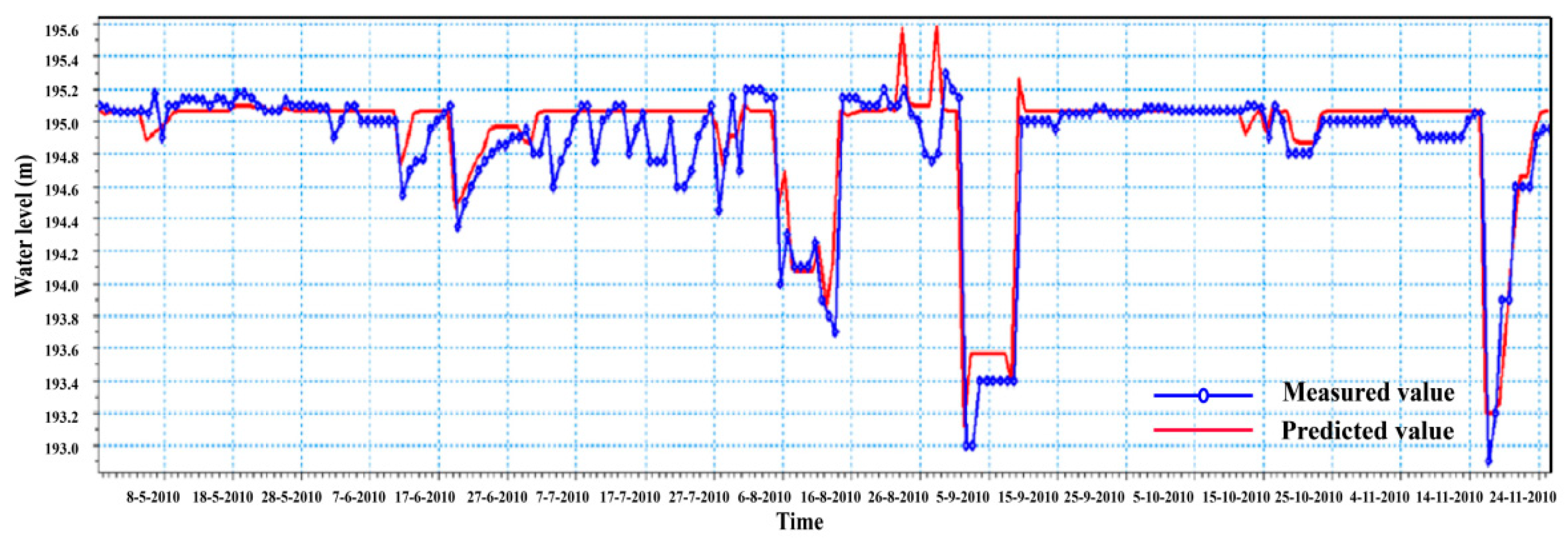
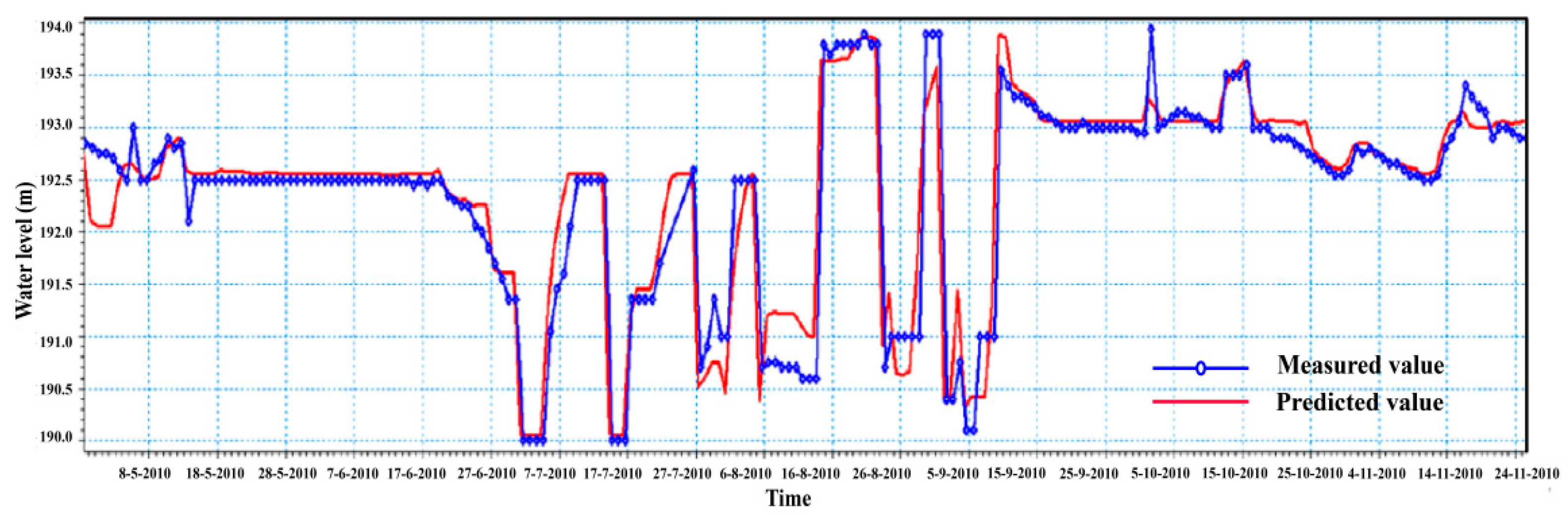
The simulation points are located at typical gate dams in the study area. The MIKE 11 one-dimensional hydrodynamic model was estimated from the measured meteorological data, boundary water level, and reservoir release in 2010. Figure 2, Figure 3 and Figure 4 show that the predicted water level by MIKE 11 and the measured water level fit well. The Nash-Sutcliffe coefficients (R2) used in evaluation of the hydrological model for Cross Sections A, B, and C are 0.96, 0.95, and 0.97, respectively. The simulated results show that the MIKE 11 model has high reliability and accuracy.
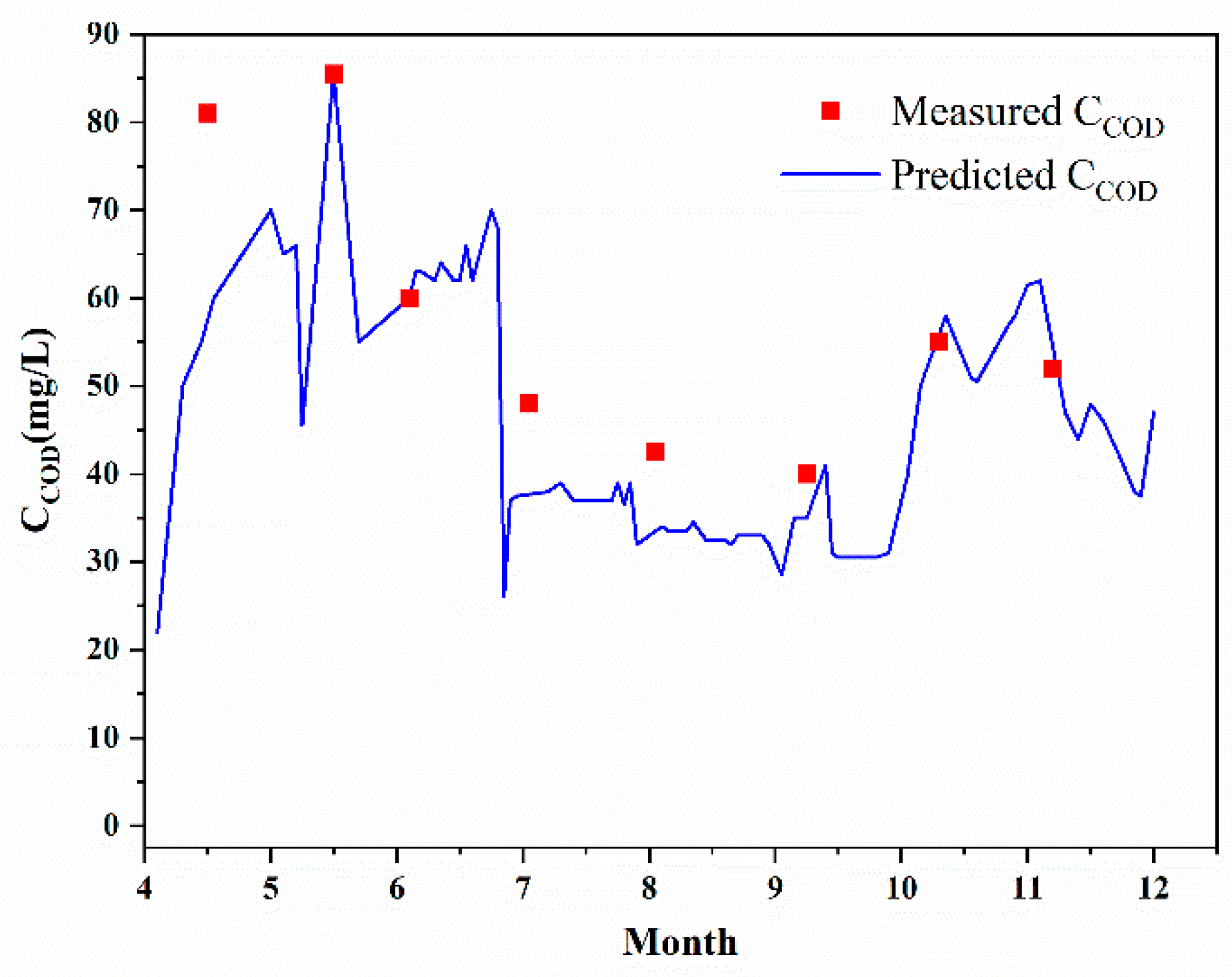
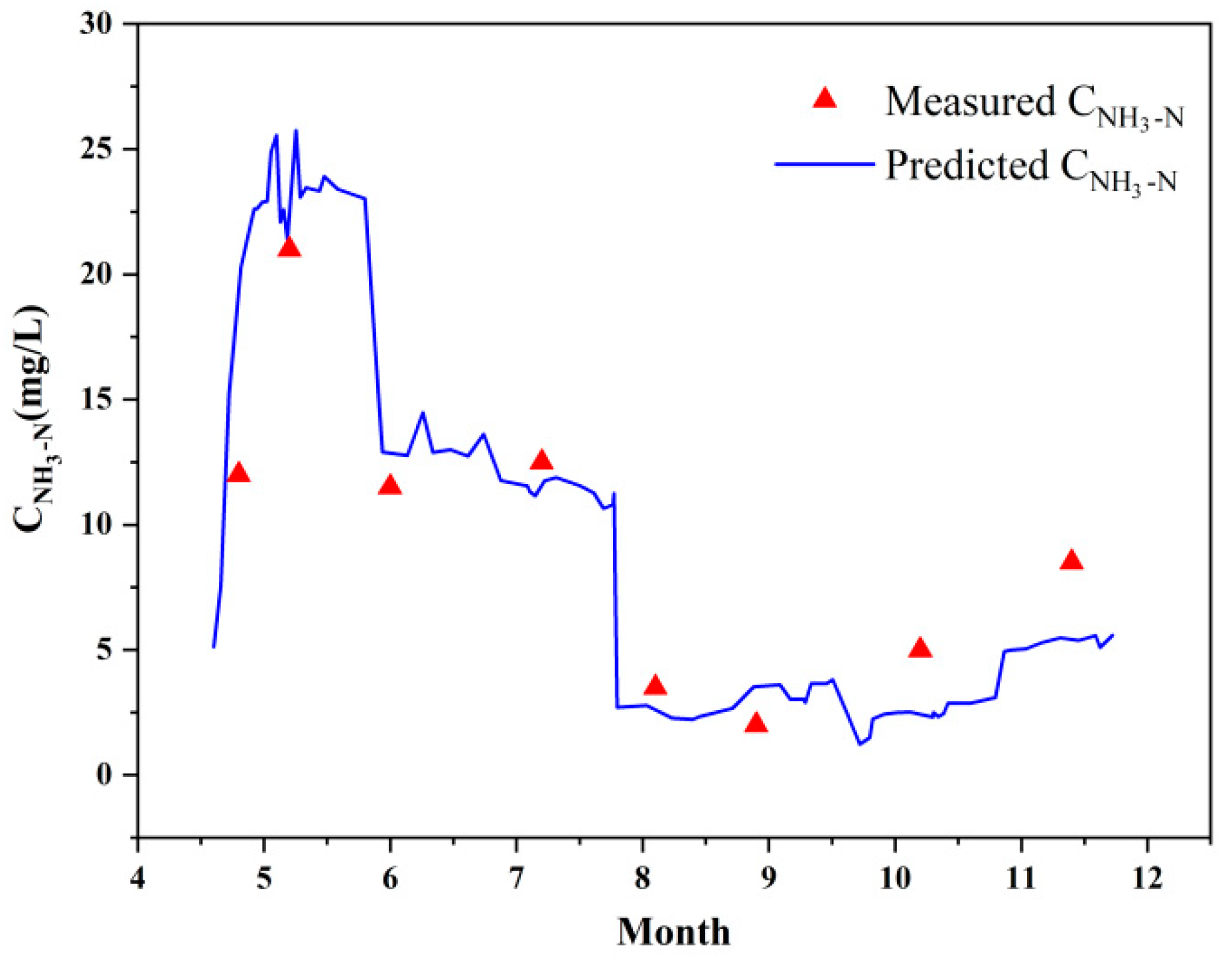
Chemical oxygen demand (COD) and ammonia nitrogen (NH3-N) are used as simulated objects in the water quality model. In the simulated process, the COD and NH3-N of the study area were calculated in 2010. Figure 5 and Figure 6 show that the predicted variations in water quality are consistent with the measured variation trends. The R2 of COD and NH3-N in the model are 0.82 and 0.84, respectively. This indicates that the simulation effect of the model is good based on the evaluation criterion of the goodness of fit. Therefore, the MIKE 11 one-dimensional hydrodynamic-water quality model can be used in the research of the study area.
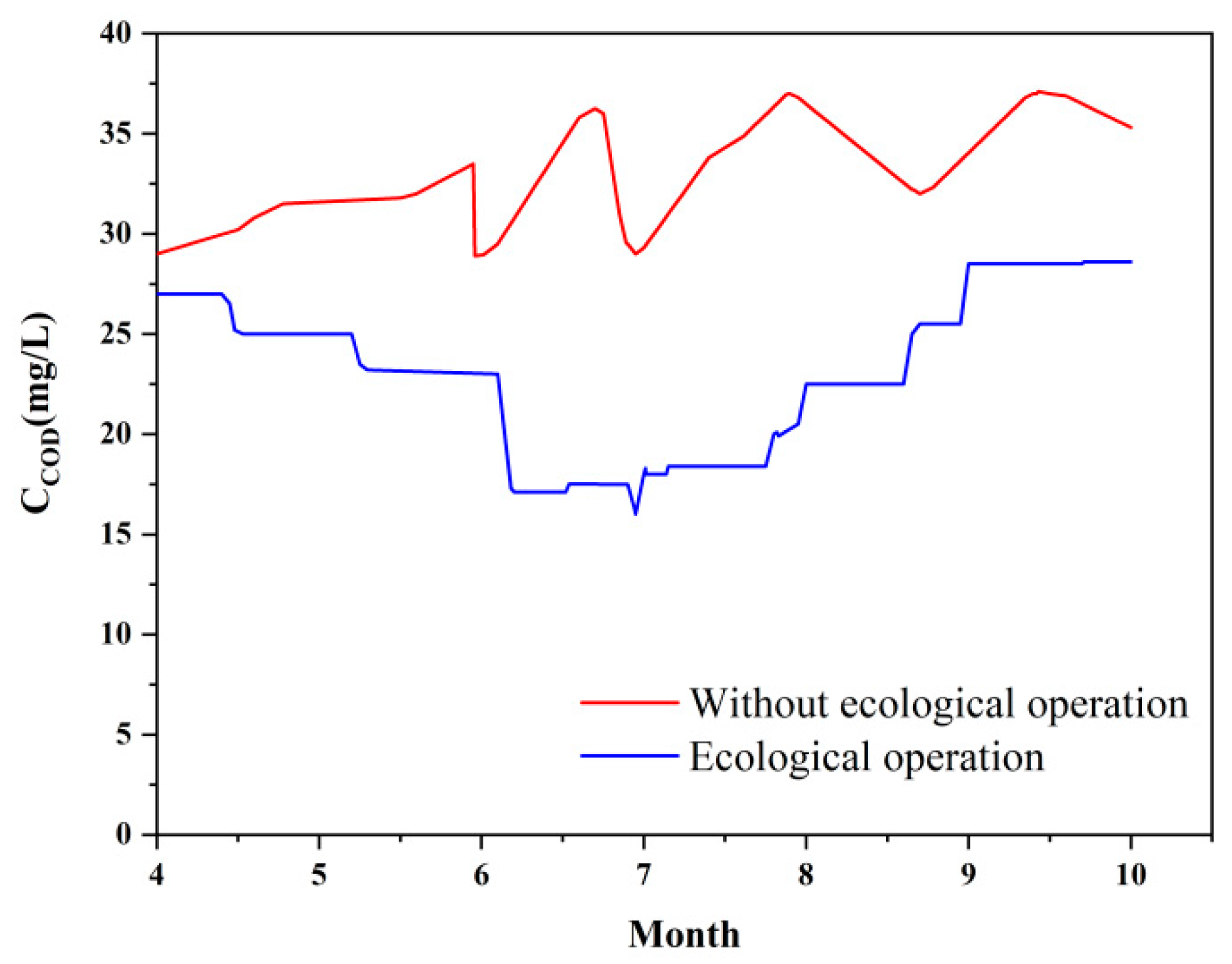
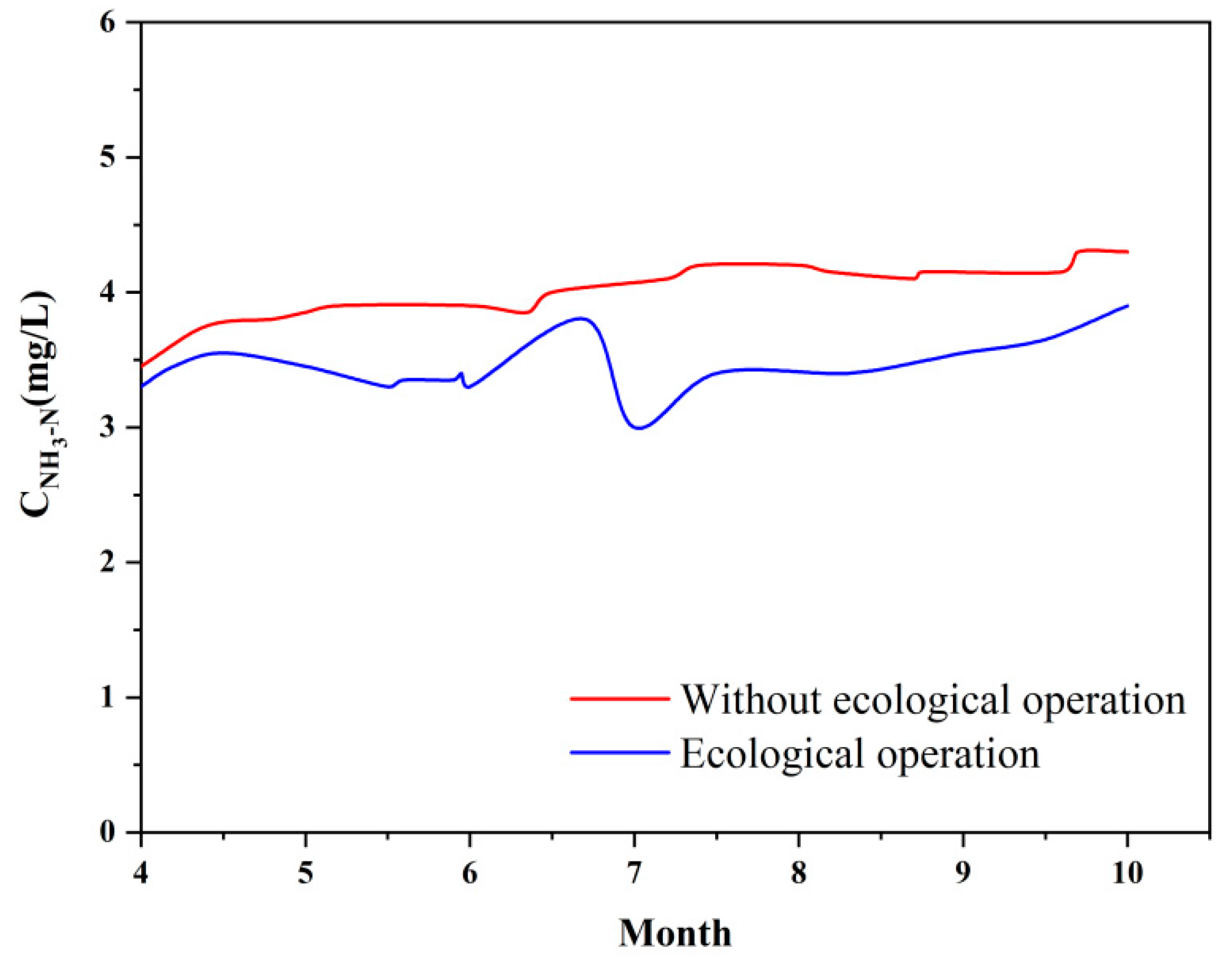
The water quality of the Xinlicheng Reservoir before and after carrying out the ecological operation scheme was simulated by the established model from April to October. After ecological operation, the COD concentration decreased significantly in the downstream river, especially from June to July (Figure 7). However, the effect of the ecological operation on the NH3-N concentration is not significant. The simulated result shows that the NH3-N concentration is 3–4 mg/L after the ecological operation, which has not yet reached the Class V standard of surface water (Figure 8). Therefore, when ecological operation is carried out, the water quality of the Xinlicheng Reservoir should also be improved. To reduce the NH3-N concentration in the river, the nonpoint source pollution of the Xinlicheng Reservoir and the Yitong River should be reduced, and the purification effect of water quality in the riverside wetlands should be promoted.
3.3.2. Simulation of the PHABSIM Model
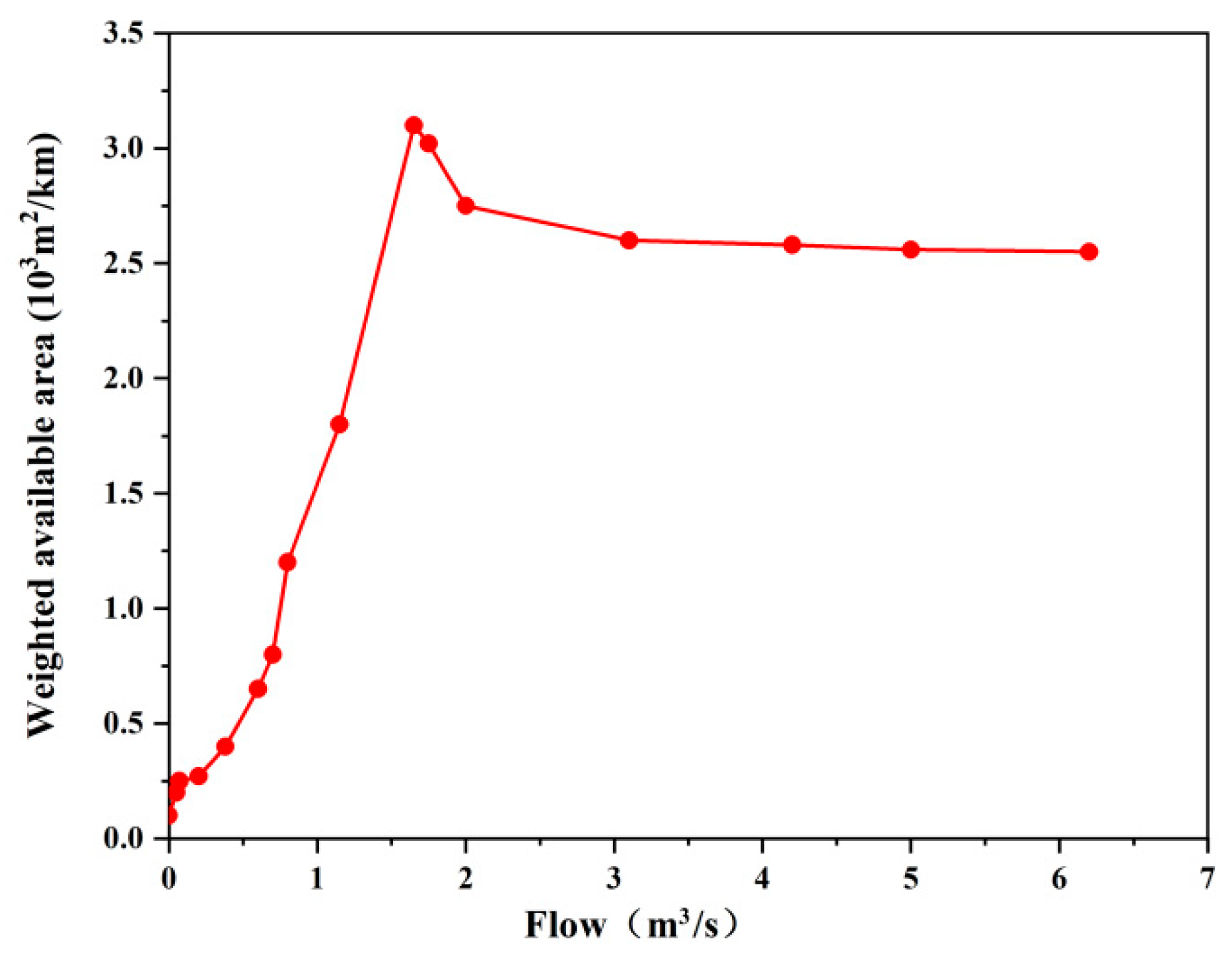
The relationship between the flow and weighted available area of the study area is shown in Figure 9. When the flow of the study area is less than 1.58 m3/s, the weighted available area of carp physical habitat increases with increasing flow. When the flow of the study area is 1.58–3.00 m3/s, the weighted available area decreases with increasing flow. When the flow of the study area is greater than 3.00 m3/s, the weighted available area reaches a steady state.
The Xinlicheng Reservoir stores water in a brief rain period and discharges floods in an abundant rain period. The flow of the river is extremely small, and the phenomenon of intermittent flow occurs in the brief rain period. However, the flow of the river can reach 50–60 m3/s in abundant rain periods, which cannot meet the need for a suitable ecological environment for carp. After ecological operation, the flow of the river can be maintained at 0.44–1.72 m3/s, and the physical habitat area of carp can remain from 0.60 × 10³ to 3.10 × 10³ m2/km from April to September. Maintaining physical habitat areas can improve the ecological environment of the river.
The simulated results of the MIKE 11 one-dimensional hydrodynamic-water quality model and PHABSIM model indicate that the ecological operation scheme can better restore the ecological environment of the Yitong River urban section. However, implementation of the water supplement scheme requires sufficient water resources from the Xinlicheng Reservoir. According to the storage capacity and hydrological statistics of the Xinlicheng Reservoir, the annual water storage of the reservoir is approximately between 44.3 × 10⁶ and 134 × 106 m3 with a guarantee rate of 50%–98%. The annual average water storage capacity is approximately 61 × 106 m3. The Xinlicheng Reservoir needs to supply 88 × 106 m3 of domestic water to Changchun every year. The supplemental water for ecological operation is approximately 15.52 × 10⁶ m3. Therefore, the water storage of the Xinlicheng Reservoir cannot guarantee the realization of ecological operation under the condition of meeting the domestic water supply. To achieve ecological operation, the inflow of the Xinlicheng Reservoir should be scientifically managed.
3.4. Watershed Management Reform and Suggestion for the Yitong River
The Xinlicheng Reservoir is a water supply reservoir in the Yitong River Basin. To solve the water shortage problem of the Xinlicheng Reservoir, the water distribution and management of the Yitong River Basin should be reformed.
3.4.1. Main Problems of Watershed Management
(1) Lack of watershed management institution
The “River Chief” was proposed to take charge of the protection and management of rivers and lakes in December 2016 and was assumed by the principles of the party and government. Jilin Province further instituted a “River Sheriff” and established specifications, task goals, and responsibilities. However, a unified management department is lacking for achieving the cooperation of public security, environmental protection, water conservancy, and animal husbandry. Each department works independently, causing conflict in water supply and affecting ecological operation.
(2) Incomplete legal framework of the basin
At present, there is only a national water law for watershed management of the Yitong River. Although river protection ordinances have been proposed, there is no law applied to basins. Law enforcement of water administration is mainly based on the “Water Law” (revised in 2016) and the “Water and Soil Conservation Law” (revised in 2010). The pertinence of the current legal framework is not strong, and the cost of violating the law is low, resulting in wasted water resources.
(3) Unscientific water distribution
The water service of the Yitong River is managed by Jilin Province and the local water service institution. Every water service institution can draw water based on requirements, resulting in an imbalance of water distribution and a reduction in reservoir inflow in the Xinlicheng Reservoir. Ecological operations cannot be carried out.
3.4.2. Countermeasures and Suggestions for Watershed Management
The following reforms and suggestions are proposed based on the main problems of water resource management in the Yitong River Basin combined with the feasibility of the ecological operation of the Xinlicheng Reservoir.
(1) Clarify department responsibility
The “Yitong River Basin Comprehensive Management and Protection Committee” should be established. This committee can further optimize water resource management, strengthen the communication and cooperation of departments, reduce the conflict between supply and demand, and maximize the utilization of water resources based on the overall Yitong River Basin.
(2) Improve law and regulation
A law is recommended to establish a basin, such as the “Yitong River Basin Management Regulation”. This law can clarify the responsibilities of departments related to water resource management and establish the legal status for the “Yitong River Basin Comprehensive Management and Protection Committee” to carry out the management work of supervision, overall planning, and coordination. The cost of violating laws can be increased, leading to the avoidance of wasting water resources.
(3) Strengthen Water Service Management
The water service group of the Yitong River Basin is proposed to manage the related work of water supply, drainage, and water pollution treatment. Competition and performance mechanisms are introduced to promote development. However, the premise of carrying out water service reform is that there is a complete and feasible legal system and management model. The reasonable and efficient allocation of water resources is still a long and complicated process.
(4) Enhance Public Participation
Public and stakeholder participation is more beneficial to manage water resources. A publicly administered institution can be introduced to give real rights for publics. Their participation can get more rights for themselves and contribute to the sustainable development of watershed. Through public participation, watershed management builds a sense of community, helps reduce conflicts, increases commitment to the actions necessary to meet environmental goals, and ultimately improves the likelihood of success for the watershed management scheme.
4. Conclusions
The calculated river ecological water demand was 79.35 × 10⁶ m3 for the urban section of the Yitong River. An ecological operation scheme was proposed for the Xinlicheng Reservoir, including a water supplement of 15.52 × 10⁶ m3 and daily release from April to October. The MIKE 11 one-dimensional hydrodynamic-water quality model and the PHABSIM model were used to simulate the water quality and physical habitat of the river urban section. The simulated results indicate that the estimated models have higher accuracy and reliability. The water quality and physical habitat were simulated by the models after carrying out ecological operation. The results show that the COD of the river can be improved, but the improvement effect of NH3-N was not obvious. Further water pollution control of the basin should be carried out. The increase in the physical habitat area and the ecological environment of the river can be improved after ecological operation. To realize the ecological operation of the Xinlicheng Reservoir, the “Yitong River Basin Comprehensive Management and Protection Committee” is proposed to establish the basin. Establishing “Yitong River Basin Management Regulations” should be suitable for the local characteristics. A water service investment group can be established to realize comprehensive reform and improvement of the water resources in the Yitong River Basin. Public participation should be enhanced to improve the likelihood of success for the watershed management scheme. This research can serve as a reference for reservoir ecological operation and watershed management in small and medium cities of the same latitude or type.
Author Contributions
Data curation: Y.C.; formal analysis: S.Z.; investigation: X.Y.; methodology: H.J.; project administration: H.J. and C.H.; resources: H.J.; software: W.W.; supervision: C.H.; validation: H.J.; writing—original draft: G.D. and H.J.; writing—review & editing: G.D. and Y.W. All authors have read and agreed to the published version of the manuscript.
Funding
This research was founded by the National Natural Science Foundation of China, grant numbers 41901116, the Foundation of Jilin Scientific and Technological Development Project, grant numbers 20190103137JH and 20190701048GH, and the Foundation of Jilin Educational Committee, grant numbers JJKH20180792KJ.
Conflicts of Interest
The authors declare that there is no conflict of interest.
References
- Dunham, J.B.; Angermeier, P.L.; Crausbay, S.D.; Cravens, A.E.; Gosnell, H.; McEvoy, J.; Moritz, M.A.; Raheem, N.; Sanford, T. Rivers are social–ecological systems: Time to integrate human dimensions into riverscape ecology and management. Water 2018, 5, e1291. [Google Scholar] [CrossRef]
- Rinaldi, M.; Gurnell, A.M.; del Tánago, M.G.; Bussettini, M.; Hendriks, D. Classification of river morphology and hydrology to support management and restoration. Aquat. Sci. 2016, 78, 17–33. [Google Scholar] [CrossRef]
- Roy, S.G.; Uchida, E.; Souza, S.P.; Blachly, B.; Fox, E.; Gardner, K.; Gold, A.J.; Jansujwicz, J.; Klein, S.; McGreavy, B. A multiscale approach to balance trade-offs among dam infrastructure, river restoration, and cost. Proc. Natl. Acad. Sci. USA 2018, 115, 12069–12074. [Google Scholar] [CrossRef] [PubMed] [Green Version]
- Yu, Y.; Wang, P.F.; Wang, C.; Wang, X. Optimal reservoir operation using multi-objective evolutionary algorithms for potential estuarine eutrophication control. J. Environ. Manag. 2018, 223, 758–770. [Google Scholar] [CrossRef]
- Yang, Z.; Yang, K.; Hu, H.; Su, L.W. The cascade reservoirs multi-objective ecological operation optimization considering different ecological flow demand. Water Resour. Manag. 2019, 33, 207–228. [Google Scholar] [CrossRef]
- Suen, J.-P.; Eheart, J.W. Reservoir management to balance ecosystem and human needs: Incorporating the paradigm of the ecological flow regime. Water Resour. Res. 2006, 42, W03417. [Google Scholar] [CrossRef]
- Meißner, T.; Schütt, M.; Sures, B.; Feld, C.K. Riverine regime shifts through reservoir dams reveal options for ecological management. Ecol. Appl. 2018, 28, 1897–1908. [Google Scholar] [CrossRef]
- Lu, S.B.; Shang, Y.Z.; Li, W.; Wu, X.H.; Zhang, H.B. Basic theories and methods of watershed ecological regulation and control system. J. Water Clim. Chang. 2018, 9, 293–306. [Google Scholar] [CrossRef]
- Ma, L.J.; Zhang, X.N.; Huan, W.; Qi, C.J. Characteristics and practices of ecological flow in rivers with flow reductions due to water storage and hydropower projects in China. Water 2018, 10, 1091. [Google Scholar] [CrossRef] [Green Version]
- He, S.; Yin, X.A.; Yu, C.X.; Xu, Z.H.; Yang, Z.F. Quantifying parameter uncertainty in reservoir operation associated with environmental flow management. J. Clean. Prod. 2018, 176, 1271–1282. [Google Scholar] [CrossRef]
- Jia, W.H.; Dong, Z.C.; Duan, C.G.; Ni, X.K.; Zhu, Z.Y. Ecological reservoir operation based on DFM and improved PA-DDS algorithm: A case study in Jinsha river, China. Hum. Ecol. Risk Assess. Int. J. 2019, 1–19. [Google Scholar] [CrossRef]
- Wang, Y.Z.; Fan, Y.B.; Bu, F.; Zhou, D.M. Quantifying effects of water and sediment regulation scheme on the sand bar in the yellow river estuary in 2014. Ecohydrol. Hydrobiol. 2019. Available online: https://doi.org/10.1016/j.ecohyd.2019.10.004 (accessed on 20 March 2020). [CrossRef]
- Kong, D.X.; Miao, C.Y.; Wu, J.W.; Duan, Q.Y.; Sun, Q.H.; Ye, A.Z.; Di, Z.H.; Gong, W. The hydro-environmental response on the lower Yellow River to the water–sediment regulation scheme. Ecol. Eng. 2015, 79, 69–79. [Google Scholar] [CrossRef]
- Dudgeon, D. River regulation in Southern China: Ecological implications, conservation and environmental management. Regul. Rivers Res. Manag. 1995, 11, 35–54. [Google Scholar] [CrossRef]
- Mi, Y.J.; He, C.G.; Bian, H.F.; Cai, Y.P.; Sheng, L.S.; Ma, L. Ecological engineering restoration of a non-point source polluted river in Northern China. Ecol. Eng. 2015, 76, 142–150. [Google Scholar] [CrossRef]
- Lv, J.; Xu, J.L.; Wang, H.X.; Li, W.; Liu, X.J.; Yao, D.F.; Lu, Y.; Zheng, X. X Study on ecological protection and rehabilitation technology of a reservoir-type water source in the northeastern region of China. Hum. Ecol. Risk Assess. Int. J. 2019, 25, 1802–1815. [Google Scholar] [CrossRef]
- Suen, J.-P. Determining the ecological flow regime for existing reservoir operation. Water Resour. Manag. 2011, 25, 817–835. [Google Scholar] [CrossRef]
- Kingsford, R.T. Ecological impacts of dams, water diversions and river management on floodplain wetlands in Australia. Austral Ecol. 2000, 25, 109–127. [Google Scholar] [CrossRef]
- Daldorph, P.W.G. A reservoir in management-induced transition between ecological states. Ecol. Bases Lake Reserv. Manag. 1999, 395–396, 325–333. [Google Scholar]
- Thompson, R.M.; Bond, N.; Poff, N.L.; Byron, N. Towards a systems approach for river basin management—Lessons from Australia’s largest river. River Res. Appl. 2019, 35, 466–475. [Google Scholar] [CrossRef] [Green Version]
- den Brandeler, F.; Gupta, J.; Hordijk, M. Megacities and rivers: Scalar mismatches between urban water management and river basin management. J. Hydrol. 2019, 573, 1067–1074. [Google Scholar] [CrossRef]
- Taha, R.; Dietrich, J.; Dehnhardt, A.; Hirschfeld, J. Scaling effects in spatial multi-criteria decision aggregation in Integrated River Basin Management. Water 2019, 11, 355. [Google Scholar] [CrossRef] [Green Version]
- Delipınar, Ş.; Karpuzcu, M. Policy, legislative and institutional assessments for integrated river basin management in Turkey. Environ. Sci. Policy 2017, 72, 20–29. [Google Scholar] [CrossRef]
- Xue, L.Q.; Wang, J.; Zhang, L.C.; Wei, G.H.; Zhu, B.L. Spatiotemporal analysis of ecological vulnerability and management in the Tarim River Basin, China. Sci. Total Environ. 2019, 649, 876–888. [Google Scholar] [CrossRef] [PubMed]
- Yang, Z.F.; Cui, B.S.; Liu, J.L.; Wang, X.Q.; Liu, C.M. Theory, Methods and Practices of Ecological Environment Water Demand; Science Press: Beijing, China, 2003. [Google Scholar]
- Jiang, H.B.; He, C.G.; Luo, W.B.; Yang, H.J.; Sheng, L.X.; Bian, H.F.; Zou, C.L. Hydrological Restoration and Water Resource Management of Siberian Crane (Grus leucogeranus) Stopover Wetlands. Water 2018, 10, 1714. [Google Scholar] [CrossRef] [Green Version]
- Men, B.H.; Yu, T.; Kong, F.L.; Yin, H. Study on the minimum and appropriate instream ecological flow in Yitong River based on Tennant method. Nat. Environ. Pollut. Technol. 2014, 13, 541–546. [Google Scholar]
- Herman, M.R.; Nejadhashemi, A.P. A review of macroinvertebrate- and fish-based stream health indices. Ecohydrol. Hydrobiol. 2015, 15, 53–67. [Google Scholar] [CrossRef] [Green Version]
- O’Brien, A.; Townsend, K.; Hale, R.; Sharley, D.; Pettigrove, V. How is ecosystem health defined and measured? A critical review of freshwater and estuarine studies. Ecol. Indic. 2016, 69, 722–729. [Google Scholar] [CrossRef]
- Han, N.N.; Wang, Y.R.; Zhou, Q.Y.; Li, S.M.; Ye, L.T.; Jin, J.H. Analysis on Spatial and Temporal Variations of Maize Irrigation Water Requirement in Jilin Province. IOP Ser. Earth Environ. Sci. 2018, 128, 012024. [Google Scholar] [CrossRef] [Green Version]
- Tan, M.H.; Zheng, L.Q. Different Irrigation water requirements of seed corn and field corn in the Heihe River Basin. Water 2017, 9, 606. [Google Scholar] [CrossRef] [Green Version]
Figure 1.
Location of the study area.

Figure 2.
Simulated result of the water level at Cross Section A.

Figure 3.
Simulated result of the water level at Cross Section B.

Figure 4.
Simulated result of the water level at Cross Section C.

Figure 5.
Simulated results of the COD concentration in 2010.

Figure 6.
Simulated results of the NH3-N concentration in 2010.

Figure 7.
Simulated COD concentration before and after the ecological operation scheme.

Figure 8.
Simulated NH3-N concentration before and after the ecological operation scheme.

Figure 9.
Weighted available area of the study area vs. flow.


Table 1.
Tennant method for the recommended base flow standard.
| Qualitative Description of Flow Values and Corresponding Habitat | Recommended Base Flow Standard (The Percentage of Average Flow) | |
|---|---|---|
| General Water Period (October–March) | Fish Spawning Breeding Season (April–September) | |
| Maximum | 200 | 200 |
| Optimum range | 60–100 | 60–100 |
| Very good | 40 | 60 |
| Good | 30 | 50 |
| Better | 20 | 40 |
| General or poor | 10 | 30 |
| Poor or minimum | 10 | 10 |
| Severe degradation | <10 | <10 |
Table 2.
Basic flow and water demand of the study area from April to October.
| Month | April | May | June | July | August | September | October | Average/Total |
|---|---|---|---|---|---|---|---|---|
| Monthly average flow (m3/s) | 0.62 | 1.23 | 1.99 | 4.88 | 5.69 | 1.37 | 0.92 | 2.39 |
| Minimum ecological flow (m3/s) | 0.19 | 0.37 | 0.60 | 1.46 | 1.71 | 0.41 | 0.09 | 0.69 |
| Monthly water demand (106 m3) | 0.48 | 0.97 | 1.52 | 3.83 | 4.48 | 1.04 | 0.24 | 12.56 |
Table 3.
Evaporation water demand of the study area from April to October (106 m3).
| Month | April | May | June | July | August | September | October | Total |
|---|---|---|---|---|---|---|---|---|
| Evaporation water demand | 0.63 | 0.88 | 0.51 | 0.06 | 0.11 | 0.33 | 0.30 | 2.82 |
Table 4.
River outside water demand of the study area.
| Section | Area (hm2) | Water Quota (m3/hm2) | Total Water Demand (106 m3) |
|---|---|---|---|
| Natural | 3300 | 4275 | 14.10 |
| Urban | 12426 | 4000 | 49.70 |
| Total | 15726 | - | 63.80 |
Table 5.
Ecological water demand of the study area (106 m3).
| Water Demand | Watercourse Base | Evaporation | Leakage | River Outside | Total |
|---|---|---|---|---|---|
| Amount | 12.56 | 2.82 | 0.17 | 63.80 | 79.35 |
Table 6.
River ecological water demand of the study area from April to October (108 m3).
| Month | April | May | June | July | August | September | October | Total |
|---|---|---|---|---|---|---|---|---|
| Total | 0.08 | 0.10 | 0.11 | 0.16 | 0.18 | 0.09 | 0.07 | 0.79 |
Table 7.
Ecological water supplement and daily release of the Xinlicheng Reservoir from April to October.
Table 7.
Ecological water supplement and daily release of the Xinlicheng Reservoir from April to October.
| Month | April | May | June | July | August | September | October | Total |
|---|---|---|---|---|---|---|---|---|
| Ecological water supplement (106 m3) | 1.13 | 1.87 | 2.05 | 3.91 | 4.61 | 1.39 | 0.56 | 15.52 |
| Daily release (m3/s) | 0.44 | 0.70 | 0.79 | 1.46 | 1.72 | 0.54 | 0.21 | — |
© 2020 by the authors. Licensee MDPI, Basel, Switzerland. This article is an open access article distributed under the terms and conditions of the Creative Commons Attribution (CC BY) license (http://creativecommons.org/licenses/by/4.0/).
Share and Cite
MDPI and ACS Style
Deng, G.; Yao, X.; Jiang, H.; Cao, Y.; Wen, Y.; Wang, W.; Zhao, S.; He, C. Study on the Ecological Operation and Watershed Management of Urban Rivers in Northern China. Water 2020, 12, 914. https://doi.org/10.3390/w12030914
AMA Style
Deng G, Yao X, Jiang H, Cao Y, Wen Y, Wang W, Zhao S, He C. Study on the Ecological Operation and Watershed Management of Urban Rivers in Northern China. Water. 2020; 12(3):914. https://doi.org/10.3390/w12030914
Chicago/Turabian StyleDeng, Guangyi, Xiaohan Yao, Haibo Jiang, Yingyue Cao, Yang Wen, Wenjia Wang, She Zhao, and Chunguang He. 2020. "Study on the Ecological Operation and Watershed Management of Urban Rivers in Northern China" Water 12, no. 3: 914. https://doi.org/10.3390/w12030914
Note that from the first issue of 2016, this journal uses article numbers instead of page numbers. See further details here.