Article

Ancient Coastal Changes Due to Ground Movements and Human Interventions in the Roman Portus Julius (Pozzuoli Gulf, Italy): Results from Photogrammetric and Direct Surveys

1
Dipartimento di Scienze e Tecnologie, Università degli Studi di Napoli Parthenope, Centro Direzionale Is. C4, 80121 Napoli, Italy
2
Dipartimento di Scienze della Terra, dell’Ambiente e delle Risorse, Università degli Studi di Napoli Federico II, Largo San Marcellino, 10, 80138 Napoli, Italy
3
Dipartimento Asia Africa e Mediterraneo, Università degli Studi di Napoli L’Orientale, Piazza S. Domenico Maggiore, 12, 80134 Napoli, Italy
*
Author to whom correspondence should be addressed.
Water 2020, 12(3), 658; https://doi.org/10.3390/w12030658
Submission received: 30 January 2020 / Revised: 24 February 2020 / Accepted: 25 February 2020 / Published: 29 February 2020
(This article belongs to the Special Issue Relative Sea-Level Changes and their Impact on Coastal Zones)

Abstract

:
This research aims to evaluate the amount of vertical ground movements during Roman times inside the archaeological area of Portus Julius (Gulf of Pozzuoli) using high-precision surveys on the most reliable archaeological sea-level markers. Measuring the submersion of ancient floors, structural elements belonging to a former fish tank, and several roman pilae, two different relative sea levels (RSLs), related to the beginning and the end of the first century BCE, respectively, −4.7/−5.20 m and −3.10 m MSL (mean sea level), were detected. A photogrammetric survey was carried out in order to produce a 3D model of the fish tank. The results in terms of the RSL variations have enabled us to reconstruct a morpho-evolution of the ancient coastal sector during the last 2.1 kyBP. At the beginning of the first century BCE, the area was characterized by a sheltered gulf with numerous maritime villae located along the coast. In 37 BCE, the construction of the military harbour of Portus Julius strongly modified the paleogeography of the sector, which was also affected by a prevailing subsidence at least until the end of the first century BCE (year 12 BCE), when the port was converted into a commercial hub.

1. Introduction

The study of past geomorphological events may reveal the vulnerability of a specific area to dangerous phenomena, even if they have very long return times and/or very slow rates of action [1]. Moreover, such studies are fundamental to build site-specific process response models, which are useful to predict the consequences of future environmental changes (climatic, tectonic, etc.) [2,3,4].
Regarding particular volcanic coastal areas, vertical ground movements and related changes of the relative sea level [5,6,7,8,9,10,11,12,13,14,15,16,17,18,19,20] represent crucial information for hazard forecasting based on the style and rate of landscape changes over the time.
The present study concerning the Gulf of Pozzuoli, located in the wide caldera of the Campi Flegrei volcanic complex (S. Italy), can be framed in this context.
The study area is known worldwide for the striking evidence of vertical ground movements, many of which are related to the ruins (both emerged and submerged) of ancient buildings and coastal structures scattered throughout this territory [21,22,23,24,25,26,27,28].
Around 770 BCE, the establishment of a commercial base (emporion) on the island of Pithekoussai (Ischia) and the later foundation of the first Greek colony of Kyme (now Cuma) in Southern Italy marked the beginning of the human presence in the territory in the historical period.
However, the great urbanization of Campi Flegrei occurred during the Roman age, after the settlement in 194 BCE of the Roman colony of Puteoli (now Pozzuoli) in the same place of the old Samian colony of Dicearchia. Puteoli soon became the main commercial port of Rome and, therefore, a centre of maritime traffic so intense and important that it earned the appellation of Delus minor (i.e., small Delo, from the important Aegean free port) [29,30,31]. Moreover, this territory had a strategic military value hosting two important military harbours. Portus Julius was built in 37 BCE by M. Vipsanius Agrippa and served as a naval military base during the war against Sextus Pompeius at the end of the Roman republican era. The Misenum port, instead, was built in 12 BCE after the abandonment of Portus Julius, which became a commercial hub.
Since the end of the II century BCE, the CF coasts hosted the largest and most luxurious seaside villas built especially in the second half of the first century BCE. The numerous thermal springs, connected with the volcanism of the region, the proximity to Rome and the amoenitas of the natural landscape attracted many wealthy people from the Roman aristocracy of the Late Republican period. This resulted in the consequence of quick occupation, with private properties, of the whole coastal sector. The almost uninterrupted sequence of luxurious villas, visible by the sea in the Gulf of Naples, was precisely described in a famous quotation by Strabone [32].
Currently, the largest part of the ancient coastal strip, including all the buildings and maritime structures, is submerged due to the overall subsidence starting at the end of the Roman period [25,33].
When better preserved and carefully investigated, the remains of those structures also reveal the evidence of relative sea level (RSL) changes that occurred during the Roman period. The typologies and dimensions of these remains may document the strong human capacity to modify the coastal physiography of the time, such as the opening of navigable channels to access the coastal lakes (see Lucrino and Averno lakes during the construction of the Portus Julius) or the artificial infill by which a 2 km long reach of Puteoli coast (ripa puteolana) was advanced tens of meters [30].
The purpose of this study is to present the results of high-precision surveys on the most reliable archaeological markers of the ancient sea level, aimed at the evaluation of the ground movements affecting the area of Portus Julius during the Roman period.
This data can be considered very relevant to issues regarding the relative sea-level positions at the time of the construction of the harbour [23,25,26,27,28,34]. In addition, the ancient Portus Julius is one of the largest underwater archaeological sites in Italy and represents a great point of interest for marine archaeology studies [35,36,37,38,39]. This site-located in the Underwater Archeological Park of Baia is a perfect example of submerged archaeological heritage that records fundamental traces of the ancient coastal morphologies, highly vulnerable to present coastal processes because of recent submersion [40,41]. Indeed, a further aim of this research is to document, through a high-precision photogrammetric survey, the fish tank detected at Portus Julius, which represents the most significant evidence of the relative sea-level variations that occurred in the area in the few decades between the first century BCE and the first century CE. In fact, with respect to the historical sources, the area is well-dated and documented and can be used as a key site in the RSL studies.
However, the study of Mediterranean submerged archaeological sites as indicators of sea-level oscillations is a challenge of great scientific interest [14,15,42,43,44,45,46,47,48].
In the framework of caldera modelling studies, these results can be considered crucial to evaluate the exacerbated effects of vertical ground movements on the accelerated sea-level rise due to the ongoing climate change, in terms of coastal modification and consequent human adaptations.

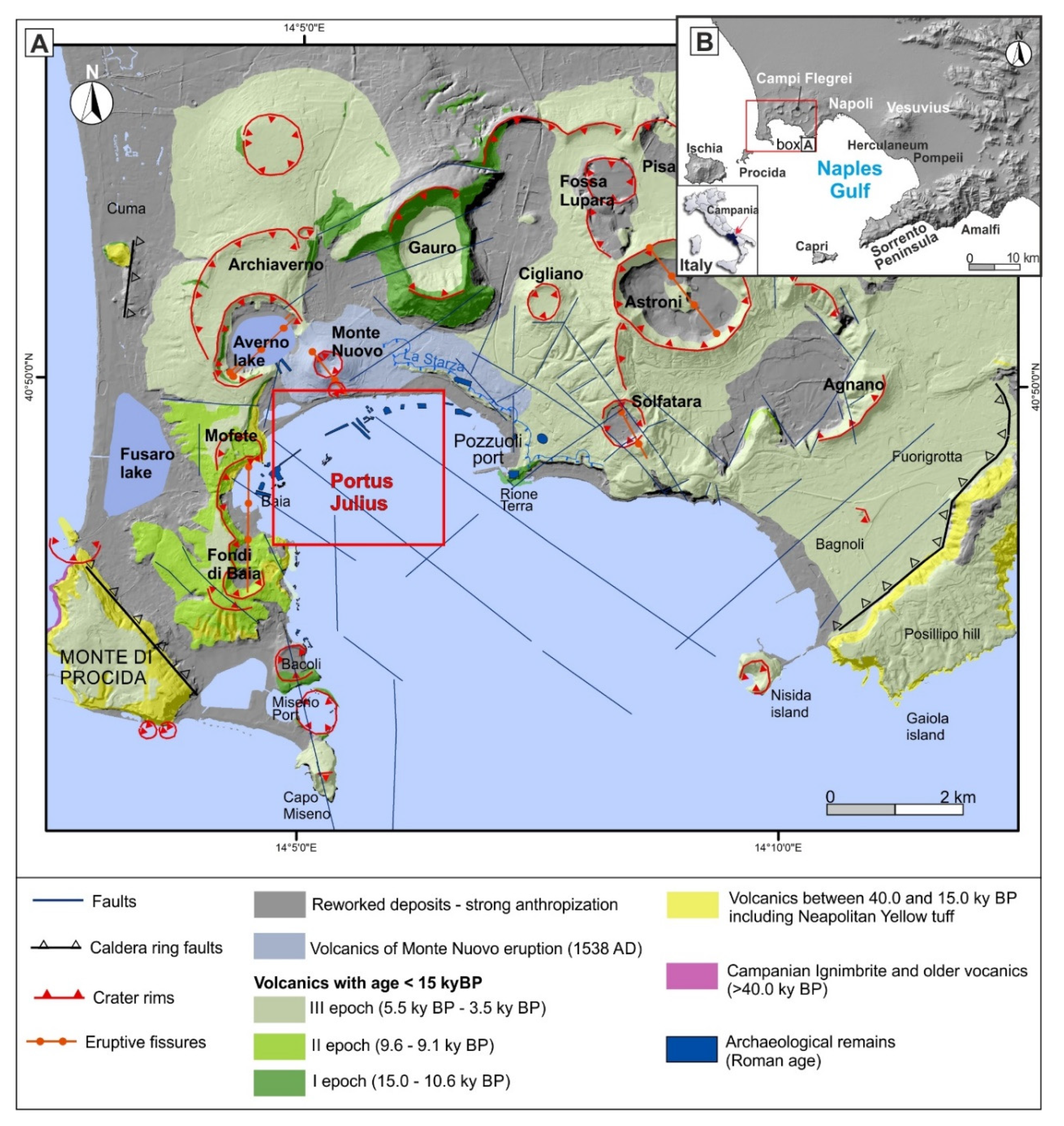
2. Geological Setting

The Gulf of Pozzuoli (Figure 1) belongs to the northern sector of the Gulf of Naples and covers an area of about 130 km2 [49]. The coasts of the Gulf are mainly exposed to the waves coming from the SW sector (fetch amplitude 45° and average distance of 485 km, [50]), and were modified in the last millennia due to both the physiography and the volcano-tectonic ground movements affecting the whole area. In fact, Pozzuoli Gulf is located along the northern margin of the Campi Flegrei caldera ([51] and references therein).
The Campi Flegrei volcanic area is a poly-calderic system made of structural depressions covering an area of about 230 km2. The volcanism of the area can be divided into pre- and post-caldera activities [53,54,55].
The pre-caldera activity is characterized by three main different eruptive events [50], interspersed with periods of volcanic quiescence, starting with the Campanian Ignimbrite (CI) super eruption, which occurred 40 ky BP [56,57].
After the CI eruption, the northern part of the just-formed caldera was invaded by the sea and progressively filled with tuffites and subordinate submarine flows. The second volcanic event, which led to the formation of the Masseria del Monte Tuff, occurred 29.3 ky BP [52,58] and it preceded the last eruption that has contributed to the formation of the caldera 15 ky BP, called the Neapolitan Yellow Tuff (NYT) Eruption [59,60].
The volcanic activity following the NYT eruption was characterized by about 72 explosive and effusive eruptions, recognized in stratigraphic records over an area of about 1000 km2 [61]. These eruptions, both explosive and effusive, have produced lava flows and pyroclastic deposits and they occurred in three epochs of volcanic activity, between 15 and 10.6 ka BP, between 9.6 and 9.1 ka BP, and between 5.5 and 3.5 ka BP [62]. After a quiescence of about 3000 years, the last volcanic event has deeply modified the morphology of the area with the formation of the Monte Nuovo tuff cone in 1538 CE [21,28,63,64].
The study area, located in the central sector of Pozzuoli Gulf, is characterized by a low sandy coast at the feet of the Monte Nuovo Lithosome. This unit, with a height of 100 m, is made of a grey cineritic deposit rich in blackish scoriae in its upper part ([52] Figure 1). In particular, the coastal sector of Portus Julius is bordered southward by La Starza marine terrace, uplifted 30–40 m MSL about 5 ky BP [61,65], whose depositional sequence recorded the older coastal changes in the area, with an alternation of marine sediments and pyroclastic levels.

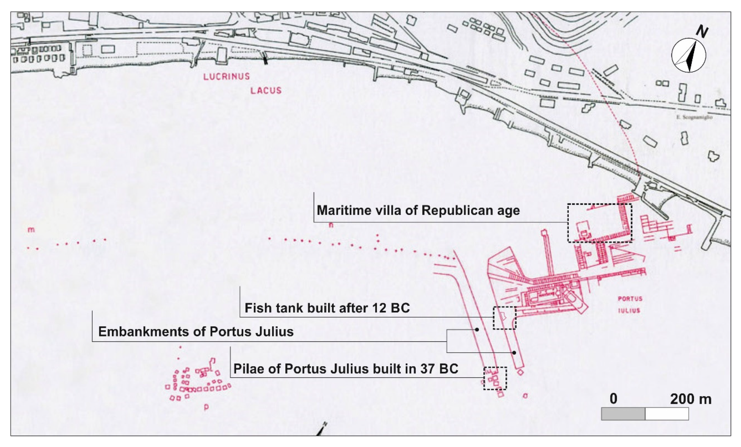
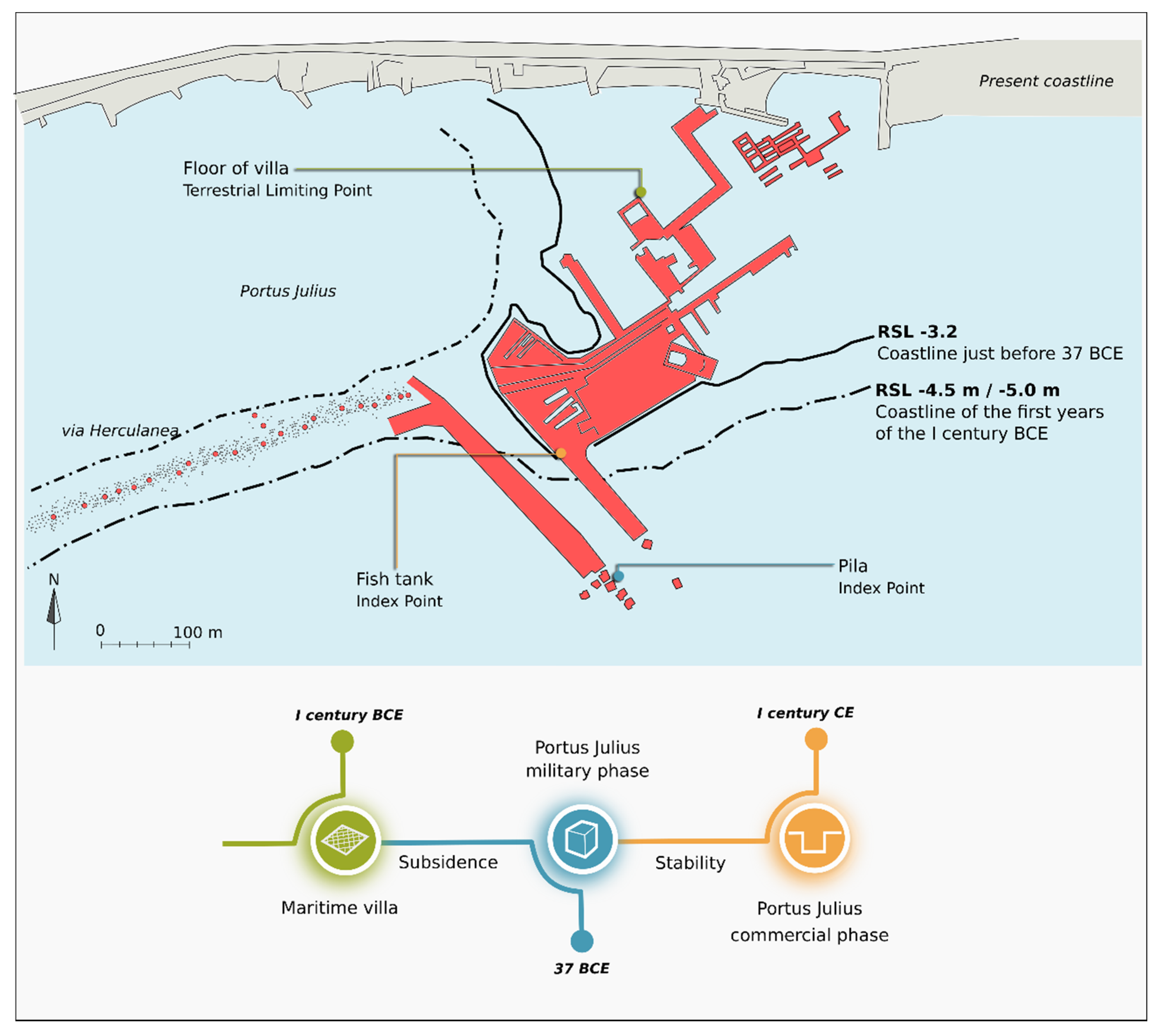
3. Archeological Setting

During the Roman period, Portus Julius (Figure 2) experienced at least two different construction phases: a brief military phase during which the entry channel was built and a long commercial phase during which the area was restored with the construction of numerous warehouses (horrea) and fish tanks.
The first phase started in 37 BCE, when the coastal sector enclosed between the Lucrino and the Averno Lakes was chosen by Agrippa for the construction of a new military harbour system, named precisely Portus Julius. At that time, the Lucrino Gulf appeared as a lake due to the construction of via Herculanea, built on a spit formed between Baiae and Puteoli [32]. When the military port was positioned into the Lucrino lake, the narrow opening linking Averno and Lucrino lakes was enlarged and fortified by walls to create a sheltered landing for warships [37,39,66].
During this period, the whole area was renovated, as testified by the construction of a new main entrance to Portus Julius, formed by a channel with two 300 m long banks and protected by pier structures with huge pilae in opus caementicum. These were realized following the principles well described by Vitruvius [67].
However, the use of the area for military purposes, related to the quick and victorious war against the pirate fleet of Sextus Pompeius, was very short and the harbour was converted in a commercial basin around the year 12 BCE, together with the relocation of the military port in the nearby Misenum, favoured by the presence of a natural triple-basin port and by a less problematic tendency to sand infilling. With the change of purposes, Portus Julius was rethought and restructured, with the transformation and the adaptation of military environments into warehouses and fish tanks, also along the entry channel to Lake Lucrino [37,38,39].
In this study, the fish tank cut into the embankment of the entry channel was deeply surveyed and analysed, as it can be considered as good evidence of the renovation that occurred after 12 BCE. This fish tank is particularly interesting as it represents one of the few examples of fish tanks related to commercial activities and not to private maritime villas. The existence of a tank within the entry channel can be related to the presence of a fish market or areas intended for the production of the garum. According to the historical sources, Cassiodoro [68] in particular, the harbour was abandoned during the IV century CE due to a bradyseismic crisis.

4. Methods

4.1. Direct Survey on Archaeological Features
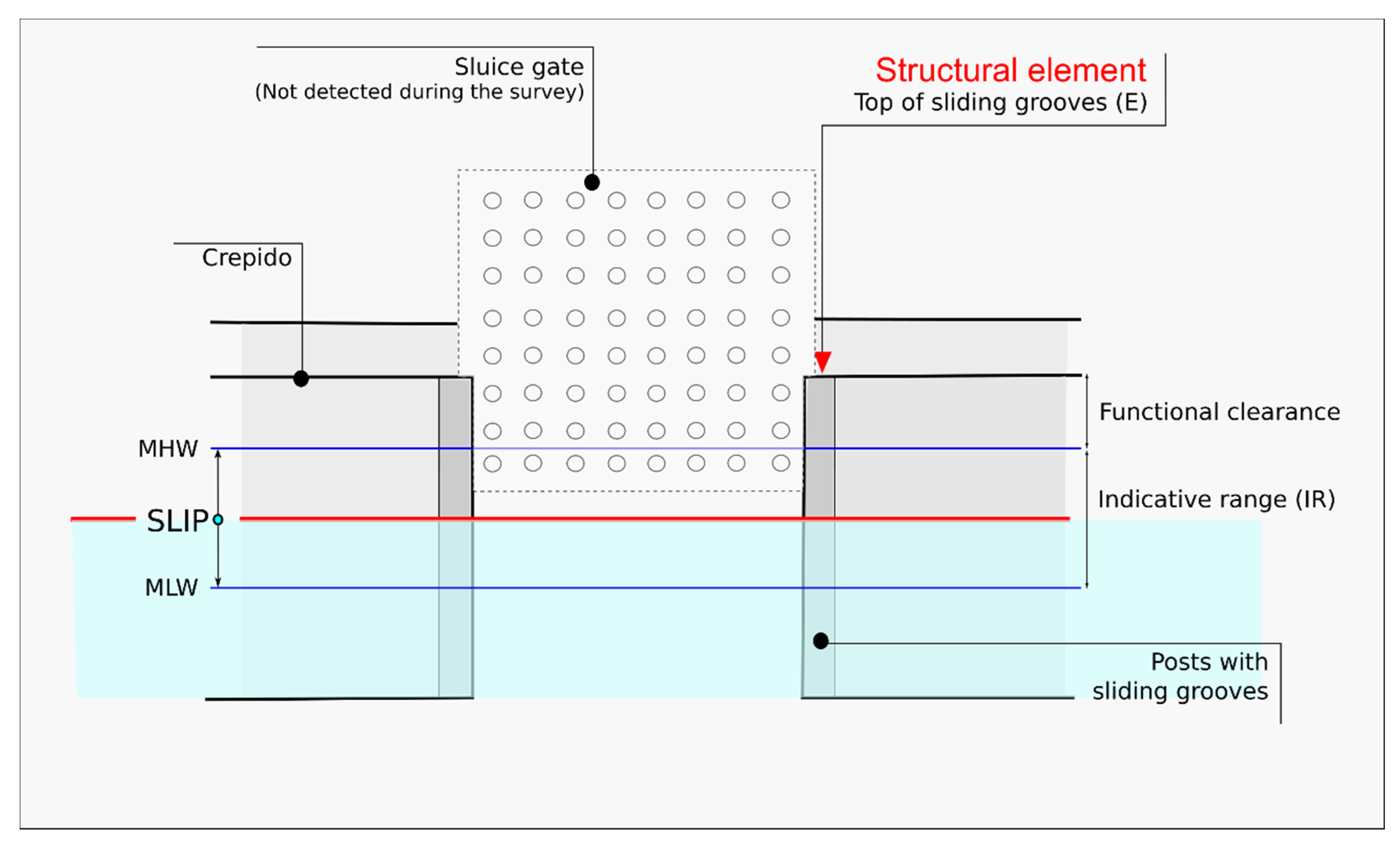
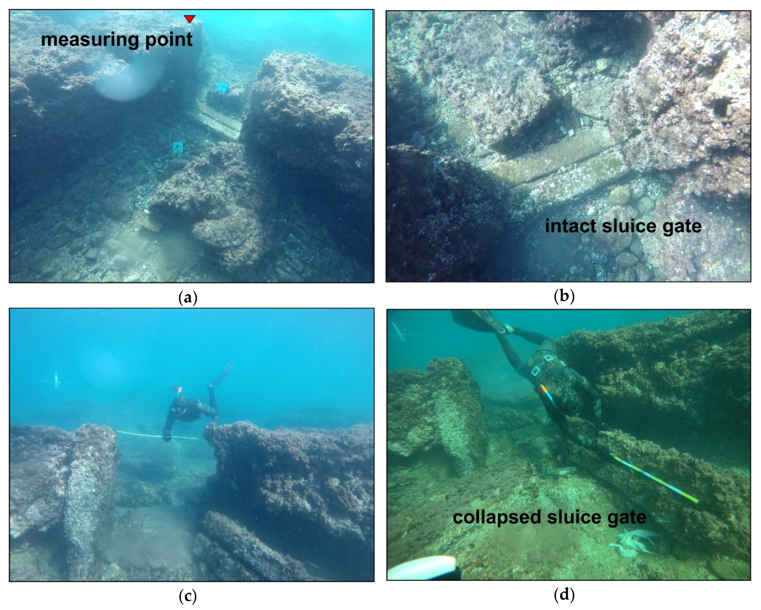
In this study, direct surveys were carried out on three different types of archaeological sea level markers. Two markers are directly related to the former sea level, and therefore considered high-precision sea level index points (SLIPs) [70], i.e., a fish tank and a port structure. The third marker is a floor belonged to a maritime villa built on the ancient sandy coast, therefore considered a terrestrial limiting point (TLPs), intended as a marker positioned above the ancient sea level [70].
The survey was planned by evaluating the bibliographic, cartographic, and videographic documentation describing the archaeological area. It was carried out to measure the size and submersion of the archaeological structures investigated with direct methods by a team of scuba divers composed of two geomorphologists and an archaeologist. The divers were assisted by two surveyors on a support boat, equipped with a GIS-GPS cartographic station used to georeference the position of the targets.
The submersion measurements were corrected with respect to the tidal level and the barometric pressure taken from the tide gauge in the Port of Naples.
The following describes the main features of the archaeological sea-level markers selected for the reconstruction of the ancient sea-levels.

4.1.1. Fish Tanks

The Roman fish tanks (piscinae) consisted of single or multiple tanks used for fish farming [69], interconnected with the open sea through channels. This direct connection of constructional elements with the sea level, and specifically with the tidal range, makes these structures excellent indicators of ancient sea levels.
In their treaties, Varro and Columella [71,72] described the different construction techniques for fish tanks, which varied according to the coastal type [73,74,75,76].
There are essentially three constructional elements directly linked to the sea level at the time of fish tank’s construction [73,75,76,77,78]: crepidines (a foot-walk border surrounding the tank and the internal pools); channel system (canals which allowed tidally controlled water exchange); cataractae (closing gates located at the access of the canal into the basin or at the communication passage between each tank).
In this study, the submersion measurements concerned the Cataractae, considering that these structural elements were perfectly preserved in their original position. The measurements were carried out on top of the vertical posts cut by grooves, originally excavated in order to guide the vertical movement of the old gate, made of a sheet of lead or stone with several small holes (diameter between ~3 and ~9 centimetres, Figure 3).
These constructional elements are considered high-resolution SLIPs of the second construction phase of Portus Julius. The submersion measurements (elevation bsl, E) were carried out on the top of the sliding grooves because these structural elements were always built above the highest tide level (mean high water, MHW, sensu Shennan et al. [70], obtaining at least 0.2 m of functional clearance (fc) (after Lambeck et al. [76]). Moreover, the original elevation of the structural elements above the ancient MSL, indicative meaning (IM) sensu Shennan et al. [70], can be evaluated considering that the IM describes the relationship between the marker and the former sea-level and that it is composed of two elements:
  • Indicative range (IR), the elevation range over which the marker forms;
  • Reference water level (RWL), the mid-point of the above-mentioned range [14,70].
In the case of fish tanks, the indicative meaning and the related IR can be defined with high precision as reported in the ancient texts of Varro and Columella [71,72]. Thereby, while the functional clearance is considered a constant amount according to the archaeological interpretations, in the case of a fish tank, the IR varies between the mean high water (MHW) and the mean low water (MLW) (Figure 3).
Finally, by correcting the E measurements with respect to the functional clearance (fc cataracta = 0.2 m), the RSL (SLIP) can be evaluated [78,79] using the equation:
SLIP cataracta (m) = E − fc cataracta − IR/2
where IR = (MHW–MLW) is the indicative range.
Concerning the vertical uncertainty, the functional clearance derived from archaeological interpretations cannot be included in its calculation (after Vacchi et al. [14]). Consequently, this uncertainty is equal to ± (MHW to MLW)/2. Taking into account that the tidal range (MHW to MLW) in the Gulf of Naples is about 0.4 m [80], the vertical uncertainty of our measurement is ±0.2 m.

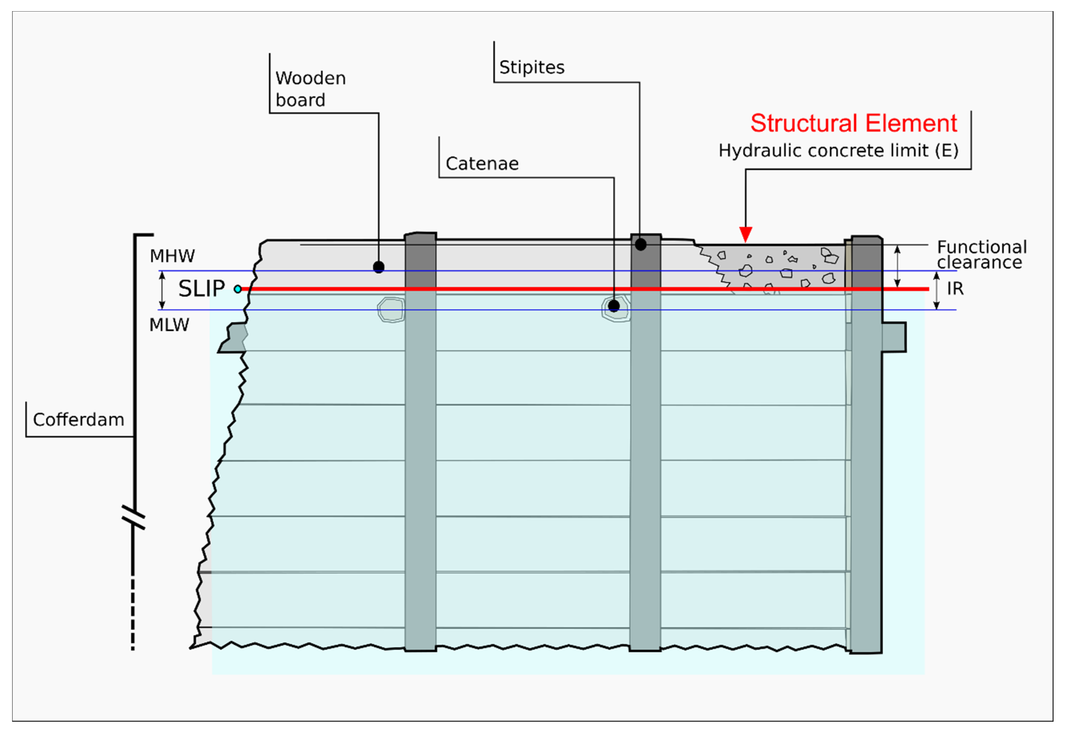
4.1.2. Ancient Pier Structures

Port structures are excellent sea-level indicators, as they were built in direct functional relation with the ancient sea level [77], even if it is not always easy to identify a precise measuring point.
During the planning phases of the survey, the pilae protecting the embankments of Portus Julius were chosen as high-precision archaeological sea-level markers related to the first construction phase of Portus Julius. The submersion measurements were carried out on the upper part of the pila made in hydraulic concrete, here considered a SLIP according to Mattei et al. [16].
The pilae are Roman square construction made of hydraulic concrete and built on the sea bottom with their upper part generally emerged [81]. These cubes were built forming single or multiple lines, often connected by arches, and called opus pilarum. This kind of structure was largely distributed in the Mediterranean area after the discovery of Roman hydraulic concrete during the II century BCE [16,82,83].
Due to the importance in Roman engineering, this construction material, mainly made of pulvis puteolanus (Pozzolana), was mentioned by several ancient authors, including Vitruvius [67], Strabo [32], and Plinius [84]. This volcanic ash—largely detectable in Campi Flegrei caldera—is composed of reactive aluminosilicates, mixed with irregular stones or tuff aggregate and it has the main characteristic of being hardened by the sea to a strength “which neither the waves nor the force of the water can dissolve” (Vitruvius, [67]). When seawater infiltrates in the concrete, it dissolves some of the ash and, rather than undermining the structure, the alkali fluid that is left allows minerals to strengthen it [85].
Since its discovery, the concrete became the most used material for the construction of ports and coastal structures [16,82,83], as confirmed by the analyses of several pilae located in Italy (Portus Julius, Anzio, Cosa, Santa Liberata, Brindisi), Israel (Caesarea), Egypt (Alexandria), and Greece (Crete) [76] carried out during the ROMACONS project since 2002.
The Roman pilae were built on the seabed using an innovative building technique, consisting of wooden cofferdams with an open upper surface and sides made of vertical oaken poles (destinae) held together by horizontal beams (catenae). The cofferdam technique, described by Vitruvius [67] in 15 BCE, required that the hydraulic concrete be cast and set directly underwater [16,82,83].
The emerged parts of these port facilities were often built with the same concrete but set in sub-aerial environments, and were therefore less resistant due to the absence of seawater infiltration.
The port structures were often refined with the typical roman opus reticulatum (covering made up of small square blocks forming a grid) or opus testaceum (covering made up of simple brickwork, [16,82,83,86,87].
In this study, the pilae protecting the embankments of Portus Julius were used as SLIP (sensu Shennan et al. [70]) by detecting the concrete change (i.e., the limit between the areas in hydraulic concrete and the areas in concrete totally laid in a subaerial environment) (Figure 4) [16,88].
In fact, as described by Vitruvius [67], the cofferdams filled with hydraulic concrete had to emerge from the ancient mean sea level by an amount equal to a wooden board (about 0.50 m). Consequently, according to this archaeological interpretation, the elevation range over which the marker forms (IR) is directly related to the tidal range and varies between the mean high water (MHW) and the mean low water (MLW).
Knowing the submersion measurement (emersion bsl, E) and the amount of the functional clearance (fcpila), by determining the original elevation above the ancient MSL (indicative meaning, IM, (sensu Shennan et al. [70])) it is possible to evaluate the SLIP (RSL) by using the following equation:
SLIPpila (m) = E – fc pila – IR/2
where IR = (MHW to MLW) is the indicative range, and fc pila (m) = 0.50 – MHW is the functional clearance with respect to the high tide.
As in the previous case of the fish tank, concerning the vertical uncertainty, the functional clearance derived from archaeological interpretations cannot be included in its calculation (after Vacchi et al. [14]). Consequently, this uncertainty is equal to ± (MHW–MLW)/2. Considering that the tidal range (MHW–MLW) in the Gulf of Naples is about 0.4 m [80], the vertical uncertainty of our measurement is ± 0.2 m.
During the surveys, we observed that the hydraulic concrete cast underwater and immersed in the sea water during the last 2000 years effectively strengthened its hardness [83].
Indeed, the part of the pila built in the emerged environment, with the same hydraulic concrete or with another material, is currently deteriorated more than the part cast underwater (Figure 5).
The divers recognized some areas where the hydraulic concrete was visible, thanks to its typical characteristics perfectly coincident with those described for the pila of Nisida by Mattei et al. [16]. These sectors detected on the upper face of the pila—where the subaerial concrete was totally eroded—appear as deeper areas with a flat and sub-horizontal morphology (Figure 5). These areas were always positioned underneath the areas in sub-aerial concrete that appeared very eroded with a rugged morphology (Figure 5).

4.1.3. Ancient Buildings

To detect the elevation of an ancient RSL, the ruins of coastal buildings can be profitably studied, particularly the remnants of ground floor pavements and entrance thresholds. Their relations to the coeval sea level is not so direct and simple so as to be able to use a universal rule to derive a past marine level from it. However, they permit to fix a maximum height limit of the RSL (terrestrial limiting point, TLP) by considering at what minimum height it was safe to build a residence or a warehouse to minimize the risks of invasion by storm waves and/or the penetration of groundwater (Figure 6) [77,89]. Concerning the local wave climate, during winter and autumn, the storm events are characterized by mean wave height values up to 4.8 m, associated with atmospheric low-pressure systems; the spring and summer are characterized by low wave height values ranging from 0.4 to 0.6 m [90,91,92].
In naturally sheltered coastal plains, such as the one where Portus Julius is located (see section geological setting), we assume that, for a site located right behind the backshore, the minimum height necessary to minimize the effects of storm waves (i.e., functional clearance) ranged between 1.5 and 2 m MSL) [77,89].

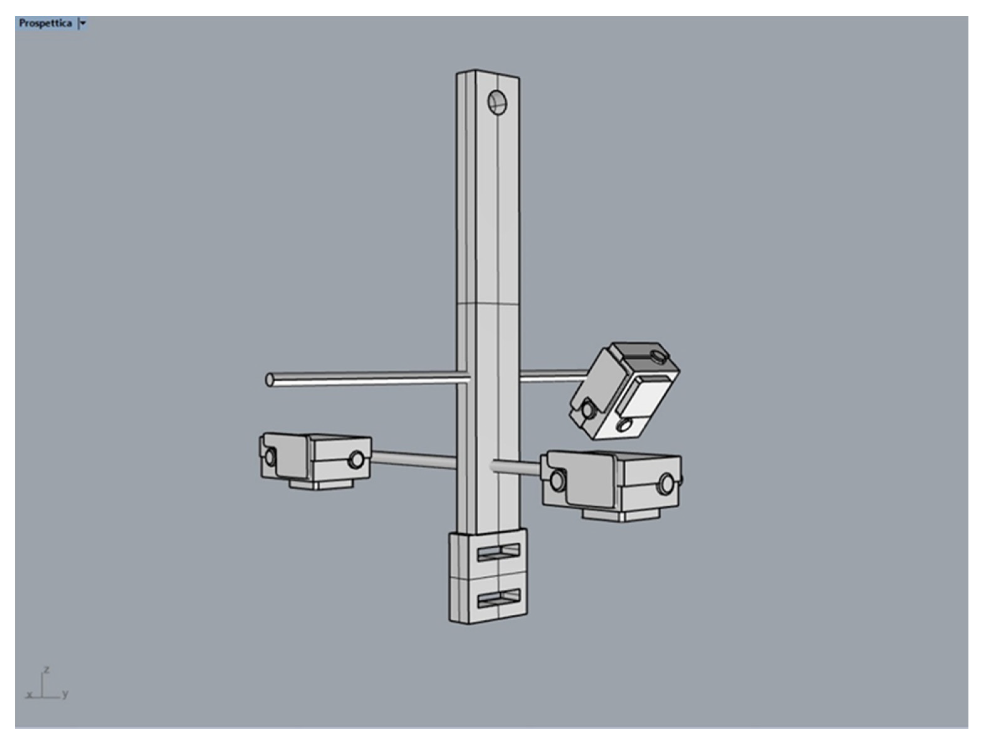
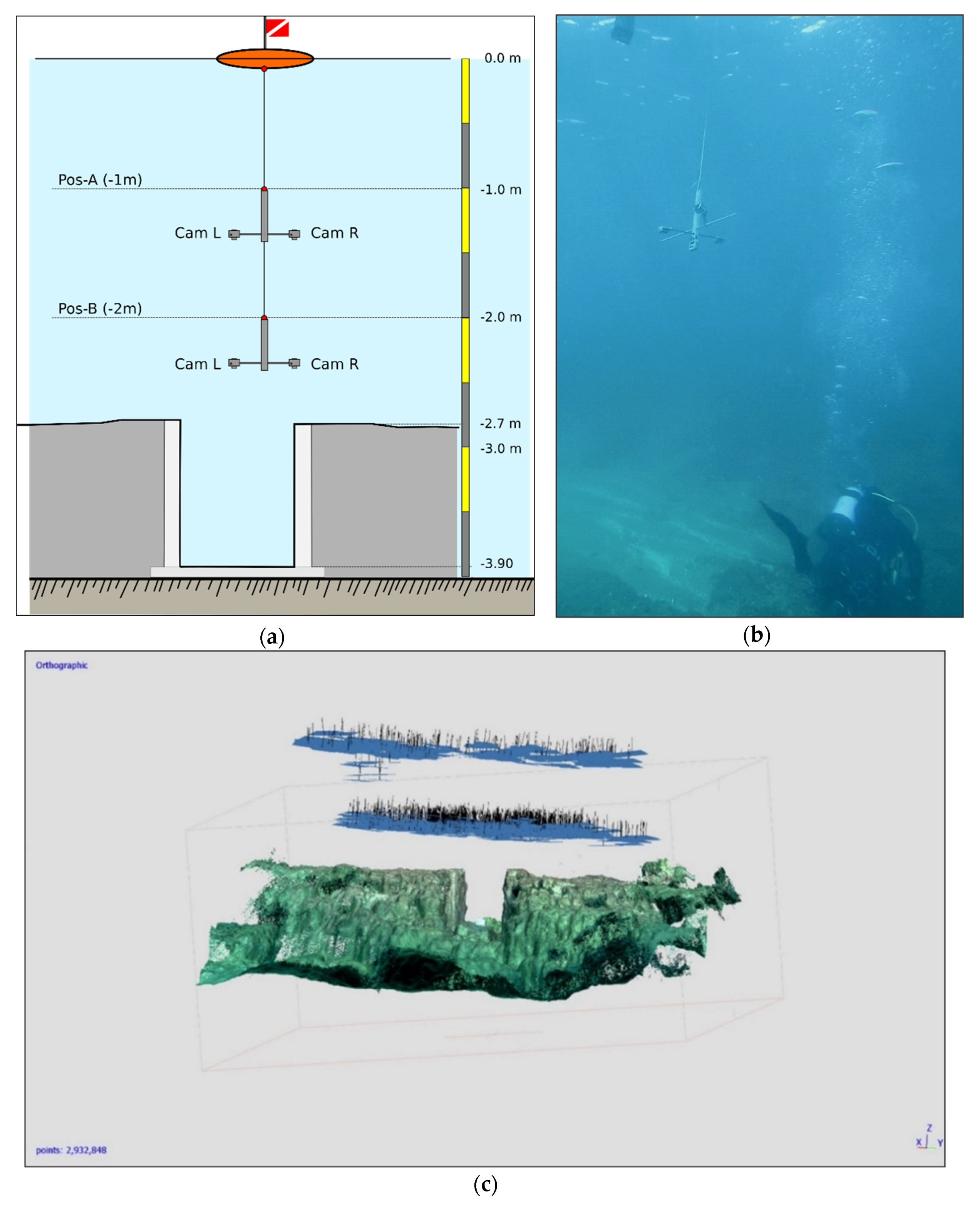
4.2. Photogrammetric Survey

The fish tank here studied represented the key element of our geoarchaeological interpretations in terms of ground movements occurred during the Roman times, due to its strategic position. The sluice gate of this fish tank was built directly by cutting the channel embankment. This led to the assumption that it was therefore built in the second construction phase of the Portus Julius, according to Benini and Giacobelli [37]. Therefore, in this area, a high precision photogrammetric survey has been carried out both to obtain a detailed morphometric analysis of this functional element and to preserve a 3D documentation of this important and unique historical testimony, also considering the extreme fragility of this underwater landscape.
The survey was planned using a photogrammetric system consisting of three high-resolution cameras, two parallel to the vertical optical axis in the nadiral position with respect to the sea-bottom and a third inclined with respect to the bottom by about 30° (Figure 7).
The stereoscopic base (b) and the submersion of the system were chosen in relation to the bathymetry of the study area and the level of the resolution of the three-dimensional model of the submerged findings, with our settings for the cameras ensuring a minimum overlap of 80% during the survey (Figure 8). Taking into account the characteristics of the video cameras, to ensure a transversal overlap of at least 80%, the stereoscopic base was chosen equal to 30 centimeters. The depth of the photogrammetric system was modified during the survey to guarantee both an adequate completeness of the three-dimensional model and its resolution (see Figure 8).
As shown in Figure 8a, the photographic system was towed by a rope connected to an emerged float and moved by divers. This system provides two basic positions, namely position A at −1 m and position B at −2 m below the sea surface.
During the survey, two videoshots were taken in sequence, the first with the photogrammetric system at an altitude of −1 m MSL (Positon A in Figure 8a) and the second at an altitude of −2 m MSL (Positon B in Figure 8a) and therefore close to the target.
The photogrammetric 3D model of the surveyed fish tank was obtained in three two steps [88]:
  • The videos at 30 fps recorded by the two Xiaomi cameras (previously calibrated in an underwater environment close to the study area to achieve the inner orientation parameters) were synchronized by the use of the trigger system and the images were extracted using a frame every six seconds. More than one thousand 1920 × 1080 images were thus obtained.
  • The alignment procedure of the images and the dense point cloud extraction was performed using the Agisoft Metashape software. The 3D model was not georeferenced as it was not possible to determine the coordinates of the control points; however, some linear measurements made by the diver directly on the underwater structure made it possible to scale the dense point cloud.
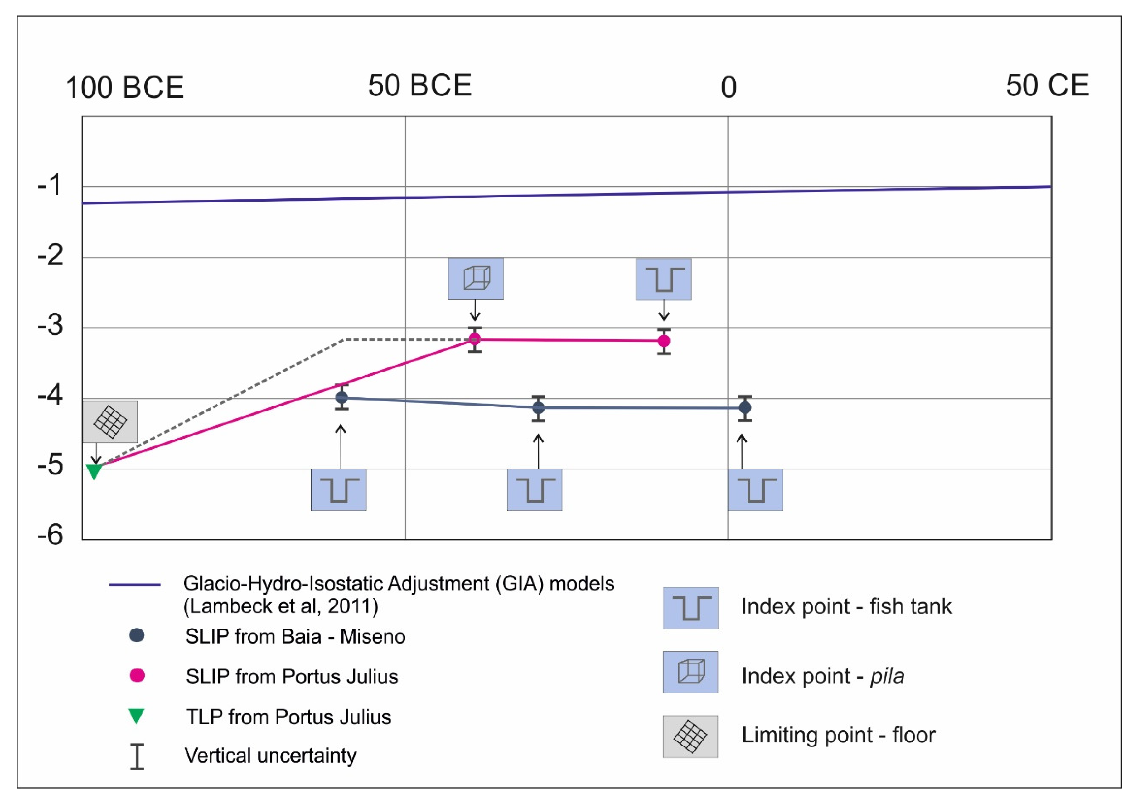
5. Results

5.1. Maritime Villa (I Century BCE)

In the first instance, the survey involved an area near to Portus Julius but already existing before its construction, where a maritime villa was built at the end of the Republican Age (I century BCE) [39]. The submersion of the better-preserved mosaic floor was measured at −3.2 m MSL (Figure 9) by using a metric roll and depth gauge. Consequently, by correcting this measurement with respect to the functional clearance, a SLIP (RSL) at −4.70/−5.20 m MSL was deduced. This amount of submersion was also measured in the best-preserved parts from the nearby via Herculanea (dated I century BCE).

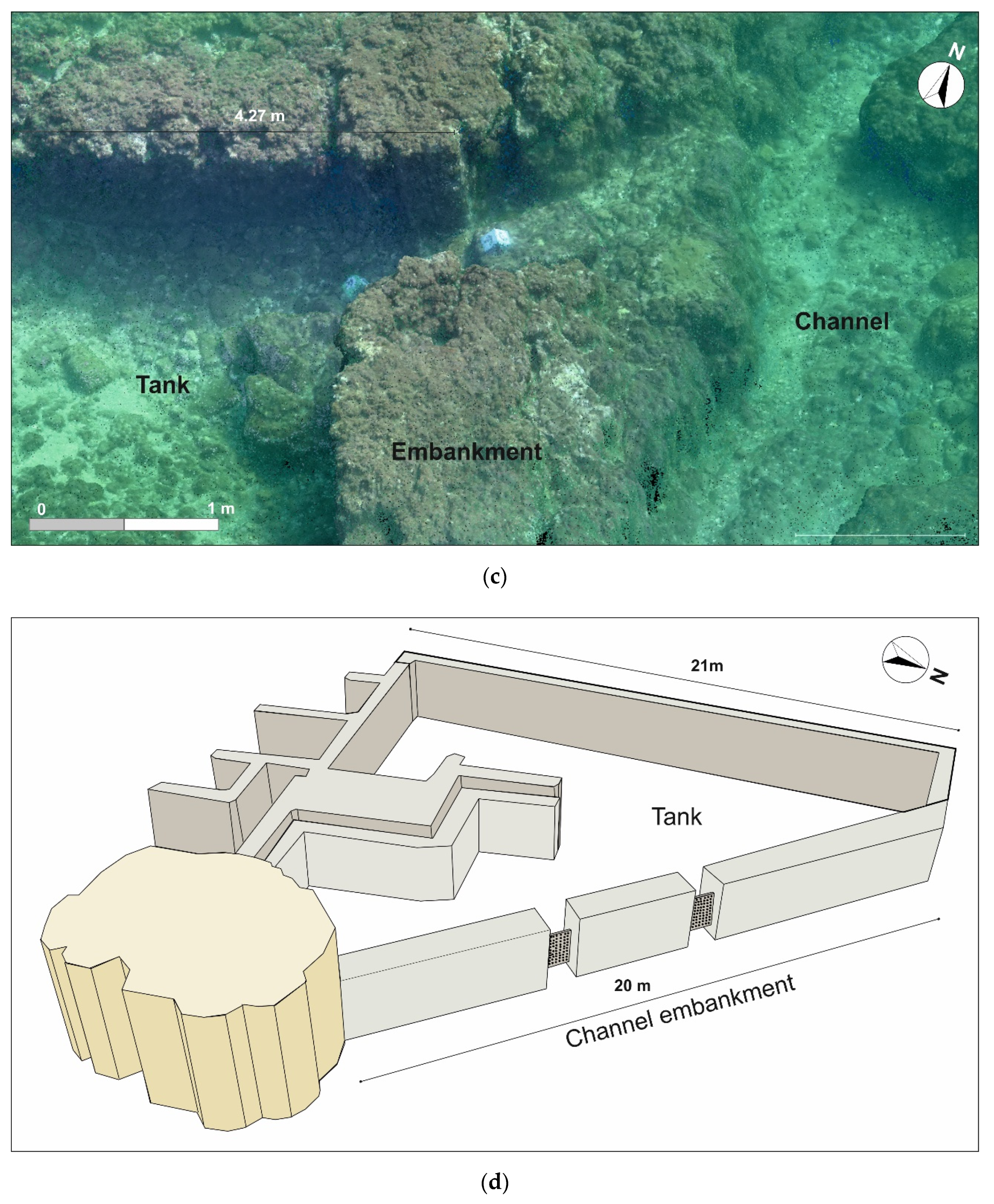
5.2. Fish Tank (12 BCE)

The second archaeological structure, surveyed with direct and indirect methods, was the fish tank of Portus Julius, the main archaeological sea level markers related to the second constructive stage of the harbour after 12 BCE, when its usage switched from a military to a commercial one. This archaeological interpretation was endorsed by the position of the fish tank cutting the embankment of the entry channel of Portus Julius, as clearly shown in the photogrammetric reconstruction (Figure 8a). In fact, according to Benini and Giacobelli [37], the relationship between the fish tank and the military port seems incongruous. It is more likely that the embankment was cut afterward—when the port became commercial—to allow the conversion of the rooms adjacent to the embankment in the fish tank for commercial use.
To better describe the fish tank, a morphometric analysis of the photogrammetric point cloud was performed (Figure 10b–d). The photogrammetric reconstruction was crucial both for the evaluation of the elements related to the study of the past relative sea levels and for the documentation of this singular fish tank built for commercial use, with a great cultural value.
The triangular fish tank, with a size of 20 × 22 × 16 m, is entirely made of tuff and it appears to be carved into the embankment of the entry channel [37], constructed in the year 37 BCE by the order of Agrippa. Along the external wall, two different ancient cataractae are clearly identifiable (Figure 10 and Figure 11) and, while the southern one is still in situ, the northern one is partially destroyed and shows one of the two vertical posts collapsed.
The submersion of the top of the sliding grooves located along the posts still in loco was measured at −2.70 m MSL and, by correcting this measurement by using the Equation (1), a SLIP (RSL) at −3.10 m MSL was deduced.

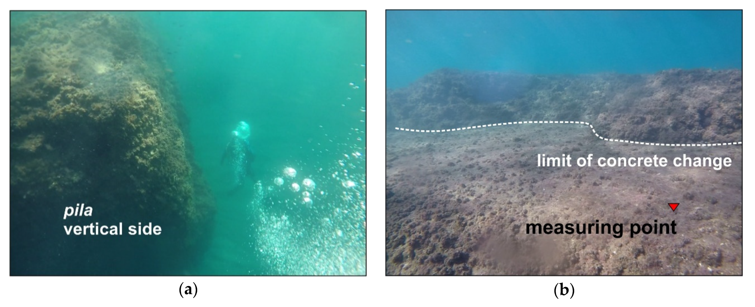
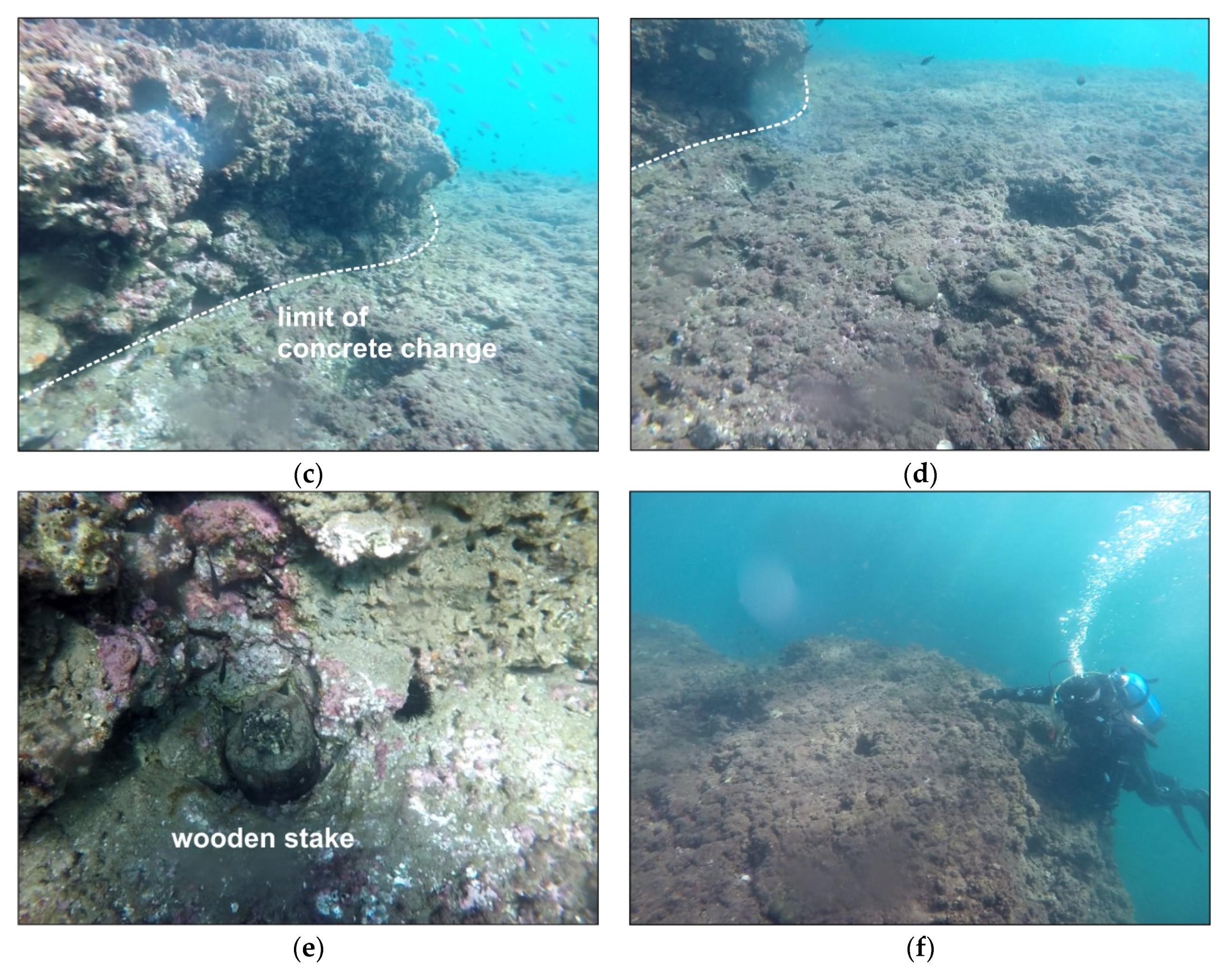
5.3. Pilae of Portus Julius (37 BCE)

During the same survey, the Roman fish tank of Portus Julius and the five pilae located at the entry of the main channel were analyzed. The pilae are coeval with the entry channel, and belong to the first construction phase of the military harbour precisely dated at 37 BCE.
The submersion value of the concrete change limit in the better-preserved pila has been determined (Figure 12), according to Mattei et al. [16]. The submersion measurement of the concrete change limit is currently located at −2.6 m MSL, and by correcting this measurement by using Equation (2) a SLIP (RSL) is determined at −3.1 m MSL.
All the submersion measurements carried out in this study were analyzed to evaluate the RSL changes that occurred between the first century BCE and the first half of the first century CE (Table 1).

6. Discussion

The results achieved in terms of the RSL variations allowed us to reconstruct the evolution of the coastal sector over the last 2100 years.
According to the narrations of Strabo [32], it is possible to affirm that, at the end of the Republican Age, the study area was shaped as by a low coastal sector located next to a sandy spit, above which, the former Via Herculanea was constructed. At that time, the littoral was characterized by shallow water and the Lucrino Gulf was not deep enough to permit navigation. For this reason, it was intended for oyster farming.
The maritime villa, analyzed in this paper, was located near to the above-mentioned spit in a flat area at a depth of about −3.5 m MSL. Therefore, considering its functional clearance, an RSL at −4.70/−5.2 m MSL can be presumed for that period.
The second evolutionary phase of the area can be posed right before 37 BCE, when the coastal sector was chosen by Agrippa for the construction of a new military harbour system and the access channel to the Lucrino Lake was enlarged and fortified. During this period, the older warehouses were still used for the supply of raw materials for the troops. The relative sea level at −3.2 m MSL measured from the pilae demonstrates that some subsidence had already occurred when the military port was built in 37 BCE. As well, we can suppose that the subsidence, which produced an increase in the water depth, encouraged the construction of the harbour facility (Figure 11).
The standing of the RSL from the fish tank at about −3.2 m MSL, even after 12 BCE, demonstrates that the area experienced a period of volcano-tectonic stability (Figure 13).
Until now, several authors have assumed that the military port was abandoned due to subsidence [28,93] but the results of our study support the idea that the most of subsidence occurred before the port was built.
Coming to more recent times, around the year 500 CE, it is well known that the area was affected by a new and stronger phase of subsidence which led to an RSL up to +7.00 m MSL (Morhange et al. [25] and reference therein). This is also supported by the boreholes carried out by Welter-Schultes and Richling [94], claiming that, in the Middle Ages, the Averno Lake became a completely marine environment, with the lithodome holes located at a height of +7.00 m MSL on the marble columns of the Serapeo in Pozzuoli [25,33,65].
Moreover, by comparing our measurements with the Glacio-Hydro-Isostatic Adjustment (GIA) models proposed by several authors [95,96], it is possible to determine that the only contribution of the vertical ground movements (VGMs) occurred between the early first century BCE and the early first century CE. In this period, the GIA produced an SL variation in our study area of a centimetric amount (from −1.05 to −1.09 m MSL). Consequently, at the same time and in terms of VGMs, the study area suffered a subsidence of about 4.00 meters, and experienced a rapid increase (bradyseismic crisis) of another 2.00 m before 37 BCE.
By extending the geoarchaeological observations to the entire Gulf of Pozzuoli, it is interesting to compare the results obtained in the area of PJ with those of the Baia-Miseno sector studied by Aucelli et al. [97]. Along that costal sector, the authors recognized a period of volcano-tectonic stability that occurred between 60 BCE and the early years of the first century CE. This trend was testified by a stable RSL at −4 ± 0.2 m MSL, as deduced by studying three Roman fish tanks dotted along the coastline. Additionally, by comparing the RSL data with the eustatic models [95,96], the authors evaluated in an overall subsidence of 3 m for the VGMs that affected the coastal area in the last 2000 years.
Consequently, during the time span ranging between the first century BCE and the beginning of the first century CE, the NE sector (Portus Julius) and the SW sector (Baia-Miseno) of Pozzuoli Gulf showed different behaviors. Both sectors went through a period of tectonic volcano stability between the mid-late first century BCE and the beginning of the first century CE; however, the overall subsidence that followed up to the current state, was 2 m in the NE sector and about 3 m in the SW sector (Figure 12).
Concerning the beginning of the detected VGMs stability, the data on Portus Julius led us to suppose that it started before 37 BCE, when the Port was designed and built. A better constraint is available in the SW sector, were the fish tank of Hortensius Hortalus demonstrates that this stability was already set around 60 BCE (Figure 14).

7. Concluding Remarks

In this study, two different RSLs related to the same study area were recognized using archaeological sea-level markers related to different construction phases of Portus Julius.
The ancient RSL of −3.20 m, determined from the fish tank and the pilae, is related to the time between the construction of the military port (pilae) in 37 BCE and its conversion into a commercial hub (fish tank) at the end of the first century BCE (after 12 BCE). The result is innovative as all the studies carried out in the area before always proposed RSLs for the same period ranging between −6.00 m and −10 m MSL [25,26,27,34] and none had measured high-precision sea-level markers.
On the other hand, in this study, a relative sea level during the first half of the first century BCE of about −4.70/−5.20 m MSL was evaluated using the submersion measurements of the ground floor pavements of an ancient villa in the same area, well-dated, thanks to the mosaics covering the floors. Consequently, a subsidence of metric entity and volcano-tectonic nature has been deduced from the comparison between the submersion measurements of the floors of the Late Republican villa and the most recent (37 BCE) pilae of the military port. Furthermore, the high precision measurements of the fish tank (built after 12 BCE) lead us to suppose that this subsiding trend stopped before the construction of the military port, and that the area experienced a period of volcano-tectonic stability at least until the first century CE.
A further result of this work is related to the use of port structures in hydraulic concrete as SLIPs. Until now, the fish tanks were the only highly accurate archaeological indicators for sea-level reconstruction [74,75,76,77,78,98,99]. In this paper, we demonstrated that it is also possible to use port facilities as high precision markers, as long as the concrete change is recognizable. To be acceptable, this indicator must meet the following requirements:
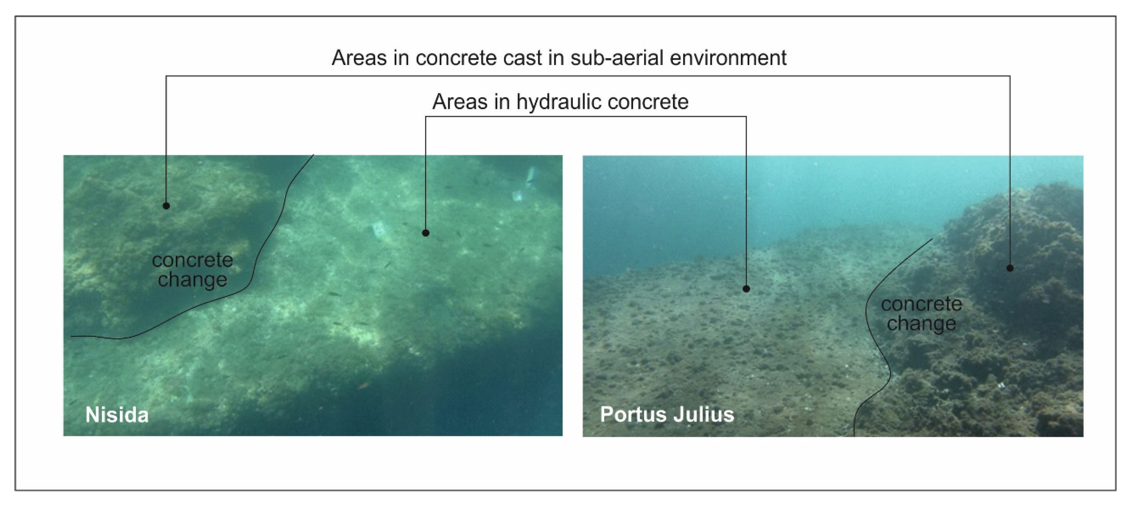
  • A visible horizontal and flat surface (concrete change limit), which is detached from the upper planes;
  • The surface (concrete change limit) must have an extension equal to at least 20% of the total upper face of the pila;
  • The surface (concrete change limit) must be harder and more compact than that of the upper layers and must be free or almost free of cover vegetation, while the upper layers must be rough with vegetation.
In conclusion, it can be affirmed that the roman pilae, when showing the above-mentioned characteristics, represent a new SLIP of great importance considering their dissemination across all of the Mediterranean Sea.

Author Contributions

Conceptualization, P.P.C.A., A.C., G.M., G.P., M.S., S.T.; methodology, P.P.C.A., G.M., C.C., A.C., F.P., S.T.; software, C.C., G.M., F.P., S.T.; validation, P.P.C.A., A.C., G.M., G.P., M.S., S.T.; investigation, C.C. and F.P.; data curation, P.P.C.A., C.C., G.M., F.P., S.T.; writing—original draft preparation, C.C., A.C., G.M., M.S.; writing—review and editing, P.P.C.A., C.C., A.C., G.M., G.P., M.S., S.T. All authors have read and agreed to the published version of the manuscript.

Funding

This research was financially supported by research found of Parthenope University granted to Pietro P.C. Aucelli and Gerardo Pappone.

Acknowledgments

The authors extend their sincere thanks to Francesco Salvatore Ruggiero and Gennaro Sorrentino of Meno 100 Underwater TEK ASD for their willingness and their important support during the diving surveys. The coastal LIDAR data used in this paper were kindly provided by the Ministry of the Environment in March 2013.

Conflicts of Interest

The authors declare no conflict of interest.

References

  1. Derbyshire, E.; Hails, J.R.; Gregory, K.J. Geomorphological Processes: Studies in Physical Geography; Butterworth-Heinemann: London, UK, 1979. [Google Scholar]
  2. Eybergen, F.A.; Imeson, A.C. Geomorphological processes and climatic change. Catena 1989, 16, 307–319. [Google Scholar] [CrossRef]
  3. Alberico, I.; Amato, V.; Aucelli, P.P.C.; Di Paola, G.; Pappone, G.; Rosskopf, C.M. Historical and recent changes of the Sele River coastal plain (Southern Italy): Natural variations and human pressures. Rend. Lincei 2012, 23, 3–12. [Google Scholar] [CrossRef]
  4. Pappone, G.; Aucelli, P.P.C.; Alberico, I.; Amato, V.; Antonioli, F.; Cesarano, M.; Di Paola, G.; Pelosi, N. Relative sea-level rise and marine erosion and inundation in the Sele river coastal plain (Southern Italy): Scenarios for the next century. Rend. Lincei 2012, 23, 121–129. [Google Scholar] [CrossRef]
  5. Antonioli, F.; Ferranti, L.; Fontana, A.; Amorosi, A.; Bondesan, A.; Braitenberg, C.; Dutton, A.; Fontolan, G.; Furlani, S.; Lambeck, K.; et al. Holocene relative sea-level changes and vertical movements along the Italian and Istrian coastlines. Quat. Int. 2009, 206, 102–133. [Google Scholar] [CrossRef]
  6. Cinque, A.; Irollo, G.; Romano, P.; Ruello, M.R.; Amato, L.; Giampaola, D. Ground movements and sea levelchanges in urban areas: 5000 years of geological and archaeological record from Naples (Southern Italy). Quat. Int. 2011, 232, 45–55. [Google Scholar] [CrossRef]
  7. Aucelli, P.; Cinque, A.; Mattei, G.; Pappone, G. Historical sea level changes and effects on the coasts of Sorrento Peninsula (Gulf of Naples): New constrains from recent geoarchaeological investigations. Palaeogeogr. Palaeoclimatol. Palaeoecol. 2016, 463, 112–125. [Google Scholar] [CrossRef]
  8. Aucelli, P.; Cinque, A.; Giordano, F.; Mattei, G. A geoarchaeological survey of the marine extension of the Roman archaeological site Villa del Pezzolo, Vico Equense, on the Sorrento Peninsula, Italy. Geoarchaeology 2016, 31, 244–252. [Google Scholar] [CrossRef]
  9. Aucelli, P.; Cinque, A.; Mattei, G.; Pappone, G. Late Holocene landscape evolution of the gulf of Naples (Italy) inferred from geoarchaeological data. J. Maps 2017, 13, 300–310. [Google Scholar] [CrossRef] [Green Version]
  10. Aucelli, P.P.C.; Cinque, A.; Mattei, G.; Pappone, G.; Stefanile, M. Coastal landscape evolution of Naples (Southern Italy) since the Roman period from archaeological and geomorphological data at Palazzo degli Spiriti site. Quat. Int. 2018, 483, 23–38. [Google Scholar] [CrossRef]
  11. Aucelli, P.P.C.; Cinque, A.; Mattei, G.; Pappone, G.; Stefanile, M. First results on the coastal changes related to local sea level variations along the Puteoli sector (Campi Flegrei, Italy) during the historical times. Alp. Mediterr. Quat. 2018, 31, 13–16. [Google Scholar]
  12. Aucelli, P.P.C.; Cinque, A.; Mattei, G.; Pappone, G.; Rizzo, A. Studying relative sea level change and correlative adaptation of coastal structures on submerged Roman time ruins nearby Naples (southern Italy). Quat. Int. 2019, 501, 328–348. [Google Scholar] [CrossRef]
  13. Rovere, A.; Raymo, M.E.; Vacchi, M.; Lorscheid, T.; Stocchi, P.; Gómez-Pujol, L.; Harris, D.L.; Casella, E.; O’Leary, M.J.; Hearty, P.J. The analysis of the Last Interglacial (MIS 5e) relative sea-level indicators: Reconstructing sea-level in a warmer world. Earth Sci. Rev. 2016, 159, 404–427. [Google Scholar] [CrossRef] [Green Version]
  14. Vacchi, M.; Marriner, N.; Morhange, C.; Spada, G.; Fontana, A.; Rovere, A. Multiproxy assessment of Holocene relative sea-level changes in the western Mediterranean: Sea-level variability and improvements in the definition of the isostatic signal. Earth Sci. Rev. 2016, 155, 172–197. [Google Scholar] [CrossRef] [Green Version]
  15. Benjamin, J.; Rovere, A.; Fontana, A.; Furlani, S.; Vacchi, M.; Inglis, R.H.; Galili, E.; Antonioli, F.; Sivan, D.; Miko, S.; et al. Late Quaternary sea-level changes and early human societies in the central and eastern Mediterranean Basin: An interdisciplinary review. Quat. Int. 2017, 449, 29–57. [Google Scholar] [CrossRef] [Green Version]
  16. Mattei, G.; Troisi, S.; Aucelli, P.P.C.; Pappone, G.; Peluso, F.; Stefanile, M. Sensing the Submerged Landscape of Nisida Roman Harbour in the Gulf of Naples from Integrated Measurements on a USV. Water 2018, 10, 1686. [Google Scholar] [CrossRef] [Green Version]
  17. De Giosa, F.; Scardino, G.; Vacchi, M.; Piscitelli, A.; Milella, M.; Ciccolella, A.; Mastronuzzi, G. Geomorphological Signature of Late Pleistocene Sea Level Oscillations in Torre Guaceto Marine Protected Area (Adriatic Sea, SE Italy). Water 2019, 11, 2409. [Google Scholar] [CrossRef] [Green Version]
  18. Khan, N.S.; Horton, B.P.; Engelhart, S.; Rovere, A.; Vacchi, M.; Ashe, E.L.; Törnqvist, T.E.; Dutton, A.; Hijma, M.P.; Shennan, I. Inception of a global atlas of sea levels since the Last Glacial Maximum. Quat. Sci. Rev. 2019, 220, 359–371. [Google Scholar] [CrossRef]
  19. Kolaiti, E.; Mourtzas, N.; Kissas, K.; Antonioli, F.; Lambeck, K. New insights into the uplifted Roman harbour at Mavra Litharia (N Peloponnese, Greece) in the geodynamic context of the southern margin of the Corinth Gulf. Quat. Int. 2019, 508, 23–35. [Google Scholar] [CrossRef]
  20. Vacchi, M.; Russo Ermolli, E.; Morhange, C.; Ruello, M.; Di Donato, V.; Di Vito, M.; Giampaola, D.; Carsana, V.; Liuzza, V.; Cinque, A.; et al. Millennial variability of rates of sea-level rise in the ancient harbour of Naples (Italy, western Mediterranean Sea). Quat. Res. 2019, 1–15. [Google Scholar] [CrossRef]
  21. Dvorak, J.J.; Mastrolorenzo, G. The Mechanisms of Recent Vertical Crustal Movements in Campi Flegrei Caldera, Southern Italy; The Geological Society of America Spec. Pap.: Boulder, CO, USA, 1991; Volume 263, p. 49. [Google Scholar]
  22. Cinque, A.; Aucelli, P.P.C.; Brancaccio, L.; Mele, R.; Milia, A.; Robustelli, G.; Romano, P.; Russo, F.; Santangelo, N.; Sgambati, D. Volcanism, tectonics and recent geomorphological change in the bay of Napoli. Suppl. Geogr. Fis. Din. Quat. 1997, 3, 123–141. [Google Scholar]
  23. Morhange, C.; Bourcier, M.; Laborel, J.; Giallanella, C.; Goiran, J.P.; Crimaco, L.; Vecchi, L. New data on historical relative sea level movements in Pozzuoli, Phlegrean Fields, southern Italy. Phys. Chem. Earth 1999, 24, 349–354. [Google Scholar] [CrossRef]
  24. Morhange, C.; Blanc, F.; Schmitt-Mercury, S.; Bourcier, M.; Carbonel, P.; Oberlin, C.; Prone, A.; Vivent, D.; Hesnard, A. Stratigraphy of late-Holocene deposits of the ancient harbour of Marseilles, southern France. Holocene 2003, 13, 539–604. [Google Scholar] [CrossRef]
  25. Morhange, C.; Marriner, N.; Laborel, J.; Todesco, M.; Oberlin, C. Rapid sea-level movements and non-eruptive crustal deformation in the phlegrean Fields caldera, Italy. Geology 2006, 34, 93–96. [Google Scholar] [CrossRef]
  26. Bellucci, F.; Woo, J.; Kilburn, C.R.; Rolandi, G. Ground deformation at Campi Flegrei, Italy: Implications for hazard assessment. Geol. Soc. Lond. Spec. Publ. 2006, 269, 141–157. [Google Scholar] [CrossRef]
  27. Passaro, S.; Barra, M.; Saggiorno, R.; Di Giacomo, S.; Leotta, A.; Uhlen, H.; Mazzola, S. Multi-resolution morpho-bathymetric survey results at the Pozzuoli-Baia underwater archaeological site (Naples, Italy). J. Archaeol. Sci. 2013, 40, 1268–1278. [Google Scholar] [CrossRef]
  28. Todesco, M.; Costa, A.; Comastri, A.; Colleoni, F.; Spada, G.; Quareni, F. Vertical ground displacement at Campi Flegrei (Italy) in the fifth century: Rapid subsidence driven by pore pressure drop. Geophys. Res. Lett. 2014, 41, 1471–1478. [Google Scholar] [CrossRef] [Green Version]
  29. Sommella, P. Forma e urbanistica di Pozzuoli Romana. In Puteoli, Studi di Storia Antica Vol. II; Azienda Autonoma di Soggiorno, Cura e Turismo: Pozzuoli, Italy, 1980. [Google Scholar]
  30. Camodeca, G. Puteoli porto annonario e il commercio del grano in età imperiale. Publ. École Fr. Rome 1994, 196, 103–128. [Google Scholar]
  31. Camodeca, G. Puteoli Romana: Istituzioni e Società; UniorPress: Napoli, Italy, 2018. [Google Scholar]
  32. Strabone. Geografia V; 23 CE. [Google Scholar]
  33. Parascandola, A. I Fenomeni Bradisismici del Serapeo di Pozzuoli, Napoli; Guida: Napoli, Italy, 1947. [Google Scholar]
  34. Pappalardo, U.; Russo, F. Il Bradisismo dei Campi Flegrei (Campania): Dati Geomorfologici ed Evidenze Archeologiche. In Forma Maris, Atti Della Rassegna Internazionale di Archeologia Subacquea (Pozzuoli 1998); Gianfrotta, P.A., Maniscalco, F., Eds.; Massa Editore: Pozzuoli, Italy, 2001. [Google Scholar]
  35. Gianfrotta, P.A. I porti dell’area flegrea. Pt. Approdi Rotte Mediterr. Antico Studi Filol. Lett. 1998, 4, 155–168. [Google Scholar]
  36. Benini, A. Storia, Archeologia e Tutela dei Beni Archeologici Sommersi: L’esempio dei Campi Flegrei; Edipuglia: Bari, Italy, 2004; pp. 35–43. [Google Scholar]
  37. Benini, A.; Giacobelli, M. Peschiera o Pescheria? Curiosità flegree. In Proceedings of the Atti del III Convegno di Archeologia Subacquea, Manfredonia, Italy, 4–6 October 2007. [Google Scholar]
  38. Miniero, P. Baia sommersa e portus Iulius. Il rilievo con strumentazione integrata Multibeam. In Ricoveri Per Navi Militari Nei Porti del Mediterraneo Antico e Medievale; Blackman, D.J., Lentini, M.C., Eds.; Edipuglia: Bari, Italy, 2010; pp. 101–108. [Google Scholar]
  39. Gianfrotta, P.A. Ricerche nell’area sommersa del “Portus Iulius” (1988-’90 e successive): Un riepilogo. Atlante Temat. Topogr. Antica 2012, 22, 1–20. [Google Scholar]
  40. Mattei, G.; Rizzo, A.; Anfuso, G.; Aucelli, P.P.C.; Gracia, F.J. A tool for evaluating the archaeological heritage vulnerability to coastal processes: The case study of Naples Gulf (southern Italy). Ocean Coast. Manag. 2019, 179, 104876. [Google Scholar] [CrossRef]
  41. Mattei, G.; Rizzo, A.; Anfuso, G.; Aucelli, P.P.C.; Gracia, F.J. Enhancing the protection of archaeological sites as an integrated coastal management strategy: The case of the Posillipo Hill (Naples, Italy). Rend. Lincei Sci. Fis. Nat. 2020. [Google Scholar] [CrossRef]
  42. Caputo, M.; Pieri, L. Eustatic variation in the last 2000 years in the Mediterranean. J. Geophys. Res. 1976, 81, 5787–5790. [Google Scholar] [CrossRef]
  43. Flemming, N.C. Archaeological Evidence for Eustatic Change of Sea Level and Earth Movements in the Western Mediterranean during the Last 2000 Years; The Geological Society of America: Boulder, CO, USA, 1969. [Google Scholar]
  44. Pirazzoli, P.A. Sea level variations in the northwest Mediterranean during Roman times. Science 1976, 194, 519–521. [Google Scholar] [CrossRef] [PubMed]
  45. Antonioli, F.; Anzidei, M.; Auriemma, R.; Gaddi, D.; Furlani, S.; Lambeck, K.; Orrù, P.; Solinas, E.; Gaspari, A.; Karinja, S.; et al. Sea level change during Holocene from Sardinia and northeastern Adriatic (Central Mediterranean sea) from archaeological and geomorphological data. Quat. Sci. Rev. 2007, 26, 2463–2486. [Google Scholar] [CrossRef]
  46. Lambeck, K.; Woodroffe, C.D.; Antonioli, F.; Anzidei, M.; Gehrels, W.R.; Laborel, J.; Wright, A.J. Paleoenvironmental Records, Geophysical Modeling, and Reconstruction of Sea-Level Trends and Variability on Centennial and Longer Timescales. In Understanding Sea-Level Rise and Variability; Wiley-Blackwel: Chichester, UK, 2010. [Google Scholar]
  47. Morhange, C.; Marriner, N.; Excoffon, P.; Bonnet, S.; El-amouri, M.; Zibrowius, H. Relative sea level changes during Roman times in the NW Mediterranean. The first century Ad fish tank of Forum Julii (Fréjus, France). Geoarchaeology 2013, 28, 363–372. [Google Scholar] [CrossRef]
  48. Anzidei, M.; Lambeck, K.; Antonioli, F.; Furlani, S.; Mastronuzzi, G.; Serpelloni, E.; Vannucci, G. Coastal structure, sea-level changes and vertical motion of the land in the Mediterranean. In Sedimentary Coastal Zones from High to Low Latitudes: Similarities and Differences. Special Publications 388; Martini, I.P., Ed.; The Geological Society: London, UK, 2014. [Google Scholar] [CrossRef]
  49. D’Argenio, A.; Pescatore, T.; Senatore, M.R. Sea-level change and volcano-tectonic interplay. The Gulf of Pozzuoli (Campi Flegrei, Eastern Tyrrhenian Sea) during the last 39 ka. J. Volcanol. Geotherm. Res. 2004, 133, 105–121. [Google Scholar]
  50. De Pippo, T.; Donadio, C.; Pennetta, M.; Terlizzi, F.; Vecchione, C.; Vegliante, M. Seabed morphology and pollution along the Bagnoli coast (Naples, Italy): A hypothesis for environmental restoration. Mar. Ecol. 2002, 23, 154–168. [Google Scholar] [CrossRef]
  51. Somma, R.; Iuliano, S.; Matano, F.; Molisso, F.; Passaro, S.; Sacchi, M.; Troise, C.; De Natale, G. High-resolution morpho-bathymetry of Pozzuoli Bay, southern Italy. J. Maps 2016, 12, 222–230. [Google Scholar] [CrossRef]
  52. Isaia, R.; Vitale, S.; Marturano, A.; Aiello, G.; Barra, D.; Ciarcia, S.; Iannuzzi, E.; Tramparulo, F. High-resolution geological investigations to reconstruct the long-term ground movements in the last 15 kyr at Campi Flegrei caldera (southern Italy). J. Volcanol. Geotherm. Res. 2019, 385, 143–158. [Google Scholar] [CrossRef]
  53. Rosi, M.; Sbrana, A.; Principe, C. The Phlegraean Fields: Structural evolution, volcanic history and eruptive mechanisms. J. Volcanol. Geotherm. Res. 1983, 17, 273–288. [Google Scholar] [CrossRef]
  54. Rosi, M.; Sbrana, A. Carta Geologica e Gravimetrica dei Campi Flegrei; Consiglio Nazionale Delle Ricerche: Rome, Italy, 1986. [Google Scholar]
  55. Isaia, R.; Iannuzzi, E.; Sbrana, A.; Marianelli, P. Note Illustrative Della Carta Geologica d’Italia Alla Scala 1: 50.000; Foglio 446-477 Napoli (aree emerse); Regione Campania: Napoli, Italy, 2016. [Google Scholar]
  56. Giaccio, B.; Isaia, R.; Fedele, F.; Di Canzio, E.; Hoffecker, J.; Ronchitelli, A.; Sinitsyn, A.; Anikovich, M.; Lisitsyn, S.; Popov, V. The Campanian Ignimbrite and Codola tephra layers: Two temporal/stratigraphic markers for the Early Upper Palaeolithic in southern Italy and eastern Europe. J. Volcanol. Geotherm. Res. 2008, 177, 208–226. [Google Scholar] [CrossRef] [Green Version]
  57. Costa, A.; Folch, A.; Macedonio, G.; Giaccio, B.; Isaia, R.; Smith, V. Quantifying volcanic ash dispersal and impact of the Campanian Ignimbrite super-eruption. Geophys. Res. Lett. 2012, 39, L10310. [Google Scholar] [CrossRef] [Green Version]
  58. Albert, P.G.; Giaccio, B.; Isaia, R.; Costa, A.; Niespolo, E.M.; Nomade, S.; Pereira, A.; Renne, P.R.; Hinchliffe, A.; Mark, D.F.; et al. Evidence for a large-magnitude eruption from Campi Flegrei caldera (Italy) at 29 ka. Geology 2019, 47, 595–599. [Google Scholar] [CrossRef] [Green Version]
  59. Orsi, G.; D’Antonio, M.; de Vita, S.; Gallo, G. The Neapolitan Yellow Tuff, a large-magnitude trachytic phreatoplinian eruption: Eruptive dynamics, magma withdrawal and caldera collapse. J. Volcanol. Geotherm. Res. 1992, 53, 275–287. [Google Scholar] [CrossRef]
  60. Deino, A.L.; Orsi, G.; Piochi, M.; de Vita, S. The age of the Neapolitan Yellow Tuff caldera-forming eruption (Campi Flegrei caldera – Italy) assessed by 40Ar/39Ar dating method. J. Volcanol. Geotherm. Res. 2004, 185, 48–56. [Google Scholar] [CrossRef]
  61. Di Vito, M.A.; Isaia, R.; Orsi, G.; Southon, J.; de Vita, S.; D’Antonio, M.; Pappalardo, L.; Piochi, M. Volcanism and deformation in the past 12 ka at the Campi Flegrei caldera (Italy). J. Volcanol. Geotherm. Res. 1999, 91, 221–246. [Google Scholar] [CrossRef]
  62. Smith, V.C.; Isaia, R.; Pearce, N.J.C. Tephrostratigraphy and glass compositions of post-15 kyr Campi Flegrei eruptions: Implications for eruption history and chronostratigraphic markers. Quat. Sci. Rev. 2011, 30, 3638–3660. [Google Scholar] [CrossRef]
  63. Di Vito, M.; Lirer, L.; Mastrolorenzo, G.; Rolandi, G. The 1538 Monte Nuovo eruption (Campi Flegrei, Italy). Bull. Volcanol. 1987, 49, 608–615. [Google Scholar] [CrossRef]
  64. D’Antonio, M.; Civetta, L.; Orsi, G.; Pappalardo, L.; Piochi, M.; Caradente, A.; de Vita, S.; Di Vito, M.A.; Isaia, R. The present state of the magmatic system of the Campi Flegrei caldera based on a reconstruction of its behavior in the past 12 Ka. J. Volcanol. Geotherm. Res. 1999, 91, 247–268. [Google Scholar] [CrossRef]
  65. Cinque, A.; Rolandi, G.; Zamparelli, V. L’estensione dei depositi marini olocenici nei Campi Flegrei in relazione alla vulcano-tettonica. Boll. Soc. Geol. Ital. 1985, 104, 327–348. [Google Scholar]
  66. Reddé, M. Mare Nostrum. Les Infrastructures, le Dispositif et L’histoire de la Marine Militaire Sous L’empire Romain; Ecoles Françaises d’Athènes et de Rome: Rome, Italy, 1986; Volume 260, pp. 164–171. [Google Scholar]
  67. Vitruvius. De Architectura II; 15 BCE; Volume 6, p. 1. [Google Scholar]
  68. Cassiodorus. Chronica; 519 CE. [Google Scholar]
  69. Scognamiglio, E. Aggiornamenti per la topografia di Baia sommersa. Archeol. Sub. 1997, 2, 35–45. [Google Scholar]
  70. Shennan, I.; Long, A.J.; Horton, B.P. Handbook of Sea-Level Research; John Wiley & Sons: Oxford, UK; New York, NY, USA, 2015. [Google Scholar]
  71. Varro. De Re Rustica III; 37 BCE. [Google Scholar]
  72. Columella. De Re Rustica XVII; 30 CE. [Google Scholar]
  73. Leoni, G.; Dai Pra, G. Variazioni del Livello del Mare nel Tardo Olocene, Ultimi 2500 Anni, Lungo la Costa del Lazio in Base ad Indicatori Geo-Archeologici: Interazioni fra Neotettonica, Eustatismo e Clima; ENEA, Unità Comunicazione e Informazione: Rome, Italy, 1997. [Google Scholar]
  74. Antonioli, F.; Leoni, G. Siti archeologici e loro utilizzazione quali indicatori per lo studio delle variazioni recenti del livello del mare. Quat. Ital. J. Quat. Sci. 1998, 11, 122–139. [Google Scholar]
  75. Evelpidou, N.; Pirazzoli, P.A.; Saliegec, J.F. Submerged notches and doline sediments evidence for Holocene subsidence. Cont. Shelf Res. 2011, 31, 1273–1281. [Google Scholar] [CrossRef]
  76. Lambeck, K.; Anzidei, M.; Antonioli, F.; Benini, A.; Verrubbi, V. Tyrrhenian sea level at 2000 BP: Evidence from Roman age fish tanks and their geological calibration. Rend. Lincei 2018, 29, 69–80. [Google Scholar] [CrossRef]
  77. Auriemma, R.; Solinas, E. Archaeological remains as sea level change markers: A review. Quat. Int. 2009, 206, 134–146. [Google Scholar] [CrossRef]
  78. Lambeck, K.; Anzidei, M.; Antonioli, F.; Benini, A.; Esposito, E. Sea level in Roman time in the central Mediterranean and implications for recent change. Earth Planet. Sci. Lett. 2004, 224, 563–575. [Google Scholar] [CrossRef]
  79. Morhange, C.; Marriner, N. Archeological and biological relative sea-level indicators. Handb. Sea Level Res. 2015, 146–156. [Google Scholar] [CrossRef]
  80. Capuano, P.; Buonocore, B.; Tammaro, U.; Obrizzo, F.; La Rocca, A.; Pinto, S.; Pingue, F. Caratteristiche spettrali delle variazioni del livello marino delle baie di Napoli e Pozzuoli. ASITA Roma 2004, 1, 615–620. [Google Scholar]
  81. Stefanile, M. The Project PILAE, For an Inventory of the Submerged Roman Piers. A Preliminary Overview. Int. J. Environ. Geoinform. 2015, 2, 34–39. [Google Scholar] [CrossRef]
  82. Gianfrotta, P.A. Structures of the Augustan Age in Italy. In Caesarea Maritima, a Retrospective after Two Millennia; Raban, A., Holum, K.G., Eds.; Brill: Leiden, The Netherlands, 1996; pp. 65–76. [Google Scholar]
  83. Brandon, C.J.; Hohlfelder, R.L.; Jackson, M.D.; Oleson, J.P. Building for Eternity: The History and Technology of Roman Concrete Engineering in the Sea; Oxbow Books: Oxford/Barnsley, UK, 2014. [Google Scholar]
  84. Plinius. Naturalis Historia; 78 DC. [Google Scholar]
  85. Oleson, J.P.; Brandon, C.; Cramer, S.M.; Cucitore, R.; Gotti, E.; Hohlfelder, R.L. The ROMACONS Project: A Contribution to the Historican and Engineering Analysis of the Hydrauilc Concrete in Roman Maritime Structures. Int. J. Naut. Archaeol. 2004, 33, 199–229. [Google Scholar] [CrossRef]
  86. Scognamiglio, E. Baia sommersa: Gli sviluppi di ricerca. In Forma Maris, Atti Della Rassegna Internazionale di Archeologia Subacquea (Pozzuoli 1998); Gianfrotta, P.A., Maniscalco, F., Eds.; Massa Editore: Pozzuoli, Italy, 2001; pp. 43–50. [Google Scholar]
  87. Stefanile, M.; Mattei, G.; Troisi, S.; Aucelli, P.P.C.; Pappone, G.; Peluso, F. The Pilae of Nisida. Some geological and archaeological observations. Archaeol. Marit. Mediterr. 2018, 15, 81–100. [Google Scholar]
  88. Mattei, G.; Troisi, S.; Aucelli, P.P.C.; Pappone, G.; Peluso, F.; Stefanile, M. Multiscale reconstruction of natural and archaeological underwater landscape by optical and acoustic sensors. In Proceedings of the 2018 IEEE International Workshop on Metrology for the Sea; Learning to Measure Sea Health Parameters (MetroSea), Bari, Italy, 8–10 October 2018; pp. 46–49. [Google Scholar]
  89. Sivan, D.; Wdowinski, S.; Lambeck, K.; Galili, E.; Raban, A. Holocene sea-level changes along the Mediterranean coast of Israel, based on archaeological observations and numerical model. Palaeogeogr. Palaeoclimatol. Palaeoecol. 2001, 167, 101–117. [Google Scholar] [CrossRef]
  90. Benassai, G.; de Maio, A.; Sansone, E. Altezze e periodi delle onde significative nel Golfo di Napoli dall’aprile 1986 al giugno 1987. Ann. IUN 1994, 61, 3–9. [Google Scholar]
  91. Buonocore, B.; Sansone, E.; Zambardino, G. Rilievi ondametrici nel Golfo di Napoli. Ann. IUN 2003, 67, 203–211. [Google Scholar]
  92. Saviano, S.; Kalampokis, A.; Zambianchi, E.; Uttieri, M. A year-long assessment of wave measurements retrieved from an HF radar network in the Gulf of Naples (Tyrrhenian Sea, Western Mediterranean Sea). J. Oper. Oceanogr. 2019, 12, 1–15. [Google Scholar] [CrossRef]
  93. Maniscalco, F. Gli edifici sommersi del Palatium dei Severi a Baia: Nuovi dati per la definizione del bradisismo flegreo. In Forma Maris, Atti Della Rassegna Internazionale di Archeologia Subacquea (Pozzuoli 1998); Gianfrotta, P.A., Maniscalco, F., Eds.; Massa Editore: Pozzuoli, Italy, 2001. [Google Scholar]
  94. Welter-Dchultes, F.W.; Richling, I. Palaeoenvironmental history of the Holocene volcanic crater lake Lago d’Averno (central southern Italy) inferred from aquatic mollusc deposits. J. Quat. Sci. 2000, 15, 805–812. [Google Scholar] [CrossRef]
  95. Lambeck, K.; Antonioli, F.; Anzidei, M.; Ferranti, L.; Leoni, G.; Scicchitano, G.; Silenzi, S. Sea level change along the Italian coasts during Holocene and prediction for the future. Quat. Int. 2011, 232, 250–257. [Google Scholar] [CrossRef]
  96. Vacchi, M.; Ghilardi, M.; Melis, R.T.; Spada, G.; Giaime, M.; Marriner, N.; Lorscheid, T.; Morhange, C.; Burjachs, F.; Rovere, A. New relative sea-level insights into the isostatic history of the Western Mediterranean. Quat. Sci. Rev. 2018, 201, 396–408. [Google Scholar] [CrossRef]
  97. Aucelli, P.P.C.; Caporizzo, C.; Cinque, A.; Mattei, G.; Pappone, G.; Stefanile, M. Reconstructing the relative sea level and the palaeo-shoreline during the first century BC in the unstable Campi Flegrei caldera (S. Italy). 2020; under review. [Google Scholar]
  98. Amato, V.; Aucelli, P.P.C.; Mattei, G.; Pennetta, M.; Rizzo, A.; Rosskopf, C.M.; Schiattarella, M. A geodatabase of Late Pleistocene-Holocene palaeo sea-level markers in the Gulf of Naples. Alp. Mediterr. Quat. 2018, 31, 5–9. [Google Scholar]
  99. Pappone, G.; Aucelli, P.P.C.; Mattei, G.; Peluso, F.; Stefanile, M.; Carola, A. A Detailed Reconstruction of the Roman Landscape and the Submerged Archaeological Structure at “Castel dell’Ovo islet” (Naples, Southern Italy). Geosciences 2019, 9, 170. [Google Scholar] [CrossRef] [Green Version]
Figure 1. Geological map of the Campi Flegrei volcanic area with the chronologic classification of the main volcanic events (after Isaia et al. [52]) and the positioning of the main archaeological remains of Roman age (after Camodeca [30]).
Water 12 00658 g001
Figure 2. Archaeological map of Portus Julius (after Scognamiglio [69]) with the archaeological sea level markers used in this study highlighted with black rectangles.
Water 12 00658 g002
Figure 3. Measuring point in the Portus Julius fish tank (MHW: Mean High Water; MLW: Mean Low Water; SLIP: Sea Level Index Point).
Water 12 00658 g003
Figure 4. Measuring point in the Portus Julius pila (MHW: Mean High Water; MLW: Mean Low Water; SLIP: Sea Level Index Point).
Water 12 00658 g004
Figure 5. Comparison between the Nisida and Portus Julius pilae: the black line identifies the concrete change limit.
Water 12 00658 g005
Figure 6. Terrestrial limiting point in the villa close to Portus Julius (TPL: Terrestrial Limiting Point).
Water 12 00658 g006
Figure 7. 3D reconstruction of the photogrammetric system used during the survey.
Water 12 00658 g007
Figure 8. (a) Reconstruction of the photogrammetric system used during the survey; (b) The photogrammetric system used during the survey; (c) Position of the cameras during the survey.
Water 12 00658 g008
Figure 9. One of the opus signinum floors of the maritime villa of Republican age.
Water 12 00658 g009
Figure 10. (a) Dense cloud point of the fish tank where the two gates cutting the embankment are clearly visible; (b) Zoom of the 3D reconstruction of the well preserved gate; (c) Zoom of the 3D reconstruction of two perimeter walls of the fish tank; (d) 3D sketch of the surveyed fish tank.
Water 12 00658 g010aWater 12 00658 g010b
Figure 11. (a,b) details of the sluice gate of the fish tank still in situ; (c,d) details of the collapsed sluice gate of the fish tank.
Water 12 00658 g011
Figure 12. Underwater photos of the pilae of the Portus Julius entry channel (a) vertical slide of one of the pilae; (bd) limit of the concrete change measured during the survey on different pilae; (e) detail of the remain of a wooden stake (destina) used for the construction of the pilae; (f) measuring the concrete change submersion.
Water 12 00658 g012aWater 12 00658 g012b
Figure 13. Reconstruction of the probable coastline during the first years of the first century BCE (continuous black line) when the maritime villa was built and the coastline in 37 BCE (stretch and point black line), after the 2 m of subsidence, when the Portus Julius was built.
Water 12 00658 g013
Figure 14. Comparison between the RSL data derived from the geoarchaeological study of the Baia-Miseno sector Aucelli et al. [97] and those obtained for the Portus Julius sector.
Water 12 00658 g014
Table 1. The archaeological sea level markers and the related RSLs. Where: E = submersion measurements; fc = functional clearance; RWL = Reference Water Level (IR/2); RSL = Relative sea level.
Marker TypeAgeE (m)fc (m)RWL (m)RSL (m)Uncertainty
PiscinaTop Sluice GateI cen. CE−2.70−0.20−0.20−3.10±0.20
PilaeConcrete ChangeI cen. CE−2.60−0.30−0.20−3.10±0.20
Maritime VillaFloorI cen. BCE−3.20−1.50/−2.00-−4.70/−5.20-

