UPDATES


BACKGROUND
Today Westnedge and Park are through-streets with high speeds, wide lanes, and few places for pedestrians to comfortably cross. They often feel more like freeway lanes than city streets and do not match the adjacent neighborhood buildings and houses.
After the City was transferred control of several downtown streets in 2019, including Westnedge & Park, we held street design community meetings to discuss how these streets could be reimaged to better align with the community’s goals. At those meetings we heard from the community a desire for slower streets that better serve all users. This includes slower vehicle speeds, safer, more comfortable pedestrian and bicycle travel, robust transit, as well as alignment between streets and the adjacent land uses and buildings.
The City is partnering with planning and engineering consultants to move the design discussions, engineering review, and cost estimates work for the street network forward. This will help the City determine budget, project phasing, and timeline for all the streets. Road redesigns can take a long time to implement and because of many factors, Westnedge and Park will be the last of the three one-way pairs (Michigan Avenue, Kalamazoo Avenue, South Street, Lovell Street, Westnedge, and Park Street) to be converted to two-way traffic. These factors include the consideration of the review, approval, budgets, and timelines of multiple local, state, and federal agencies, as well as utility planning, and planning/managing interruptions to businesses and travel.
We have been looking at what projects we can start now to have an immediate improvement while long-term street design and construction planning work is underway. This project is a first step toward making Westnedge and Park better serve the adjacent residents, business, and all travelers.
OVERVIEW
This project focuses on calming traffic on Westnedge and Park between Dunkley Street (north city limit) all the way south to Crosstown Parkway, spanning across the Northside, Downtown, and Vine neighborhoods and adjacent to the Stuart neighborhood.
Our Goals through this project are to:
Reduce speeding on Westnedge and Park
Create streets that allow all users to travel safely and comfortably
Support economic vitality by removing transportation challenges
Align the streets with the adjacent character of the neighborhood (city scale, not freeway scale)
To achieve those goals, we are proposing the following actions:
Slow traffic by narrowing or reducing the number of vehicle lanes
Under the Michigan Department of Transportation (MDOT) control, Westnedge and Park were marked with overly wide travel lanes. Wider lanes are typically found on higher speed roads and expressways and when used on roadways like Westnedge and Park they promote driving at higher speeds. The City has taken over the authority on these streets, which allows us to make changes, such as lane width and the number of the vehicle lanes.
Use the extra space to add bike lanes and on-street parking
With right-sized travel lanes, there is left over space within the street (between the curbs). This space can be used to serve those traveling by bicycle and for on-street parking that will benefit adjacent commercial and residential uses. The presence of on-street parking and a bicycle lane has been shown to slow vehicle traffic. (Source)
Improve pedestrian crossings at intersections
Marked crosswalks across Westnedge and Park currently exist only at intersections with traffic lights. This leaves long stretches of each street without clear and comfortable crossing points. Working with the residents to prioritize crossing locations, the City will clearly mark pedestrian crossing points between the traffic light-controlled intersections with items such as paint and signs.
Repair sidewalks and fill in gaps in the sidewalk network
We will be reviewing the existing sidewalks in the blocks leading to and in between Westnedge and Park to plan and budget sidewalk improvements in 2022 and beyond.
Many of the traffic calming ideas may include paint and signs. These relatively inexpensive materials will allow us to adjust as we monitor their impact. This project is a first step before permanent changes which could include protected bike lanes or new traffic signals.
OBJECTIVES
Partner with residents to prioritize intersection improvements and make design decisions.
Calm traffic and improve travel for all users while the larger Street Network Update project is in the planning and budgeting phase.
Put City traffic calming goals into practice. Traffic calming and vehicle speed concerns can be reported here: https://kalamazoopublicsafety.org/traffic/
Monitor changes to determine their impacts and adjust as needed.
TIMELINE
Summer 2022
Fog Sealing from Dunkley St to Michigan Avenue
Travel Lane right-sizing and new lane configurations
Addition of buffered bike lane with on-street parking where appropriate from Dunkley St to Michigan Avenue
Pilot Bike Lane from Michigan Avenue to Maple St
July/August 2021
Outreach to properties and occupants in the area of Westnedge & Park. (Mailing Handout)
In-person, outdoor meetings in Northside, Vine, and Downtown (Events Flyer)
Virtual/Online Input Opportunity
Late August 2021: Discuss & Confirm Results of Outreach
Summer 2022: Continuing Implementation in Northside and Vine Neighborhoods
PROJECT MANAGERS:
Christina Anderson, City Planner
Dennis Randolph, Traffic Engineer
STAFFING
Community Planning & Economic Development, Public Services, Kalamazoo Department of Public Safety
PLAN ALIGNMENT
Strategic Vision, 2025 Master Plan, Neighborhood Plans, Street Design Manual
Related Strategic Vision Goals/Actions
Connected City - A City networked for walking, biking, riding, and driving.
Network Strategies: Maintain and connect roads, sidewalks, and paths to reduce vehicle miles traveled and expand connective access to neighborhood amenities.
Non-Motorized Transportation: Develop and maintain a complete network of pedestrian and bicycle infrastructure of trails, bike lanes, sidewalks, crosswalks that focuses on seamless connections between the various transit options.
Safe Community - Creating a safe environment for living, working, and playing.
Safe Transportation: Maintain the transportation network to ensure that
community members can travel between spaces safely and efficiently in any mode of transportation.
Complete Neighborhoods - Residential areas that support the full range of people’s daily needs
Land Use & Transportation: Maintain and develop a network of streets that respond to the needs of the neighborhoods by supporting future land use and transportation goals.
Economic Vitality - Growing businesses and stabilizing the local economy to the benefit of all.
Downtown & Corridor Experience: Support the development of a downtown district and vibrant commercial corridors to meet the changing needs of our
community.
Related Master Plan Goals/Actions
Street design should respond to land use and become safe for all users toward no fatalities or serious injuries involving road traffic.
Reduce the impact of traffic on Downtown streets through on-street parking, streetscaping, and traffic calming.
Complete the gaps/missing connectivity between neighborhoods throughout the city for pedestrian, bicycle, and recreational Non- Motorized Plan implementation.
Determine the physical barriers that separate neighborhoods and mitigate them to the greatest extent possible.
Make streets with high traffic volume safer for crossing.
Related Vine Neighborhood Plan Goals/Actions
Improve Sidewalk Conditions to Help Promote Greater Walkability
Slow Traffic Along Major Corridors
Improve the Neighborhood Connectivity to the Rest of Kalamazoo
Paint Crosswalks and Install Pedestrian Crossing Signs Where Added Visibility is Needed Connecting to Schools, Commercial Areas, and Parks
Install Curb Bump Outs on Westnedge in Commercial Node
Related Northside Neighborhood Plan Goals/Actions
Improve facades, infrastructure, sidewalks, and streetscaping in the District.
Locate property to install murals throughout the Northside
PUBLIC PARTICIPATION
The engagement level for this project is Collaborating because it is a project that will be led by the City, but residents will be helping to shape it through lots of back and forth to create solutions.
Community input collected during this project on priority intersections for pedestrian improvements is the primary tool for making decisions. To support the discussions and decisions, we will also have crash reports, citizen complaints, and bus stop/route information.
STRATEGIC VISION GOALS
Connected City, Complete Neighborhoods, Economic Vitality, Safe Community
METRICS
Vehicle speeds before and after improvements.
Number of vehicle-related accidents before and after improvements.
Surveys on level of comfortability in crossing Westnedge and Park, before and after improvements.
BUDGET
To be determined number and types of intersection improvements, that will be determined through community engagement.
FUNDING SOURCE
Foundation for Excellence
Sign-Up for Updates
If you would like to receive updates on this project, please enter your email address below to be added to our email list.
2022 IMPROVEMENTS
UPDATED: Monday July 11, 2022
The second phase of improvements starts Monday July 11th, 2022 with fog sealing and restriping from Dunkley to Michigan to create a uniform appearance and add bike lanes and on-street parking areas.
The streets will remain open throughout the project with single lane closures at a time as needed. The project is planned to be completed according to the following schedule. This schedule could be impacted by weather.
Monday, July 11
No Parking Notice (Dunkley to Michigan) - Signage will be placed and notice will be given to residents and businesses that on-street parking will not be available during work.
Tuesday, July 12
Removing Pavement Markings (Dunkley to Michigan) - Existing pavement markings will be removed. No lane closures but there may be delays related to crews in the roadway.
Wednesday, July 13
Fog Sealing (Dunkley to Kalamazoo) - Only one lane will be closed at a time. The outside lanes will be sealed first, followed by the inside lanes.
Thursday, July 14
Fog Sealing (Kalamazoo to Michigan) - Only one lane will be closed at a time. The outside lanes will be sealed first, followed by the inside lanes.
Adding Pavement Markings (Dunkley to Kalamazoo) - No lane closures during pavement marking but there may be delays related to crews in the roadway.
Friday, July 15
Adding Pavement Markings (Kalamazoo to Michigan) - No lane closures during pavement marking but there may be delays related to crews in the roadway.
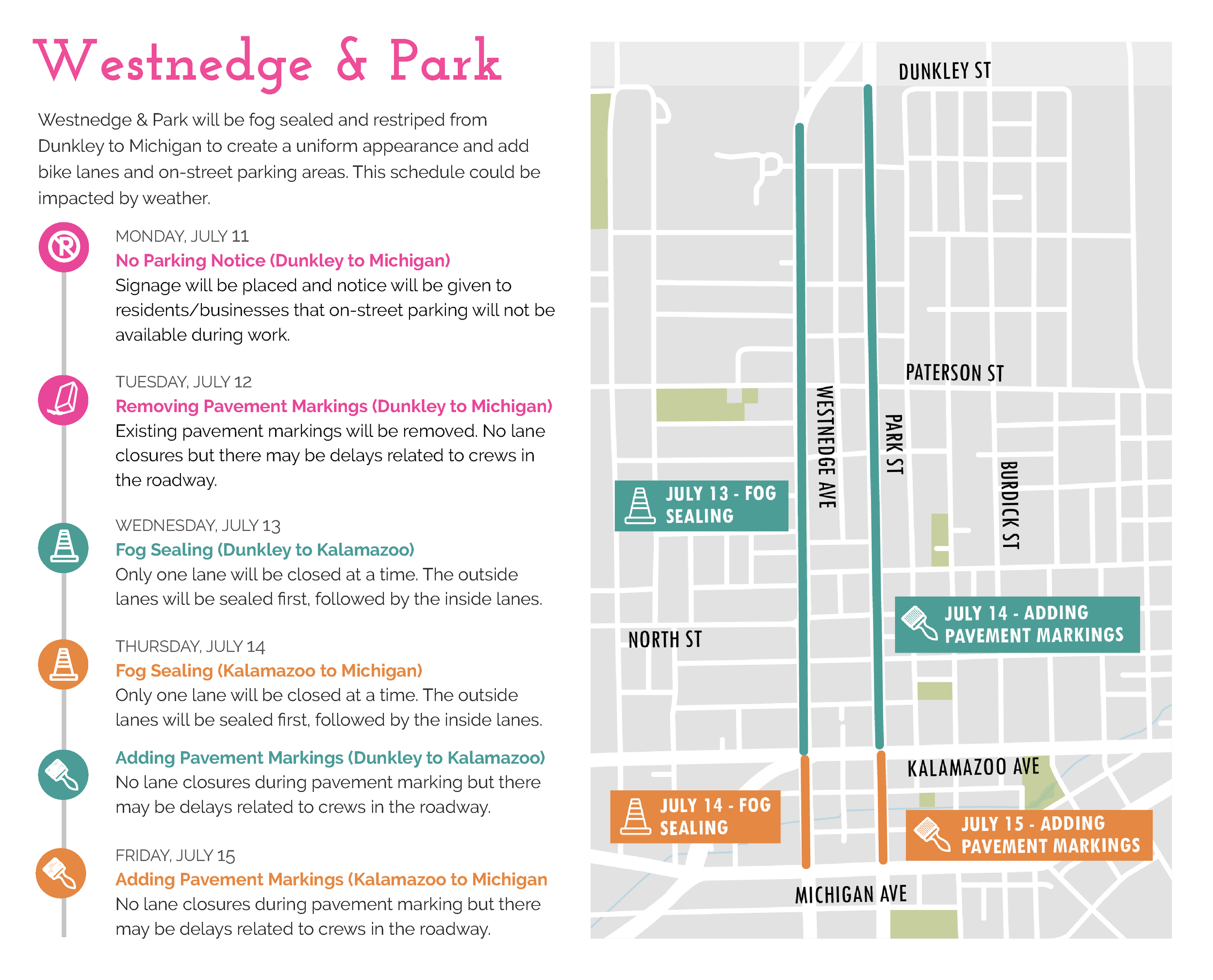
Westnedge and Park Fog Sealing Schedule
Northside Neighborhood Improvements (Dunkley St to Michigan Ave)
RE-SURFACING (FOG SEALING)
Westnedge and Park between Dunkley and Michigan will be Fog Sealed. A Fog Seal is a light coat of asphalt that is sprayed to create a to create a uniform black surface and rejuvenate the asphalt pavement. It also increases and improves the visibility of new paint and the life expectancy of a street. It requires warm weather conditions to cure and cannot be driven on to ensure it cures correctly and evenly.
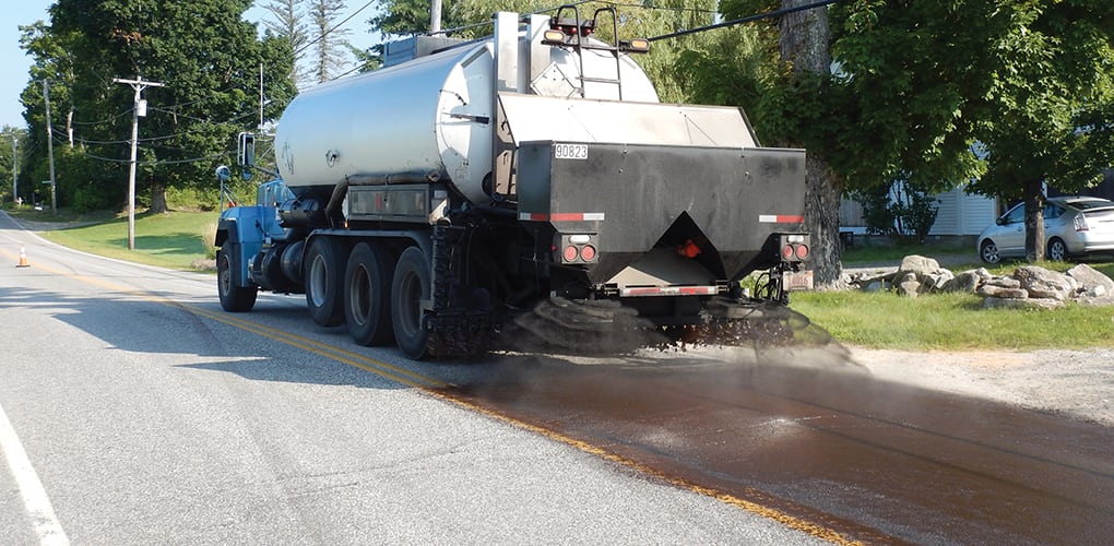
Fog Sealing Process
Photo Credit: Beta Inc.
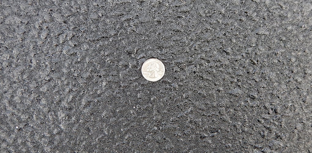
Close-up image of finished Fog seal process
Source: Photo Credit: Beta Inc.
RIGHT-SIZING TRAVEL LANES
Once the Fog Sealing process is complete, Westnedge and Park between Dunkley and Michigan will be repainted to right-sized travel lanes in 2022. This includes reducing the width of existing lanes from various sizes between 12’ and 14’ to a standard 11’ width to help calm traffic.
ON-STREET BICYCLE LANES
Once the street travel lanes are right-sized, the newfound space throughout the entire project will allow for the addition of an on-street bicycle lane in each direction (Southbound on Westnedge, Northbound on Park). This will create a much-needed north-south bike route through the City connecting neighborhoods to Downtown Kalamazoo and the Kalamazoo River Valley Trail at Kalamazoo Avenue.
The bike lanes will be added from Kalamazoo to Dunkley.
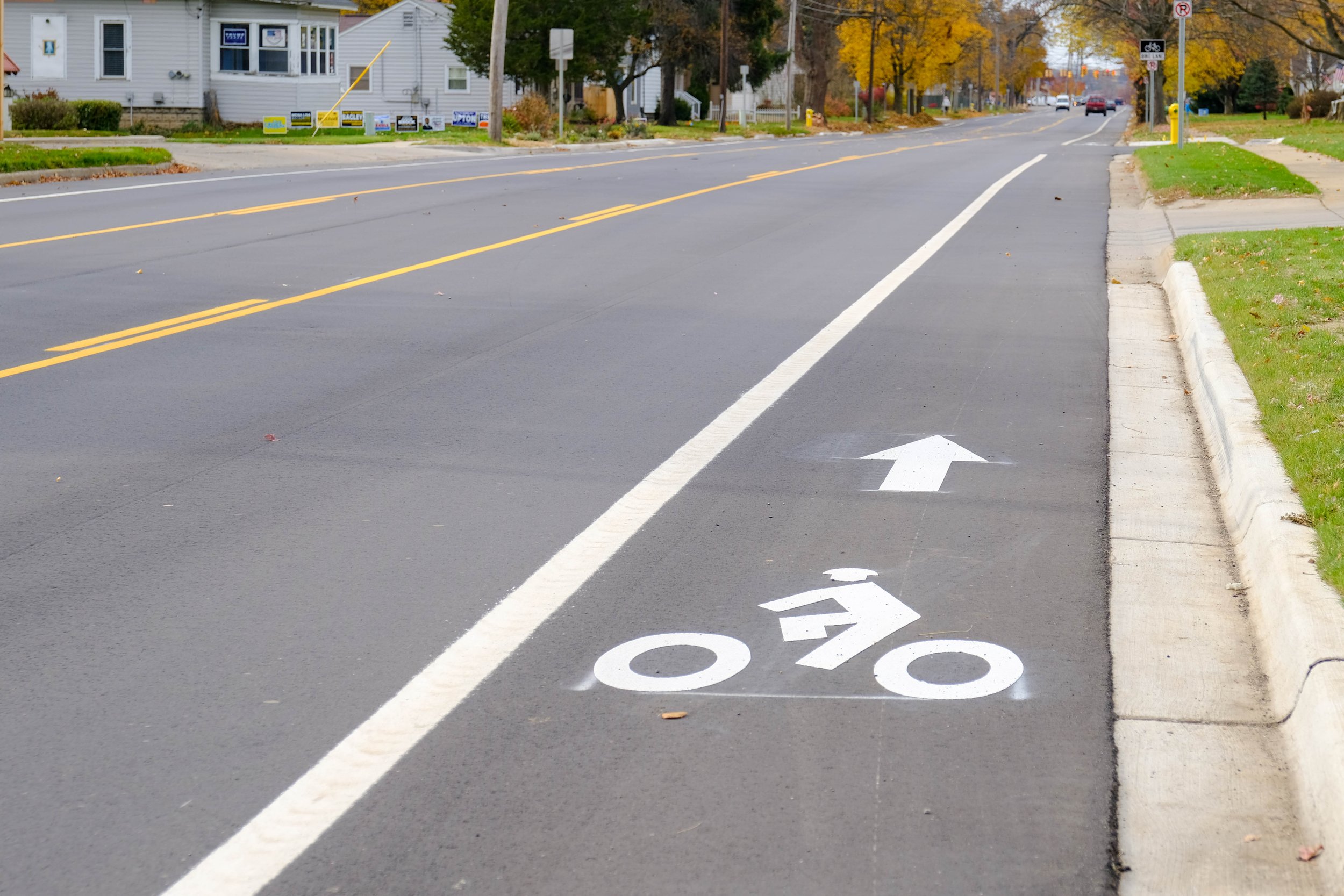
Imagine showing a conventional bike lane
ON-STREET PARKING
An additional benefit of right-sizing the travel lanes and the newfound space is the availability to add on-street parking at specific locations throughout the project. These spaces will include painted pavement markings showing where cars can park.
Vine Neighborhood Improvements (Michigan Avenue to Crosstown Parkway)

Fog Sealing will not occur from Michigan to Crosstown in 2022.
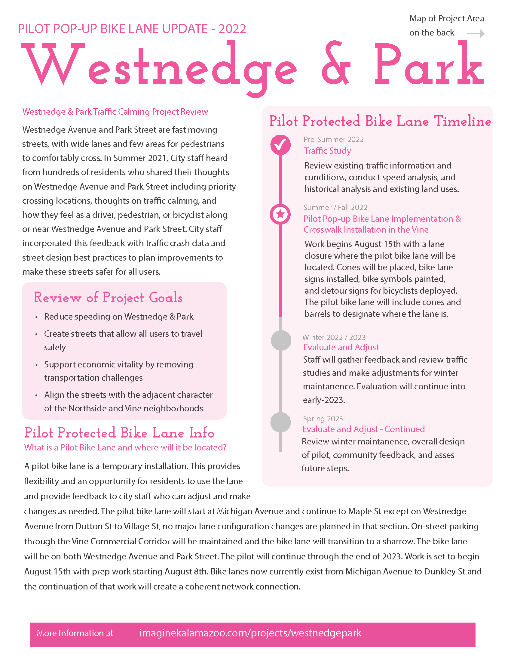
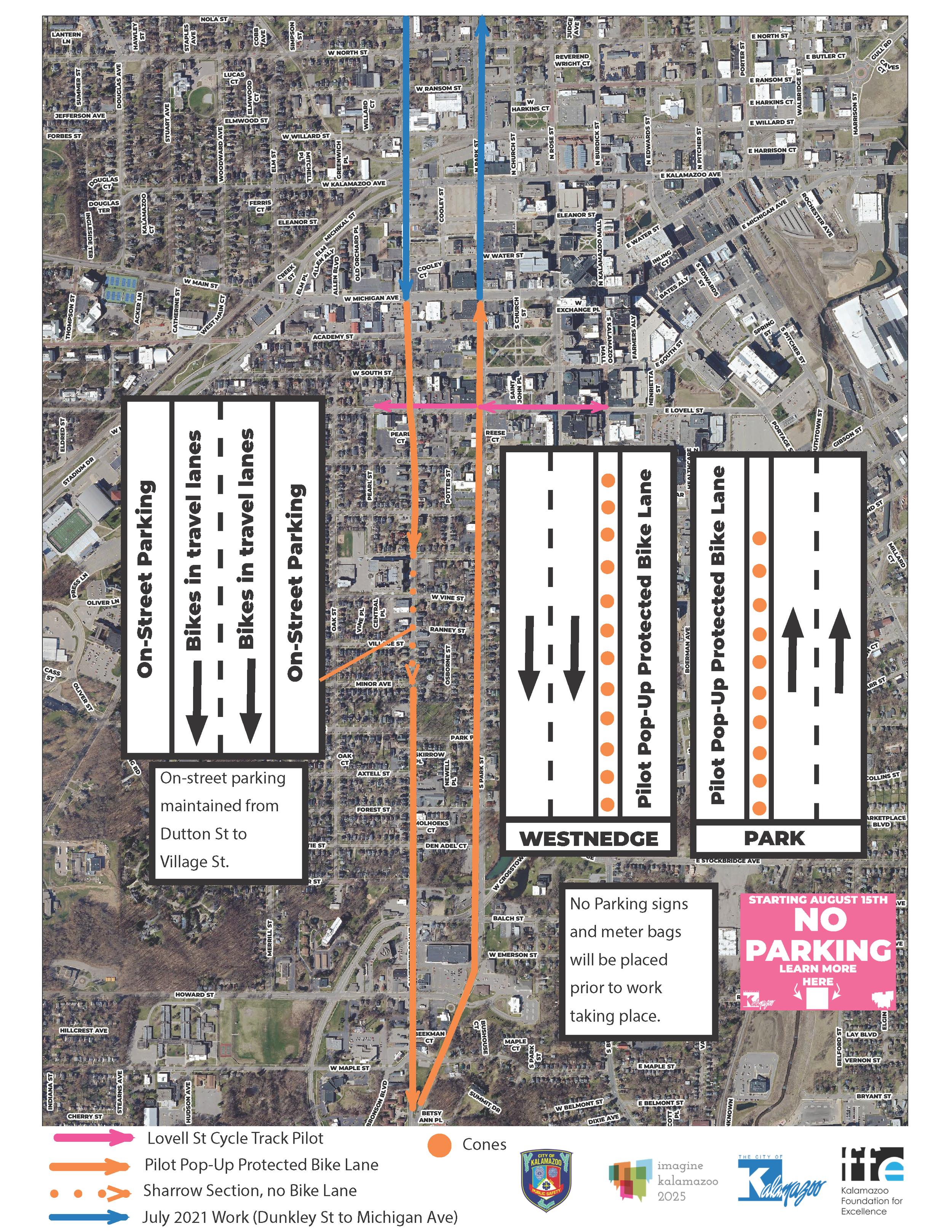
PILOT POP-UP BIKE LANE (Michigan Avenue to Maple St)
A pilot protected bike lane will be piloted using cones and barrels from Michigan Avenue to Maple St. From Dutton St to Village St the pilot bike lane will transition to shared-use markings or “sharrows” to retain on-street parking for Businesses in the Vine Commercial Corridor. The Pilot Bike lanes will then continue from Village St to Maple St.
UPDATE (November 2022)
The Pilot Bike Lanes will remain in-place into the Winter. Cones and Barrels have been replaced with painted lines and bollards at intersections. Green Bike Boxes have been added at 4 key crossing points where Westnedge and Park intersect Michigan and Kalamazoo Avenue. The streetbond used for these bike boxes is more durable than regular paint. Drone footage below shows what these new facilities look like from above.

Pop-up Pilot Bike Lane Example
Source: Vanderbilt University

Rendering Example of Shared-Use Markings or “Sharrows”
Source: NACTO
NEW CROSSWALKS & SIGNAGE
Crosswalks & Signage will be added at the following intersections to increase pedestrian access and safety across Westnedge and Park:
On Westnedge:
Walnut – new
Wheaton – new
Forest – new
On Park:
Walnut – new
Burr Oak – new
Forest – new
Intersections which currently have crosswalks and signage are:
On Westnedge:
Dutton – Existing
Vine – Existing
North of Village – Existing
Crosstown – existing
On Park:
Vine – existing
Crosstown – existing
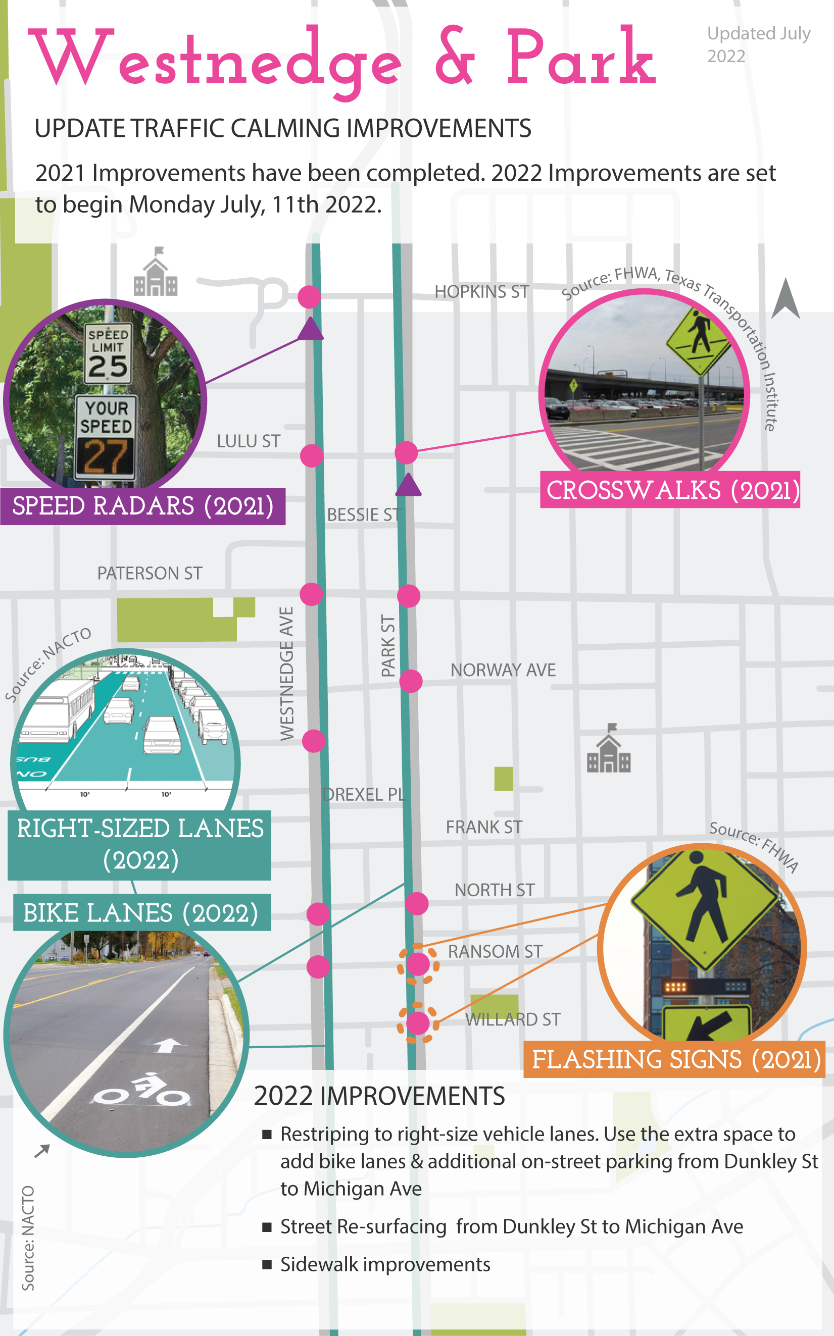
September 2021 Implementation Update
UPDATED: Friday, October 29, 2021
Throughout the month of August 2021, the City of Kalamazoo engaged residents and businesses to understand the needs and concerns of both Westnedge Avenue and Park Street between Dunkley and Crosstown. City staff incorporated this feedback with traffic crash data and best practice research in street design to plan improvements to make these streets safer for all users. Implementation will start this fall and continue into 2022.

Map of improvements planned for 2021 and 2022 on Park and Westnedge.
FALL 2021 IMPROVEMENTS
In Fall 2021, residents of the Northside Neighborhood will be the first to see changes made to support traffic calming and make both streets more comfortable for pedestrians and cyclists. These improvements include adding several new pedestrian crosswalks and ‘Your Speed Is’ radar signs.
PEDESTRIAN IMPROVEMENTS
Both Westnedge and Park disconnect the Northside Neighborhood, which forces pedestrians to only a few intersections to safely cross the street, many of which are out of the way. The City, through its engagement process, asked residents where crosswalks should be located to improve pedestrian activity, and access to nearby neighborhood assets such as schools, parks, churches and grocery stores.
The following intersections will see pedestrian improvements including continental striped crosswalks and lime green reflective signage alerting drivers that pedestrians may be present.
Westnedge at Hopkins
Westnedge at Lulu
Westnedge at Mabel
Westnedge at Ransom
Park at Norway
Park at Lulu
Park at Ransom *
Park at Willard *
[*] With the high number of pedestrians crossing Park Street at both Ransom and Willard, these crosswalks will be enhanced with push-button-activated flashing LED lighted signs.
The existing standard crosswalks at the following signalized intersections will be upgraded to ladder crosswalks:
Westnedge & Paterson
Westnedge & North
Park & Paterson
Park & North
Additional crosswalks will be added on Westnedge at Bessie and Florence, and on Park at Drexel and Hopkins in 2022 after curb ramps are installed at those intersections.
Photo Source: FHWA, Texas Transportation Institute
Bright pedestrian crossing signage will be installed on Westnedge & Park at each of the improved crosswalks along with “ladder” crosswalks. Ladder crosswalks include pavement paint with both horizontal and vertical lines. The cross streets at these intersections will receive “standard” crosswalks which include two horizontal stripes.
SPEED RADAR SIGNS
The two areas where residents expressed the greatest concern for speeding vehicles are on the northern edge of the Northside Neighborhood where both Westnedge and Park connect with the Business Loop 131 Expressway. To address these concerns, the City will install new ‘Your Speed Is’ radar signs on Westnedge south of Hopkins, and on Park south of Lulu. These signs will alert drivers of the posted speed and also collect speed data.
“Your Speed Is” radar signs will be installed on Westnedge south of Hopkins and on Park south of Lulu.
After reviewing this information do you have any thoughts on these planned improvements or additional information you would like to share? If so, please let us know by filling out the following form. You can also send an email to hello@kalamazoocity.org or call the Engagement Hotline at 269-226-6524 and leave a message with your thoughts.
August 2021 Community Input Summary & Traffic Crash Data
In July 2021 the City of Kalamazoo launched a project to engage with residents about traffic calming along Westnedge Avenue and Park Street. The goal of this project is to implement short term, immediate improvements to these streets to help improve safety and comfortability for all users while long term street design work is being planned, such as two-way conversion.
DOCUMENTS & LINKS
Project Overview & Frequently Asked Questions
August Input Opportunity Events Flyer
Outreach
Project information was shared and feedback was sought through the following outreach methods:
Project handout mailed to 2,282 addresses* including residents and property owners along or nearby Westnedge & Park (*Does not reflect returned mail)
Flyers distributed to businesses along Westnedge & Park corridors
Project information was shared through an email list of residents involved in the larger streets design process and a list of community partners/organizations related to this work
Information was included in the City’s email newsletter that includes over 2,000 contacts
Radio ads on 95.5 The Touch and WKZO, also included live broadcast at the Galilee Baptist Church engagement event
Media release was sent out to City’s media release contact list and posted to the City and Imagine Kalamazoo websites
Information was posted to the City of Kalamazoo’s and Imagine Kalamazoo’s social media channels. The City also ran a Facebook ad to increase reach for online survey opportunities.
Radio interview on WKZO and WMUK
Television interview with WOOD and WWMT
Project presentation and overview video shared online and social media to help explain the project and how to get involved.
Input Opportunities
Informed by the City’s Public Participation Plan, several options for sharing input were offered including:
Pre-Event online input opportunity to share experiences and photos
Attending an in-person event. A series of pop-up events were held in August, two in the Northside neighborhood, two in the Vine neighborhood, and two Downtown for a total of 6 in-person events.
Online survey on the Open Town Hall platform, mirroring in-person engagement opportunities.
Walking audit in person led by volunteers at an event or a self-guided walking audit submitted online
Emailing hello@kalamazoocity.org or calling and leaving a voicemail on the Engagement Hotline at 269-226-6524 were also offered as additional options for sharing input.
Prize drawings of gift cards to local businesses in addition to ice cream and coffee, were offered as incentives for participating. Below is a summary of the outreach and engagement numbers from this effort.

A summary of input from this community engagement process as well as traffic crash data are available below. This data will be used to inform intersection and traffic calming improvements for Westnedge & Park. Design recommendations based on this data will be posted to this project page in September 2021 for community review before implementation begins in Fall 2021.

Survey Data
Full list of compiled comment coming soon.

Imagine Kalamazoo addresses residents needs through the building of a framework called Connected City that works to connect neighborhoods; create inviting public places and improve human, community, and environmental health residents’ desire. The qualitative principles of a Connected City are (1) Accessible (2) Comfortable (3) Connected (4) Convenient (5) Engaging and (6) Vibrant.
Throughout the Westnedge and Park engagement, nearly 400 Kalamazoo residents shared how they felt either on or crossing these two corridors, as someone in a car, on foot, or on a bike. This information is important to establish a baseline of how we can improve both streets to ensure they are accessible, comfortable, connected, convenient, engaging, and vibrant for all users.
In A Car
The average resident had no strong feeling either way while traveling Westnedge and Park in a vehicle. Here are a few of the comments we received:
“Traffic needs to be slowed. Businesses need to be protected from cars crashing into them”
“Coming into Kalamazoo off of the 131 Expressway is scary/dangerous”
“Many people drive too fast, it’s not safe”
“Cars need to slow down”
“Wide lanes encourage people to go 10+ MPH over the speed limit through the neighborhood”
On Foot
Pedestrians overall rated the condition of traveling across Westnedge and Park as poor. This was primarily due to high speeds and lack of safe and adequate crosswalks connecting residents to businesses and other parts of the neighborhood. Here are a few of the comments we received:
“Cars seldom pay attention to pedestrians”
“Traffic drives too fast and cars don’t look for pedestrians”
“Park street is difficult to cross for my elderly parents”
“There’s no good place to cross Westnedge by the park”
“Sometimes cars will turn while people are crossing the street”
On Bike:
Respondents also rated the condition of traveling along Westnedge and Park by bicycle as poor. A lack of adequate bicycle lanes and vehicles traveling at excessive speeds deter many on bike. Here are a few of the comments we received:
“Cars are not considerate of bicycles”
“We defiantly need bike lanes”
“I have been tailgated, making it feel unsafe”
“Westnedge is scary on a bike”
Additional Comments

After analyzing several hundred comments, a few key themes on the conditions and safety of Westnedge and Park emerged as can be seen above in the Word Cloud graphic.
Speed – Most participants in the engagement process recognized that vehicles on both Westnedge and Park were speeding.
Pedestrians – Three neighborhoods, Northside, Downtown and Vine are all bisected by both Westnedge and Park, meaning pedestrians have a difficult time crossing streets.
Bike – The number of cyclists in Kalamazoo continues to increase, and those seeking alternatives to driving a personal vehicle would like to see safer distance between speeding cars and bicycles.
High speeds, wide lanes, poor visibility, few pedestrian crossings, poor or no sidewalks, no bicycle facilities, intersections that don’t account for all users are the most common statements in surveys and walking audits completed throughout the engagement period.
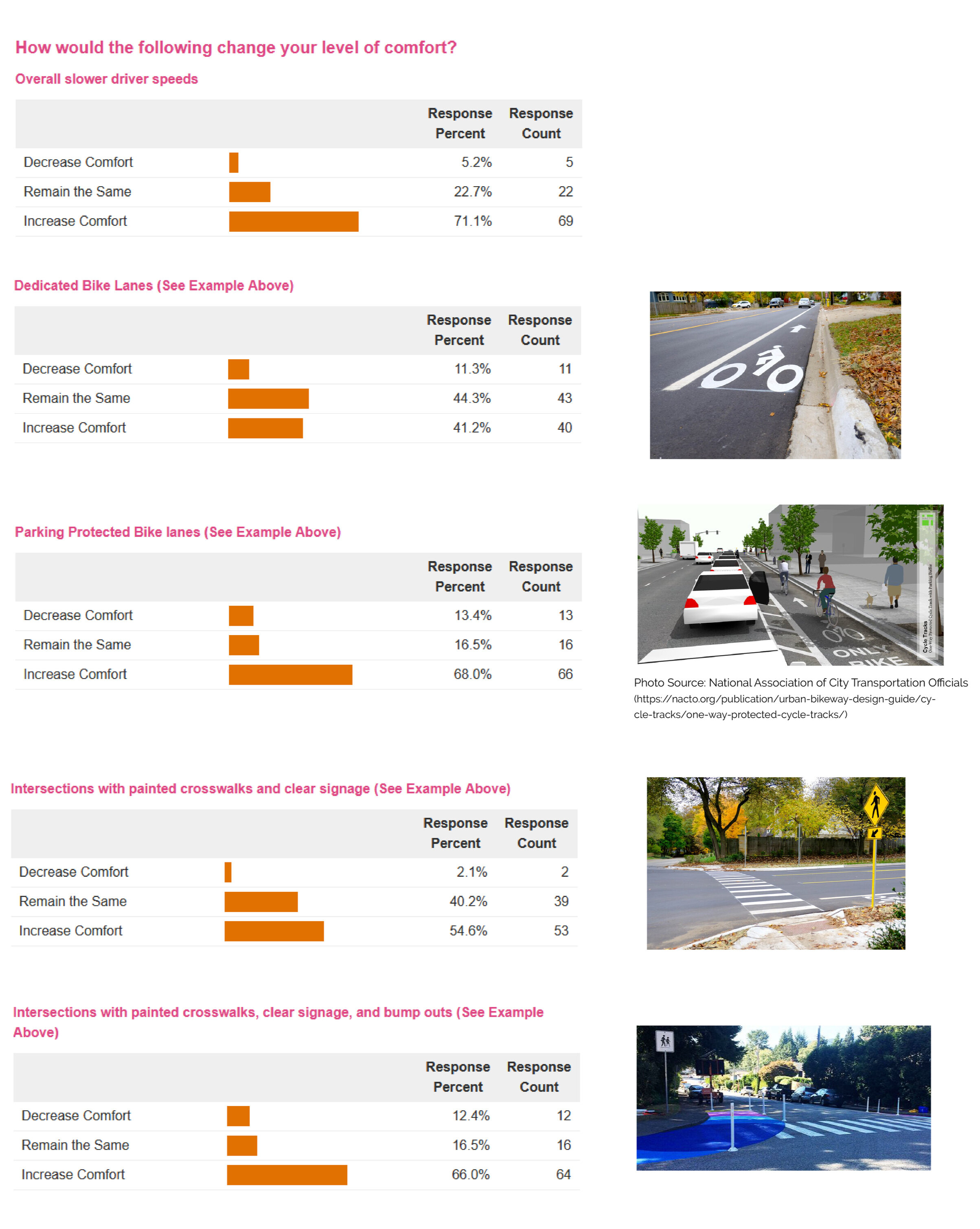
The online survey also asked a series of questions about improving comfortability. A summary of responses to those questions are available below.
Map Input
The map below includes compiled community input that was collected on printed maps at in-person community events and as pins dropped on an online map. Residents were asked to share their biking/walking routes, priority intersections for improvements, intersections that are difficult to cross on foot, and spots where sidewalks or curb ramps were missing or needed repairs along Westendge Avenue and Park Street. Open Map in Full Screen
Traffic Crash Data
To understand the existing issues with Westnedge and Park, the City of Kalamazoo gathered traffic crash data for both streets over the past nine years. In the maps below, you will see each major intersection and the total number of crashes (car, pedestrian, and bicyclist).
Westnedge & Park Vehicle 9 Year Intersection Crash Data (North)

Westnedge & Park Walk/Bike 9 Year Intersection Crash Data (North)

Westnedge & Park Vehicle 9 Year Intersection Crash Data (South)

Westnedge & Park Walk/Bike 9 Year Intersection Crash Data (South)
